Description
First Ascent of Peak 6113.5 m
Geographical Information
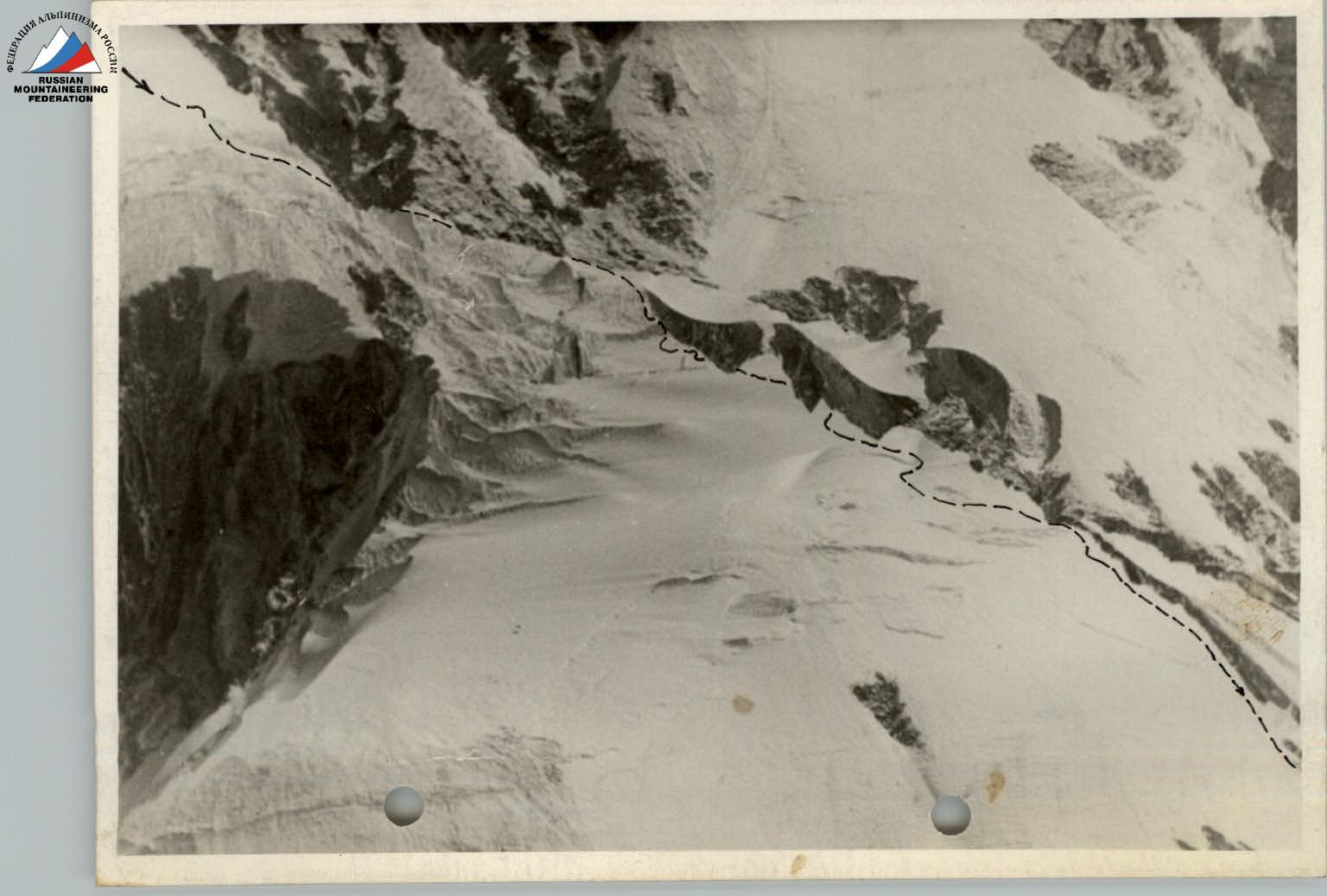
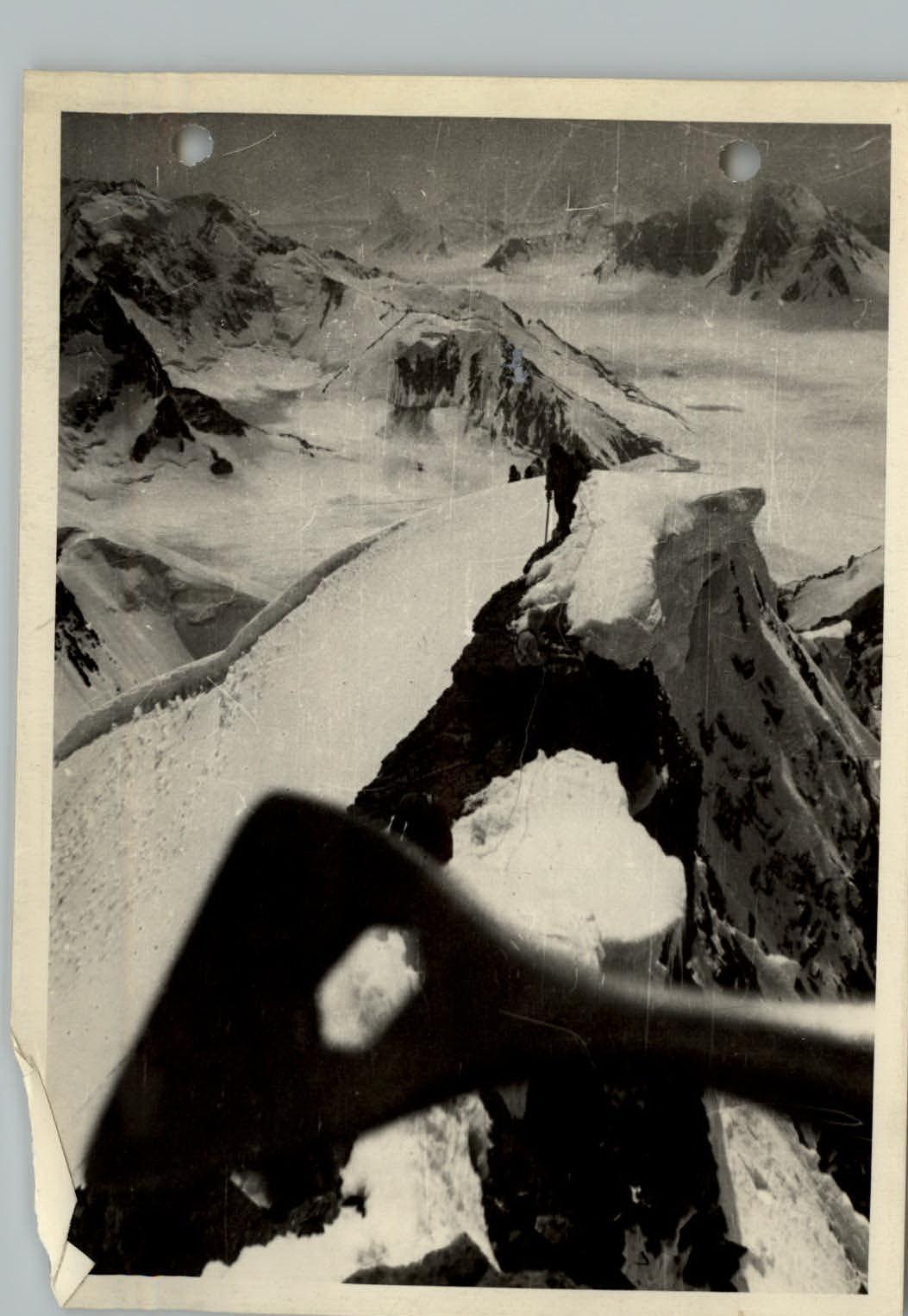
Peak 6113.5 m (photo 1) is located in the southeastern part of the Fedchenko Glacier, in the Vysokaya Stena range. Four glaciers originate from its slopes:
- The northern slopes give rise to the Tanymas 3 glacier;
- The western slopes feed the second (unnamed) glacier, which is a right tributary of the Fedchenko Glacier;
- On the southwest, a third (unnamed) glacier flows, which is the last right tributary of the Vitkovsky Glacier;
- To the south flows the fourth glacier, also a right tributary of the Vitkovsky Glacier.
Approaches
The group of first ascensionists approached Peak 6113.5 m on July 27, 1962, from the base camp (altitude 3900 m) located on the shore of a lake at the confluence of the Kaskadny Glacier with the Abdukagor Glacier.
The ascent to the Fedchenko Glacier (to the Upper Base Camp - altitude 5000 m) was made via the Abdukagor Pass (altitude 5100 m).
The path to the Abdukagor Pass followed the left side of the Abdukagor Glacier. The icefall was also traversed on the left side of the glacier, and as the ascent progressed, the path proceeded mainly through the middle part.
The Abdukagor Glacier can pose significant difficulties in the second half of summer. In its most challenging part, it is necessary to circumvent frequently encountered crevasses; higher up, the glacier is closed but has a large number of crevasses, so it is necessary to travel in rope teams with great caution all the way to the Abdukagor Pass.
The ascent from the Lower Base Camp (3900 m) to the Upper Base Camp (5000 m), located on the Fedchenko Glacier near its left bank below the Abdukagor Pass, takes one day (about 10 hours).
Due to bad weather (continuous cloud cover and snowfall), the group of first ascensionists stayed in the Upper Base Camp on July 28 and continued their approach to Peak 6113.5 m only at 17:00 on July 29, 1962.
The path to Peak 6113.5 m from the Upper Base Camp initially follows the middle part of the Fedchenko Glacier, leading to a large lake located under the northern slopes of the southern group of mountains of the Fedchenko Glacier. Movement is always in rope teams.
Crossing the Vitkovsky Glacier is dangerous and practically difficult to accomplish in the second half of the day. In addition to numerous transverse deep crevasses filled with water, two large streams flow on the surface of the glacier in its middle part. They can only be crossed in the morning.
The group stopped for the night near the first stream (July 30, 1962). Early in the morning, over the frozen firn, the group crossed both streams and approached the confluence of the southeastern glacier from Peak 6113.5 m with the Vitkovsky Glacier. From here, the ascent of Peak 6113.5 m began.
Assault on Peak 6113.5 m
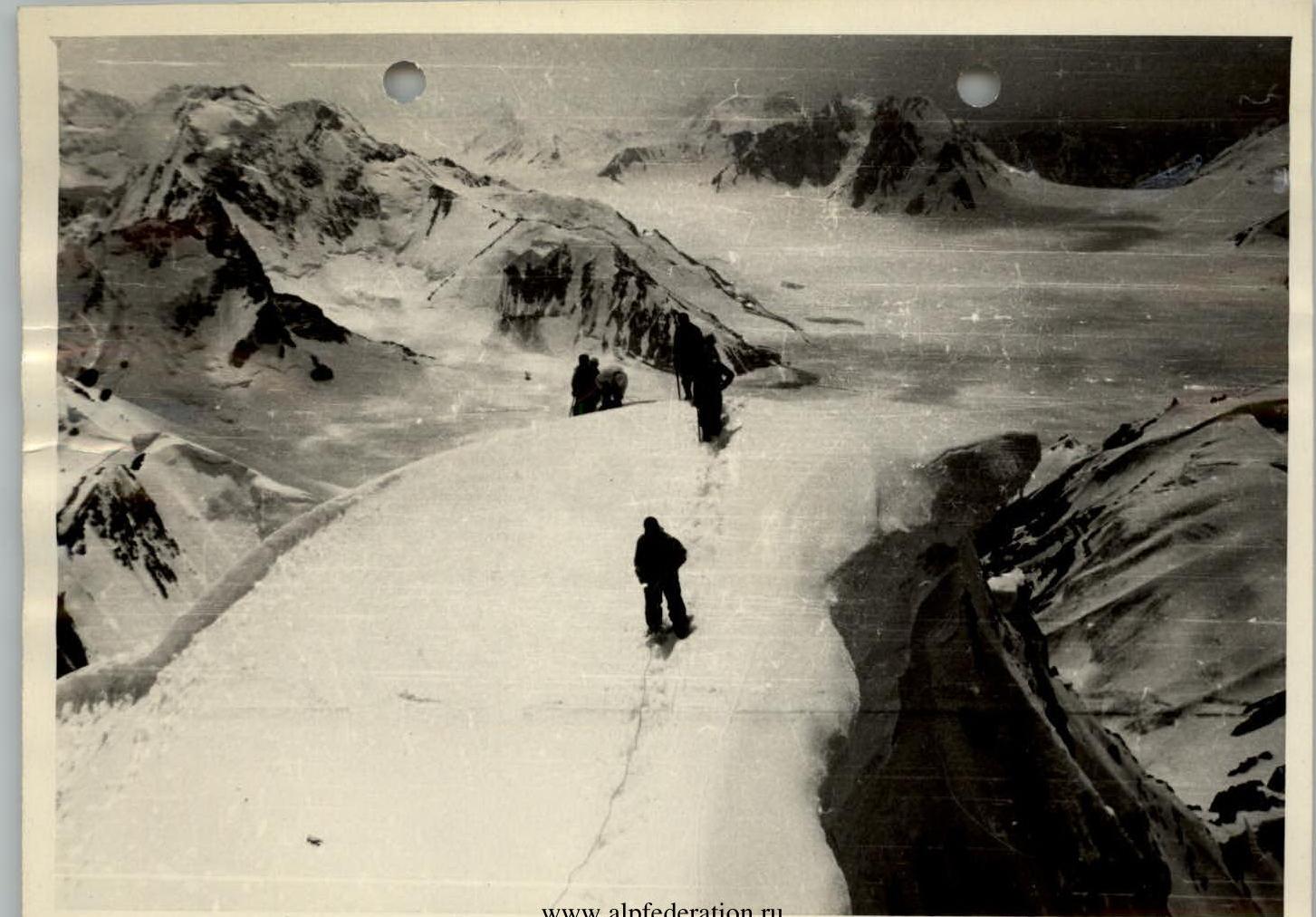
On July 30, 1962, the group started ascending via the southwestern glacier of Peak 6113.5 m. The route followed the middle part of the glacier, which is safe from snow avalanches and rockfalls that can occur from the steep banks of the glacier.
Passing through this glacier in its lower course is complex: in this part, it drops steeply downward (overall steepness in this section is 40°), forming a series of wide and deep crevasses, which required descending to the bottom. Descent into and exit from the crevasses were accompanied by constant step cutting. The greatest danger and psychological difficulty in traversing this section are posed by hidden crevasses, of which there are many. Despite careful probing with an ice axe (almost every meter of the route was probed, and this for 5 hours of movement), there were many instances of falling into crevasses. However, thanks to the group's vigilance and reliable belays, no one was injured. The altitude gain in this section was 150 m according to the altimeter. Overcoming crevasses and ice walls is shown in photos № 2, 6, 7, 8, 9, 10, 11, 12. The route's character remained such from the tongue to the middle part of the glacier. The second half of this route is more tranquil and mainly involves overcoming closed crevasses without significant altitude differences.
The ascent to the western ridge of Peak 6113.5 m was made roughly in the middle between Peaks 6113.5 m and 5672 m, at a point where the ridge has the least steepness.
The height difference from the glacier's surface to the ridge is 250–300 m.
The slope is mixed: snow-ice; steepness is 35°–40° (photos 13, 14).
Movement is alternating; belays are through an ice axe, and in the upper part, through rock outcrops.
There is a significant avalanche danger along the entire stretch from the base of the slope to the exit onto the ridge. The high avalanche risk is due to the slope being generally icy, covered with snow 25–30 cm thick, and heavily saturated with moisture. In the second half of the day, under the sun's influence, the adhesion between the snow layer and the ice becomes minimal.
The group traversed this section of the route precisely during this most dangerous time of day.
It is recommended:
- To pass this section in the morning.
In the middle part of the slope, there is ice (over 3 rope lengths) with an exit onto wet rocks. The rocks are of medium difficulty.
Further along a steep snow slope, the group reached the ridge.
Near the rocks, they organized a bivouac. There was water. The altitude was 5600 m (photo 15).
On July 31, 1962, the group left the bivouac onto the ridge at 9:00 (at sunrise). Almost at the bivouac level (100 m higher), they traverse to the right along the slopes of the first gendarme. The slopes are rocky, steep, and heavily fragmented. Then, they cross two couloirs, each about 15 m wide, with ice patches:
- They had to cut steps.
They enter a third couloir with a steepness of 30–40° and numerous loose rocks. Exiting the couloir, the group moves along the middle ridge (3–4 rope lengths) and then along a snow slope to reach the second gendarme (photo 16). The descent from the second gendarme is made along a snow slope with rock outcrops. The snow is not deep and does not hold well on the rocky base, so the descent was made with careful belaying through outcrops (over 2 rope lengths).
Along a snow ridge, sometimes very narrow (5–6 rope lengths), the group approaches the base of a rock wall. The wall, 80–100 m high, is circumvented on the right via a steep snow-ice couloir. Movement for the entire group through the couloir is not safe due to loose rocks. Movement is alternating with belays through outcrops.
The couloir leads to the ridge after 4 rope lengths.
Further movement occurs along the axial part of the ridge. The first ascent on the ridge is made head-on. The rocks are of medium difficulty, with a steepness of 60°. The passage is complicated by the fact that ledges and crevices are covered with an ice crust. Movement is very slow and with careful belaying. The height of the ascent is 50 m.
The subsequent path (3–4 rope lengths) is simple and almost horizontal. They approach the base of the second ascent. The height of this ascent is 80 m, with an overall steepness of approximately 60°.
The lower part (2 rope lengths), the simplest and most gentle, is traversed with simultaneous movement.
The upper part (one rope length) is the most complex and dangerous, passing above the northern, almost sheer wall. The most challenging section of the rock is the last 10 m before reaching the ledge. The danger is exacerbated by:
- huge loose rocks that are difficult to circumvent;
- crumbly rock, making it impossible to drive in pitons.
Belaying is through outcrops.
From the ledge, the path follows relatively easy rocks (3 rope lengths) to the base of the third ascent (photo 17). The height of this ascent is about 50 m. This is the most challenging rock section of the entire route. The steepness is about 80°, with an overhang in the upper part. The lead climber of the first rope team passed this section with great difficulty and not without risk, as the crumbly rock did not allow for a piton to be driven in, making reliable belaying difficult. The other group members traversed this section using free climbing and slightly to the right of the lead climber's path.
Further along, the ridge significantly narrows. The group moves simultaneously along a relatively even, though narrow, ridge. Then (after 2 rope lengths), movement is blocked by a steep rock outcrop 7–8 m high (photo 18), which cannot be circumvented. With some effort, they overcome it head-on.
Descending from the first outcrop, the group follows a very narrow snow ridge (2 rope lengths) and encounters the next (second) rock outcrop (photo 18), which is circumvented on the right; they reach a huge snow cornice (photos 19, 20).
After examining the path, it became clear that the most challenging section of the entire route begins here (photos 20, 24).
Descending from the cornice, the group found themselves facing a thin snow bridge over a deep chasm in the ridge. In the middle, the bridge is very thin. It is clear that it will not support a person's weight. At this point, the lead climber makes a large step and, smoothly and with great difficulty, crosses to the other side. Jumping is completely unacceptable due to the fragility and narrowness of the bridge (about 30 cm).
After crossing the bridge, they approach a rock outcrop 5–8 m high. The rocks are of medium difficulty but are wet and overhang the abyss on both sides of the ridge. After traversing one rope length along the rocks, they reach an exceptionally sharp section of the ridge. Movement is only possible astride. It is useless and dangerous to push off with feet: the loose snow constantly gives way underfoot. They had to work with their hands: hugging the ridge wide and pressing against it with their chest, they cautiously move forward. Thus, they traverse about 40 m, after which they reach a rock outcrop up to 5 m high, very sharp. It is overcome without particular difficulty.
Beyond this outcrop, the same picture repeats: again, a sharp snow ridge, occasionally interrupted by small rock outcrops, along which they slowly move forward astride towards a large rock located on the edge of a huge crevasse, as if cutting off the southwestern ridge from the main massif.
The distance from the cornice along the described sharp ridge to the rock is about 100 m. At this point, the ridge is almost horizontal. According to the altimeter, the absolute altitude at this section of the ridge is 6050 m. Traversing this section took 4 hours.
Further, the group crosses a snow bridge with great caution over a crevasse in a hanging glacier (by crawling). Belaying is through a piton driven into a large rock. The width of the crevasse at the crossing point is about 2 m. It should be noted that a couple of weeks later, crossing the crevasse would have become a difficult task, as the bridge would have definitely melted.
Beyond the crevasse, the path follows a very steep snow-ice slope (approximately 55–60°), extending about 70 m. The thickness of the snow layer on the ice base averages no more than 15 cm along the slope. The snow is loose and adheres poorly to the ice slope. Walking in crampons is no less dangerous than without them, as crampons quickly fill with snow, and constantly clearing snow from crampons on a steep slope is not very convenient, if not very dangerous. The slope is traversed with step cutting over a 30 m section. For belaying, it is necessary to drive in at least three ice screws.
After overcoming the described steep ascent, the group reaches a narrow snow ridge leading to a rock tower (7–8 rope lengths). From the rock tower to the summit, a narrow snow ridge leads with a slight ascent (3 rope lengths). This section is traversed with simultaneous movement all the way to the summit.
The summit (photos 22, 23, and diagram) is a wide area (20 people can fit comfortably), littered with large boulders of soft rock. A cairn is erected. A note from Tajik climbers is left inside.
They reached the summit at 14:45. 15 minutes later, they began their descent via the ascent route.
The weather began to deteriorate:
- a strong frosty wind picked up (bodies grew numb);
- visibility significantly worsened.
Fearing further deterioration in weather, the group descended as quickly as possible towards their bivouac. At 21:30, the last rope team descended to the bivouac.
By morning, the weather had stabilized. Quickly packing up their camp, the group, with good snow crust and in crampons, rapidly descended onto the Vitkovsky Glacier, then onto the Fedchenko Glacier, and back to the Upper Base Camp. Leaving the bivouac at 7:00, the group arrived at the Upper Base Camp on the Fedchenko Glacier at 19:00 on August 1, 1962.
As the first ascensionists, the group named the conquered peak "G.S. Titov Peak".
Comparing the route taken with all previous ascents in this and other regions, the group evaluates it as a Category 5A route. Subsequent ascents on classified routes in this area:
- Omar-Khayyam - Category 4B;
- Green - Category 4A, etc.
— only confirmed the group's assessment of the route to "G.S. Titov Peak".
Time Calculation for the Ascent
First day: Upper Base Camp - Vitkovsky Glacier - 3 hours. Second day: Vitkovsky Glacier - bivouac on the ridge - 11 hours. Third day: bivouac - summit - bivouac - 12 hours 30 minutes. Including ascent - 8 hours, descent - 4 hours 30 minutes. Fourth day: bivouac on the ridge - Upper Base Camp - 7 hours. TOTAL: 33 hours 30 minutes.
List of Participants in the Ascent of "G.S. Titov Peak"
Surname, First Name, Patronymic
Category: Home Address
- SHUKUROV Anvar Gayratovich (leader): 1st category, Dushanbe, Gagarina St., 29, apt. 6
- KRYUKOV Viktor Ivanovich: 2nd category, Dushanbe, Komsomolskaya St., 24, apt. 20
- PAN'KOV Rostislav Grigorievich: 2nd category, Dushanbe
- PEKARSKY Valentin Vsevolodovich: 2nd category, Dushanbe, Popova St., 80, apt. 12
- KORZHAVIN Leonid Ivanovich: 2nd category, Dushanbe
- KOZHUKHIN Yuri Mikhailovich: 2nd category, Dushanbe
- AKHMEDSHIN Mingazim Kasymovich: 2nd category, Dushanbe
- Shchebitchenko Vitaly Yurievich: 2nd category, Dushanbe
- FADEEV Boris Sergeyevich: 2nd category, Dushanbe
- IVANNIKOV Vasily Ivanovich: 2nd category, Dushanbe
- LAVRUSHIN Valery Ivanovich: 2nd category, Dushanbe
- LINDT Ivan Ivanovich: 2nd category, Dushanbe
The description was compiled by:
- SHUKUROV A.G.
- PEKARSKY V.V.
- KRYUKOV V.I.
Profile Scheme
Ascent
To Peak 6113.5 m
(Peak "G.S. Titov")
Legend
The route of the first ascent by the Tajik Highland Expedition group (July 27 - August 1, 1962). Bivouacs № 19. Multimedia photographs of sections attached to the report (with the direction of photography). The scheme was compiled by V. Pekarsky.