4. Brief Characteristics of the Ascent
4.1. Ascent Passport
- Ascent class: high-altitude and technical
- Ascent area, ridge: Central Pamir, Vysokaya Stena ridge
- Peak: Tartu University – 350 years height 6350 m ascent route: from Lake Tanymas II via the northwest ridge
- Proposed category of difficulty: 5A
- Route characteristics: height difference: 850 m length of sections with 5th-6th category difficulty: 3 ropes average steepness: 30°–35°
- Pitons driven: for belaying — 27 for creating artificial points of support — 0
- Number of climbing hours: 28 hours
- Number of nights and their characteristics: 2 nights on the ridge
- Surname, name, patronymic of the leader, participants, and their qualification: Muru Kalev Manivaldovich II Hansen Kalle Rikhardovich II Paris Andres Peetrovich II Kallavus Anu Helmutovna II Künnap Jaan Aleksandrovich I Aedviir Kalle Arnoldovich I
- Team coach: Sumeri Lak CMS, instructor I category
- Date of departure and return: August 1 — August 4, 1982
Introduction
In honor of the 350th anniversary of Tartu State University (TSU), the TSU Alpine Club, together with the Tartu City Sports Committee, organized an expedition to the Pamir region, specifically to the Vysokaya Stena area. The goal of the expedition was to conquer an unnamed peak and, in honor of the anniversary, name it after Tartu University, exercising the right of the first ascenders to do so.
Tartu University's connection to mountaineering dates back to the early 19th century. In 1811, a student of the university (later a professor and rector), J.F. Parrot, made several attempts to climb Mount Kazbek. Unfortunately, these attempts were unsuccessful. J.F. Parrot successfully climbed his first peak 18 years later, in 1829, when he, accompanied by Kh. Abovyan and four others, reached the summit of Mount Ararat (5156 m). This year is considered the beginning of mountaineering in the region.
The second goal of the expedition was to honor Parrot's name by assigning it to a previously unnamed peak.
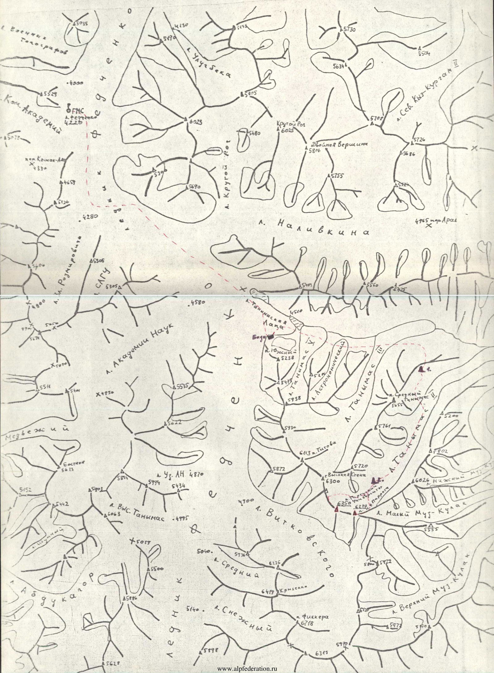
As mentioned above, the expedition was conducted in the Central Pamir, Vysokaya Stena ridge, located east of the Fedchenko Glacier. The choice of this area was based on the following reasons:
- geographical inaccessibility and limited exploration;
- presence of high and difficult-to-reach peaks;
- proximity to the large Fedchenko Glacier, providing a base for movement;
- existence of several unclimbed peaks above 6000 meters;
- possibility of receiving support from the International Mountaineering Camp (IMC) operating under Lenin Peak;
- proximity of the IMC increases safety possibilities;
- stability of good weather in the area.
The expedition preparation occurred in two stages:
- preparatory measures: intensive training, competitions, control ski hikes in the Khibiny Mountains, organizational activities (October 1981 — May 1982);
- training camps in the mountains at the Artuch recreation center (June — July 1982).
The expedition took place from July 15 to August 15, 1982.
4.1. Approach to the Peaks
From Dushanbe, the team traveled by car to Jirgital (280 km). From there, the expedition cargo was transported to the base camp location at Tanymas Lap (height 4700 m). The expedition members were dropped off lower, at the Fedchenko Glacier weather station (4200 m).
From the station, the path went:
- initially along the left part of the glacier;
- then, after the glacier turned, along its right part.
The Fedchenko Glacier was mostly open at this time, with snow covering it only near Tanymas Lap, under which water stood.
The expedition's base camp was set up on the lateral moraine of the Fedchenko and Tanymas Lap glaciers, near the so-called "Yellow Hut" (a former glaciologists' hut).
From the GMS "L. Fedchenko" to the "Yellow Hut" is about 25 km, which took two days (16 hours of climbing time).
According to the reconnaissance group we met at GMS, the best and safest approach to the peaks was from Lake Tanymas II, i.e., from the north. To achieve this, we had to cross the glaciers:
- Tanymas I;
- Tanymas II;
- Tanymas III.
On the left lateral moraine of Lake Tanymas II, after a 9-hour walk, we set up our first intermediate camp.
We continued to move towards the cirque of the chosen peaks along the left lateral moraine of Lake Tanymas II. After 2 hours of walking, we had to switch to the glacier. The glacier was open until the large icefall, which we passed normally, with careful belaying and the use of various ice and snow bridges.
After the icefall, the glacier becomes more even but covered and has fairly large, hard-to-spot crevices. Snow bridges held up well only in the morning and late evening.
The second intermediate camp was set up on the glacier at a height of about 5200 m. From this camp, we launched the assault on the peaks. Communication between groups and the camp on the glacier was maintained using "Kaktus" type radios.
One group's target was the peak marked "6350 m" from the northwest, and the other group's target was the peak marked "6277 m" from the northeast. The group led by Lõhmus A. headed towards the "6277 m" peak (future Peak J.F. Parrot). After 1.5–2 hours of walking, they turned left towards the intended saddle, while the group led by Muru K. continued moving up the glacier towards the saddle between the peaks Chil-chel and "6350 m" (future Peak Tartu University).
Muru K.'s group reached under their saddle at the end of the Lake Tanymas II cirque after a 7-hour walk. At this time, Lõhmus A.'s group had climbed about one-third of the height to their saddle.
The first assault camp for Muru K.'s group was set up directly under the saddle between the Chil-chel glacier and "6350 m", at the beginning of the route. Lõhmus's group stayed overnight in a safe grotto on a snowy slope.

5. Table of Main Characteristics of the Ascent Route
| Date | Stage Designation | Average Steepness | Length (m) | Terrain Characteristics | Difficulty | Condition | Weather Conditions | Rock Pitons | Ice Pitons | Bolt Pitons |
|---|---|---|---|---|---|---|---|---|---|---|
| R0 | 35° | 100 | snowy slope | 3 | excellent | |||||
| R1 | 50–65° | 120 | 5 | loose snow | ||||||
| R2 | 10° | 120 | ridge, rocks, talus | 1 | good | |||||
| R3 | 40–45° | 40 | snowy slope | 3+ | ||||||
| 2 August | R4 | 5–10° | 50 | ridge, snow, talus | 1 | |||||
| R5 | 70–75° | 4 | small wall | 4+ | monolithic, broken | |||||
| R6 | 40–45° | 6 | inclined ledge | 4 | monolithic, icy | 2 | ||||
| R7 | 25–30° | 120 | ridge | 2 | broken | 3 | ||||
| R8 (up–down) | 120 | ridge, rocky, sharp | 3 | broken | excellent | |||||
| R9 | 25° down | 15 | ridge | 1 | talus | |||||
| R10 | 40° | 30 | rocky slope | 3 | broken | |||||
| 3 August | R11 | 75–80° | 8 | small wall | 4+ | broken, icy | ||||
| R12 | 40–45° | 10 | traverse of inclined ledge | 4 | broken, icy | 6 | ||||
| R13 | 65–70° | 12 | small wall | 4+ | broken, icy | 2 | ||||
| R14 | 45–50° | 20 | icy couloir | 4 | ice | 5 | 2 | |||
| R15 | 35–40° | 30 | traverse of snowy slope | 3+ | snow, good at the bottom | 3 | ||||
| R16 | 60–65° | 5 | small wall | 3 | broken monolith | |||||
| R17 | 45–50° | 90 | snowy ridge | 2+ | icy crust | |||||
| R18 | 30° | 200 | snowy ridge | 3 | icy crust, snow | |||||
| R19 | 45–50° | 60 | snowy slope | 4+ | icy crust, rocks | |||||
| broken, snow |
Descent along the ascent route to the saddle
4 August Descent from the saddle to the glacier along an old avalanche path on a steep slope (55–60°) for 150 m.
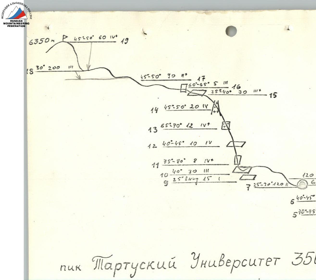
Peak Tartu University 350 years via the northwest ridge, 5A category difficulty.
7. Ascent Log
August 1
We left the second intermediate camp on Lake Tanymas II (5200 m) at 10:00. The weather was excellent: sunny, no wind. We moved in two teams: Muru–Hansen–Paris and Künnap–Kallavus–Aedviir. The snow and snow bridges over crevices held up well until 14:00. Further movement required more attention and physical strength. By 17:00, we successfully reached under the ridge between the peaks Chil-chel and the future Peak Tartu University. We set up a night camp on the glacier at an elevation of 5500 m.
August 2
We started on the route at 7:00. It was cold, with firm snow. We quickly covered the first three ropes. We reached the bergschrund, from where a steep slope began up to the ridge. We organized reliable belaying, and Aedviir started moving up. Within an hour, he successfully passed two ropes, found the most "gentle" section of firn snow, and organized a rope handrail there using several ice axes. The second climber could use Aedviir's steps only 50% of the time because under the upper crust, the snow was very dry, and under the sun's influence, the upper layer became softer. The third climber moved on their knees, and the last members practically "swam" up, leaning on the rope.
The entire group reached the ridge by 15:15. After resting for a couple of hours, we continued moving along the ridge and searching for a bivouac site. The ridge was of a broken type, with southern slopes mostly snow-free and huge snow cornices hanging on the northern side. On section R3, the slope had good firm snow. After the snowy slope, one rope length was relatively flat, ending with a small wall 4 m high. We passed it from left to right, followed by an inclined ledge. There were few handholds, and we used piton belays.
Further along the ridge, there were many gendarmes that could be bypassed on both sides. We set up the tent between gendarmes in a relatively flat spot, approximately at a height of 6100 m.
August 3
In the evening, we went to take a closer look at our key location. It turned out to be possible to bypass the right upper part of the wall on one shoulder. We started the assault at 8:30.
From under the wall on the ridge, we descended about half a rope length (R9). Then, we traversed to the right and slightly upwards. There was a rocky "fist" (R11). Piton belay! The rocks were covered in snow and ice, with "live" outcrops! After the "fist," we traversed to the right for 10 m. The rocky slabs were icy, with "live" outcrops and handholds (R12). At the end of the traverse, there was a vertical rock where we could organize a belay point.
To the right of this wall was a broken and snow-covered small wall (R13), followed by an icy couloir. There, we could use both ice screws and pitons for belaying. We reached the shoulder.
Then, we traversed the southern slope. Under the snow, there was an unpleasant rocky monolith. Through a not-too-difficult small wall (R16), we reached a talus slope. Another 30–40 m, and we were on the ridge.
It was now clear that we would reach the summit today, August 3, 1982. We left our backpacks on the ridge (it was 11:15) and continued the ascent. The obstacle before the summit was a steep snowy slope (R19) with good firm snow.
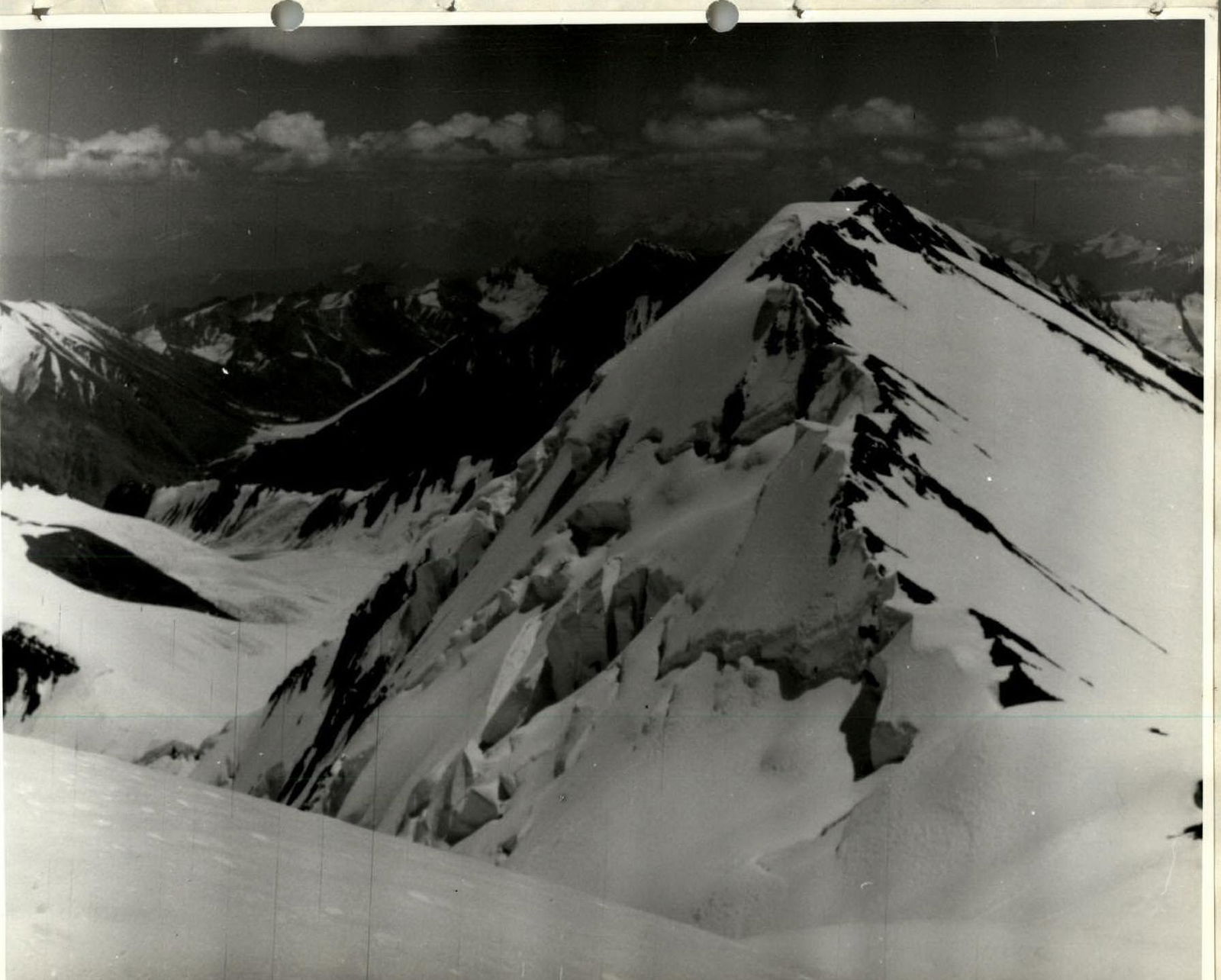
We conquered the summit at 13:45. We took photos and built a cairn. Near the cairn, we fixed a commemorative plaque.
We began our descent from the summit at 15:30, following the ascent route. By 19:30, we were back at the night camp on the ridge (R2).
August 4
We started descending from the ridge at 6:30 because the snow was still good and firm then. We descended traversing three rope lengths to the right until we reached old avalanche tracks. New cornices on top had not yet formed. We descended quickly, organizing belays with ice axes. We continued down the glacier and were at the site of the second intermediate camp on the Tanymas II glacier by 11:00.
View from the summit towards Peak J.F. Parrot