
4.12 44851 Committee for Physical Culture and Sports under the USSR Council of Ministers
Climbing Department

Ascent to the summit of Peak "Vspomogatelnykh" (Helpers)
Peak "Vspomogatelnykh" is located in the southwestern spur of the western ridge of Peak Ficker.
Day 1
From the base camp, the group's route went along the left-bank moraine of the Abdukagor glacier to the point where the Kaskadny and Obval glaciers flow into it. Here, the moraine descends, and there is a fairly convenient exit onto the ice. The group crossed the merged Kaskadny and Obval glaciers and reached the left-bank moraine of the Abdukagor glacier, which turns sharply northeast at this point (1 hour).
A trail along the moraine (along the stream) leads to a flat area with water (1 hour). Slightly above the area, the group descended from the moraine of the glacier and moved towards the middle part of the icefall formed by the left (orographic) branch of the Abdukagor glacier, divided by a rocky ridge into two parts (30–40 minutes).
The icefall was traversed somewhat to the right in the lower part and somewhat to the left in the upper part (in the direction of travel) (1 hour). Above the icefall, three not very steep ascents were traversed, alternating with more gentle sections.
The glacier is closed, and in some places heavily crevassed.
The ascent from the foot of the icefall to the pass is 500–600 m (3–3.5 hours).
Above the last ascent, the glacier becomes more gentle and transitions into the snowy plateau of the Abdukagor pass.
On the right (in the direction of travel) side of the pass plateau, a cave was dug. There is water in the snow-ice depressions. Elevation 5100 m.
Day 2
The group left the cave on the Abdukagor pass early in the morning; descended from the pass to the Fedchenko glacier and crossed it to the right (in the direction of travel, towards the cirque of Peak Ficker). Overcoming two ascents of small steepness, they reached the slopes of Peak SKAN and dug a cave in the left (orographic) part of the Ficker glacier.
There is water in the snow-ice depressions.
The Fedchenko glacier is closed.
Travel time is 4–5 hours.
The snow, which became wet by mid-day, greatly hindered movement.
Day 3
Early in the morning, we set out for the upper part of the cirque of Peak Ficker. When exiting onto the snowy fields of the SSW slope of the SW spur of the western ridge of Peak Ficker, we overcame a simple bergschrund. Before us was a slope of increasing steepness (30–50°) extending up to 500 m with individual rocky outcrops in the middle part.
We moved simultaneously towards the first rocky outcrop. A snowy ridge leads from it. We traversed it simultaneously (2 ropes). Then, we traversed to the right and upwards along a steep (45–50°) ice slope (snow 10–15 cm) in the direction of the upper edge of the second large rocky outcrop ("finger").
Having passed under the "finger" and going around it to the left, we exited onto the ridge via an ice wall, cutting through a small cornice.
Six ice screws were hammered in on the traverse section, and 2 rock anchors were placed when exiting onto the ridge.
The ridge is steep, with snow lying on the ice. At the beginning of the ridge, there is a large cornice (to the left in the direction of travel). The ridge is traversed with alternating belays. Three ice screws were hammered in. In the upper part, the ridge becomes more gentle and leads to a saddle.
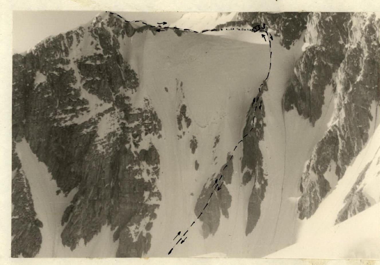
The ascent route. Overcoming the section took 8 hours. Bivouac on the saddle between Peak "Vspomogatelnykh" and Peak Ficker. There are good areas for tents, but no water.
Day 4
The further path to the summit along the SW ridge was first through fairly simple rocks, then along a snowy-ice ridge. Traversing a 10 m long, 50° steep snowy-ice wall from the south (ice axe did not hold, snow was not consolidated with ice) on crampons and with hook protection, we exited onto the western slope of the summit dome.
The summit is a 10–15-meter cornice to the NE, so a cairn was built on a rocky outcrop southwest of the slope, just below the summit cornice.
The intended descent route turned out to be too hazardous: the ridge is an alternation of steep rocks with fragile snowy bridges between them and long, sharp cornices on both sides.
Therefore, we descended along the snowy fields into the southern cirque of Peak Ficker. During the descent, 8 ice screws and 3 rock anchors were hammered in.
The descent took 10 hours.
A more justified descent along the ascent route is also possible. Then, from the second cave, the ascent can be completed in 14–16 hours.
The technical difficulty of the snowy-ice route is not less than on Shkhara (category 4B), and somewhat more complicated than on Dykh-Tau (category 4A), but the route to Peak "Vspomogatelnykh" is somewhat shorter than to Shkhara and Dykh-Tau.
The group assesses the route to Peak "Vspomogatelnykh" as category 4A.
Group composition:
- Leader: Kalachev L.D.
- Participants:
- Milshtein I.M.
- Goryacheva V.S.
- Zatrudina R.F.
- Spassky V.V.
- Lyubimov Yu.N.
- Ershov I.A.
- Reznikov B.A.
- Serebryakov V.I.
- Kuznetsova G.D.