
Appendix №3 Description of the First Ascent Route to Peak Vas'kova D (A. Abramov, 1976) in the Database of Climbing Route Descriptions FAR №2840.pdf
PAMIR
BERUOVIE
LETNIK
FERMENO
Description of the first ascent to Peak T.E. Vas'kova (6100 m) via a combined route of 5A category difficulty along the southern ridge.
The first ascent was made by a group from the Chelyabinsk Regional Council of the "Trud" sports society on August 24, 1976.
The team consisted of: Leader I. A. Ya. Abramov, 2. G. P. Lernovoi, 3. G. S. Yazovskikh (leader of the first ascent to Peak Vasilyeva via a 4A category route in 1967). Launching officer - B.G. Tarkhanov - Master of Sports in mountaineering, senior instructor.
Chelyabinsk Regional Mountaineering Federation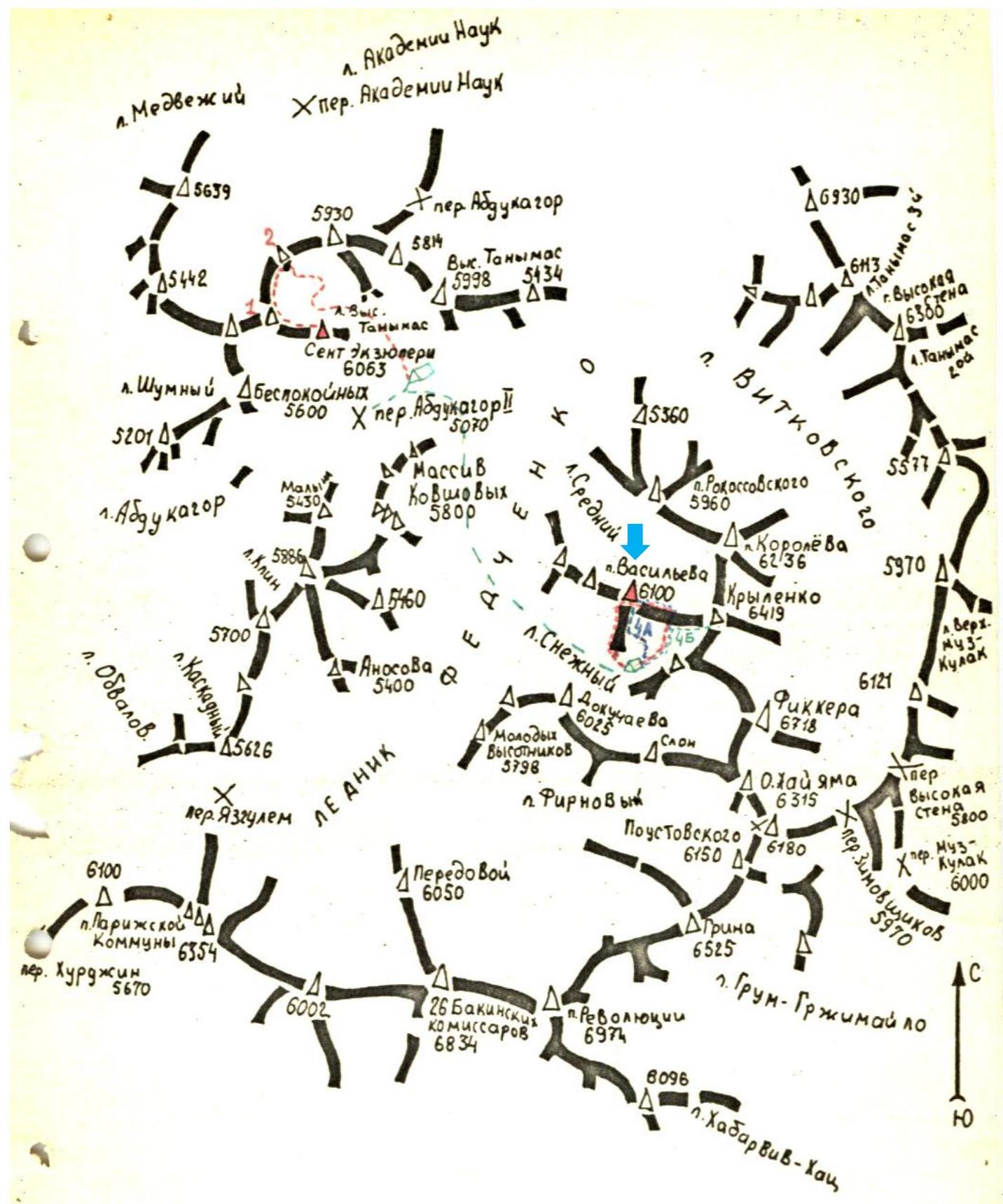
Central Pamir
Kherby Vergovy, Fedchenko glacier
Introduction
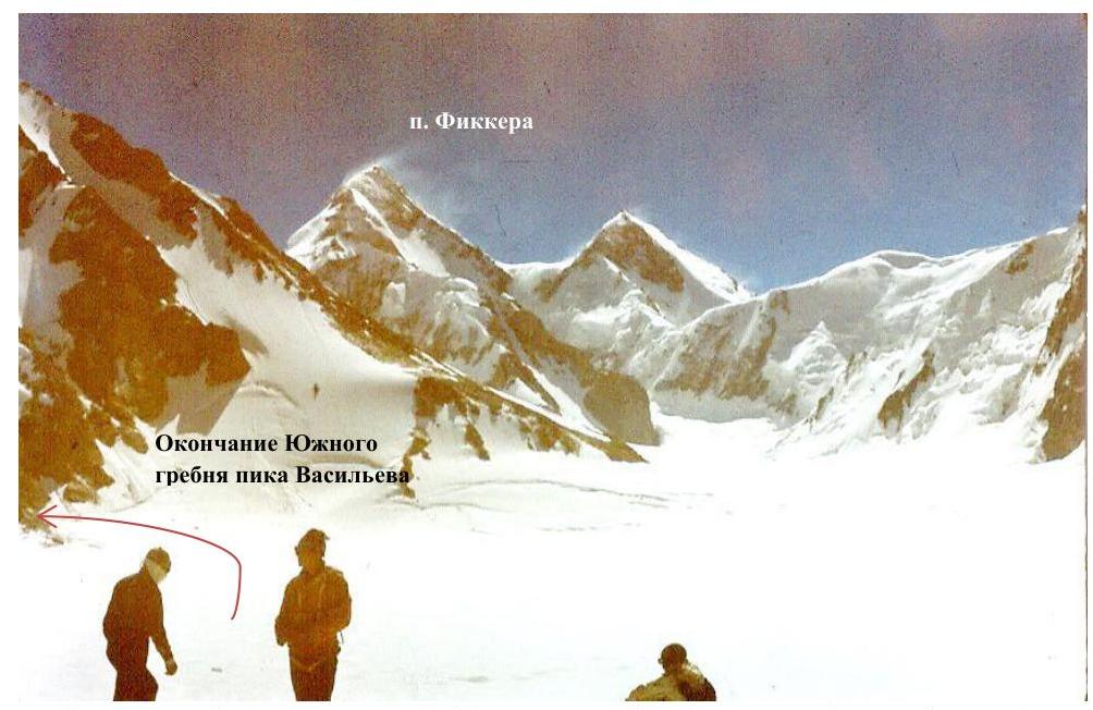
Peak L.K. Vasilyeva (6100 m) is located in the western spur of the main ridge of the Fedchenko glacier group. This spur starts from Peak Krylenko (6419 m) and divides two small glaciers - Sredny and Snezhnny, which flow into the Fedchenko glacier. To the south of Peak Krylenko stands Peak Fickera (6718 m).
The approach to the summit lies from the Abdukagor-P pass:
- Up the Fedchenko glacier
- Further to the summit of 26 Baku Komsomol members
- We pass the neighboring Sredny glacier with the Vitkovsky glacier
- Crossing the Fedchenko glacier, we head towards the second glacier from the Vitkovsky glacier, the Snezhnny glacier.
The path from the Abdukagor-P pass to the Snezhnny glacier takes 3-4 hours.
The path to the start of the route goes along the gentle, closed Snezhnny glacier, above which the summit of Fickera rises. In the upper part, the glacier is divided into two parts by the western ridge of Peak Fickera.
Under the shelf ridge of Peak Vasilyeva, near the start of the route, we set up a camp, approximately at an altitude of 5300 m.
The start of the route lies through step-like wall sections of the branched counterforts at the end of the shelf ridge of Peak Vasilyeva.
The path taken by the first ascenders lies along the eastern slope of this shelf ridge, with an exit onto it, and is much to the right of our route.
The ascent route of our group was planned along the left branch of the central counterforts at the end of the shelf ridge, with an exit onto the counterfort and further up to the junction of the central and right counterforts into a single ridge, then an exit to the upper point of the counterforts' "paw", and then along the ridge to the meeting with the route of 4A category difficulty and along it to the summit.
The descent path:
- Along the ridge towards Peak Krylenko
- To the Snezhnny glacier
General Characteristics of the Route
The route consists of the following main stages:
- 0 - I: Ascent along the left crack of the central counterfort with an exit onto the counterfort and an approach to the red upper belt of rocks (First Control Point).
- I - II: Crossing the couloir and approaching the wall of the right counterfort.
- II - III: Exit onto the right counterfort.
- III - IV: Ascent to the upper point of the counterforts' "paw" (Second Control Point).
- IV - V: Approach to the rocks of the summit tower (overnight stay).
- V - VI: Bypassing the summit tower and ascent to the summit.
- VI - VII: Descent from the summit to the lower part of the ridge between Peak Vasilyeva and Peak Krylenko.
- VII - VIII: Descent from the ridge to the Snezhnny glacier.
Technical Description of the Route
From the assault camp, we approach the start of the route along the rocks (section 0-1). Time: 8:00. We link up under the route and begin passing the first rock section.
We ascend along the left crack of the central counterfort, then deviate left along a fracture and exit upwards onto rocks of medium difficulty, leading in steps. The first 40 m of rocks are passed.
The next 40 m are passed along walls about 5-7 m high, with good vertical cracks. On the last 25 meters, many loose rocks are encountered. Passing them, we exit onto a shoulder strewn with small stones falling from above.
Further, we move along rocks of medium difficulty and exit to the meeting point of the central counterfort's splits into a single counterfort (40 meters).
The subsequent 60 m of the path lie along the ridge of the counterfort, consisting of walls with a steepness of 60-70°, of medium and above medium difficulty. To the right of the central counterfort, a couloir runs, along which stones rarely fall; to the left, the rocks slightly overhang. The last 10 meters are difficult rocks; the first climber has to ascend without a backpack, leaving it on a hook. About 180 meters have been passed from the start of the route. Time: 10:30.
The next 20 m of passage lie along monolithic rocks in the form of two walls, 10 m high, with a minimal number of holds, and we exit under a rock wall on the ridge of the counterfort in the form of "feathers", 20 m long. Having passed the "feather-like" rocks, we exit to the meeting point of our ridge with a crumbly ridgelet. At the meeting point, there is an accumulation of large, broken-off slabs, forming a kind of shoulder.
Then, 20 meters of passage lie along rocks of medium difficulty, with a steepness of about 60-70°, ascending small walls, and we enter rocks of loose structure, resembling loose sandstone. On a wall with loose rock, 10 m high, with a steepness of 80°, we hammer in pitons and, traversing it to the right, enter a small platform.
Again, a wall, 6 m high, consisting of clay and sand, at the end of which a narrow ridge is visible. When overcoming this wall, we have to cut steps for ourselves, using them as handholds. In the middle of the wall, we hammer in a long piton for insurance. Deviation to the right is dangerous here, as the right part of the wall is composed of loose stones embedded in sandstone.
Having overcome the last wall, after 15 m of climbing along rocks of medium difficulty, we enter a narrow ridge, also consisting of sandstone. Holding onto its right side, after 10 m, we exit under a rock wall in the form of a monolithic "tooth". To the right of it, a wide part of the couloir separates the central and right counterforts.
Under the "Tooth" rock, we leave the first control point. About 300 m have been passed from the start of the route.
We bypass the "Tooth" to the right along ledges upwards (section 1-2), about 20 m, then 15 m upwards, and enter under the upper loose belt of rocks. Along ledges, we cross the couloir to the right (40 m) and enter its narrow upper part. We exit under the wall of the right counterfort.
We overcome the wall with a steepness of 80-85°, having a vertical, inclined crack extending to its middle. Further, there are rocks of very difficult category with a very limited number of holds. Having passed 60 meters from the start of the wall (section R2-R3), we enter the shoulder of the right counterfort. Then, there are rocks of medium category, with sections of difficult category, about 60 m long; having passed them, we enter under the start of a small snowfield descending towards the eastern slope of the ridge (section R3-R4).
We bypass the snowfield along its upper edge (small, piled-up stones), approach rock steps leading to the upper point of the counterfort's "paw".
Overcoming these rocks, we exit under a snow cornice. The length of the rocks is about 80 m. Having passed the cornice, we exit onto the eastern ridge of Peak Vasilyeva. Time: 15-20 minutes. About 560 meters have been passed from the start of the route. We leave the second control point and begin moving along the fairly wide ridge to the exit onto the route of 4A category difficulty (section 4-5). Along the ridge with a steepness of about 15-20°, with rock walls 6-10 m high of medium difficulty, we pass about 200 meters.
The next 250 meters are traversed along the route of 4A category difficulty. We approach the snow-ice "blade", descend from the ridge to the left (in the direction of travel). At this point, the ridge becomes narrow; to the right, cornices overhang, the line of their breakage is difficult to determine.
The steepness of the ice is about 65°; insurance is piton-based; we cut steps. The length of the "blade" is about 70 meters.
Having passed the ice "blade", we enter under a rock buttress. We bypass it to the left along rocks and further along the snow-ice ridge, with inclusions of rocks, holding onto its left slope, and approach steep pre-summit rocks. About 120 m have been passed.
To the right, a large cornice descends to the east. Before us lies a snow-ice slope with a steepness of 60°, transitioning into rocks of the summit part.
- Time: 20:00
- About 1200 m have been passed from the start of the route
We cut out a place for a tent and settle in for the night.
In the morning, at 9:00, we begin passing the last section of the ascent (section 5-6). We bypass the rock section of the ridge to the right (in the direction of travel) along the ice slope covered with snow 3-6 cm deep. We ascend to the first rock island. We have traversed 120 m from the overnight stay. Then, we move to the second rock island (40 m). Further, along the edge of snow and rocks, we exit onto the saddle between the main summit and the buttress located on the ridge leading to Peak Krylenko (60 m). From the overnight stay to the saddle, we have traversed 220 m. The steepness of the slope is about 36°.
From the saddle, we ascend upwards along ice with a steepness of 70° - 20 m and begin bypassing the rocks to the left.
After about 20 m, we exit under a rock wall 10 m long. The rocks are difficult. The first 4 m are passed using a "sling". Further, along rocks of medium difficulty, we exit onto the pre-summit dome (30 m). Another 40-50 m, and we exit onto the summit of Peak Vasilyeva.
We found an old cairn with a note from the first ascenders of 1967, led by G.S. Yazovskikh. We leave a note on the pre-summit rock pass, on which we fix a memorial plaque in honor of D.E. Vasilyev using a piton. To the plaque, we tie a can with a note. Time: 13:00.
The descent path of our group is similar to that of the first ascenders. It goes along the ridge leading to Peak Krylenko, to its lower part. The entire path lies along the snow-ice ridge. From the ridge, we descend along the route of 4-5 category difficulty to Peak Krylenko towards the Skezhny glacier. The descent takes 7 hours.
Recommendations for the Route
-
The route should be started early in the morning.
-
The entire group should have crampons.
-
It is mandatory to bring a tent, bags, and down gear.
-
The following is necessary:
- Pitons - 10 pieces
- Rock pitons - a set of pitons and ice axes, about 15 pieces.
-
When exiting onto the upper pinnacle of Vasilyeva from the saddle, the rocks are bypassed only on the left side in the direction of travel, as there is a larger overhang to the right.
-
The descent from the upper pinnacle can be made either along the ascent route of 4A category difficulty or along the route of 4C category difficulty to Peak Krylenko.
-
An overnight stay can be organized only on a glacier.
-
Ascent along a different direction of the counterforts' "paw" is more dangerous (stonefall), but not less difficult than the one we passed.
Table of Main Route Characteristics
The combined route to the summit of Peak Vasilyeva has a total length of 2450 m, of which 1530 m is ascent to the summit, including complex sections:
- Rock - 250 m
- Ice - 300 m
- Rock - 30 m
The average steepness of the route is 50°, including complex rock sections - 80°:
- 50° - average steepness of the route
- 80° - steepness of complex rock sections
- Ice - 60°
- Rock - 50°
Time of exit from the assault camp: 8:00 on August 23, 1976.
Time of reaching the summit: 13:00 on August 24, 1976.
Time of return to the assault camp: 20:00 on August 24, 1976.
Total walking hours - 23. Total walking hours - 50 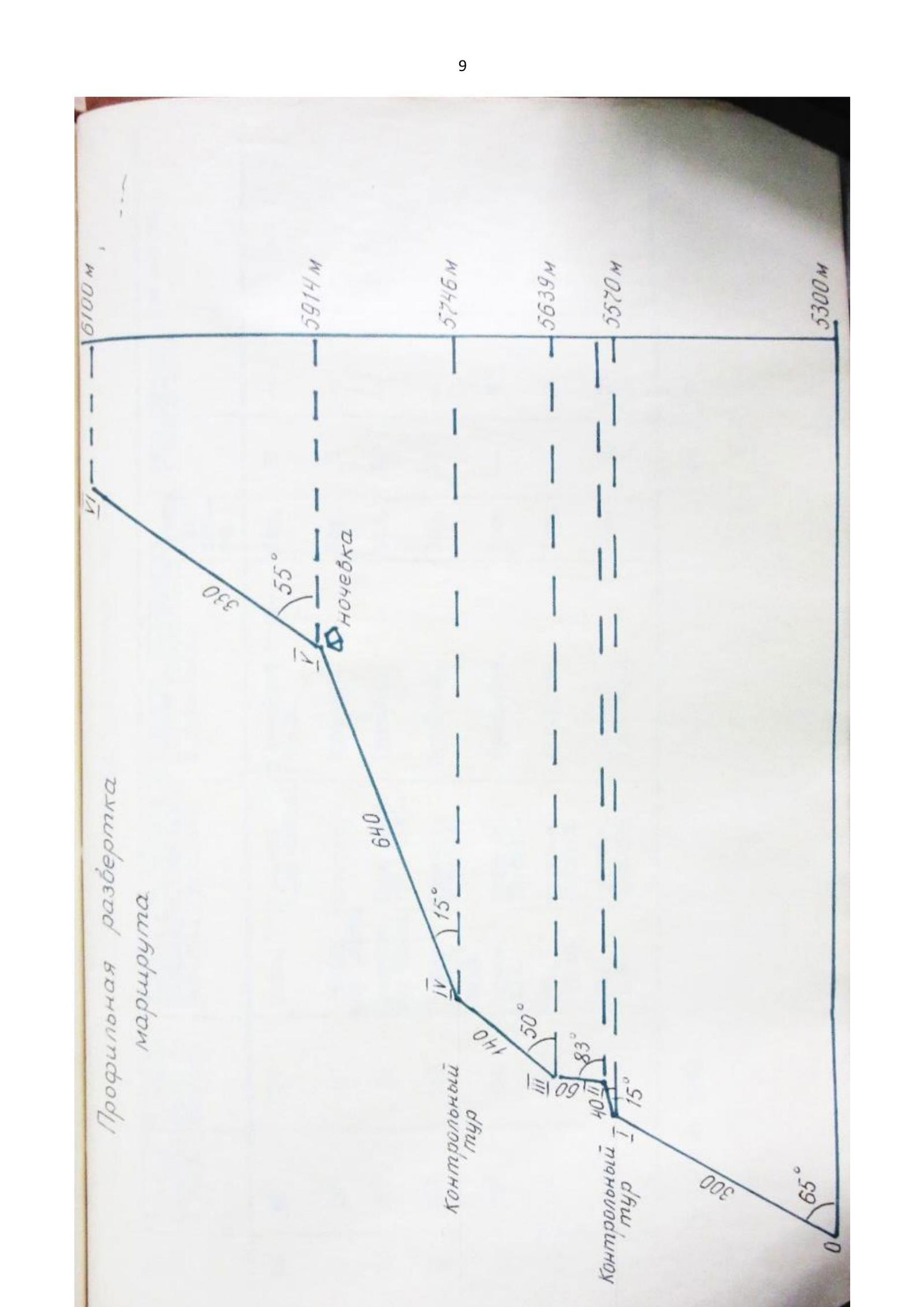
Longitudinal Unfolding of the Route
| 1. | 55° | 300 | Rocks | Medium | Steep, with crevices | Average | 32 | 32 |
|---|---|---|---|---|---|---|---|---|
| of varying heights, with holds. | ||||||||
| 2. | 15° | 40 | Rocks | Medium | Gentle | Average | 3 | 3 |
| of medium height. | ||||||||
| 3. | 50° | 50 | Rocks | Medium | Steep | Average | 10 | 10 |
| with sections of easy difficulty. | ||||||||
| 4. | 50° | 140 | Rocks | Medium | Steep | Average | 10 | 10 |
| Rocks | ||||||||
| 5. | 15° | 640 | Rocks | Medium | Gentle | Average | 5 | 5 |
| Ice | ||||||||
| 6. | 55° | 330 | Ice | Difficult | Steep | Average | 8 | 7 |
| Rocks | ||||||||
| 7. | Mixed | Ice | Medium | Ice axes | Average | 4 | 15 | |
| Rocks |
Total: 2450
57 27
Proposals for Route Evaluation
Considering the height of the route (5300-6100 m), the length of difficult rock and ice sections, and the methodology for determining route difficulty categories given by A.F. Naumov in the book "Karaugom, Digoria, Phei", Moscow, 1976, we propose that the route be evaluated as 4-5 category difficulty.
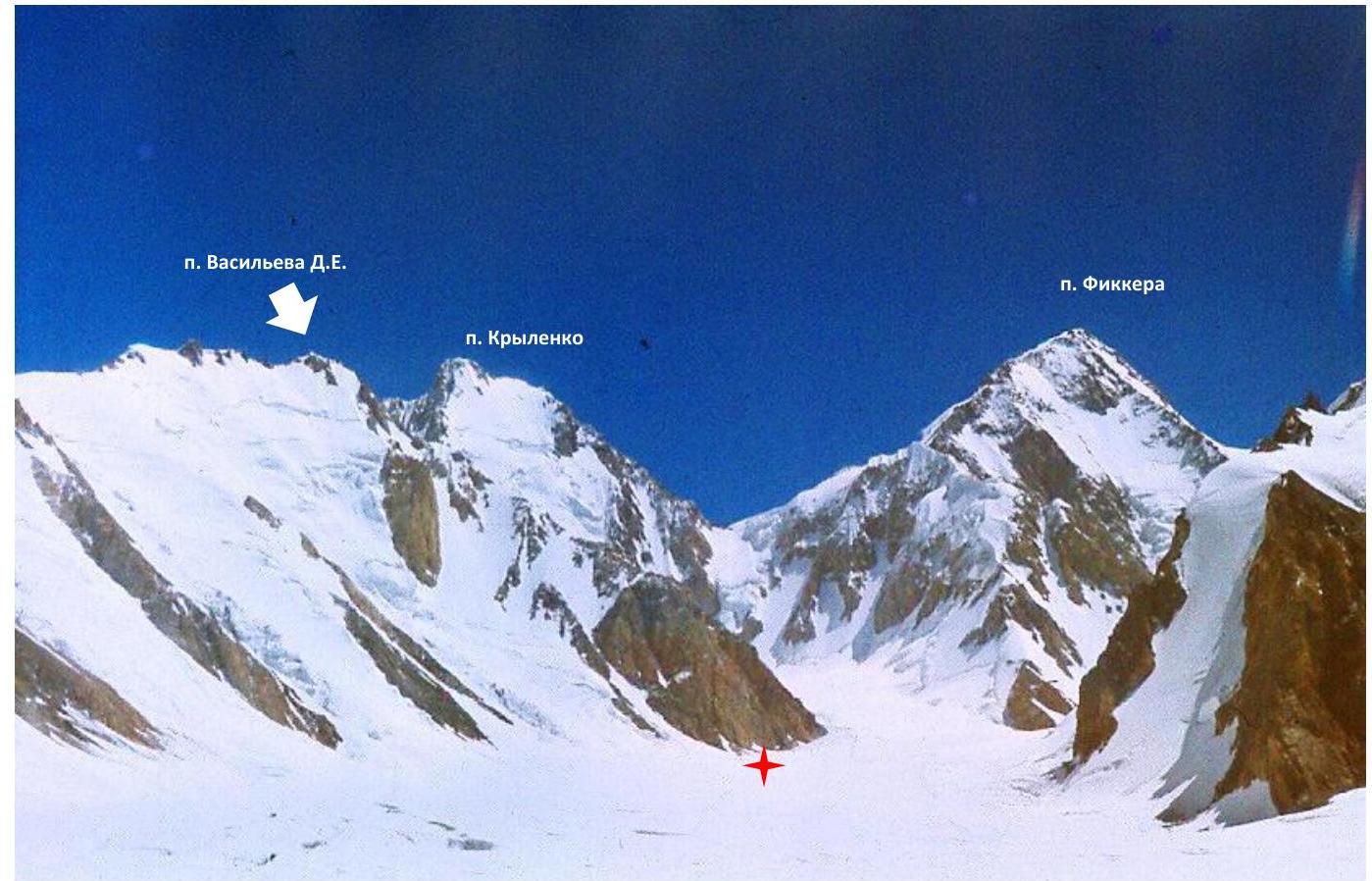
Western slope of the S. ridge of Peak Vasilyeva D (overlaps with Peak Krylenko)
Assault camp near the end of the S. ridge (Western slope) of Peak Vasilyeva D
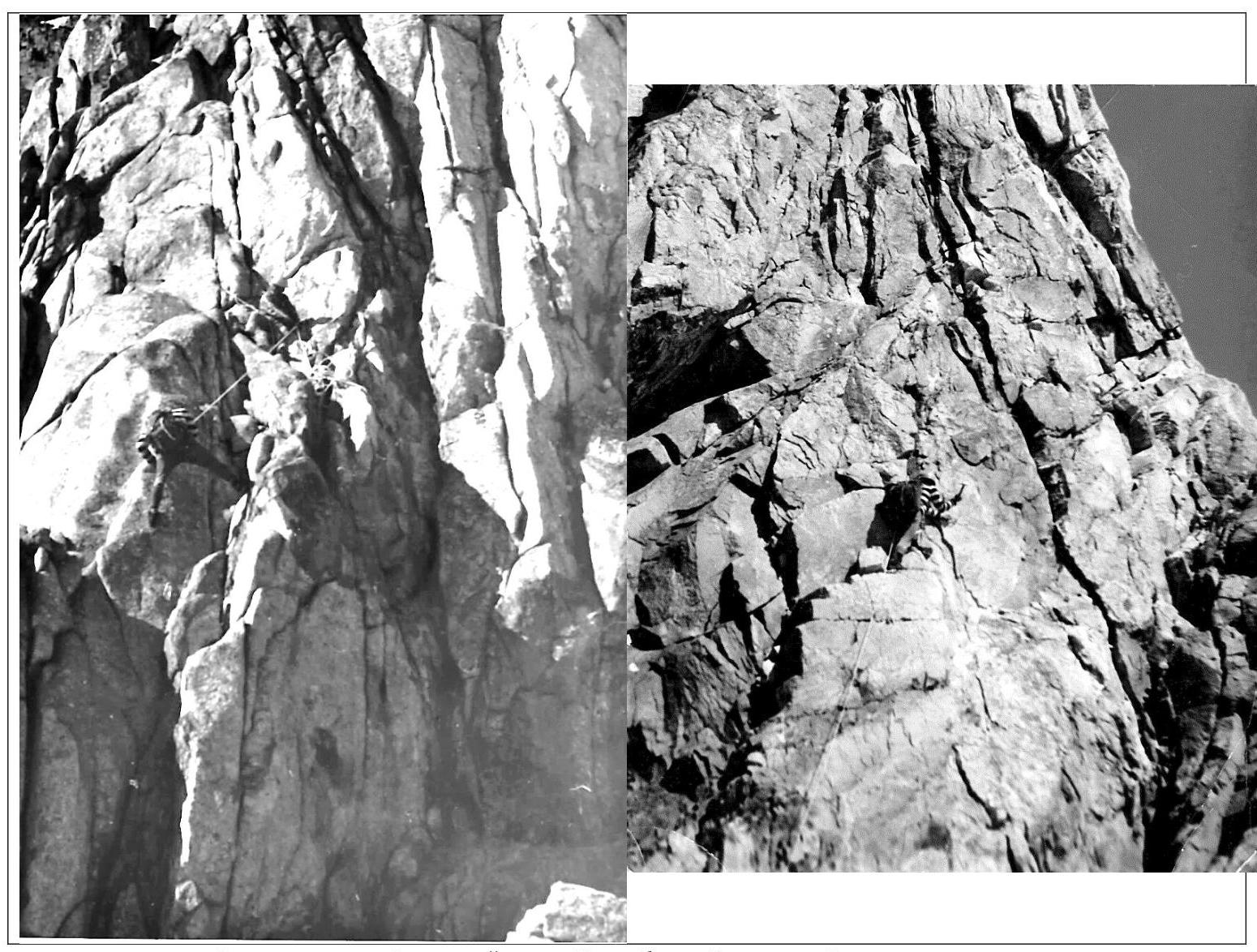
Rock wall on the Western slope of the S. ridge of Peak Vasilyeva D, start of the route
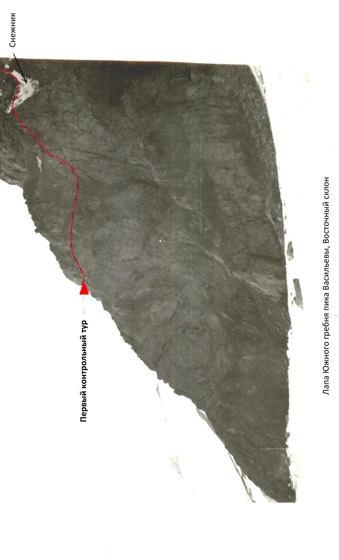
"Paw" of the S. ridge of Peak Vasilyeva, Eastern slope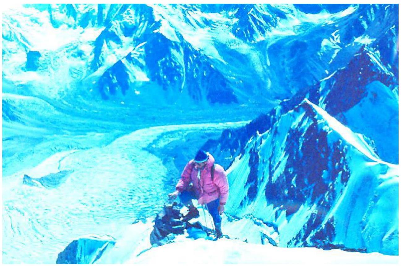
Exit onto the S. ridge of Peak Vasilyeva D (first control point)

Overnight stay on the ridge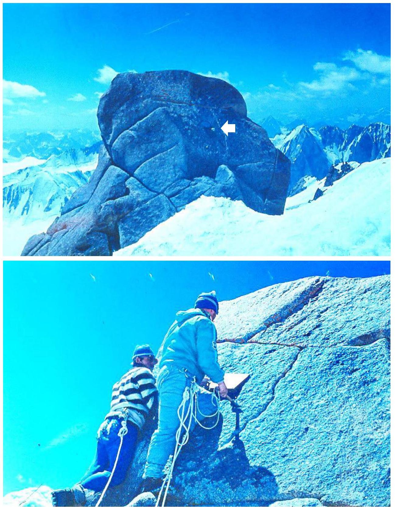
Cairn on the summit of Peak Vasilyeva D, found the note of the first ascenders (G. Lernovoi, A. Abramov)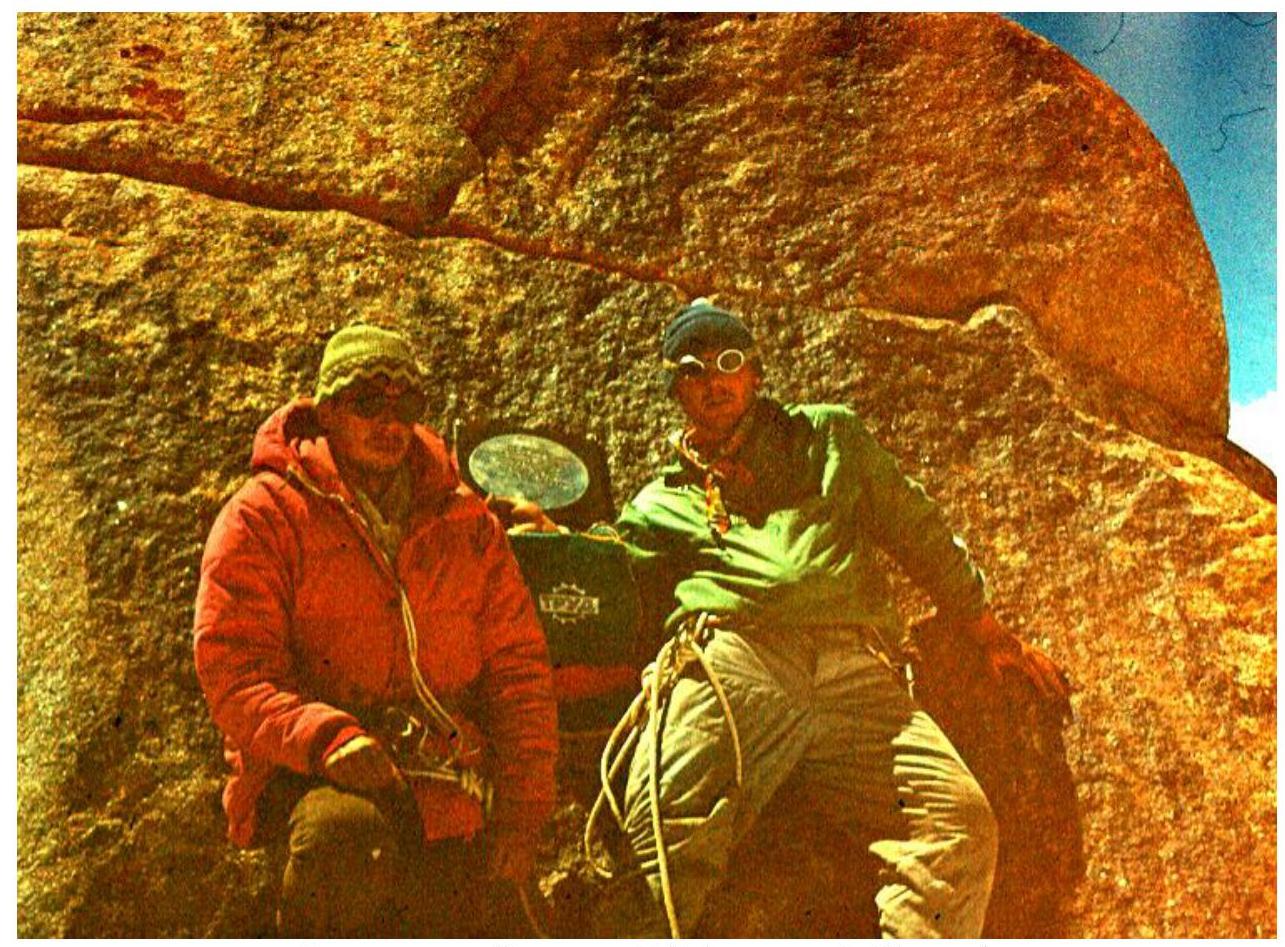
Summit of Peak Vasilyeva D (G. Yazovskikh, A. Abramov)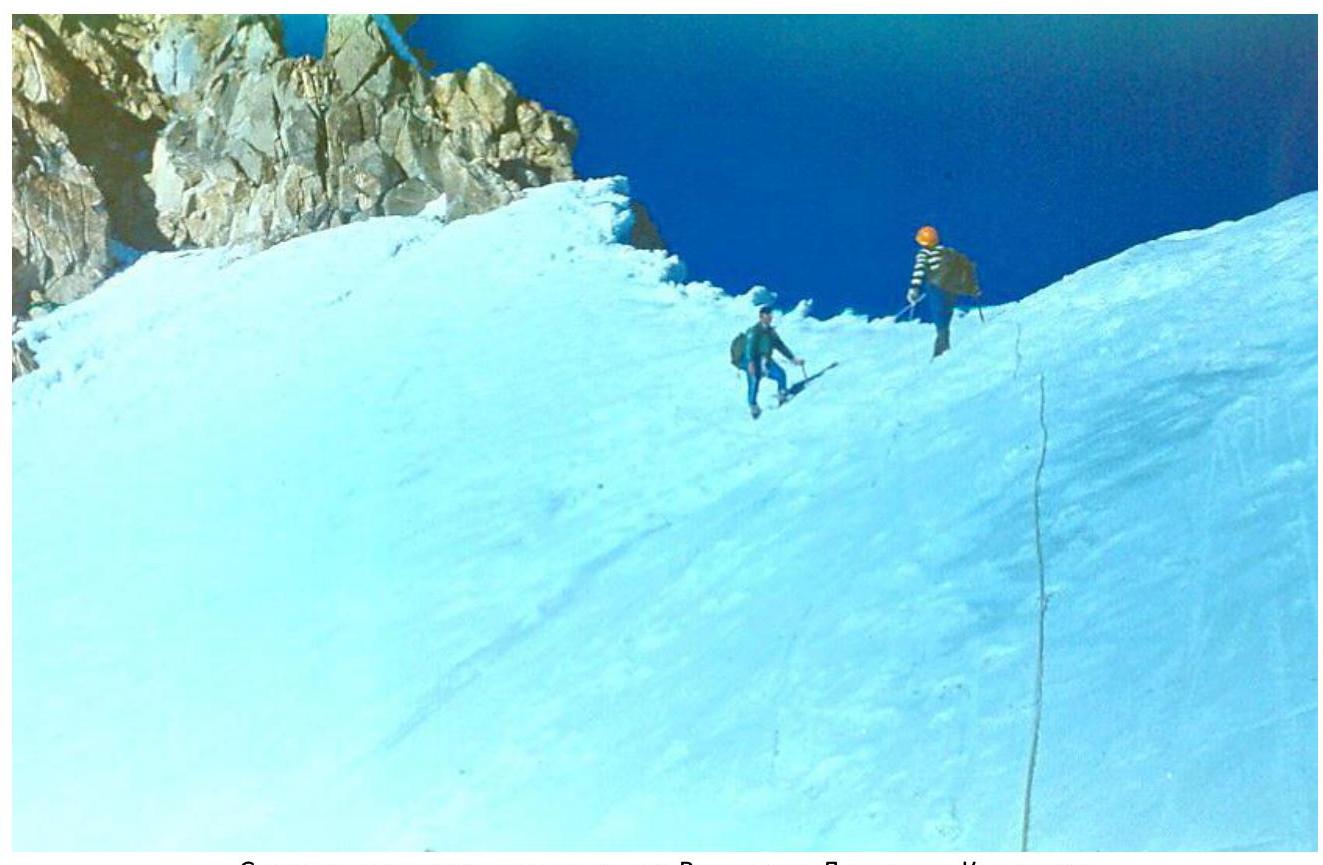
Descent from the saddle between Peak Vasilyeva D and Peak Krylenko