
The first ascent was made by a group from the Chelyabinsk Regional Council of the "Trud" Sports Society on August 24, 1976.
The team consisted of:
- A. V. Abramov
- G. P. Derovoy
- G. S. Yazovskikh (leader of the first ascent to Peak Vasiliev via route 4A cat. diff. in 1967)
Release officer — V. G. Tarkhanov — Master of Sports in mountaineering, senior instructor
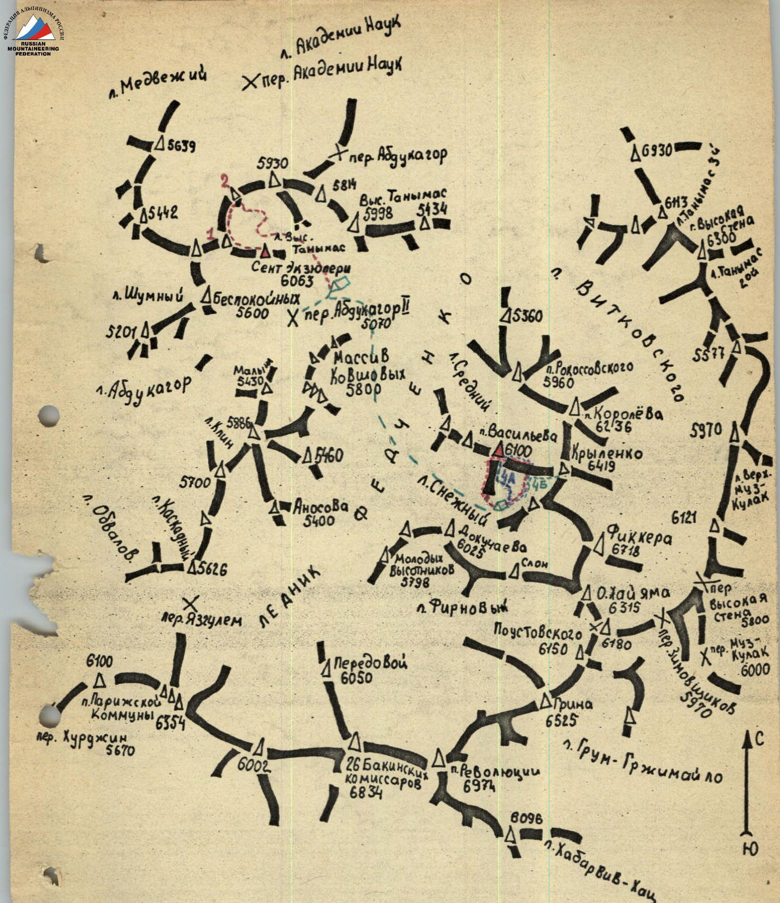
Central Pamir
Ranges of the Fedchenko Glacier headwaters.
Introduction
The peak of D. E. Vasiliev (6100 m) is located in the western spur of the main ridge of the southern group of Fedchenko. This spur starts from Peak Krylenko (6419 m) and divides two small glaciers — Sredniy and Snezny, which flow into the Fedchenko Glacier. To the south of Peak Krylenko stands Peak Ficker (6718 m).
The approach to the peak lies from the Abdugagor-P pass:
- up the Fedchenko Glacier
- further to the peak of 26 Baku Commissars
- we pass the neighboring Sredniy Glacier with the Vikhkovsky Glacier
- crossing the Fedchenko Glacier, we head to the second Snezny Glacier from the Vikhkovsky Glacier.
The path from the Abdugagor-P pass to the Snezny Glacier takes 3–4 hours.
The path to the beginning of the route goes along the gentle closed Snezny Glacier, above the cirque of which the peak of Ficker rises. In the upper reaches, the glacier is divided into two parts by the western ridge of Peak Ficker.
Under the southern ridge of Peak Vasiliev, near the beginning of the route, we set up a camp, the approximate height of the camp is 5300 m.
The beginning of the route is a stepped wall of the branched lap of the counterforts at the end of the southern ridge of Peak Vasiliev.
The path taken by the first ascenders lies along the eastern slope of this southern ridge with an exit to it and is much to the right of our route.
The ascent path of the group was planned along the left separation of the central counterfort of the extremity of the southern ridge, with an exit to the counterfort itself and further up to the convergence of the central and right counterforts into one ridge, then an exit to the upper point of the lap of counterforts, then along the ridge to meet the route 4A cat. diff. and along it to the summit.
The descent path:
- along the ridge towards Peak Krylenko
- to the Snezny Glacier.
General characteristics of the route
The route consists of the following main stages:
- R0–R1: Ascent along the left crevice of the central counterfort with an exit to the counterfort with an approach under the red upper belt of rocks (First control point)
- R1–R2: Crossing the couloir and approaching under the wall of the right counterfort
- R2–R3: Exit to the right counterfort
- R3–R4: Ascent to the upper point of the lap of counterforts (Second control point)
- R4–R5: Approach under the rocks of the summit tower (overnight stay)
- R5–R6: Bypassing the summit tower and ascending to the summit
- R6–R7: Descent from the summit to the lower part of the ridge between Peak Vasiliev and Peak Krylenko
- R7–R8: Descent from the ridge to the Snezny Glacier
Technical description of the route
From the assault camp, we approach the beginning of the route along the rocks (section R0–R1). Time is 8:00 am. Under the route, we tie in and begin to pass the first rocky section.
We ascend along the left crevice of the central counterfort, then move left along a fault and exit up to rocks of medium difficulty, going in steps. The first 40 m of rocks are passed.
The next 40 m are passed along walls about 5–7 m high, having good vertical cracks. On the last 25 m, many loose rocks are encountered. Passing them, we exit to a shoulder strewn with small stones falling from above.
Further, we move along rocks of medium difficulty and exit to the place where the splinters of the central counterfort converge into one counterfort (40 m).
The next 60 m of the path, we move along the ridge of the counterfort, consisting of walls with a steepness of 60–70° of medium and above medium difficulty. To the right of the central counterfort is a couloir, along which stones occasionally fall, to the left the rocks overhang slightly. The last 10 m are difficult rocks; the first person has to ascend without a backpack, leaving it on a hook. About 180 m have been passed from the start of the route. Time is 10:30.
The next 20 m are passed along monolithic rocks in the form of two walls, each 10 m high, having a minimal number of holds, and we exit under a rocky wall on the ridge of the counterfort in the form of feathers, 20 m long. Having passed the feather-like rocks, we exit to the place where our ridge meets a crumbly crest. At the meeting point, there is a pile-up of large split slabs, forming a kind of shoulder.
Then 20 m are passed along rocks of medium difficulty with a steepness of about 60–70°, rising in small walls, and we find ourselves on rocks of a crumbly structure in the form of reddish sandstone. On a wall with crumbly rock, 10 m high, with a steepness of 80°, we hammer in wedges and, traversing it to the right, we get to a small site.
Again, there is a wall 6 m high, consisting of clay and sand, at the end of which a narrow ridge is visible. When overcoming this wall, one has to cut steps for oneself, using them as handholds. In the middle of the wall, we hammer in a long wedge for insurance. Moving to the right here is dangerous, as the right part of the wall is composed of loose rocks embedded in sandstone. Having overcome the last wall, after 15 m of climbing along rocks of medium difficulty, we find ourselves on a narrow ridge, also consisting of sandstone. Staying on its right side, after 10 m we exit under a rocky wall in the form of a monolithic tooth. To the right of it is a wide part of the couloir separating the central and right counterforts.
Under the "Tooth" rock, we leave the first control point. About 300 m have been passed from the start of the route.
We bypass the "Tooth" to the right along the shelves up (section R1–R2), about 20 m, then up 15 m and find ourselves under the upper red belt of rocks. Along the shelves, we cross the couloir to the right (40 m) and find ourselves in its narrow upper part. We have come under the wall of the right counterfort.
We overcome the wall with a steepness of 80–85°, having a vertical inclined crack extending to its middle. Further, there are rocks of very difficult category with a very limited number of uncomfortable holds. Having passed 60 m from the beginning of the wall (section R2–R3), we find ourselves on the shoulder of the right counterfort. Then there are rocks of above medium category, in places of difficult category, about 60 m long, having passed which we find ourselves under the beginning of a small snowpatch descending towards the eastern slope of the ridge (section R3–R4).
Bypassing the snowpatch along the upper edge (small scattered stones), we approach the rocky steps leading to the upper point of the lap of counterforts.
Overcoming these rocks, we exit under a snow cornice. The length of the rocks is about 80 m. Having cut through the cornice, we exit to the southern ridge of Peak Vasiliev. Time is 15:20. About 560 m have been passed from the start of the route.
We leave the second control point and begin to move along a fairly wide ridge to the exit to route 4A cat. diff. (section R4–R5). Along the ridge with a steepness of about 15–20°, with rocky walls 6–10 m of medium difficulty encountered, we pass about 200 m.
The next 250 m, we move along route 4A cat. diff. We approach a snow-ice "blade" descending from the ridge to the left (in the direction of travel). At this point, the ridge becomes narrow, to the right there are cornices, the break-off line of which is difficult to determine.
The steepness of the ice is about 65°, insurance is with pitons, we cut steps. The length of the "blade" is about 70 m.
Having passed the ice "blade", we find ourselves under a rocky gendarme. We bypass it to the left along the rocks and further along the snow-ice ridge with the inclusion of rocks, staying on its left slope, we approach the steep pre-summit rocks. About 120 m have been passed. To the right, to the east, a large cornice descends. Before us is a snow-ice slope with a steepness of 60°, turning into rocks of the summit tower. Time is 20:00. About 1200 m have been passed from the start of the route. We cut out a place for a tent and settle in for the night.
In the morning at 9:00, we begin to pass the last section of the ascent (section R5–R6). We bypass the rocky section of the ridge to the right (in the direction of travel) along the ice slope covered with 3–5 cm of snow. We ascend to the first rocky island. We have passed 120 m from the overnight site. Then we move to the second rocky island (40 m). Further, along the edge of snow and rocks, we exit to the saddle between the main summit and the gendarme located on the ridge leading to Peak Krylenko (60 m). From the overnight site to the saddle, we have passed 220 m. The steepness of the slope is about 55°.
From the saddle, we ascend upwards along ice with a steepness of 70° (20 m) and begin to bypass the rocks to the left.
After another 20 m or so, we exit under a rocky wall 10 m long. The rocks are difficult. The first 4 m are passed with an "elephant's trunk". Further, along rocks of medium difficulty, we exit to the pre-summit dome (30 m). Another 40–50 m — and we exit to the summit of Peak Vasiliev.
We found an old cairn with a note from the first ascenders of 1967, leader Yazovskikh G. S. We leave a note on the pre-summit rocky spire, on which we fix a memorial plaque in honor of D. E. Vasiliev with dowels. We tie a can with a note to the plaque. Time is 13:00.
The descent path of our group is similar to the descent path of the first ascenders. It goes along the ridge leading to Peak Krylenko to its lower part. The entire path lies along a snow-ice ridge. From the ridge, we descend along route 4B cat. diff. to Peak Krylenko towards the Snezny Glacier. The descent takes 7 hours.
Recommendations for the route
- The route should be started early in the morning.
- The entire group should have crampons.
- It is mandatory to bring a tent, chalk, and down gear.
- Necessary pitons:
- ice — 10 pieces
- rock — a set of wedges and wide pitons, about 15 pieces.
- When ascending to the summit of Peak Vasiliev from the saddle, the rocks should be bypassed only on the left side in the direction of travel, as there are large cornices on the right.
- The descent from the summit can be carried out both along the ascent path of route 4A cat. diff. and along the path of route 4B cat. diff. to Peak Krylenko.
- Overnight stay can be organized only on the ridge.
- Ascent along any other route of the lap of counterforts is more dangerous (stones), but not lower in difficulty than the one we passed.
Table of main characteristics of the route
The combined route along the southern ridge of Peak Vasiliev has an approximate length of 2450 m, of which 1530 m is the ascent to the summit, including difficult sections:
- rock — 250 m,
- ice — 300 m,
- snow — 30 m. The average steepness of the route is 50°, including difficult sections of rock — 80°, ice — 60°, snow — 50°. Time of exit from the assault camp at 8:00 on August 23, 1976. Time of reaching the summit is 13:00 on August 24, 1976. Time of return to the assault camp site is 20:00 on August 24, 1976. Total travel hours are 23.
| № | Average steepness, degrees | Length, m | Character of relief | Conditions of passage. Difficulty | Method of overcoming and insurance | Rock pitons | Ice pitons | Note |
|---|---|---|---|---|---|---|---|---|
| 1. | 65° | 300 | Rocks | Medium, above medium | With piton insurance | 32 | – | |
| 2. | 15° | 40 | Rocky shelves | Medium | Piton insurance | 3 | – | |
| 3. | 80° | 60 | Monolithic rocks | Above medium difficulty | Piton insurance | 10 | – | |
| 4. | 50° | 140 | Rocks. Crumbly rocks | Medium. Easy | Piton insurance | 10 | – | |
| 5. | 15° | 640 | Rocks, ice | Medium. Difficult | Piton insurance | – | 5 | |
| 6. | 55° | 330 | Ice, rocks | Difficult. Medium | Piton insurance | 8 | 7 | |
| 7. | Descent | Ice, snow | Medium. Medium | Ice axe. Piton insurance | 4 | 15 |
TOTAL: 2450 m. Pitons driven: 57 rock, 27 ice.
Proposals for route assessment
Taking into account the height of the route (5300–6100 m), the length of difficult rock sections, as well as ice sections, and the methodology for determining the category of difficulty of routes given by A. F. Naumov in the book "Karagom, Digoria, Tsey", Moscow, 1976, we propose to assess the route we passed as a route of 4B cat. diff.
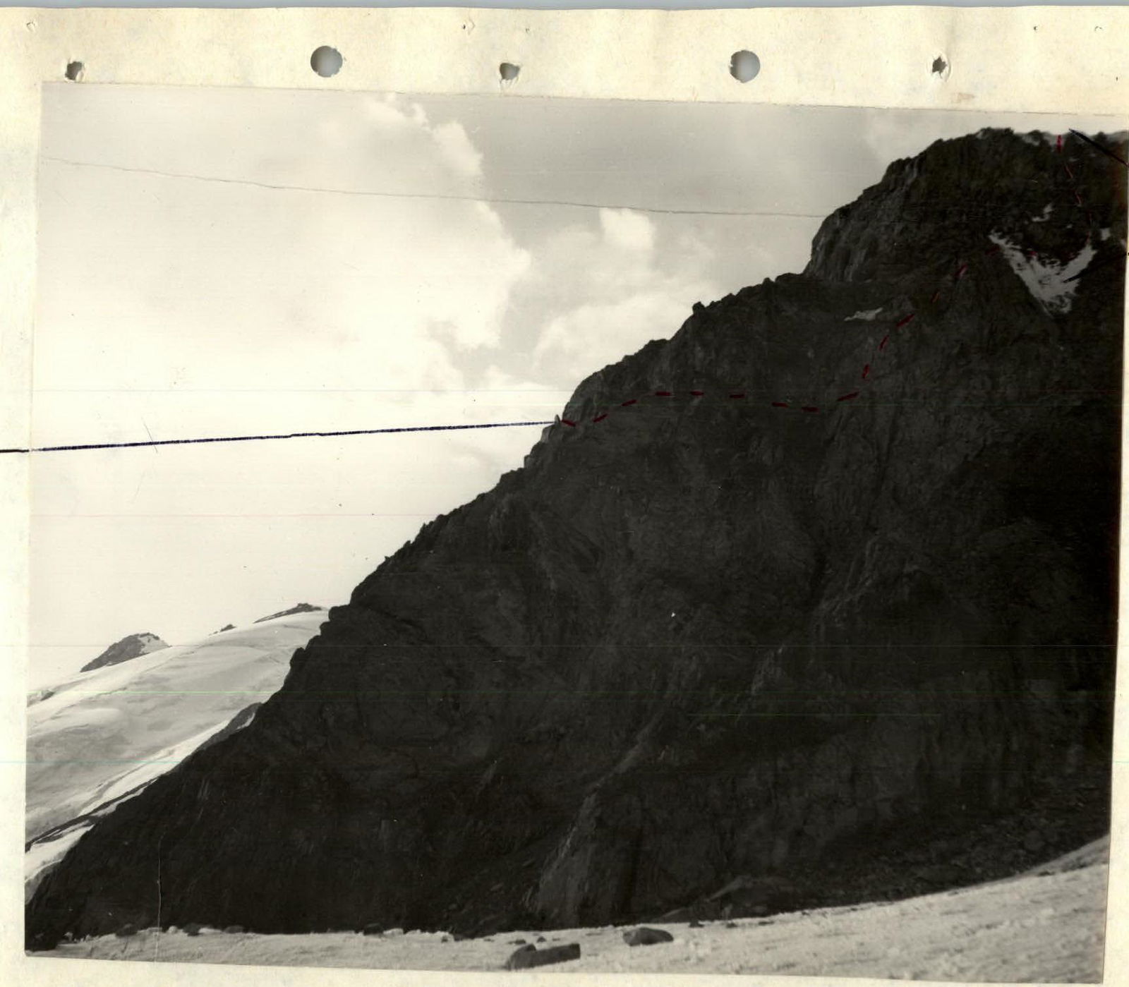
Lap of counterforts (view from the east)
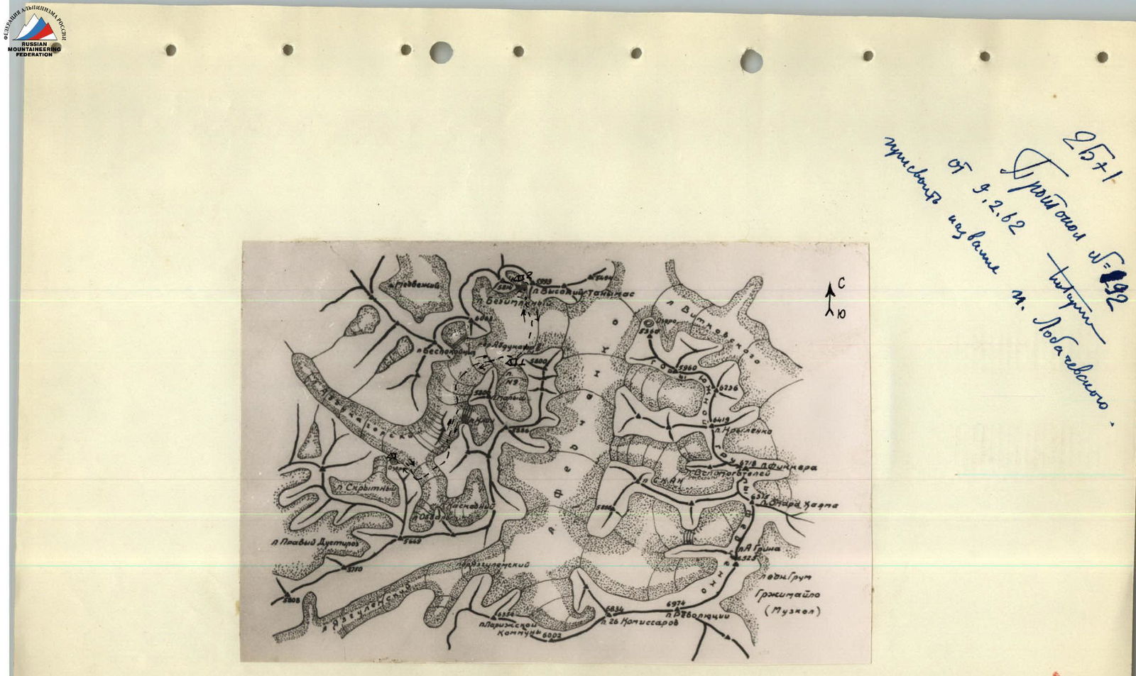
Map-scheme of the ascent area. 1, 2 — bivouacs