-
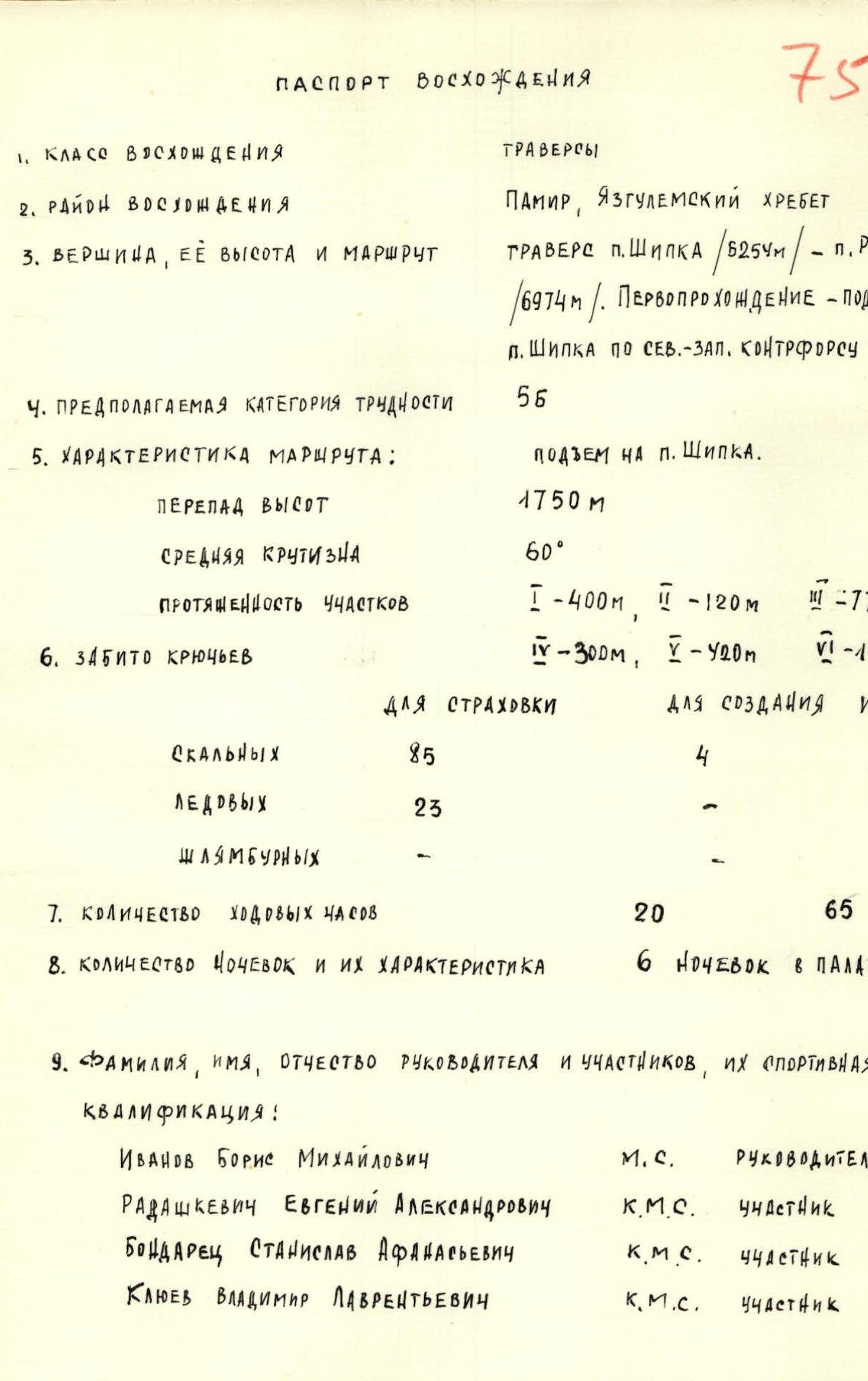
TEAM COACH – HONORED COACH OF THE USSR, MASTER OF SPORTS SIVTSOV Boris Grigorievich
-
DATE OF DEPARTURE ON THE ROUTE AND RETURN TO THE CAMP: 16.08.1973 – 23.08.1973.
Map-Scheme of the Ascent Area
§1. Brief Geographical Description
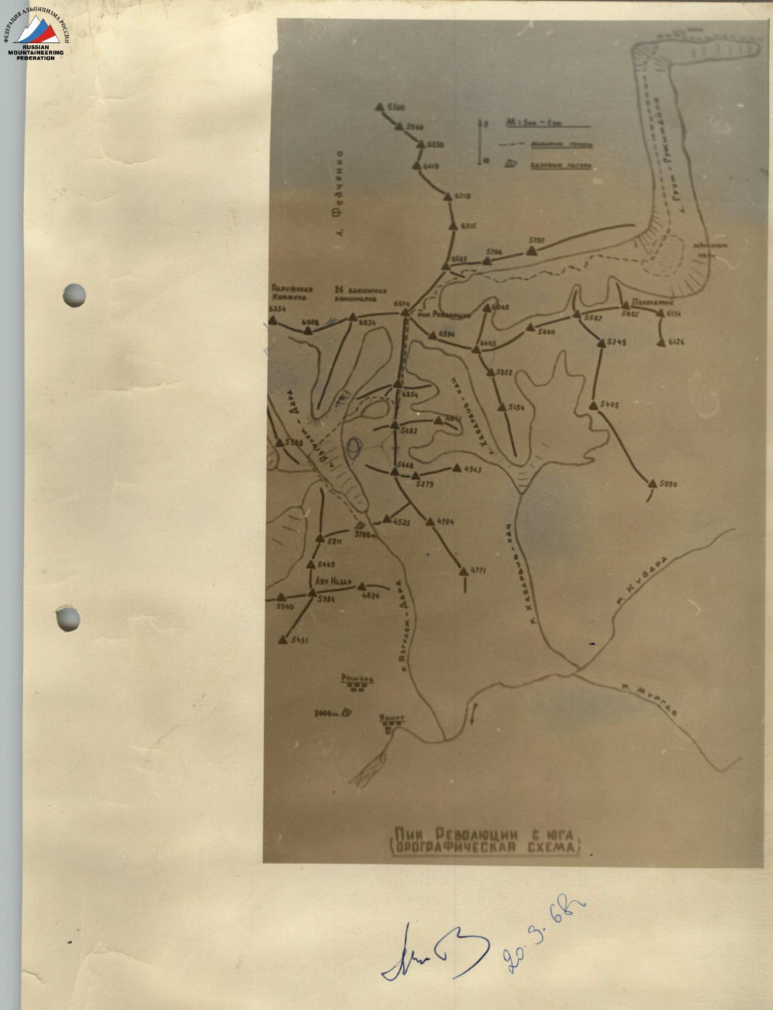
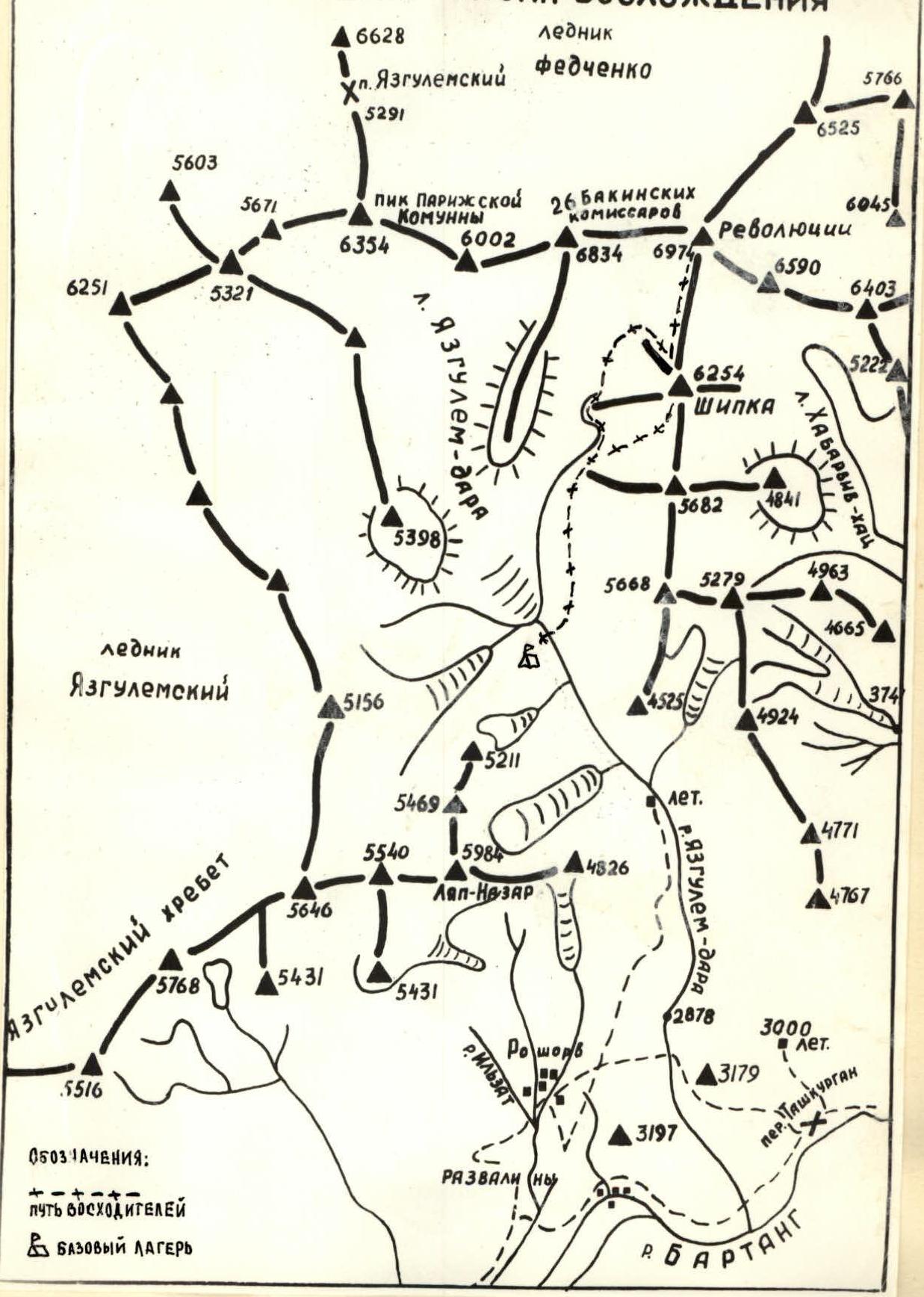
Peak Revolyutsii (6974 m) is located in the Central Pamir in the eastern end of the Yazgulemsky ridge. Together with its neighbors along the ridge:
- Peak 26 Baku Commissars (6834 m)
- Peak Paris Commune (6537 m) to the west, Peak Revolyutsii feeds the upper reaches of the Fedchenko glacier with the ice of its northern slopes. To the south, the walls of Peak 26 Baku Commissars and Peak Revolyutsii are washed by the Revolyutsii glacier, which is nourished by avalanches from the hanging glaciers of the southwestern slope of Peak Revolyutsii (the southern slope of Peak 26 Baku Commissars and the northwestern slope of Peak Shipka).
§2. Climbing Conditions
The area around Peak Revolyutsii – 26 Baku Commissars is one of the most inaccessible regions of the Pamir. The climbing object is separated from motorable roads by dozens of kilometers of rough terrain on all sides. Practically, organizing a base camp on Yazgulema-dara for an extended period to undertake several ascents is impossible without a helicopter.
The nearest settlement, kishlak Roshorv, is a day's journey from the base camp. All forms of communication, except for a postman, are absent. Even farther, along the Bartang River, lies the kishlak Sovnob with telegraph communication.
50 km upstream along the Bartang to Kudara and 90 km downstream to the kishlak Bartang, there is no motorable road; as of 1973, there was no pack animal traffic either, as the bridges had been washed away.
The weather is relatively stable but colder than in the Southwestern Pamir.
The prevailing wind is northeasterly.
The geological structure of the area is quite complex. The rock formations are mainly complex intrusive rocks with rare outcrops of granite, sandy-limestone schist, and marbleized rocks.
The alpinist exploration of the area is far from complete. Many peaks await their first ascenders. The map, especially southwest of the Khurdzhin pass, needs to be updated. Although 20 years have passed since the first alpine expedition entered the area, subsequent expeditions have been quite rare, primarily due to the inaccessibility of the region.
From the south, the first ascent of Peak Revolyutsii was made by army climbers in 1968, and Peak 26 Baku Commissars was climbed in 1969. A total of four expeditions were based here before us: two army expeditions in 1968 and 1969, a Tomsk expedition in 1969, and a "Trud" expedition in 1970.
On Peak Shipka, the following routes have been completed:
- Category 3B – combined – along the western counterfort with an exit to the northern ridge.
- Category 5A – combined – along the southern ridge with an exit to it via the southwestern counterfort.
- Category 5B – combined – along the southern ridge with an exit to it via the right western counterfort.
§3. Reconnaissance Sorties
On July 24-25, a group consisting of Ivanov, Bondar, Radoshkevich, and Klyuev set out under the southern wall of Peak 26 Baku Commissars, from where the route to Peak Shipka is clearly visible.
The objectives of the sortie were: a) to choose a path of ascent to Shipka; b) to observe the chosen route; c) to cache food and equipment at the start of the route; d) acclimatization.
As a result of two days of observation, they chose an ascent via the wall to the right of the icefall onto a gentle snow-rock ridge leading to the base of the steep northwest counterfort of Peak Shipka. To the right of the start of this route hangs a glacier (photo 2), and to the left is an icefall (photo 1).
§4. Organizational and Tactical Plan
The organizational and tactical plans were as follows: I. Organizational plan: The team participated as part of the Donetsk alpine club "Donbass" alpinade. The alpinade was conducted in two stages:
- gathering at the "Elbrus" alpine camp from June 22 to July 12.
- July 13 – gathering of participants in Dushanbe;
- July 16-20 – transportation of cargo and participants to the town of Rushan.
- July 20-22 – transportation of cargo and participants to the Yazgulem-dara glacier and organization of the base camp.
- July 23-31 – reconnaissance and acclimatization.
- August 1-25 – ascents.
The organizational plan was executed to the day. The expedition was provisioned with food until September 5. The expedition included a doctor (Radoshkevich E.A., Candidate for Master of Sports in alpinism).
Regular, uninterrupted radio communication was maintained with the town of Khorog, where the radio operators had a list of operational addresses.
Tactical Plan
The tactical plan included:
-
To complete the traverse Peak Shipka – Peak Revolyutsii – Peak 26 Baku Commissars – Peak Paris Commune, applying for primacy in the USSR.
-
Safety is ensured by a thorough study of the route, the nature and pattern of rockfall, and interaction with the team led by V. Rusanov, which was resting in the base camp after ascending Peak 26 Baku Commissars.
-
Communication with V. Rusanov's team in the base camp is maintained via "Vitalka" radios. The base camp communicates with the "Big Land" twice a day using an RSO-30 radio station.
-
The team is provisioned with food for 15 days at a rate of 600 grams per person per day.
-
The following equipment is taken on the route: a) main rope 2 × 40 m. b) auxiliary rope 1 × 40 m. c) rock pitons, titanium and steel – 42 pieces. d) ice pitons, titanium – 8 pieces. e) carabiners, titanium – 26 pieces. f) drill pitons and drills – 20/2 pieces. g) hammers – 2 pieces. h) ice axes – 2 pieces. i) ice picks – 2 pieces. j) Pamir tents – 1 piece. k) primus stoves – 1 piece. l) pots – 2 pieces. m) "Vitalka" radio station – 1 piece. n) crampons – 2 pairs. o) spare rope – 40 m.
Adjustments made to the tactical plan. By decision of the expedition's coaching council, the first ascent target became Peak Lyap-Nazar, its northeastern wall.
After the ascent of Lyap-Nazar, part of the group could not, for various reasons, proceed with the traverse Peak Shipka – Peak Revolyutsii – Peak 26 Baku Commissars – Peak Paris Commune. Four people remained in the group. For four people, this traverse would have been very challenging, considering the 10-day ascent of Lyap-Nazar, and there was also a lack of time, as the expedition was nearing its end.
Therefore, the traverse of Peak Shipka was chosen with an ascent via the Northwest counterfort (first ascent) followed by an ascent to Peak Revolyutsii via the 0.3 counterfort of the Southern rib, and descent via Peak Shipka along the Category 3B route.
§5. Composition of the Assault Group
- Ivanov B.M. – Master of Sports, captain, Yenakiyevo, "Avangard"
- Radoshkevich E.A. – Candidate for Master of Sports, Donetsk, "Spartak"
- Bondar S.A. – Candidate for Master of Sports, Donetsk, "Burevestnik"
- Klyuev V.L. – Candidate for Master of Sports, Donetsk, "Avangard".
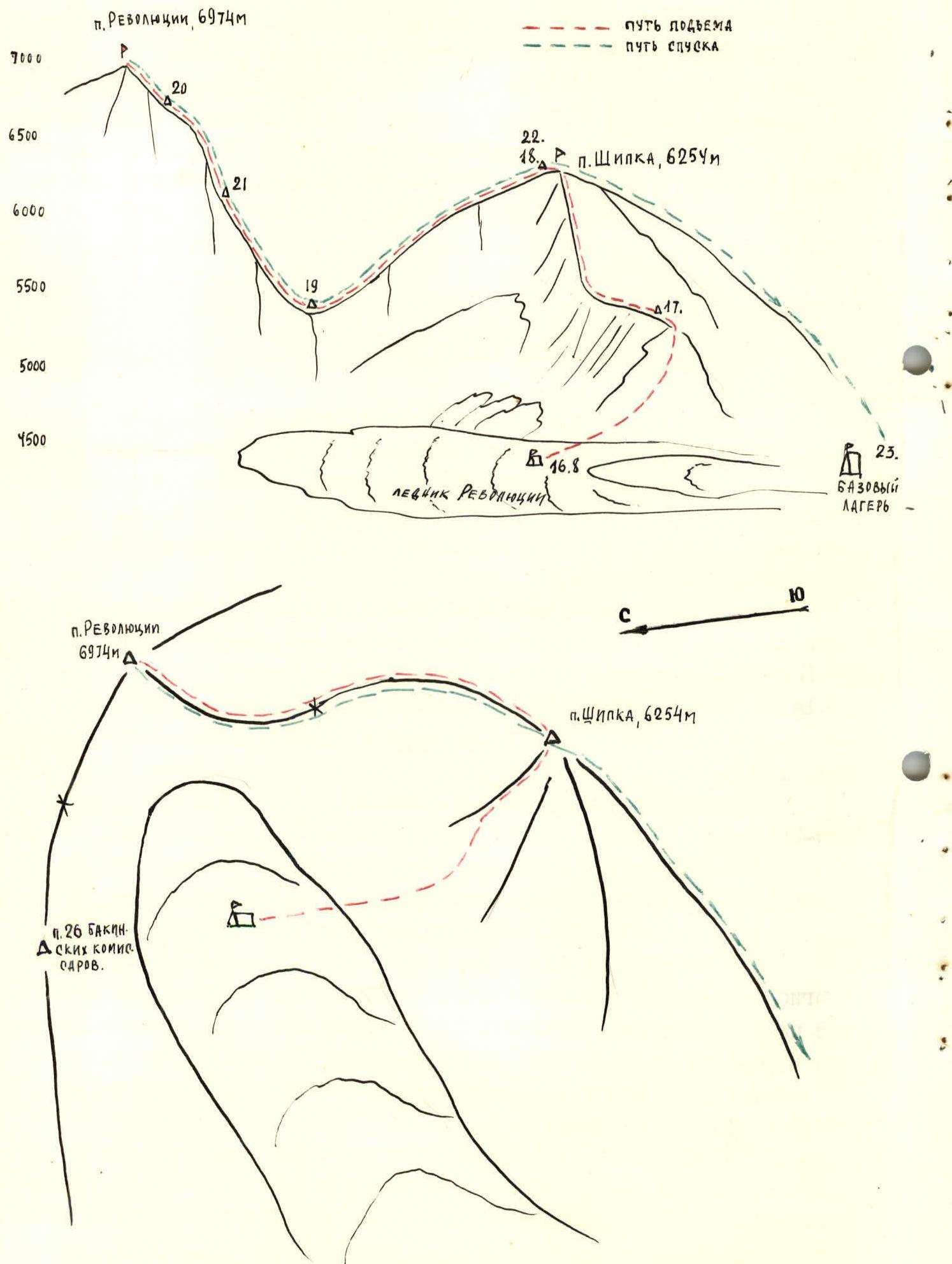
§6. Route Progression
August 15. Departure from the Donetsk expedition's base camp from the helicopter pad. Overnight on the Revolyutsii glacier. The wall along which we are to ascend to the gentle snow-rock ridge is clearly visible (photos 1-2-1).
August 16. We depart on the route without waiting for sunrise, as we need to cross the frozen waterfalls from left to right at a quick pace before they "wake up." In photo 1, the first and second waterfalls are visible from left to right; unfortunately, the third and fourth are not visible. After the second waterfall, we climb a 40-meter wall at 90° directly upwards. The path then proceeds upwards to the right (quite steep, 60–70°) through broken rocks (slabs, blocks, etc.) to a shoulder, which is the end of the gentle snow-rock ridge coming from the base of the northwest counterfort. Along the sharp rocky ridge of the shoulder (150–200 meters), we reach the snow and, after a short distance, establish a good bivouac on a rocky outcrop. The height is approximately 5400 m, at the level of the col between Peak Shipka and Peak Revolyutsii. We ascended approximately 800–900 meters.
August 17. Departure at 8:00. Cold. We ascend along the gentle snow-rock ridge to the base of the northwest counterfort. The passage of the counterfort takes 12 hours (strongly broken rocks, difficult to establish reliable belays, average steepness 65°). In the middle part of the counterfort, we pass very difficult 4 rope lengths of a rocky couloir with a steepness of 70–80°. The exit to the rocky plateau of the summit occurs in the evening, in twilight, along the snow-ice termination of the counterfort (8 rope lengths, steepness 50°).
August 18. Departure at 9:00. We move along the summit ridge of Peak Shipka towards Peak Revolyutsii over snow and ice. The descent to the col along the steep ridge follows the boundary between snow and rock. Overnight on the col (photo 3).
August 19. Departure at 8:00 onto the Southern rib of Peak Revolyutsii. The snow-ice rib (photo 4) transitions into a rocky counterfort. Height 6500 m. The snow is corniced. Overnight, very strong wind, cold.
August 20. Departure at 9:00, we proceed to the summit, bypassing the army climbers' campsite near the last rocks before the snow-ice slopes of the summit. We ascend these slopes to the summit cairn. We replace the note, take photos, and quickly descend to our tent. Evening catches us at the start of the descent along the snow-ice ridge.
August 21 and 22. The descent proceeded along the ascent route, and the descent from the summit of Peak Shipka followed the Category 3B route.
§7. Technical Passage of Complex Sections and Overall Assessment of Participants' Actions
The entire route was mostly climbed using free climbing, and only at key points (on Peak Shipka via the northwest counterfort) were ladders used (to the right of the second waterfall, on the rocky shoulder, in the middle part of the counterfort, photo 1-2-1).
The lead climbers on the rocks, alternating with lightened backpacks, were Ukrainian champions of 1972, Candidates for Master of Sports Radoshkevich and Bondar; on snow – Ivanov and Klyuev.
The ascent took place in a good working atmosphere, in a spirit of friendship and mutual understanding. All participants coped with the tasks set by the tactical plan and their physical capabilities.
§8. Overall Characterization of the Route
The route taken via the Northwest counterfort is perhaps the shortest route to Peak Shipka (6254 m).
The section of the route from the overnight on August 16 to August 17 is a fairly steep, broken wall of 60–70°, dangerous in terms of rockfall from the upper belt of rocks. There is no place to set up a tent on this wall. An overnight on it could be unpleasant; the wall is approximately 700 meters long.
The second section of the ascent on Peak Shipka is the northwest counterfort itself, 700–800 meters high. The rocks are fragile and require extreme caution. As with the first section, there is no place to set up a tent.
The team unanimously agrees that, in terms of technical difficulty, steepness, and length of the sections, the ascent to Peak Shipka via the northwest counterfort should be classified as a Category 5B route.
TEAM CAPTAIN B. IVANOV
TEAM COACH B. SIVTSOV