- Climbing category — altitude-technical
- Climbing region — Yazgulemsky ridge
- Peak Shipka, 6254 m, central buttress of NW wall
- Proposed difficulty category — 5B
- Route description Height difference — 2154 m, average steepness — 45°, average steepness of wall section — 60°, length of sections: R0 — 0; R1 — 500 m; R2 — 1550 m; R3 — 710 m; R4 — 305 m; R5 — 150 m.
- Pitons driven: for belaying, rock — 96, ice — 0, bolt — 0 for creating belay anchors — 8
- Total hours of climbing — 42
- Number of bivouacs — 4, suitable for one tent.
- YAKOVLEV Gennady Semyonovich — Candidate Master of Sports — team leader SHUMIKHIN Gennady Ivanovich — Candidate Master of Sports, PRUSOV Gennady Vladimirovich — Candidate Master of Sports, SHAKALO Valery Matveyevich — Candidate Master of Sports.
- Team coach — Master of Sports KHATSKKEVICH Igor Georgiyevich.
- Date of departure on the route — August 2, 1977 Date of return — August 8, 1977
GEOGRAPHICAL LOCATION
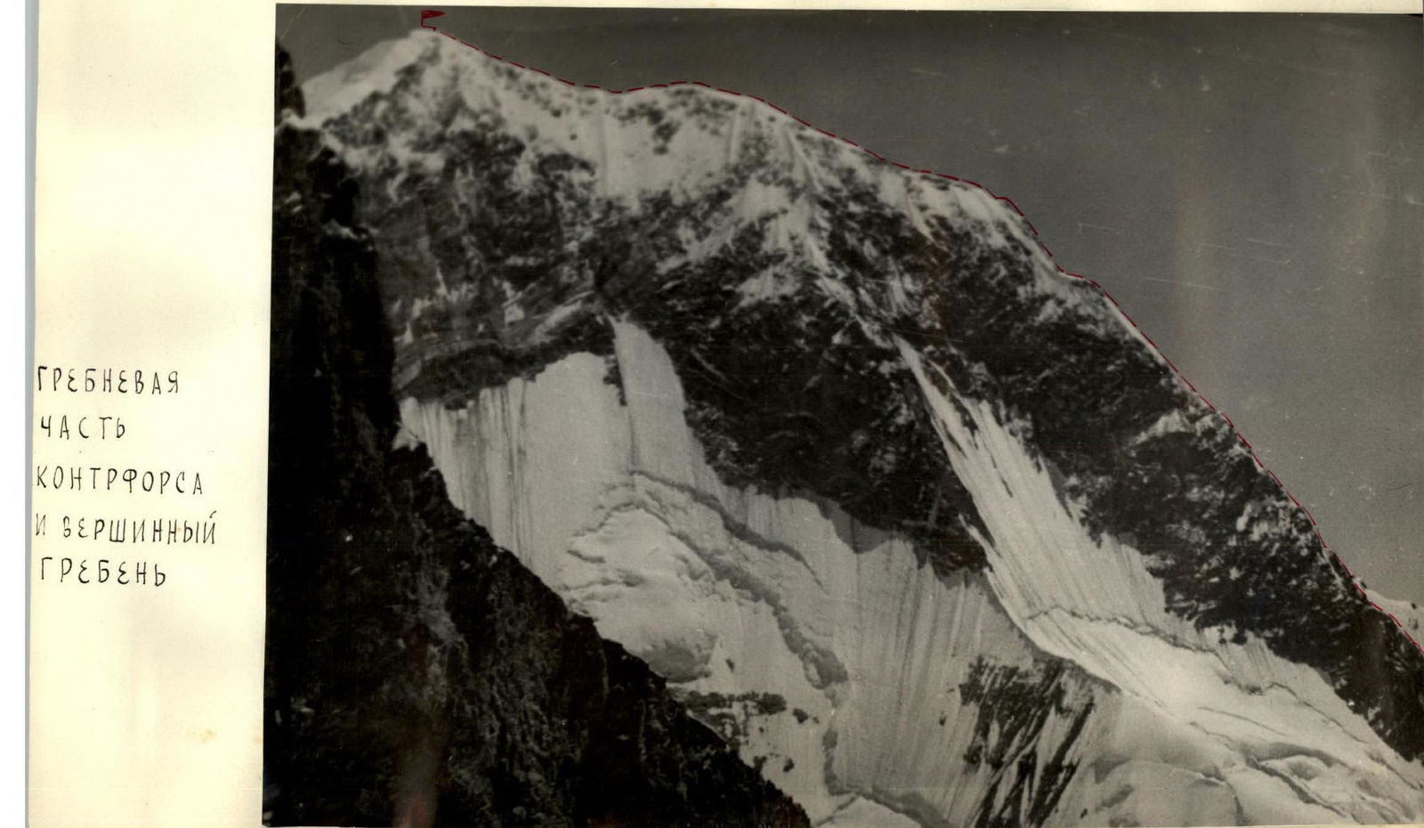
Peak Shipka is located in the Yazgulemsky ridge in the Pamir, near Peak Revolyutsii. Peak Shipka is a powerful massif with a height of 6254 m, located between Peak Revolyutsii and Peak 50th Anniversary of the Armed Forces of the USSR. The northwest wall of Peak Shipka drops down with three buttresses, separated by three powerful ice falls hanging from the glacier, which divides the NW wall roughly into two equal parts vertically. The right buttress is the most logical, as it almost directly leads to the pre-summit ridge, but the lower part of the right buttress is entirely overlapped by hanging ice falls, posing an extreme danger, and the route cannot be recommended. After observing the NW wall, the group gave preference to the central buttress. The lower part of it is a powerful triangular rock wall with a height of approximately 600 m and an average steepness of 60°. The lower wall of the buttress connects to the upper wall with a practically horizontal rock ridge, slightly rising above the ice fall. The upper wall, with a height of 500 m and an average steepness of 60°, turns into a snow-ice ridge with separate rocks, leading to the summit ridge. A characteristic feature of the upper wall of the buttress is that it is divided from top to bottom by a deep couloir.
TEAM COMPOSITION
- Yakovlev G. S. — Candidate Master of Sports — captain of the team from Zarechny, Sverdlovsk region
- Shumikhin G. I. — Candidate Master of Sports — "
- Prusov G. V. — Candidate Master of Sports — Moscow
- Shakalo V. M. — Candidate Master of Sports — Kiev
PREPARATION FOR THE ASCENT
All team members were simultaneously registered as instructors at the "Dzhailyk" alpine camp, preparing for the ascent of Peak Revolyutsii for the USSR championship. This determined the team's preparation focus. In June-July, working as instructors at the camp, team members made several joint training ascents in the Caucasus, including the ascent of Cheget-Tau-Gana via a 5A category route and the ascent of Dzhailyk via the eastern wall, a 5B category route. Immediately before ascending Peak Shipka, they made an ascent of Peak 50th Anniversary of the Armed Forces of the USSR, as well as several acclimatization outings to scout the area and transport gear and supplies to the area of Peak Revolyutsii and Peak Shipka. All this allowed team members to achieve the necessary level of fitness. Additionally, during these outings, they observed the NW wall of Peak Shipka, made necessary sketches and photographs, finally chose the route, and developed an approximate tactical plan for the ascent.
TACTICAL ASCENT PLAN
After discussing the results of observing the wall and confirming the route's sufficient safety and seriousness, the team adopted the following tactical plan for the ascent:
- Bivouacs were planned in the middle part of the lower and upper walls of the buttress, as well as at the foot of the upper wall and on the pre-summit ridge.
- Due to the presence of steep sections on the wall, galoshes were included in the gear list for the lead climber, and a 60 m rope was included for pulling up backpacks.
- Since the wall begins to receive sunlight quite late, it was deemed reasonable to start on the route no earlier than 8:00-9:00, but to work on the route as late as possible in the evening, i.e., until 18:00-19:00. Additionally, several potential bivouac sites were visible on the wall, so the tactical plan did not allocate much time for organizing bivouacs in the evening.
- The lower wall was decided to be ascended on its right part, as the route became more logical and closer to vertical. On the left and central parts of the wall, rock overhangs were visible, and the group would have had to traverse the wall to bypass these overhangs, which would have taken more time and been less safe. Moreover, during the observation, it became clear that the right part of the wall was less prone to rockfall.
ASCENT DESCRIPTION
On August 3, at 9:00, the group departed from their bivouac under the wall and began the ascent. The start of the route is located in the right part of the wall, 40-50 m to the left of the avalanche cone. The initial ascent is directly upwards via несложным разрушенным скалам плитообразного характера with a steepness of 50-60°. The general direction is towards a characteristic landmark — a large ledge of yellow smooth rocks. After 60 m from the start, the route approaches a vertical inner corner 15-20 m high. Complex climbing in galoshes with the use of jammers and pulling up backpacks. Then 60 m of несложных разрушенных скал with a steepness of 45°, leading to the base of the yellow ledge. A small platform. The ledge is bypassed on the right via a 40 m vertical inner corner with some overhang in the upper part. Difficult climbing in galoshes and pulling up backpacks. Then a 15 m vertical smooth wall of monolithic rocks with limited handholds. Pulling up backpacks. After the wall, movement continues up a large inner corner. In the upper right part of the inner corner, a small platform. R0 control point. The group stopped for the night at 17:00, organizing a bivouac site and further processing the route. August 4. Departure at 9:00. From R0 bivouac, the group ascended directly upwards via плитообразным скалам for 70 m with a steepness of 60-65°. Then an inner corner 25 m high. Difficult climbing. Exit onto a wide ledge. From the ledge, ascent via a smoothed inner corner 20 m high with overhang and limited handholds. Pulling up backpacks. Movement continued via несложным скалам with a steepness of 50°, and after 40 m, along a narrow ledge to the right, exiting onto a small platform. From the platform, overcoming a 30 m, 80° smooth плитообразной стенки with artificial footholds. Exit onto a wide ledge, along which movement continued to the right. By traversing the slope via несложным скалам 40 m, then via a wide 80 m couloir directly upwards. Simultaneous movement with belaying through rock outcrops. Ascent to the right-upwards 15 m via large rock blocks, and then 15 m vertical wall with a crack. Difficult climbing in galoshes and pulling up backpacks. Then upwards-to the right 120 m via very разрушенным зернистым скалам with a steepness of 50°. Movement was extremely cautious due to loose handholds and limited opportunities for piton placement. Exit onto a large rock plateau before the upper tower of the lower wall. The tower is bypassed on the left via a 20 m rock wall of medium complexity. Exit onto a practically flat ridge leading to the base of the upper wall. The group stopped for the night under the wall at 20:00. The upper wall is divided by a wide couloir from top to bottom. Movement is mainly along the ridge to the left of the couloir. August 5. Departure at 10:00. The first rock pitch 50 m high with a steepness of 70° is ascended on the left via rocks of medium complexity with натёчным льдом. The next rock pitch 60 m high with a steepness of 65° is ascended directly into the "face" of rocks of medium complexity. Then a section of wall 40 m high with a steepness of 80°. Difficult climbing with the use of artificial supports. Exit onto a small snow ridge. Then 50 m of несложных разрушенных скал, leading to a platform. At 18:00, the group stopped for the night. R1 control point. August 6. Departure at 10:00. Movement continued directly upwards along the ridge. Strongly разрушенными скалами of medium complexity with two 10-15 m vertical smooth walls. After 75-80 m, exit onto a platform. A vertical wall 25 m high. Difficult climbing and pulling up backpacks. Exit onto a wide ledge, and after 30 m, approach under a 40 m wall with a steepness of 70-75°. Rocks are strongly разрушены. Difficult climbing. Exit onto a ledge. From the ledge, bypassing the wall on the right, exit via разрушенными скалами of medium complexity onto a ridge. After 100 m, movement along the ridge led under a 50 m wall with a steepness of 80°. Difficult climbing. Exit onto the ridge part of the buttress. 30 m below to the right, a convenient platform. The group stopped for the night at 19:00. August 7. Departure at 9:00. Again, ascent onto the ridge and movement along simple and medium complexity rocks directly upwards along the ridge. The first rock obstacle on the ridge is overcome "in the face." Rocks are of medium complexity with a steepness of 60° and a length of 50 m. Then a snow section with separate rocks. The next two rock obstacles do not present technical difficulties and are overcome "in the face" with mutual belaying. The exit onto the pre-summit ridge is a snow-ice pitch with a steepness of 50-55° and a length of 300 m. The first 200 m are overcome via твёрдому фирну with careful belaying through an ice axe. Then a small traverse to the right along an ice section towards separate large rocks frozen into the ice, and exit onto the pre-summit ridge. Leaving their backpacks behind and ascending several powerful snow pitches, the group reached the summit at 15:00, the highest point of which is a large snow dome dropping off with a cornice to the southeast. The control point is set up slightly below the highest point on the rocks of the northern side. Descent from the summit followed a 5A category route to the Shipka pass. After organizing another overnight stay on the descent, the group descended to the base camp of the expedition on August 8.
TABLE
Main characteristics of the route
Route of ascent — Peak Shipka (central buttress of NW wall) Height difference of the route — 2164 m Including most complex sections — 1100 m Steepness of the wall section of the route — 60°
| Character of section | Difficulty | Condition | Pitons | |||||||
|---|---|---|---|---|---|---|---|---|---|---|
| Designation | Average steepness, ° | Length, m | Character of relief | Rock | Ice | Bolt | ||||
| Date | Weather conditions | |||||||||
| August 3 | R0–R1 R1–R2 R2–R3 R3–R4 R4–R5 | 60 90 45 90 60 | 70 20 60 55 40 | Плиты Внутр. угол Внутр. Стенка Внутр. угол Внутр. угол | IУ y III УI IУ | Разруш. Монолит Разруш. Монолит Камнеопасный | Clear. Cold wind. | 5 4 2 II(III) 2 | - - - - - | - - - - - |
| August 4 | R5–R6 R6–R7 R7–R8 R8–R9 | 65 90 50 80 | 70 45 40 30 | Плиты Внутр. угол Внутр. угол Гладкие плиты | y У IУ УI | Монолит Заглаж. скалы Разруш. Монолит | Clear. Cold wind. | 5 ІО(II) 2 7(II) | - - - - | - - - - |
| R9–R10 R10–R11 R11–R12 R12–R13 | 40 80 50 20 | 120 30 120 500 | Кулуар Стена Гребень | III y IУ II | Разруш. Монолит Разруш. Разруш. | Clear. Cold wind. | Belaying through outcrops 5 5 Belaying through outcrops | - - - - | - - - - | |
| August 5 | R13–R14 R14–R15 R15–R16 R16–R17 | 70 65 80 45 | 50 60 40 50 | Скалы Стенка Плита | IУ У УI III | Натёчный лёд Разруш. Монолит Разруш. | Clear. Cold wind. | 3 3 6(I) 2 | - - - - | - - - - |
 | R17–R18 R18–R19 R19–R20** R20–R21 R21–R22 | 90 90 75 40 80 | 30 25 40 100 50 | Стена Стена Стенка Гребень Стена | y УI IУ III y | Монолит Монолит Разруш. Разруш. Монолит |  | 4 4 5 2 9 | - - - - - | - - - - - |
 | R22–R23 R23–R24 R24–R25 R25–R26 R26–R27 | 40 60 55 40 | 130 50 300 | Гребень Стенка Гребень Взлёт Взлёты | III IУ III IУ III | Разруш. Блоки Комбин. Снег, лёд Фирн |  | 3 3 Belaying through outcrops 3 Belaying through ice axe |  | - - - - - |
The route to the summit took 42 hours of climbing in relatively favorable weather conditions, except for a piercing cold wind. The route is fairly logical and relatively safe. The presence of convenient bivouac sites is also an advantage. The ascent was a good learning experience for Prusov G. and Shakalo V., who had not previously climbed peaks above 6000 m. They successfully completed the task. The route is primarily rock climbing, but in the upper part, where the altitude begins to take its toll, it requires demonstrating the ability to overcome complex snow-ice terrain. The route utilized a variety of pitons, from thin leaf-shaped ones to wedges 4-10 mm thick. To ensure communication, the group had 2 radios:
- "Nedra" for communication with the base camp;
- "Vitalka" for communication with the group on Peak Revolyutsii. It is thought that subsequent expeditions ascending via this route could use the same means for communication with groups on Peak Revolyutsii or Peak 26 Baku Commissars, as Peak Shipka is a barrier to direct radio communication between these peaks and the traditional base camp location. The ascent of Peak Shipka will also serve as good training before attempting more complex routes in the area, which require the most serious preparation. In terms of complexity, the route on Peak Shipka is practically on par with the route via the western edge of the northern wall of Peak Marxa, a 5B category route.
MAP-SCHEME
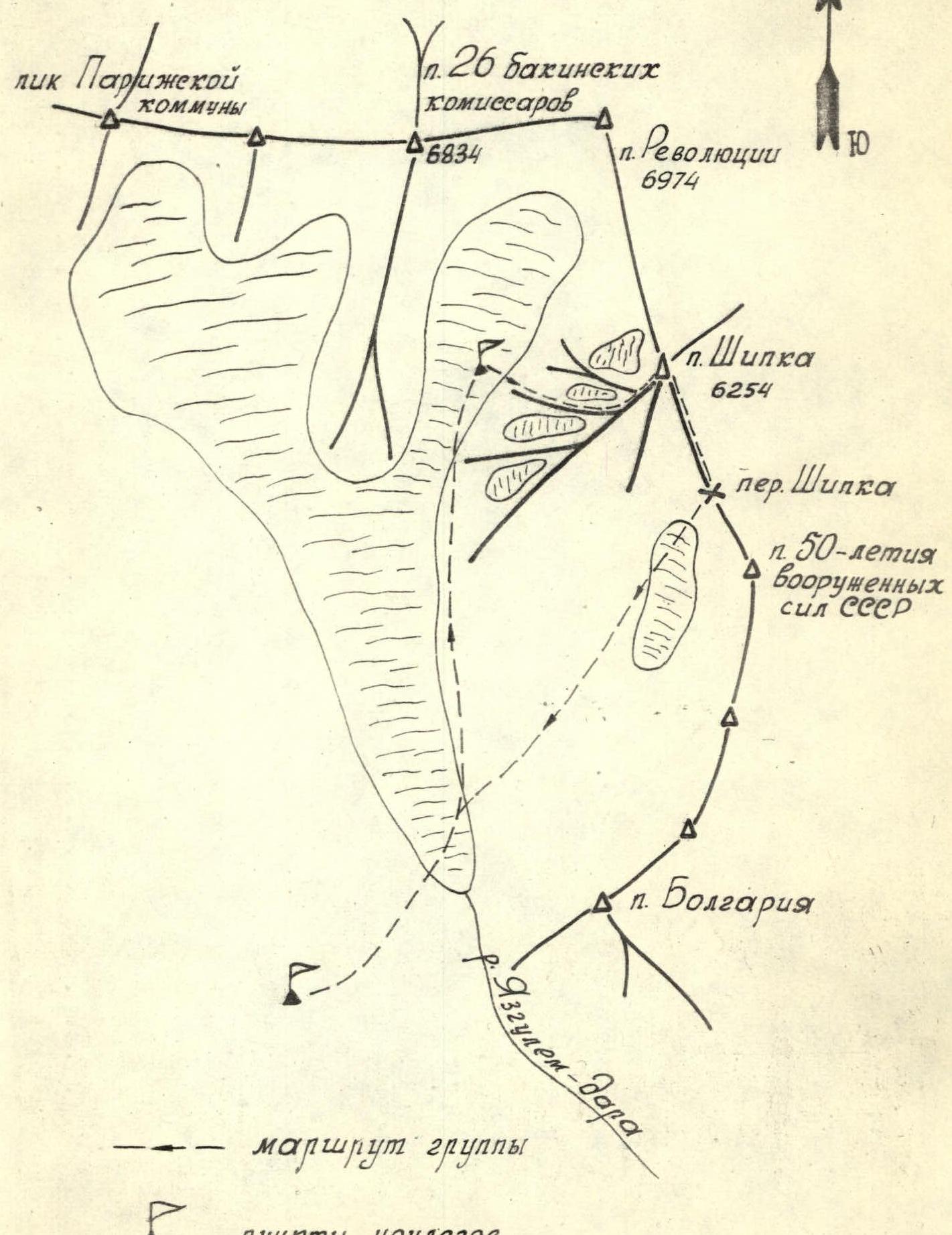
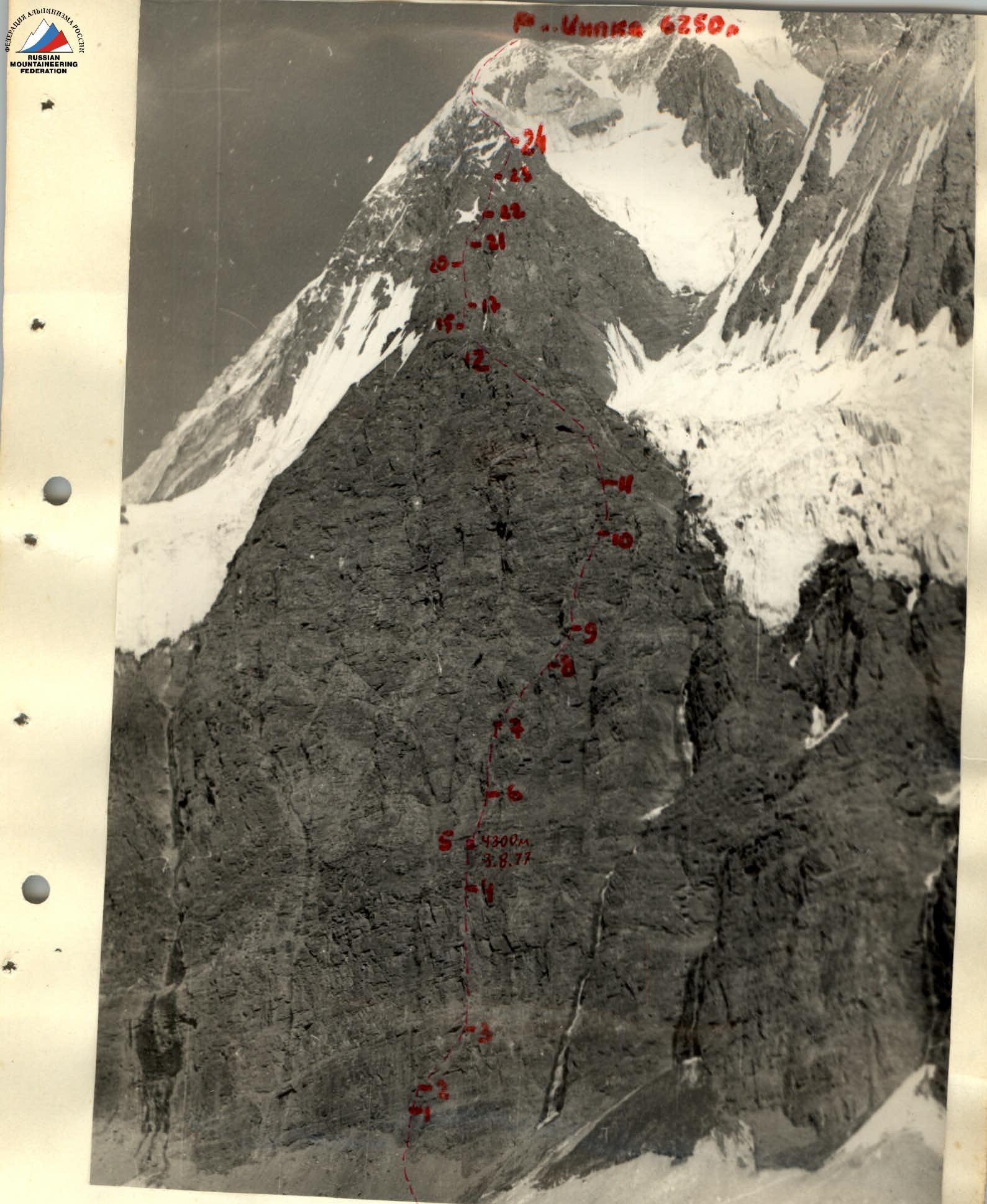
CENTRAL BUTTRESS OF NW WALL
BIVOUAC, R0 CONTROL POINT
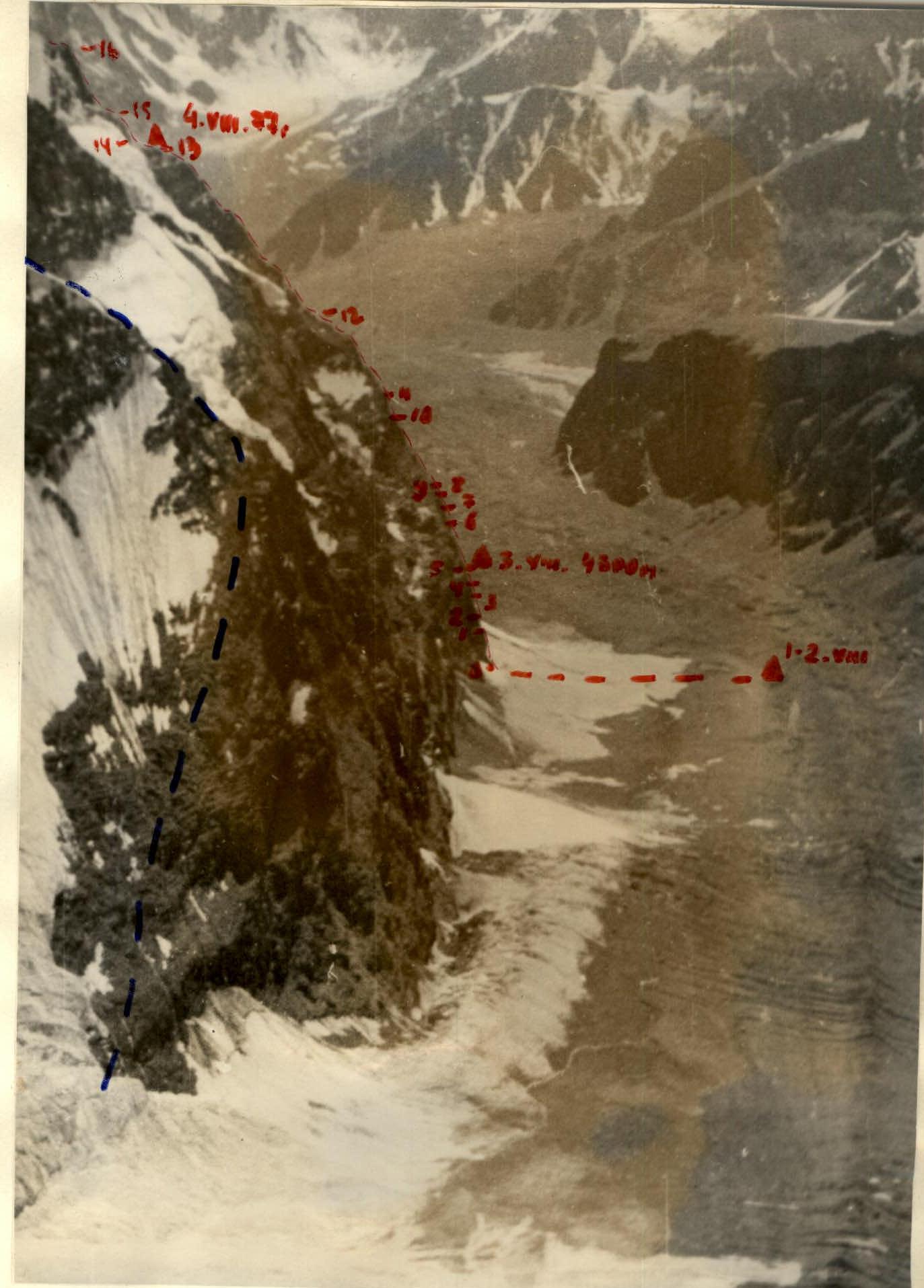
LOWER WALL (PROFILE)
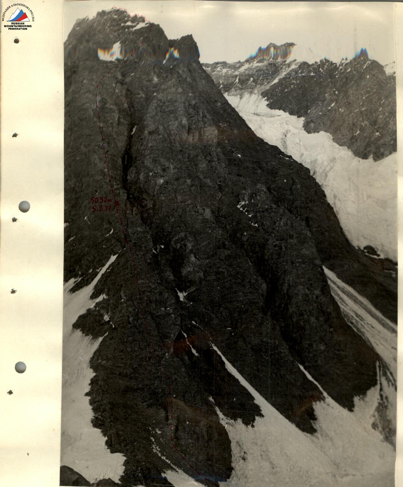
UPPER WALL (SECTIONS R13–R24)