
Ascent to Peak Shipka (6247 m) via the Southwest Ridge
Central Council of DSO "Zenit" 1970
Brief Geographical and Geological Characteristics of the Peak Shipka Area Peak Shipka (6247 m) is located in the central part of the Pamir Mountains, within the Gorno-Badakhshan Autonomous Region of the Tajik SSR. Along with the peaks:
- Peak 26 Baku Commissars (6834 m),
- Peak October Revolution (6974 m),
- Peak Paris Commune (6002 m), Peak Shipka encloses the Yazgulem-Dara valley, at the head of which lies the eponymous glacier, stretching over 15 km. On geographical maps, the name of the glacier and valley is incorrectly printed with "E" instead of "Ё", though this is a local name and is pronounced as YAZGULЁM-DARA.
The Yazgulem-Dara valley is a small branch of the giant Bartang valley. The Bartang valley is difficult to traverse, with no vehicular road and trails that are essentially "improved" ravines. Therefore, caravan travel through the Bartang and Yazgulem-Dara valleys is highly problematic.
Geologically, the Peak Shipka area represents an Alpine geosynclinal region. The peak is situated at the junction of the Yazgulsky and Vanchsky ridges, where the latitudinal and meridional ridges of the Pamir Mountains intersect. It is composed of magmatic rocks from the Upper Paleozoic and Mesozoic eras:
- crystalline and clay schists,
- limestones,
- granites.
The snow line is at an altitude of 4000–4200 m, and the peak has significant glaciation.
Ascent
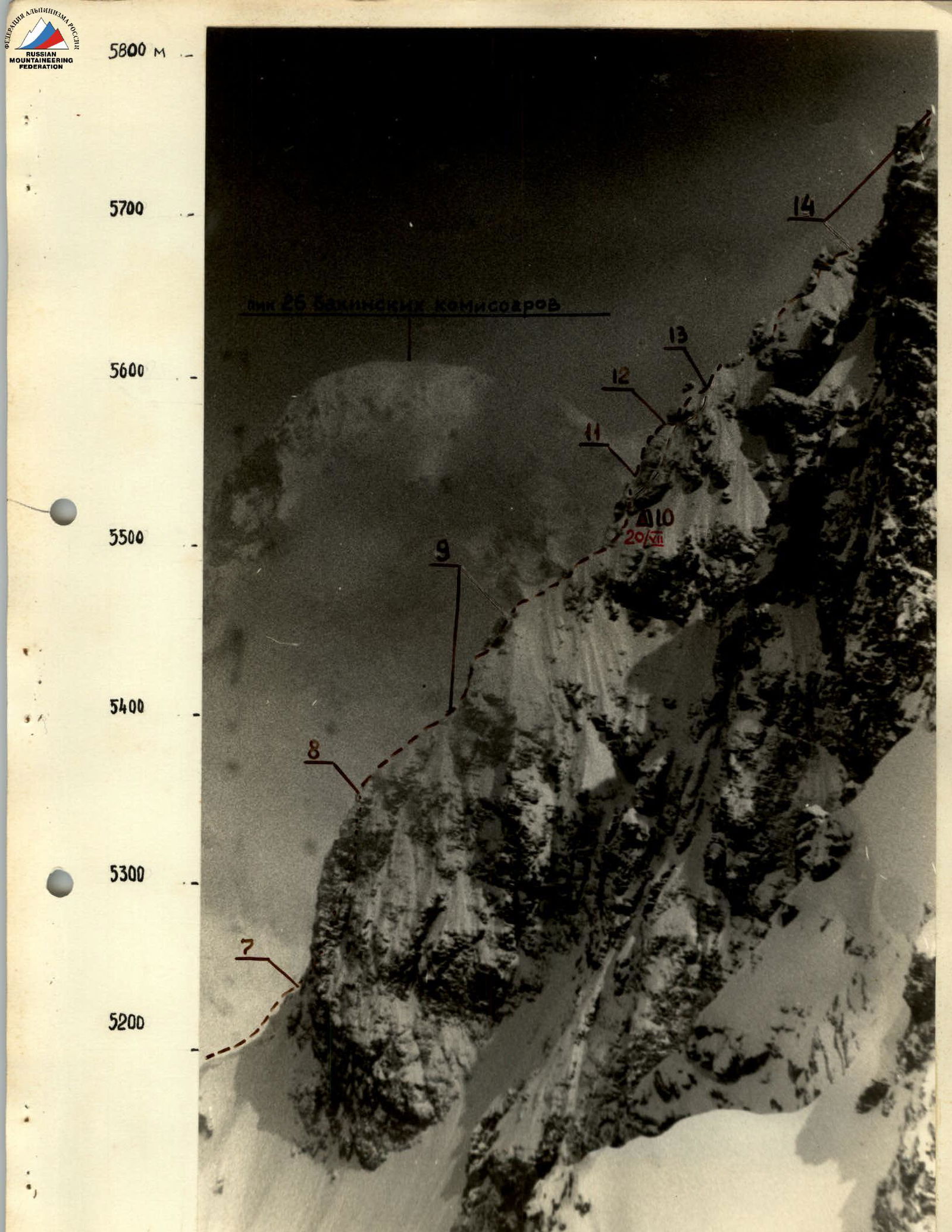
July 15. We ascended along the trail, crossed the Yazgulem-Dara glacier in its lower part, and approached the glacier hanging from the southwest walls of Peak Shipka via grassy slopes and scree.
During preliminary reconnaissance and study of possible ascent routes to the glacier, two options were considered:
- To the right, between the rocks and the glacier - via a snowy couloir;
- Up the steep snow in the middle part of the glacier, broken by rock outcrops.
Initially, the first option seemed more preferable, but upon closer inspection, it was found to be prone to rockfall from the southern ridge slopes. The group chose the second ascent option and set up a bivouac under the slopes supporting the middle part of the glacier.
July 16. In the morning, we ascended up the steep snow, bypassing the rock massif. Protection was provided through pitons in the rock outcrops. At the top of the rock massif, there is a large ledge. From the ledge, two ropes were thrown up to the right, almost traversing. The first climber wore crampons and chopped steps. Protection on the second rope was via an ice screw.
We reached a small plateau on the left side of the glacier (in the direction of travel). From here, we ascended again - 2–2.5 ropes up steep ice - and reached another plateau. The plateau had closed crevasses, requiring us to crawl across without backpacks on snow bridges. Backpacks were pulled up using a rope.
Further, we ascended towards the right bank of the glacier. On steep sections, the first climber wore crampons and chopped steps. Protection was through pitons.
At 15:00, we reached the upper plateau of the glacier. The exit to the ridge leading to the western buttress was marked by huge overhanging cornices on the right and rock walls. However, ascending to the ridge via steep snow was deemed dangerous due to the risk of avalanche. We set up a bivouac. At night, wind picked up, and occasionally, graupel hit the tent roof.
July 17. Bad weather. Strong wind. We decided to wait it out. However, during a brief window, a team of two went to scout the route - to determine the true condition of the slope, its steepness, and to possibly fix ropes. After 2.5–3 hours, the team reached the rocks, fixed ropes, and descended back to the bivouac.
July 18. The weather was relatively good in the morning, with clouds covering the sky but with large gaps. We set out on the route. First, we crossed a bergschrund via a snow bridge, then ascended steep snow. The ropes left by the scouting team were unusable due to deep snow. Then, there was a change in the lead climber. Protection was through ice axes and ice screws driven into the ice in dug-out holes.
In the upper, steepest part, we used the ropes fixed the previous day. Movement along the rocks was on snow, with protection through rock pitons - one rope.
The final 7–8 meters to the ridge were quite unpleasant, with hard, metal-like ice under a thin layer of snow.
The weather quickly deteriorated. Graupel started falling. Strong gusts of wind. Visibility reduced to 80–100 m. The first team of two moved further along the ridge but returned as they approached the ridge. Visibility reduced to 40–50 m. Beyond a rock pitch, a small, steep ice mulde was visible. We decided to dig a platform there, as there was a risk of being caught in bad weather on the sharp rock ridge.
About 3 hours of heavy work with ice axes. We set up tents. The bad weather intensified at night.
July 19. The morning brought no change in the weather. Moreover, the wind strengthened, and gusts threw dry, fine snow. We had to wait again. If the weather didn't improve the next day, we would prepare for descent.
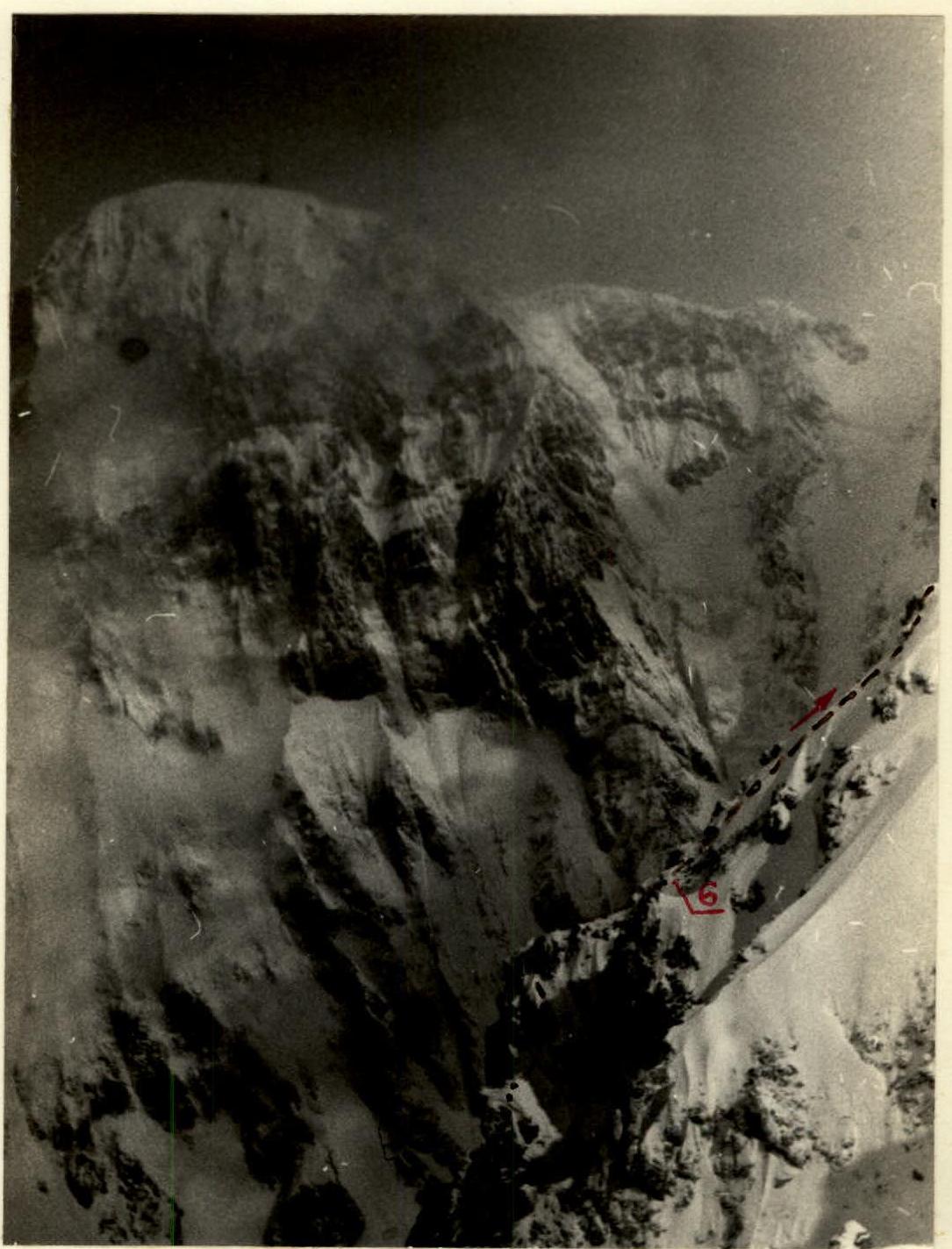
July 20. However, in the morning, it was relatively calm. Snowfall had stopped during the night. At 9:00, we headed up. The first two rock massifs on the ridge were bypassed on the left via icy ledges. The rocks were of medium difficulty but were covered in flow ice and snow, making them quite unpleasant to navigate. Further, the ridge became jagged, with large cornices, ending in a steep pitch, essentially turning into a buttress. Climbing the pitch via rocks was generally of medium difficulty, with short sections being more challenging. Protection was through rock outcrops and pitons. A small section of the sharp ridge with cornices (R6–R7) and an exit under a steep wall followed. Directly up the wall, then a short traverse to the right, and into a steep internal corner bounded on the left by a large overhanging "boulder". Climbing was tense, complicated by loose, large, thin rocks. Protection was through pitons. After 40 m, a small ledge with an overhanging rock provided shelter. No more than 3 people could gather on the ledge and take cover under the overhang from potential rockfall. From the ledge, another 40 m of difficult climbing followed (R7–R8). The first climber went without a backpack. The sky was cloud-covered, with occasional snowfall. The wind was weak, but the temperature had clearly dropped.
After the wall, a section of the rock ridge followed, technically not complex,
but requiring careful tracking of the ridge line to avoid overhanging cornices on the glacier side (R8–R9). A pitch of steep, loose rocks followed. Climbing was of medium difficulty. The order of climbers was strictly maintained due to numerous "live" rocks. Further, the ridge became jagged and snow-ice-covered, with rock outcrops. Traversing the ridge where rocks outcropped was very challenging, requiring psychological endurance due to the steep drops on both sides of the buttress (R9–R10).
Throughout the route, not a single suitable spot for a tent bivouac was found. Finally, just before darkness fell, we found a small snow-covered ledge - a gradually disappearing continuation of the ridge on the wall.
We organized the night as follows:
- One tent was set up relatively stably, with about 2/3 of its floor on the ledge.
- The second tent was suspended above the ledge, with its floor on the snow, allowing us to sit with our legs dangling.
We managed to cook soup and tea by "tucking" the tent walls with gear and making use of the available space.
The weather was relatively calm at night.
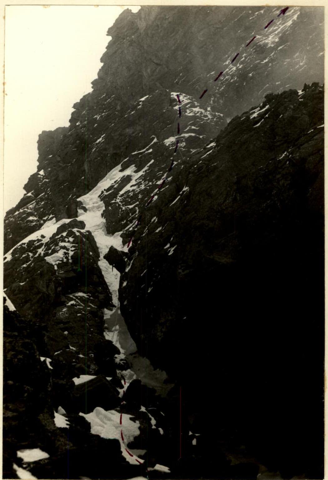
July 21. In the morning, directly from the ledge, we climbed up the wall via a somewhat indistinct internal corner - 40 m of strenuous climbing. Handholds were covered in snow. We used ladders, which were fixed in three places on this section (R10–R11).
We reached a small triangular platform covered in flow ice. No more than 3 people could gather there.
From the platform, we climbed directly up a 35-meter wall. Climbing was difficult. We organized a rope pull for the backpacks (R11–R12).
The upper part of section R5–R6. After the wall, a platform followed, above which an overhanging wall of 3.5–4 meters loomed. Again, ladders were used. The first climber went without a backpack, and the remaining participants were pulled up at the exit from the negative pitch (R12–R13).
Further:
- A snow-ice pitch and ascent to two rock walls with climbing of medium difficulty (R13–R14).
- The weather deteriorated. Very strong wind, occasional graupel, cutting into faces.
- Up a very narrow, sharp ice-snow ridge.
- Individual sections of the ice ridge (for the first time in the experience of all climbers) were traversed while sitting astride.
- Protection was through rock and ice pitons (R14–R15).
After the sharp ridge:
- Ascent to the right, bypassing a wall, through a gap between two large gendarmes.
- Rocks of medium difficulty, partly easy.
- Protection through pitons and outcrops.
- Between the gendarmes, in a snow-ice mulde, we set up a bivouac (R15–R16).
The weather had deteriorated completely. The wind was very strong, and it became even colder.
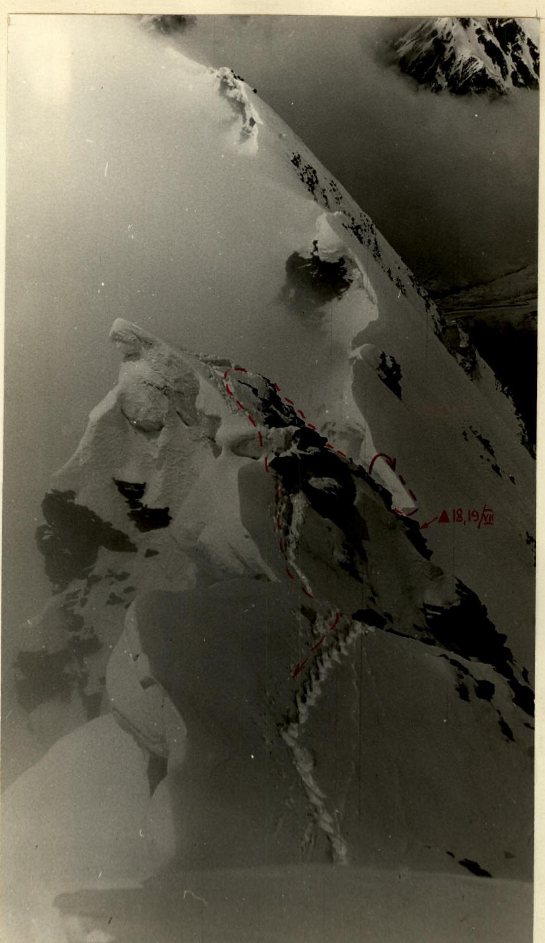
July 22. In the morning, the weather had not improved significantly. However, the route to the summit along the true ridge had been previously scouted and studied, so the group proceeded to storm the summit. Visibility was about 100 m. The snow was deep and loose. Although there were few steep sections, movement was very slow due to the altitude - over 6000 m.
- Around 12:00, the group reached the summit (R16–R17).
- Around 15:00, they descended to the bivouac site.
The weather remained bad. The climbers began to show signs of frostbite. We spent the night at the same location.
July 23. The group began their descent along the southern ridge at 9:00. A group of Leningraders from our gathering had previously climbed and descended this ridge (rated 5A category of difficulty). The previous day, they had provided a detailed consultation via radio communication. At 18:00, the group descended from the ridge, and around 20:00, the summit team reached the base camp of the expedition.
| Section № | Average Steepness | Length | Terrain Characteristics | Technical Difficulty | Time Taken | Pitons Driven | Pitons Driven | Pitons Driven |
|---|---|---|---|---|---|---|---|---|
| Total | Rock | Ice | ||||||
| Day I — Approach | ||||||||
| Day II | ||||||||
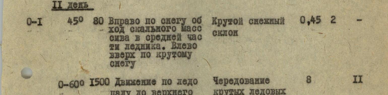
| R0–R1 | 45° | 80 m | Right up snow, bypassing rock massif in the middle part of the glacier. Left up steep snow. | Steep snow slope | 0.45 h | 2 | — | |
| R0–R6 | 150 m | Movement through icefall to upper plateau | Alternating steep ice pitches with gentle slopes | 8 h | 2 | |||
| Day III | ||||||||
| R1–R2 | 45–50° | 120 m | Bad weather. Processing part of the ascent route to the ridge. | Steep snow slope on ice substrate. | 3 h | 3 | 1 | |
| Day IV | ||||||||
| R1–R2 | 35° (lower), 60° (upper) | 110 m | Ascent to ridge via snow, loose and deep. Movement directly up. Avalanche risk. Upper part - hard, dry ice. | 4 h | 2 | |||
| R2–R3 | 10° | 50 m | Along rock massif, via snow in upper part when exiting to ridge-ice. | Quite difficult, upper 7–8 m difficult. | 1 h | 3 | — | |
| Bivouac Organization | 3 h | 6 | 2 | |||||
| Day V — Bad Weather |
Lower part of the 80-meter wall (R7–R8)