
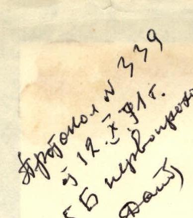
Protocol № 339 dated 12.09.1971 5B first ascent
VT-6 111
Report of the team from the Novosibirsk Regional Committee for Physical Culture and Sports on the ascent of Peak "40th Anniversary of LKSМУ" by Engel's Yu. South-West Pamir, 1971
leader: Bogomolov
Novosibirsk 1971

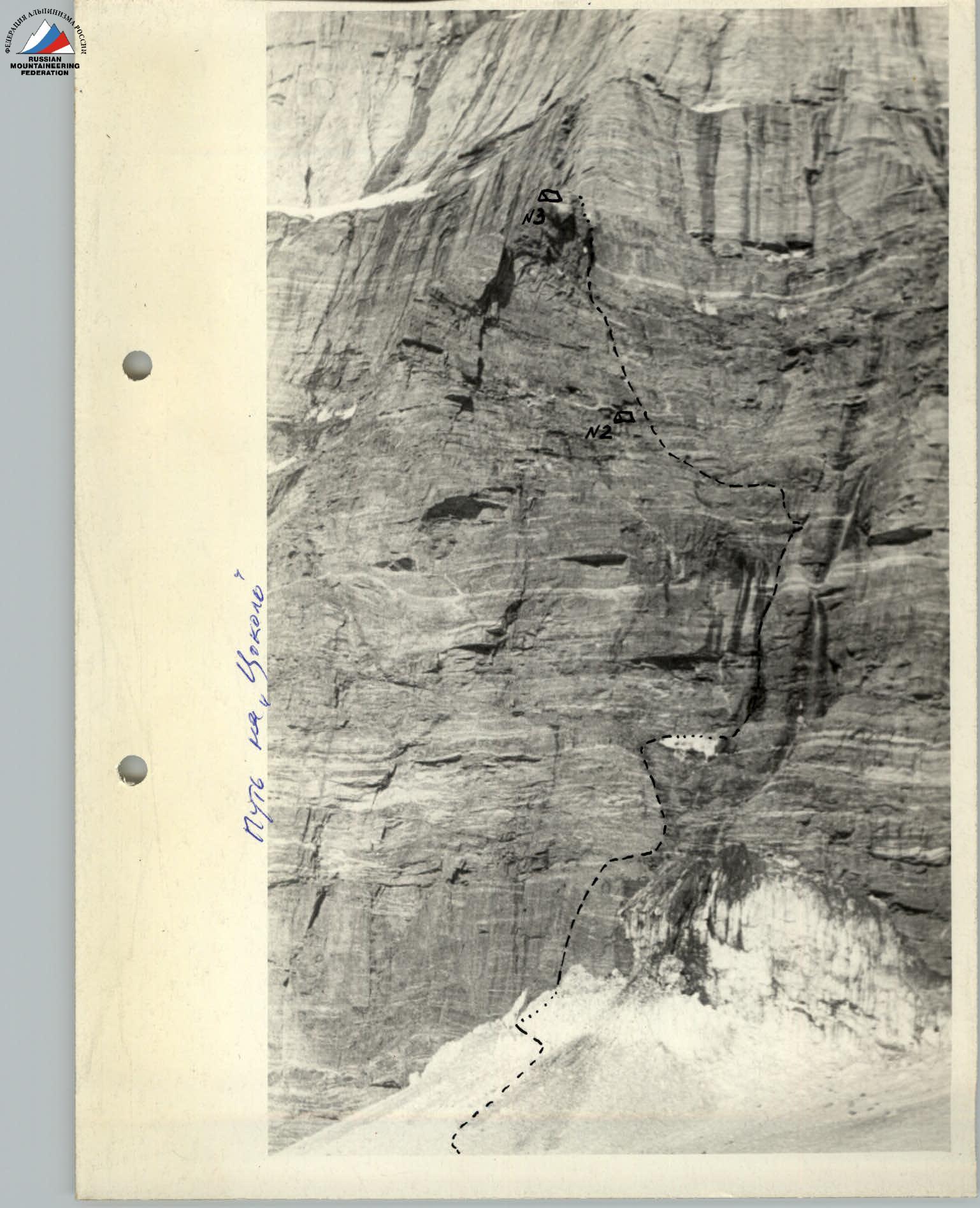
Fig. 1. Route of the team's ascent to Peak 40th Anniversary of LKSMU
Geographical location of Peak "40 лет ЛКСМУ" (6318 m). Approach to the southern wall of the peak
Peak "40 лет ЛКСМУ" is located in the South-West Pamir region, in the southern spur of the Shakhdara ridge, in close proximity to the key peaks of the region: Peak Marx (6726 m), Peak Tajikistan (6595 m), and Peak Engels (6510 m).
The approach to the peak begins from the village of Issor, located on the Ishkashim-Lyangar highway, 4 km from the village of Lyangar. The trail from Issor ascends along the southern slope to an irrigation canal and follows it eastward and then northward to the Kysh-Ty-Dzherob River, which feeds the canal. From here, the trail follows the right (orographic) bank of the river upstream along the Kysh-Ty-Dzherob valley in a westerly direction.
Here, opposite the cattle pens and slightly higher, on grassy meadows at an altitude of 4100 m above sea level, mountaineering expeditions typically set up their base camps. The journey from the village of Issor to the base camp takes 4-6 hours.
In the upper reaches of the Kysh-Ty-Dzherob valley, the massif of Peaks "40 лет ЛКСМУ" and Engels rises, separated by a glacial saddle.
From the base camp, the trail leads to the glacier tongue in 1.5-2 hours. Here, one must cross the river or follow the glacier tongue to the left (orographic) lateral moraine.
The trail continues:
- along the glacier along the valley slope;
- across scree slopes;
- along the lateral moraine into the upper cirque.
The trail ends at the upper end of the moraine under the southern buttress of Peak Danilaitis. Here, one must enter the glacier and move towards the "5200" pass, bypassing the icefall to the left.
After bypassing the icefall to the left, the path leads along Peak "40 лет ЛКСМУ" to a glacial plateau 200-300 m from the foot of the peak, above the icefall.
Caution is necessary - the plateau is heavily crevassed!
Here, at an altitude of 5000 m, 200-300 m (not closer - due to rockfall danger!) from the foot of the peak, one can set up:
- a storm camp;
- an observation camp.
The journey from the base camp to the storm camp takes 8-9 hours.
Climbing conditions in the Kysh-Ty-Dzherob valley area
The Kysh-Ty-Dzherob valley area, like the entire South-West Pamir region, is characterized by stable good weather in July-August. During the Novosibirsk expeditions' stay in the region in July-August 1970 and 1971, there were only a few days of overcast weather.
The altitude difference in the region reaches 1000-1500 m. The Kysh-Ty-Dzherob glacier tongue is located at an altitude of 4000-5100 m, and the surrounding peaks reach heights of 6000-6500 m. Calga-spores are common on glaciers and snowy sections of routes.
Rocks are often weathered and crumbling, with many wide cracks, predominantly horizontal. However, some walls are monolithic and smooth, with few cracks and holds (e.g., Peak "Moskovskaya Pravda", the south-eastern wall of Peak "40 лет ЛКСМУ", and Peak Engels).
The main rocks forming the peaks in the region are:
- granites and gneisses;
- cut through at various heights by layers of marble, quartz with outcrops of mica and asbestos.
Most peaks in the region are characterized by increased rockfall danger.
In the 1971 season, the following were active in the region:
- the "Vysochnik" mountaineering camp;
- about a dozen mountaineering expeditions.
The Kysh-Ty-Dzherob valley area is well-studied, described in literature, and has documented climbing routes.
Overview of the South-Eastern wall of Peak "40 лет ЛКСМУ" and climbing conditions. Justification for the route choice
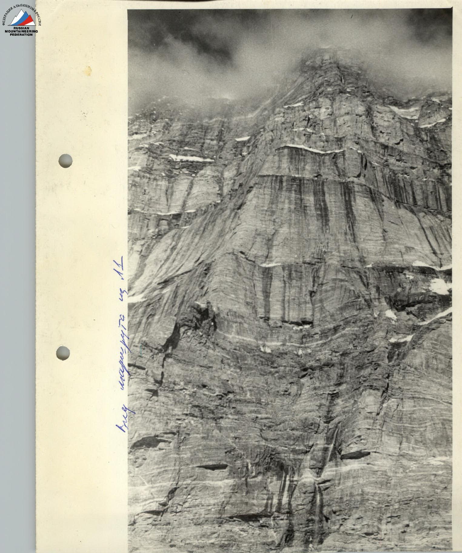
The eastern wall of Peak "40 лет ЛКСМУ" was first observed by Novosibirsk climbers in the summer of 1970. The wall consists of a series of vertical or near-vertical belts, separated by inclined scree-covered shelves, often covered with snow or ice.
The height of the wall from the foot to the summit is over 1300 m. The geological composition of the wall is gneisses and granites, cut through at various heights by layers of marble.
The wall is sunlit until 15-16 hours, and due to intense melting of snowfields and ice, water streams cover many sections of the wall. The abundance of cornices turns these streams into waterfalls. Even in light winds, water vapor fills the air, shrouding the wall.
As the sun sets behind the ridge, the rocks are covered with a thin layer of ice. Icicles hang in garlands along the entire wall.
Thus, despite being sunlit for a significant part of the day, the wall promised to be wet and cold. The logical paths to the summit along the south-eastern wall are two ridges with sides at an angle of 120-150°, leading to the southern shoulder of the peak. Each ridge has a "outer corner" shape at its base (the southern one protruding 100-150 m forward, and the northern one 30-50 m).
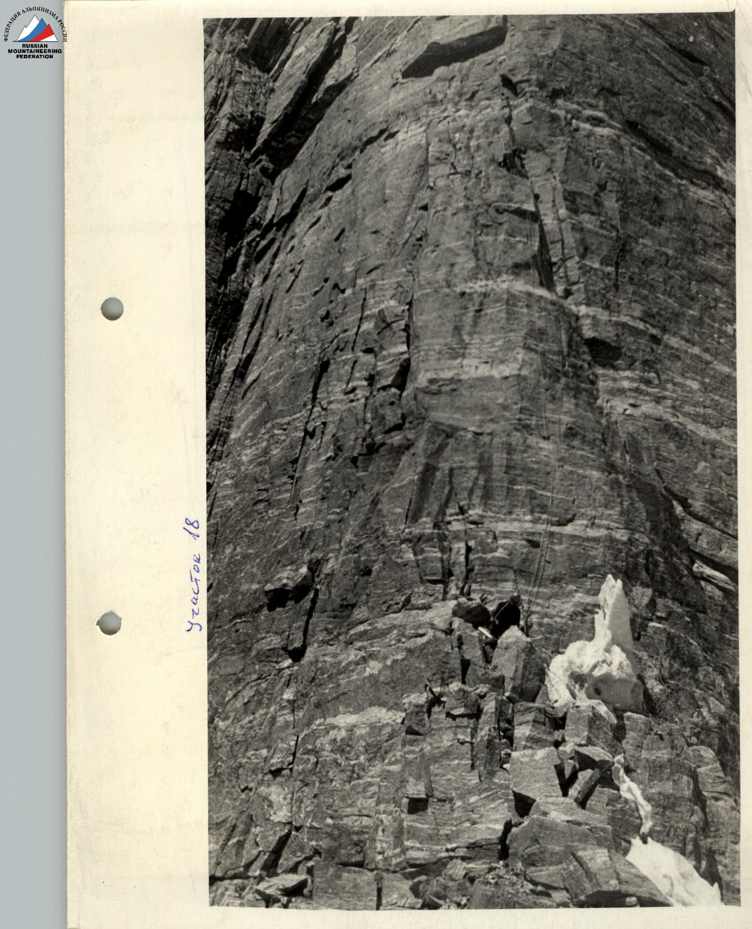
The belts forming the ridges and separated by shelves vary in height from several dozen to several hundred meters. The second belt (following the lower and first belts) is the most powerful, with a height of about 300 m on the left (southern) ridge and 150 m on the right (northern) ridge.
The left ridge is bounded on both sides by concave walls, conditionally referred to as couloirs, which are natural paths for rockfall. The right ridge has a couloir on the left, separating the left and right faces, and a snow-ice couloir on the right, descending from the saddle between Peak Engels and Peak "40 лет ЛКСМУ".
As a result of observing the wall in July-August 1970, it was concluded that both faces were passable and equally complex. Therefore, both routes were submitted for the USSR Climbing Championship.
However, the snow conditions in 1970 and 1971 differed significantly. In 1971, the shelves and pre-summit areas were almost free of snow cover, unlike the previous year. The rockfall danger on the wall increased sharply. With sunrise, rockfall occurred constantly along the couloirs. Continuous observation was established over the wall, leading to the following conclusions:
- The lower three belts of the left face are exposed to rockfall, and rockfall continues even when the sun is behind the ridge and the wall is in shadow.
- To process the second belt of the left face and pull up backpacks, 900-1000 m of rope is required. Bypassing the belt via couloirs is impossible due to their extreme complexity and rockfall danger throughout the day.
- On the right ridge, except for the lower belt, no significant rockfall was observed during the entire observation period. The lower belt (plinth) is rockfall-prone until 16:00.
- Rockfall danger on the lower belt of the right face decreases sharply after 16:00. During the entire observation period, only once, on July 24, 1971, at 23:00, a significant rockfall occurred after 16:00.
- The abundance of cornices on the right face promised to facilitate the choice of safe bivouacs.
- The route along the right face leads to the ridge 50-150 m from the summit, while the route along the left face leads to 300-350 m.
All these conclusions made the choice of route unambiguous - along the right ridge.
Planned composition of the assault group (as per applications), adjustments made to the composition before the ascent, and their justifications
The composition as per the application is as follows:
- BOGOMOLOV A.S. - captain
- KASPIROVICH G.E. - deputy captain
- BOGOMOLOV A.M.
- KALUZHKSKY L.A.
- MARTYNOV V.A.
- SARATOVKIN V.D.
- SERYOZNOV A.N.
- TEReshCHENKO V.A.
The team was primarily composed of climbers from the Novosibirsk "Trud" and "Zenit" societies. Except for V.A. Martynov ("Spartak"), they were all included in the main team for the USSR Climbing Championship. In May, the team composition was strengthened by athletes from the "Lokomotiv" society, as suggested by the Novosibirsk Regional Federation.
Initially, there were 14 potential team members. However, some were unable to attend the training camp due to work commitments: V.A. Martynov, L.A. Kaluzhsky, and A.M. Bogomolov. Considering the results of rock climbing training, acclimatization climbs, and medical check-ups, the coaching staff recommended the following team for the ascent:
- BOGOMOLOV A.S. - team captain
- KASPIROVICH E.G. - deputy captain
- BARKHATOV N.G.
- VODOLAZHSKY V.K.
- SARATOVKIN V.D.
- CHICHINADZE M.G.
Tactics and organization of the ascent
Reconnaissance climbs. Preliminary reconnaissance was conducted in the 1970 season: possible ascent routes along the South-Eastern wall of the peak were identified, an ascent to Peak Engels via Peak "40 лет ЛКСМУ" was made, and the wall profile was examined from the Romanov route on Peak Engels.
In the 1971 season, from the first days of the expedition, continuous observation of the wall was organized, resulting in the final selection of the ascent route and the development of tactics.
Provisions and equipment were transported to the Kysh-Ty-Dzherob glacier (4600 m) during an acclimatization climb.
Rockfall regime on the South-Eastern wall of Peak "40 лет ЛКСМУ". Recommendations for climbers
Rockfall is a significant and real danger for climbers on the South-Eastern wall of Peak "40 лет ЛКСМУ". This section attempts to generalize the results of observations on the wall during the summer periods of 1970-1971.
Naturally, these conclusions may not be indisputable or exhaustive due to the limited observation period. Over the month of observation in 1971, the intensity of rockfall increased towards the end of the period. It is possible that in some years, the lower belt of the wall will be impassable. Therefore, observation of the wall before each ascent to determine its condition is essential.
The couloir left of the ascended ridge is unsuitable for passage from the foot to the ridge. Individual rocks fall almost continuously during the day and night. Most rocks fall from the upper part of the wall and are often invisible. Daily rockfalls of 3-5 tons were observed.
The lower belt (plinth) is the most tactically complex part of the route due to its exceptional rockfall danger. Ascending the southern side of the "plinth" in the lower and middle sections is dangerous due to the tile-like structure of the layer and the abundance of water. Ascending the "plinth" directly is extremely challenging: the average slope is 80-85°, with many negative sections and cornices, and the rock structure is sometimes loose (asbestos). Processing and passing the "plinth" directly would require several days. Thus, despite the low intensity of rockfall, the probability of being hit by rocks is higher than when moving along the right (northern) plane of the "plinth". Processing and passing the lower belt were done after 16:00, when the sun was behind the ridge and the wall was in shadow. Working on the lower belt before 16:00 was completely unacceptable in the second half of July and the first half of August 1971 due to continuous rockfall.
The approach to the wall is moderately rockfall-prone. Under the wall, one must cross the randkluft and stop no further than 1-2 m from the rocks, as the glacier is exposed to rockfall 4-5 m from the rocks.
The first 50 m (sections R1-R5) of the route, despite their steepness, are not protected from rockfall. On these sections, the periline rope was hit, and many fresh rock impact traces were observed daily.
It is not permissible to:
- Move directly up the waterfall course;
- Cross the stream bed.
Rocks fall in these areas at any time of day.
Section R6, leading under the wall with cornices, should be passed without stops - it is very rockfall-prone. On this section, due to the gentle slope and abundance of loose rocks on the slabs, it was not possible to organize backpack pulling, so fixed ropes were installed to speed up progress.
The traverse to the right (section R6) is safe. Under the wall, on the left side, one can organize a supply depot and, if necessary, a bivouac.
The right part of section R7:
- is waterlogged;
- is more rockfall-prone.
Further ascent along the wall (sections R7-R14) after sunset was considered safe from a rockfall perspective. The group processing these sections should not exceed 2-3 people. Rest and belay points should be chosen exclusively under cornices or overhangs.
In the couloir above the wall (bivouac on section R14), safe overnight stays for 2-3 people can be organized under overhanging walls and cornices, although choices are limited, and bivouacs are wet and literally in water.
From the bivouac sites, one can:
- cross the couloir;
- reach the "plinth" summit before sunrise (4-5 hours of work).
The last 40 m:
- should be fully processed;
- after sunrise, the main mass of rocks falls to the right, near the couloir.
When processing and passing the lower belt, headlamps were used, as work continued until 23:00-24:00.
Camp №2 on the "plinth" summit and belt 1 (sections R18-R22) can be considered safe from rockfall. Despite continuous rock whistling over Camp №2 and sections R18-R22, no rocks fell on the group during their passage, and no rock impact traces were found.
Belt 1 is tempting to pass through a crack on the northern wall of the face (right of sections R18-R22). However, observations showed that this crack is exposed to rockfall with an average interval of 1-1.5 hours. Overcoming belt 1 via the crack requires significantly more time than this interval, making this variant unacceptable.
Overnight stays between the first and second belts and within the second belt are not rockfall-prone.
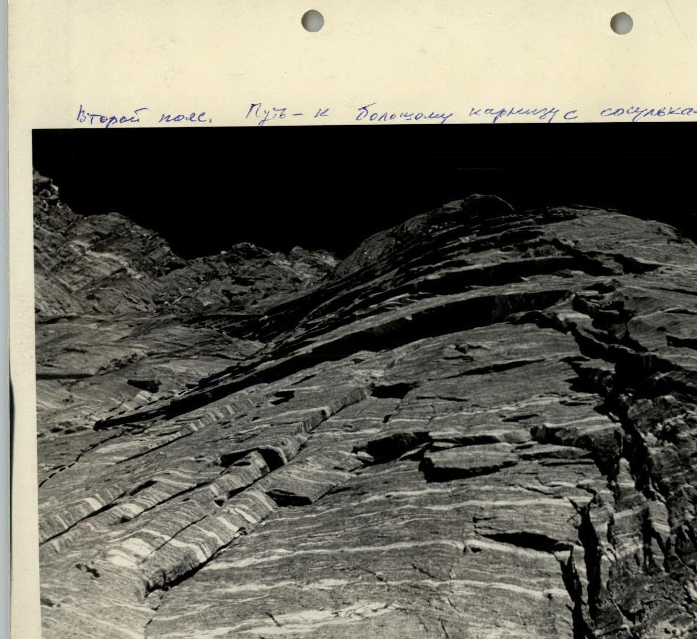
The shelf above belt 3 is rockfall-prone. Overnight stays can be safe only in a wet wall niche. Belt 4 (sections R29-R43) is moderately rockfall-prone.
After sunrise, icicles hanging in garlands along the wall pose a serious danger.
Overnight stays on sections R42 and R43 are exposed to rockfall and icicles after sunrise.
Sections R43-R48 of the route are moderately rockfall-prone after sunrise.
The ice-rock gully at the start of section R49 requires extreme attention and caution. Massive rockfall and ice slides occur with an interval of 5-8 minutes, and most rocks are visible during their fall.
The group adopted the following tactics for passing the gully:
- Passage after sunset.
- A watcher was stationed in a safe location to monitor the upper part of the gully.
- The first and subsequent participants passed the gully with backpacks to use them for protection in case of rockfall.
- Fixed ropes were installed.
Further sections of the route are not rockfall-prone but require increased attention due to the abundance of loose rocks.
The team can recommend the following to climbers:
- The optimal group size for the ascent is 6 people.
- A larger group increases the probability of being hit by rocks.
- A smaller group will not be able to maintain a sufficient pace along the route.
Additions to the profile scheme and table of basic route characteristics
After passing the first 90 m of the route (sections R1-R6), the team attempted to exit along the southern side of the pronounced ridge of the plinth. Reconnaissance showed that this variant was impractical due to reasons outlined in the "Rockfall Regime" section.
On sections R1-R5, the entire load was pulled up using ropes. After the overhang (section R9), a challenging 10 m traverse to the left is required to reach an internal corner. Backpack pulling was done from section R7 to the end of the internal corner (section R10) without intermediate belay points. This section is wet, and the participant assisting with backpack pulling through the cornice on section R9 had to stand in the lower part of the internal corner under water streams.
On July 30, 1971, the entire group reached the end of section R12. Then, a group of four descended along fixed ropes to the glacier (Storm Camp №1), and a pair, Vodolazhsky-Chichinadze, processed sections R13 and R14, installing fixed ropes and bivouacking under the protection of overhanging walls and small cornices.
On July 31, 1971, the pair successfully exited the rockfall-prone sections before sunrise and reached the "plinth" summit at 08:30. From 16:00 to 23:00, the entire team:
- removed fixed ropes up to section R13;
- transferred all cargo to the shelves of sections R14 and R15;
- lifted the necessary cargo for the overnight stay to the "plinth" summit and organized a bivouac.
The day was very tense.
On August 1, 1971, a pair processed belt 1 and installed fixed ropes. The rest of the team lifted all remaining cargo to the "plinth" and removed fixed ropes from sections R14-R17.
Route features:
- The first belt is very challenging to pass in ordinary boots - rock shoes are necessary.
- At the junction of belts 1 and 2, there is a control cairn.
- Section R25 includes a 20 m traverse under a cornice.
- Sections R25-R27 are wet, with water dripping from the cornice, making early starts for processing impractical due to the ice crust covering the route overnight.
Features of overcoming the remaining part of the route are described in the "Rockfall Regime" section.
Table
Basic characteristics of the route: South-Eastern wall of Peak "40 лет ЛКСМУ"
Height difference: 1309 m. Including complex sections: 938 m, of which the most complex are 671 m. Slope: 69°.
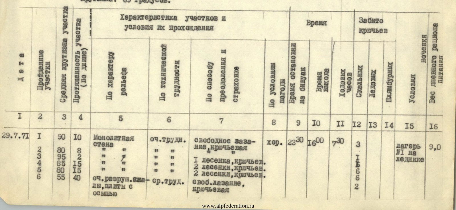
| Date | Sections | Slope° | Length, m | Terrain characteristics | Technical difficulty | Method of overcoming and belay | Weather | Bivouac stop | Exit | Hooks driven | Team size | Bivouac | Food, kg |
|---|---|---|---|---|---|---|---|---|---|---|---|---|---|
| 29.07.1971 | R1 | 90 | 10 | Monolithic wall | Very difficult | Free climbing, hook | Good | 23:30 | 16:00 | 3 | 9.0 | ||
| R2 | 80 | 8 | " | " | " | " | 1 | ||||||
| R3 | 95 | 2 | " | " | " | " | 1 | ||||||
| R4 | 85 | 15 | " | " | " | " | 2 | ||||||
| R5 | 80 | 15 | " | " | " | " | 2 | ||||||
| R6 | 55 | 40 | Very destroyed rocks, slabs with scree | Medium difficulty | Free climbing, hook | " | 2 | ||||||
| 30.07.1971 | Traverse 40 m, slabs, scree | Easy | Free climbing, hook | ||||||||||
| R7 | 70 | 15 | Wet rocks | Very difficult | Free climbing, hook | Good | 23:30 | 16:00 | 3 | 4 | Four in Camp №1, two in Camp №2, wet, separate 2 places | 9.0 | |
| R8 | 85 | 12 | Monolithic wet wall | 4 ladders, hook | " | 6 | |||||||
| R9 | 95 | 2.5 | Overhang | " | On a partner's shoulders, hook | " | 2 | ||||||
| R10 | 70 | 60 | Internal corner, wet | " | Free climbing, hook | " | 11 | ||||||
| R11 | 80 | 15 | Monolithic wall | " | 3 ladders, hook | " | 4 | ||||||
| R12 | 100 | 3 | Overhanging wall | " | Free climbing, hook | " | 5 | ||||||
| R13 | 60 | 60 | Destroyed rocks | Medium difficulty | " | " | 8 | ||||||
| R14 | 55 | 40 | Tile-like rock structure | Difficult | " | " | 7 | ||||||
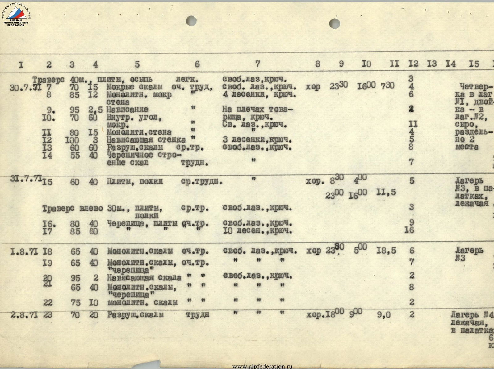
| 31.07.1971 | R15 | 60 | 40 | Slabs, shelves | Medium difficulty | " | Good. | 08:30 | 04:00 | 5 | Camp №3, in tents, lying down | 7.0 | |
| Traverse left 30 m, slabs, shelves | Medium difficulty | Free climbing, hook | 23:00 | 16:00 | 3 | ||||||||
| R16 | 80 | 40 | Tile-like structure, slabs | Very difficult | Free climbing, hook | 9 | |||||||
| R17 | 85 | 60 | " | " | 10 ladders, hook | 16 | |||||||
| 01.08.1971 | R18 | 65 | 40 | Monolithic rocks | Very difficult | Free climbing, hook | Good | 23:00 | 05:00 | 6 | Camp №3 | 7.0 | |
| R19 | 65 | 40 | Monolithic rocks, "tile-like structure" | " | " | " | 7 | ||||||
| R20 | 95 | 2 | Overhanging rock | " | Free climbing, hook | " | 2 | ||||||
| R21 | 65 | 40 | Monolithic rocks, "tile-like structure" | " | " | " | 8 | ||||||
| R22 | 75 | 10 | Monolithic rocks | " | " | " | 2 | ||||||
| 02.08.1971 | R23 | 70 | 20 | Destroyed rocks | Difficult | " | Good. | 18:00 | 09:00 | 2 | Camp №4, lying down, in tents | 6.6 | |
| R24 | 80 | 50 | "Tile-like structure", monolithic rocks | Very difficult | Free climbing, hook | 11 | |||||||
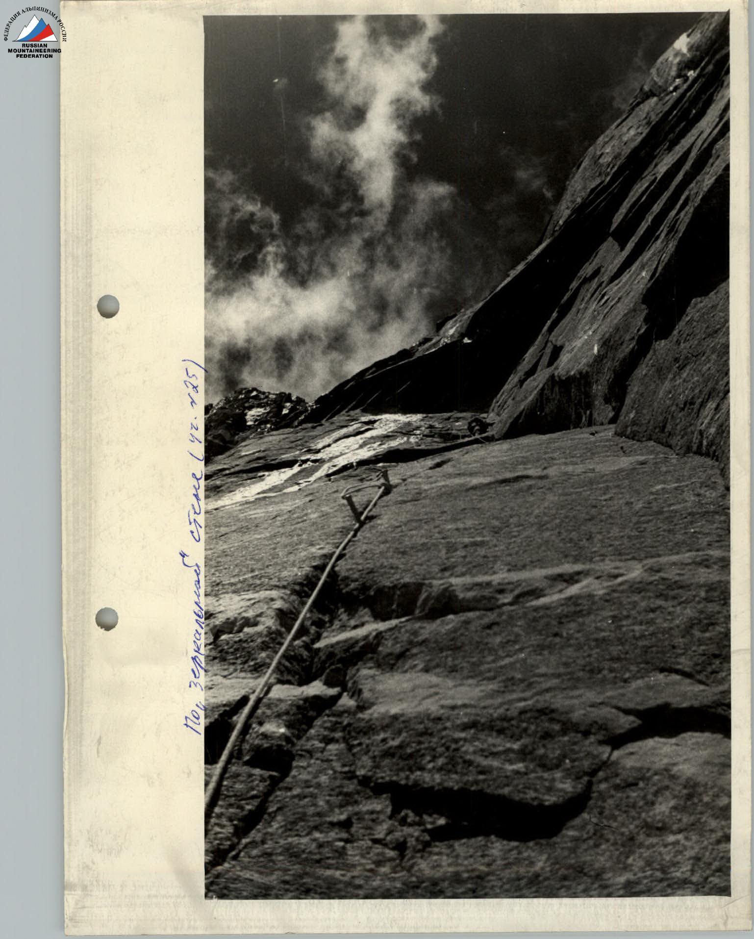
| 03.08.1971 | R25 | 85 | 60 | Smoothed rocks, "mirror" | 20 ladders, hook | Good | 19:00 | 09:00 | 31 | Camp №4 | 6.6 | ||
| 04.08.1971 | R26 | 100 | 8 | Overhanging monolith, waterfall, traverse | Very difficult | 12 ladders, hook | Good. | 23:00 | 10:00 | 18 | Two in Camp №5, wet, separate 2 places. 4 people - Camp №4 | 6.6 | |
| R27 | 90 | 12 | Wet smoothed rocks | 4 ladders, hook | 2 - 3 | ||||||||
| 05.08.1971 | R28 | 80 | 40 | Rocks with ice accretion | Difficult | Free climbing, hook | Good. | 21:00 | 10:00 | 6 | Camp №6, in tents, lying down | 7.0 | |
| 06.08.1971 | R29 | 70 | 10 | Dissected rocks | Medium difficulty | Free climbing, hook | Good. | 21:00 | 08:00 | 2 | Camp №7, in tents, lying down | 6.0 | |
| R30 | 90 | 4 | Smooth wall | Very difficult | " | " | 1 | ||||||
| R31 | 80 | 45 | Monolithic rocks | " | " | " | 6 | ||||||
| R32 | 60 | 10 | Ice-rock chimney | Difficult | " | " | 2 | ||||||
| R33 | 45 | 20 | Slabs, scree | Easy | " | " | 2 | ||||||
| R34 | 75 | 25 | Wet, icy rocks | Very difficult | " | " | 4 | ||||||
| R35 | 100 | 3 | Overhanging dissected wall | " | " | " | 1 | ||||||
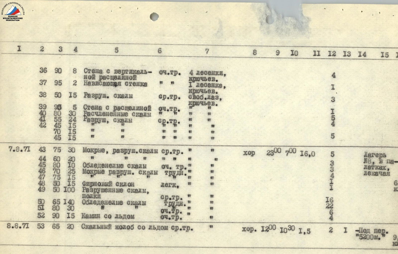
| R36 | 90 | 8 | Wall with vertical crack | Very difficult | 4 ladders, hook | 4 | |||||||
| R37 | 95 | 2 | Overhanging wall | " | 1 ladder, hook | 1 | |||||||
| R38 | 50 | 15 | Destroyed rocks | Medium difficulty | Free climbing, hook | 3 | |||||||
| R39 | 95 | 5 | Wall with crack | Very difficult | " | 1 | |||||||
| R40 | 80 | 30 | Dissected rocks | " | " | 5 | |||||||
| R41 | 55 | 24 | Destroyed rocks | Medium difficulty | " | 4 | |||||||
| R42 | 45 | 15 | Destroyed rocks | Medium difficulty | " | ||||||||
| R42 | 70 | 15 | Destroyed rocks | Medium difficulty | " | ||||||||
| R42 | 45 | 15 | Destroyed rocks | Medium difficulty | " | 5 | |||||||
| 07.08.1971 | R43 | 75 | 30 | Wet, destroyed rocks | Medium difficulty | " | Good | 23:00 | 07:00 | 5 | Camp №8, in tents, lying down | 6.6 | |
| R44 | 60 | 20 | " | " | " | " | 3 | ||||||
| R45 | 80 | 10 | Icy rocks | Very difficult | " | " | 3 | ||||||
| R46 | 70 | 25 | Wet, destroyed rocks | Difficult | " | " | 4 | ||||||
| R47 | 75 | 15 | " | " | " | " | 1 | ||||||
| R48 | 50 | 15 | Firn slope | Easy | " | " | 6 | ||||||
| R49 | 50 | 100 | Destroyed rocks, shelves | Medium difficulty | " | " | 16 | ||||||
| R50 | 65 | 140 | Icy rocks | Difficult | " | " | 22 | ||||||
| R51 | 80 | 30 | " | Very difficult | " | " | 6 | ||||||
| R52 | 90 | 15 | Chimney with ice | Very difficult | " | " | 4 | ||||||
| 08.08.1971 | R53 | 65 | 20 | Rocky gully with ice | Medium difficulty | " | Good. | 12:00 | 10:30 | 2 | 1 | Under the "5200" pass | 9.0 |
TEAM CAPTAIN A.S. BOGOMOLOV TEAM COACH P.A. KALUZHKSKY
 www.alpfederation.ru↗
 www.alpfederation.ru↗
Route scheme from 11

Path to the Plinth
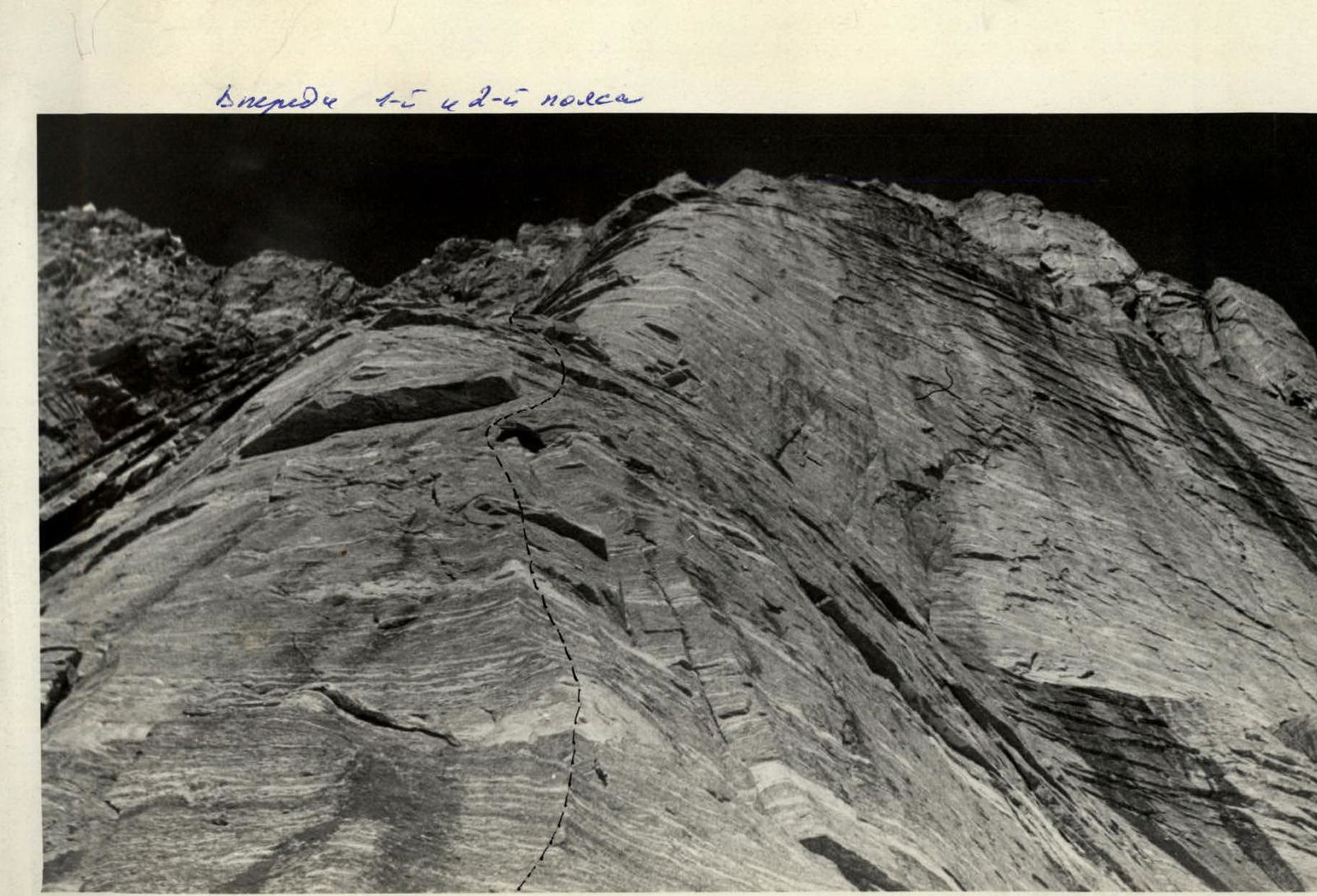
Ahead of belts 1 and 2

Along the mirrored wall (R42–R45)
![img-14.jpeg]({"width":1869,"height":1357,"format":"Jpeg","uri":"https://summitx.info/media/1/KlzJw38qucMUKCzswqFbjpFcyIls4zKp/img-14.jpeg↗