
USSR Alpine Federation Donetsk Regional Alpine Section

Report
of the Donetsk Alpinad participants on the traverse of the peak 40th Anniversary of Komsomol of Ukraine – peak Engels approximately 5–6 category of difficulty with the first ascent of the western wall of peak 40th Anniversary of Komsomol of Ukraine, carried out for the 1967 Ukrainian SSR alpine championship in the traverse class.
Donetsk, 1967
1. Geographical location and sporting characteristics
The area of peaks Marx and Engels is located within the Gorno-Badakhshan Autonomous Region of the Tajik SSR, in the southwestern Pamir, within the geographical coordinates: 37°02′–37°06′ north latitude and 72°29′–72°32′ east longitude. Alpinists began to explore this area relatively recently compared to other regions of the Pamir and Tian Shan. Only in 1954 did an expedition from the Georgian Alpine Club arrive here. They were the first to ascend several peaks in the area, including the highest point – peak Karl Marx (6726 m) from the south (from the East Nishgar glacier), and the third highest peak – peak Friedrich Engels (6510 m) from the south (from the Kishty-Dzherob glacier).
A high (over 6000 m) ridge from peak Leningrad State University to peak Marx drops steeply to the east into the Zughvand valley, forming a nearly vertical wall about 8 km long. The northeastern walls of peaks Marx and Engels (to the right of the Kustovsky route, beyond the wall's bend) can evoke admiration for their inaccessibility from any master of wall climbing. Therefore, with the recent introduction of a new class – high-altitude technically complex ascents – in the USSR alpine championship, this area has become very popular and will remain a pilgrimage site for many alpine groups for a long time.
In 1964, the Spartak Central Council Alpine Championship took place here, and in 1965, the Kabardino-Balkarian Alpine Championship was held. These alpine events established "golden" (the best of the season) routes of international (6th) category complexity:
- along the northeastern wall of peak Engels;
- traverse of peaks Engels and Marx with ascent to peak Engels via the northern ridge;
- along the eastern wall of peak Tajikistan (6565 m).
By 1967, several other interesting routes had been completed here: a non-classified, but undoubtedly worthy of 5B category, ascent to peak Engels via the southeastern ridge; an ascent to peak Engels from the Zughvand pass (5B category); an ascent to peak Tajikistan from the West Dridge glacier (5B category), achieved by S.M. Savvon's group. A snow-ice route of 5A category from the Zughvand pass to peak Marx is also noteworthy. Many more routes of various complexities await their climbers.
With modern transportation, reaching this area may seem relatively straightforward. However, due to the capricious weather in the western spurs of the Pamir and the existence of the so-called Rushan "window" (a narrow gorge under Rushan), flights from Dushanbe to Khorog are often delayed indefinitely. Therefore, it is often faster to travel from Dushanbe to Khorog by ordinary truck. After a 400-kilometer journey through numerous spurs to Khorog, the path from Khorog to the village of Lyangar-Kisht (just over 200 km) along the fairly flat and wide Panj River valley, along the border with Afghanistan, does not seem tiring.
In Lyangar, we were warmly received by border guards. At the outpost, they allocated a separate hut for our relay base. The outpost chief helped us contact the local population to hire a pack mule caravan, as we still had to ascend to the planned base camp, considering the cargo, for 5–6 hours.
The base camp of the Donetsk Alpinad in the southwestern Pamir was located in the upper part of the Kishty-Dzherob valley, which flows into the Panj valley near the village of Lyangar-Kisht. At the 4100 m mark, approximately 3 km from the end of the glacier tongue, a terminal moraine blocks the Kishty-Dzherob valley, creating a large, flat meadow from the alluvial soil. This meadow was also used by the Spartak Central Council expedition in 1964 and the Kabardino-Balkarian Alpine Championship in 1965.
The conditions for organizing the base camp here are excellent:
- complete safety;
- the pack caravan reaches the camp;
- flat areas for tents;
- clean drinking water.
In 1967, in addition to the Donetsk Alpinad, the following were also based here:
- Odessa Alpinad;
- Spartak MGS Alpine Championship.
The Kishty-Dzherob valley stretches submeridionally for 20 km, from northwest to southeast. The western slope of the valley is steep and rocky throughout, while the eastern slope is gentle and scree-covered. The valley is blocked by the massif of peak Engels and peak 40th Anniversary of Komsomol of Ukraine.
Geologically, the bottom of the Kishty-Dzherob valley and its slopes up to 4600–5400 m are composed of ancient Precambrian rocks, such as dark gray gneisses with various shades, strong and dense.
The upper parts of the ridges are composed of:
- magmatic rocks of granitoid composition (western slope of the valley);
- light gray, sometimes white, metamorphic rocks (eastern slope of the valley and the massif of peak Engels – peak 40th Anniversary of Komsomol of Ukraine).
The metamorphic rocks of the upper belt are softer and more susceptible to weathering.
Throughout the upper part of the Kishty-Dzherob valley, a clear contact line is visible between the lower series of Precambrian gneisses and the upper series of magmatic and metamorphic rocks. On the massif of peak Engels – peak 40th Anniversary of Komsomol of Ukraine and the Lietuva massif (eastern slope of the valley), well-defined layers of white marble up to 30–40 m thick are also visible in the upper part.
The Kishty-Dzherob glacier is relatively small (about 8 km long) and flat, with a slight icefall only when ascending to the Nispar pass in the northeastern part of the glacier. The glacier is closed, with the upper part of the snow cover being 15–20 cm thick. Calving is almost nonexistent, and seracs are rare. The Zughvand glacier appears similar in its upper part.
The eastern ridge of the Kishty-Dzherob valley has been almost completely explored. All significant peaks here have been conquered and classified: the Lietuva massif (peaks 5806, 6000, 6080, 6090, and 6141 m), peak Tbilisi State University (6141 m), and the Cherlenisa and Danilaitisa massif. In contrast, on the western ridge, only the peak "5491" near the Bezymanny pass (5200 m) has been conquered. The peaks between "5491" and peak Moskovskaya Pravda (6075 m) and further to peak Pamyati Zhertv Tetnuld (5746 m) not only remain unclimbed but also unnamed. The eastern slopes of the ridge between peak Moskovskaya Pravda and peak Pamyati Zhertv Tetnuld, which drop almost vertically onto the Kishty-Dzherob glacier, look very impressive and undoubtedly deserve the highest category of complexity for any route established here.
2. Reconnaissance exits
The base camp of the Donetsk Alpinad in the southwestern Pamir was set up on June 22, 1967. After its improvement, starting from June 24, participants of the Alpinad conducted a series of familiarization, acclimatization, and training exits.
Products and equipment were transported to the assault camp on the eastern (orographic left) lateral moraine of the Kishty-Dzherob glacier, at an altitude of about 4500 m, where there were convenient areas for overnight stays on a small green meadow. An exploratory-acclimatization exit was made to the upper reaches of the Kishty-Dzherob glacier, where a temporary camp was established. From here, we ascended to the passes:
- Bezymanny (5200 m);
- Nispar (5350 m).
to survey the area and gain preliminary familiarity with the nearby peaks. During the transportation of products and equipment to the assault camp on the Zughvand pass (5500 m), where a snow cave was dug for this purpose, we explored the upper reaches of the Zughvand valley and glacier.
All participants of the Alpinad, in various groups, conducted training ascents to unnamed peaks 5000–5200 m high, rising directly above the base camp, in both the eastern and western dividing ridges of the Kishty-Dzherob valley, via non-classified routes of approximately 2–3 category complexity.
During these exits, possible ascent routes to the most interesting peaks in the area were explored and studied, aided by three binoculars available to the expedition. The Donetsk Alpinad coaching council selected two very interesting and challenging routes for participation in the Ukrainian championship:
- in the class of high-altitude technically complex ascents – to peak Pamyati Zhertv Tetnuld via the unclimbed eastern ridge;
- in the traverse class – traverse of the peak 40th Anniversary of Komsomol of Ukraine – peak Engels massif.
3. Brief description of ascent conditions
The southwestern Pamir is characterized by very stable good weather. This was confirmed during our stay in the Kishty-Dzherob valley. Over 43 days (from June 22 to August 3), the base camp experienced cloudy weather only 2–3 times, typically for a very short period (2–3 hours). Even then, the cloud cover was light, and no precipitation occurred. "Up high," groups sometimes encountered a cloud band, which significantly reduced visibility and brought light snowfall. Strong winds were occasionally observed during ascents. Overall, weather conditions were quite satisfactory:
- the vast majority of ascents were conducted in clear weather;
- bad weather did not disrupt any of our ascents.
Similar reports were found in the records of all previous expeditions to this area, so we did not expect any particular surprises from the weather and were not mistaken.
Given that the western wall of peak 40th Anniversary of Komsomol of Ukraine ends in a snowy slope, we considered the possibility of water and potentially rimed ice on the rocks. The wall itself is like a layered pie, consisting of three rock belts alternating with steep snowy slopes. Since the wall is at a significant height (5500–6000 m) and faces west, receiving sunlight only in the afternoon, we were almost certain that we would encounter rock sections with rimed ice. However, due to the stepped structure of the wall and numerous rock overhangs and cornices, it was impossible to identify such sections when studying the route.
The doctor of the Donetsk Alpinad was very meticulous in his duties. Out of six candidates for the assault group:
- three were disqualified due to health issues or showing early signs of fatigue from previous ascents. However, once the doctor cleared someone for an ascent, it was certain that the participant not only felt excellent but also had the right mental and volitional state.
The selection of equipment in our expedition was such that it allowed for ascents of any complexity. In addition to thorough checks and tests of all our equipment in previous years, we had already put it to the test here, in the southwestern Pamir, during sufficiently serious ascents.
4. Organizational and tactical ascent plan
Peak 40th Anniversary of Komsomol of Ukraine (6200 m) and peak Engels (6510 m) are separated by a narrow saddle with minimal height difference and form a single massif, closing the Kishty-Dzherob valley and distinct from its western and eastern dividing ridges by the Bezymanny (5200 m) and Nispar (5350 m) passes.
In reports from the first explorers of this area, both peaks were often referred to under the common name peak Engels, with:
- the actual peak Engels described as the Main peak;
- peak 40th Anniversary of Komsomol of Ukraine referred to as the Western or Southern peak.
In the Classification Table of USSR Peaks, effective as of June 1, 1967, a 5–6 category route "Along the western ridge of peak Engels from the Zughvand pass" is classified.
In reality, it is the western ridge of peak 40th Anniversary of Komsomol of Ukraine that descends to the Zughvand pass, becoming broad and indistinctly expressed in its upper part, and smoothly merges with a small snow-ice plateau occupying the saddle between peaks Engels and 40th Anniversary of Komsomol of Ukraine.
Thus, climbers following the classified 5–6 category route:
- ascend the western ridge of peak 40th Anniversary of Komsomol of Ukraine;
- around the 6000 m mark, traverse left onto the saddle;
- then proceed to peak Engels.
The descent follows the ascent route.
We were immediately impressed by the massif of these two peaks upon arriving at the base camp and decided to traverse it for the Ukrainian championship. The most accessible route to the massif is the aforementioned classified 5B category route. However, ascending and descending via the same path, which is technically the most challenging part of the route, would contradict the essence of a traverse. Therefore, it was necessary to identify a new ascent route to the massif. This was chosen during the exit to transport products and equipment to the assault camp on the Zughvand pass and was studied and detailed during ascents to peaks Marx and Engels from the Zughvand pass.
The western slope of peak 40th Anniversary of Komsomol of Ukraine appears as follows: to the right of the aforementioned ridge, along which the 5B category route is laid, lies a broad, diffuse couloir, or rather, a branched system of individual couloirs. Further to the right begins the multi-tiered western wall, broken in many places by vertical gullies. At the top, the wall ends in a steep snowy slope, resembling a roof, leading to the very crest of the peak and the southern ridge descending to the Bezymanny pass. Snow (and sometimes rocks) falling from the right part of the crest and the southern ridge directly onto the wall means ascending this part of the wall would disregard basic safety rules.
However, about 500 m from the couloir, where a vertical ledge is clearly visible in the wall, a weakly expressed ridge extends from the upper edge of the wall, diagonally crossing the slope from right to left – steeply upwards – and towards the crest ridge. This ridge shields the upper part of the wall at the vertical ledge. We decided to ascend the wall, specifically the third rock belt – the most complex and powerful – via this protected section. The first two rock belts were better approached 50–60 m to the left of the nearly vertical line of the ledge.
To overcome certain sections, we planned to use piton hooks, especially since:
- the middle rock belt (clearly visible from below) consisted of marble, which is easily drilled;
- the other two belts are composed of metamorphic rocks, which are much easier to physically break than magmatic rocks;
- participants in the assault group had successfully used drilling to overcome complex rock sections on multiple occasions.
By the time we embarked on the traverse of the peak 40th Anniversary of Komsomol of Ukraine – peak Engels massif, several groups from all three expeditions (ours, Odessa, and Spartak MGS) had ascended peak Engels via the 5B category route. Therefore, we knew that with a good pace:
- it was entirely possible to ascend from the Zughvand pass to the saddle between peaks 40th Anniversary of Komsomol of Ukraine and Engels in one daylight period;
- it was also possible to descend from the saddle to the Zughvand glacier in one daylight period.
All other routes to the massif, clearly visible from below, were much more complex and lengthy for both ascent and descent. Considering this, we decided to descend via the 5B category route.
Ascending with backpacks from the base camp to the Zughvand pass takes 14–16 hours, as we had confirmed multiple times from our own experience. The return journey without significant effort can be completed in 7–8 hours.
Thus, the tactical plan for the traverse of the peak 40th Anniversary of Komsomol of Ukraine – peak Engels massif was as follows:
- July 23, 1967 – the assault group, along with all participants of the Donetsk Alpinad, ascends to the assault camp "4500" on the eastern moraine of the Kishty-Dzherob glacier.
- From here, our younger comrades, in separate groups under the overall leadership of USSR Master of Sports V.N. Bocharov, conduct a series of qualification ascents to peaks such as peak Tbilisi State University, peaks Cherlenisa and Danilaitisa.
- July 24 – the assault group proceeds through the Bezymanny pass under the western wall of peak 40th Anniversary of Komsomol of Ukraine.
- July 25–26 – the western wall is overcome, with exit onto the southern ridge of peak 40th Anniversary of Komsomol of Ukraine.
- July 27 – traverse of peaks 40th Anniversary of Komsomol of Ukraine and Engels, and descent to the saddle between them.
- July 28 – descent via the 5B category route to the Zughvand pass.
- July 29 – return to the base camp.
During the assault, we largely adhered to the planned tactical plan, except that we managed to complete the traverse of peaks 40th Anniversary of Komsomol of Ukraine and Engels and descend to the assault camp on the Zughvand pass in one daylight period.
The assault group's backup was ensured through interaction with groups from other expeditions, as decided at a joint meeting of the leadership of all three Alpinads. By the time we embarked on the route, two auxiliary groups were present on the Zughvand pass, from where both the western slopes of peaks 40th Anniversary of Komsomol of Ukraine and Engels, and the eastern slopes of peaks Marx, Nikolaadze, and "6183" were visible:
- a group of Muscovites observing the group led by V. Kavunenko, which had completed the traverse of peak 40th Anniversary of Komsomol of Ukraine – peak Engels – peak Marx – peak Nikolaadze – peak "6183" for the USSR championship. On July 25–26, they ascended peak Engels (5B category), and on July 27, they descended to the base camp.
- a group of Odessans interacting with the group led by Lifshits, which was conducting the traverse of peak Engels – peak Marx for the Ukrainian championship. On July 26–27, they ascended via the same route. On July 28, a quartet of Odessans led by Popov descended to the Zughvand pass and remained there, awaiting Lifshits' group.
Since the Muscovites departed from the Zughvand pass on July 27, on July 28, our observers, led by V. Bocharov, were to relocate from the assault camp "4500" to the Zughvand pass. They were to wait there for our assault group and then ascend peak Engels via the 5B category route.
Thus, we were under observation by two auxiliary groups throughout.
5. Assault group composition
Initially, the assault group was planned to consist of four people. However, before the scheduled ascent date, Alekseenko A.A. fell ill and was sent down. Replacing him was challenging, as the most suitable candidates – Zhelobotkin P.I. and Zalutaev L.P. – were deemed by the doctor to be tired from previous ascents and in need of extended rest before such a complex and responsible route. Including one of the auxiliaries in the assault group would have disrupted the sports development plans of the Alpinad. Therefore, we decided to proceed with a trio for the assault. Oleg Polyakovsky was confirmed as the ascent leader. The assault group consisted of:
- Oleg Ivanovich Polyakovsky – born 1936, Polish, CPSU member, Category I Sportsman, 13 years of alpine experience, mining geologist. City of Artemovsk, Donetsk region, Artema St., 40, apt. 47.
- Viktor Nikolaevich Rusanov – born 1938, Russian, non-party, Master of Sports, 12 years of alpine experience, mountain technician. City of Donetsk-58, Revolyutsionеров St., 91.
- Veniamin Grigoryevich Sivtsov – born 1933, Russian, non-party, Master of Sports, 17 years of alpine experience, radio technician. City of Donetsk-30, Fakultetskaya St., 3, apt. 8.
6. Route description and passage order
On July 23, the assault group, along with the entire Donetsk Alpinad, moved to the assault camp "4500". The base camp was empty by this time.
On July 24, at 8:00, we departed from the assault camp "4500" towards the Bezymanny pass and further to the beginning of the route (R1). The approach path is not technically complex. The only challenging section is a 30-meter steep (50°) snowy slope from the Bezymanny pass towards the Zughvand valley. However, since observers and participants of the Spartak MGS Alpinad passed through the pass daily, they had installed ropes in this section.
There was no need to ascend to the Zughvand pass. We set up a tent directly under the route at 17:00. We once again examined the route along the wall and trod paths to the most convenient spot to cross the bergschrund, which stretches from the Zughvand pass to the Bezymanny pass along the entire western slope of peak 40th Anniversary of Komsomol of Ukraine. We did not cross the bergschrund, as its upper edge overhangs the lower by 1.5–2 m, and it would be easier to do so the next day on frozen snow.
On July 25, 1967, at 6:00, we departed from the bivouac. The rope team was formed as follows: Polyakovsky – Sivtsov – Rusanov. Polyakovsky stood on Sivtsov's shoulders and climbed onto the upper edge of the bergschrund (R2).
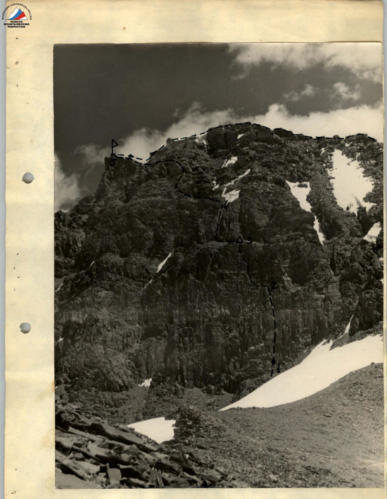
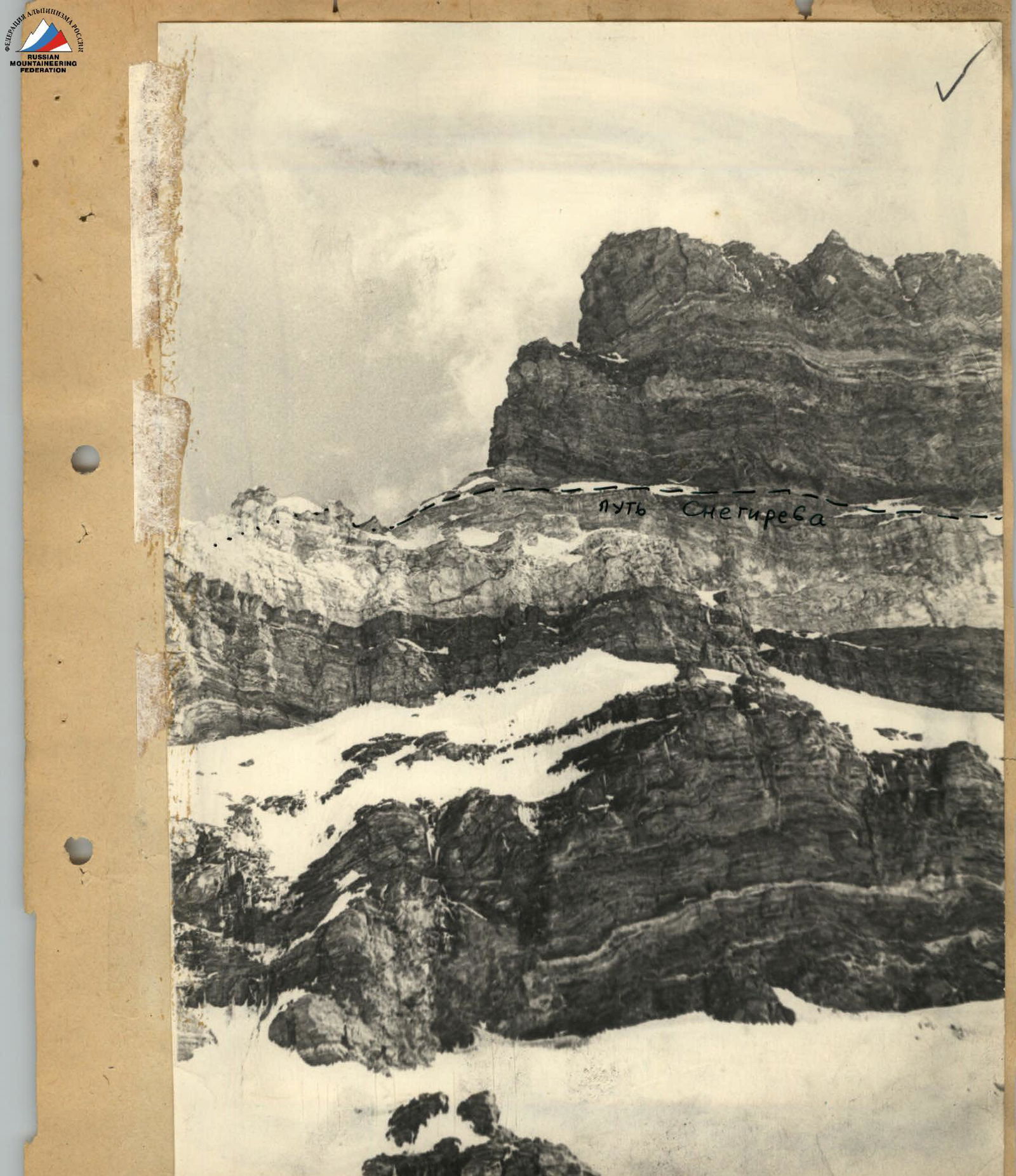
Schematic drawing of the ascent path to peak Engels via peak 40th Anniversary of Komsomol of Ukraine with ascent along the western wall. View from the slope of peak 6350 (from the west). — — — Path of ascent by the team — . — Simplest path / Snegirev's path / ∆ – Biwacs.
The others ascended using jumar ascenders on the fixed rope. We climbed slightly diagonally left towards the first rock belt via a not very steep (40°) snowy slope (R3). The snow held well, and we moved simultaneously.
First rock belt. Polyakovsky led, navigating 30 m through difficult, smooth rocks (R4) and then veered right onto weakly expressed ledges (R5). The ropes were just enough to secure ourselves at the upper edge of the rock belt. The next 30 m to the following rock belt involved a steep (50°) snowy slope (R6), but the snow still held well.
The second rock belt was as steep as the snowy slope and was made of white marble, partly covered in a thin layer of milky-white rimed ice, making it almost indistinguishable from the snow in color. To the left, a crack appeared, noticeable only because its edges were slightly rounded; it immediately closed deeper, and only due to our titanium hooks could we hammer them into this hint of a crack.
For almost every step, Rusanov hammered in a hook as we progressed along this crack, and eventually, it ended. To the right and upwards, a rounded, smoothed bulge appeared. Drilling into the ice, and sometimes the rock, allowed us to advance, but it was necessary to frequently hammer in piton hooks for insurance. The rope work was laborious.
Finally, we reached the upper edge of the second rock belt (R7). Rusanov stood on a large inclined platform, receiving the others.
We rested and had lunch, even warming tea using a "Febus" stove.
From here, we traversed 2 rope lengths as directly as possible to the right, across a steep (45°) snowy slope (R8), to the start of the ascent up the third rock belt. However, the snow was now loose, and we ascended slowly, sometimes sinking up to our knees. The rock relief of the third belt was very complex, with an average wall steepness of 75–80°. Polyakovsky ascended along a weakly expressed outer corner (R9). The rocks were very difficult, often requiring the use of ladders. When it seemed we would have to accept the next participant while standing on ladders, the outer corner ended in a small but convenient platform. Sivtsov was accepted, backpacks were pulled up, and Rusanov was accepted. It turned out that we could fully rest here, sitting on our backpacks. There was still time, and we attempted to make ourselves more comfortable on the rope above. If there wasn't a more comfortable bivouac spot above, it wouldn't be a problem – we could rest on the processed path the next day.
Further up, an internal corner with a slit inside led upwards. Fingers could be inserted into the slit, somewhat easing the ascent. However, after 5 m, the slit narrowed into a crack where hooks could be hammered. The rocks were very difficult (R10): there were holds only for the first phalanges of fingers, and frequent rest required hanging ladders. Yet, once we overcame the meters of the internal corner, our perseverance was rewarded – a large, convenient platform for a bivouac lay above. It was just in time; when we pulled up our backpacks and gathered on the platform, it was 21:00. We cleaned the platform of rocks and set up a tent in the twilight.
Thus, 2 rope lengths of the third rock belt were completed, and we were satisfied with the sections passed during the day.
On July 26, 1967, we dismantled the bivouac at 9:00, as working on the rocks was too cold before then. We left a control cairn at the bivouac site.
If we had ascended the wall near the ledge so far, we now had the opportunity to cross to the right over the edge of the ledge and ascend on the right side of this giant outer corner, as the platform with our tent was located right on the edge of the ledge. We began ascending the right wall of the ledge – now envisioned as a huge outer corner – from the platform upwards (R11), which consisted of separate blocks 6–7 m high. Ascending here was easier than over the first two rope lengths, although we had to drill and hang ladders in two places. However, pulling up backpacks was much more challenging than on the relatively smooth rocks of the previous day. Here, backpacks frequently got stuck in the gaps between blocks, and we spent about an hour with them.
The next rope length was passed through another internal corner (R12), a deep one, where we could climb using both walls of the corner like a chimney. It was harder to ascend here than on the blocks, but pulling up backpacks was easier. The final rope length of the third rock belt (R13) presented an almost vertical wall with numerous ledges. The first person ascended without a backpack; the rest followed with backpacks. By 14:00, it was time for lunch.
As observed from below, a weakly expressed ridge led from the upper edge of the third rock belt to the southern ridge of peak 40th Anniversary of Komsomol of Ukraine. It was mainly snowy, with frequent rock outcrops, about 250 m long (R14) and with a steepness of about 50°. From below, this section seemed fairly simple. However, the snow was shallow (5–7 cm), and beneath it lay rimed ice. The thawing snow held very poorly, and we had to ascend cautiously from one rock outcrop to another, where we hammered in rock hooks for insurance, sometimes cutting steps in the ice and clearing snow. This section took over 4 hours. Finally, we reached the southern ridge of peak 40th Anniversary of Komsomol of Ukraine. A large snow cornice, formed by constant easterly winds, lay on the western side of a small gendarme standing on the ridge. It was calm here, and the wind was not felt. We noticed that a group led by Kavunenko, who had traversed the southern ridge, had recently bivouacked here. We stopped for the night as well, as it was hard to find a more convenient spot. The time was 19:00. At 21:30, we signaled our auxiliaries with a flare that we had reached the main ridge and that everything was fine.
On July 27, 1967, at 8:00, we departed from the bivouac. Ahead lay 200 m of a gentle but complex rocky ridge with numerous gendarmes and snow drifts (R15). All gendarmes were bypassed on the left, along a steep snowy slope. Hooks for insurance were hammered into the rocks of the gendarmes.
The summit tower of peak 40th Anniversary of Komsomol of Ukraine is a fan-shaped ridge stretching from north to south. Ascending from the south, we faced a very steep 60-meter ascent up a sharp rocky ridge (R16). It dropped vertically to the west and was adorned with a large cornice on the east side, towards the Kishty-Dzherob glacier. It would have been easier to ascend on snow, but the cornice did not inspire confidence, so Sivtsov began the ascent up the 80-degree rocky ascent. The rocks were very difficult, but it was possible to ascend without piton hooks and ladders. Backpacks were pulled up using a pendulum motion towards the western slope and then easily lifted.
Further on, a very gentle, wide, scree-covered summit ridge stretched for 100 m (R17), and we reached the cairn of peak 40th Anniversary of Komsomol of Ukraine. We replaced Kavunenko's group's note with our own and descended along a gentle (25°), 200-meter snowy slope (R18) to the saddle under peak Engels, noticing the Odessans overcoming the final meters of the summit ascent of peak Engels.
The weather was excellent. We took one backpack with warm clothes, some food, and began the ascent to peak Engels, leaving the rest of our gear on the saddle.
The southern shoulder of peak Engels initially extends gently from the pre-summit rocky ascent and then sharply drops onto the saddle. From the saddle, we ascended diagonally across the snowy western slopes of the southern shoulder. The average steepness of the snowy slopes was 35–40°, and the ascent length was about 500 m. We moved simultaneously on the ready-made tracks of the Odessans (R19). The steepness of the rocks on the pre-summit ascent averaged 65–70°, with a difficulty above average, and a height of 3 rope lengths (R20). The rocks were tiered, with short (5–8 m) steep walls and numerous holds. We hammered in hooks for insurance and left them in the rocks with carabiners for faster descent. After the rocky ascent, a long (350 m) gentle snowy ridge followed (R21), with large cornices towards the Kishty-Dzherob glacier. Therefore, we stayed 8–10 m below the ridge.
On the summit of peak Engels, we met the Odessan group led by Popov, who were attempting to audibly detect the proximity of Lifshits' group ascending via the southeastern ridge. However, no sounds characteristic of an ascending group were heard, so they planned to stay on the summit for another 2 hours. Their tent was set up a bit below the saddle, and they intended to bivouac there. We exchanged notes in the cairn, had a quick snack, and began our descent.
We descended to the saddle via the ascent route, retrieved our backpacks, and decided to continue descending. Knowing that there were spots for overnight stays on the route, we decided to descend as long as time allowed. We descended via the classified 5B category route (R22). The ridge we descended was predominantly rocky, with the same three rock belts as on the western wall of peak 40th Anniversary of Komsomol of Ukraine, but the rocks here were gentler, and the snowy intervals between them were smaller.
During the descent, we hung ropes for "dülfer" only three times:
- twice on the upper rock belt;
- once on the lower belt.
The rest of the descent was completed by climbing with hook insurance. We reached the Zughvand pass at 21:00 and bivouacked in a snow cave in our assault camp.
On July 28, 1967, at 6:00, we departed from the bivouac, heading through the Bezymanny pass back to our base camp. The early departure was due to the long journey ahead on snow and the need to meet and return our auxiliaries, as we no longer needed their assistance. We met the auxiliary group on the Bezymanny pass and returned together to the base camp.
7. Overall assessment of actions
Assault participants
All participants in the assault group were well-prepared for the ascent. The group thoroughly studied the route and considered every detail when selecting equipment and supplies. Each participant performed the tasks assigned during the development of the ascent tactical plan, led on specific sections, and demonstrated sufficient alpine competence to handle any difficulties on the route.
The entire group acted cohesively and organized during the traverse, maintaining a very high pace of movement while strictly adhering to all safety rules for mountain ascents.
8. Additional data on route characteristics
Route
The height gain from the Zughvand glacier during the traverse of the peak 40th Anniversary of Komsomol of Ukraine – peak Engels massif was approximately 1100 m. The actual traverse of the main ridge, where both peaks are located, was conducted at altitudes of 6000–6500 m. Thus, the traverse is classified as high-altitude.
Undoubtedly, the most complex part of the route was overcoming the western wall of peak 40th Anniversary of Komsomol of Ukraine. However, even during the traverse itself, the assault group encountered complex rocky sections at significant heights.
The ascent via the western wall of peak 40th Anniversary of Komsomol of Ukraine is more challenging than the classified 5B category route from the Zughvand pass to peak Engels, as the most complex part of the latter is the ascent along the western ridge of peak 40th Anniversary of Komsomol of Ukraine. The ridge features rock sections of the same structure as the western wall but is naturally much gentler.
Therefore, the participants of the assault group and the leadership of the Donetsk Alpinad propose classifying the independent route to peak 40th Anniversary of Komsomol of Ukraine with ascent via the western wall and descent along the western ridge to the Zughvand pass as 5–6 category complexity.
Consequently, we consider the traversed route of the peak 40th Anniversary of Komsomol of Ukraine – peak Engels massif to be worthy of 5B category complexity. The proposed route via the western wall to peak 40th Anniversary of Komsomol of Ukraine should be recommended only to groups whose participants are familiar with piton hook techniques, as it is sometimes necessary to use piton hooks for insurance in certain sections.
Leader of the Donetsk Alpinad in the southwestern Pamir: V. Sivtsov Chairman of the coaching council: V. Bocharov Leader of the assault group: O. Polyakovsky
| Date | Section | Steepness (°) | Length (m) | Characteristics of sections and passage conditions | Tech. difficulty | Insurance method | Weather | Time | Pitons driven | Bivouac conditions | Daily ration weight (kg) | Notes |
|---|---|---|---|---|---|---|---|---|---|---|---|---|
| 23–24.07.1967 | R1 | 10 | 12,000 | Approaches along the glacier | 2A | Simultaneous | Clear | – | – | 15 | – | Good conditions |
| 25.07.1967 | R2 | 90 | 2 | Bergschrund | 5A | Alternate | – |