
-
Climbing category — high-altitude technical.
-
Region — Pamir, Ishkashimsky Range.
-
Shater, 5568, center of the NW wall.
-
Proposed route — 6B category of difficulty, first ascent.
-
Height difference — 1318 m, length — 1680 m, length of sections with 5-6 category of difficulty — 920 m. Average steepness of the main part of the wall — 82°, average steepness of the wall up to the ridge — 73°.
-
Pitons hammered: rock: 405/197 bolts: 160/6 chocks: 352/174 ice screws: 19
-
Team's climbing hours — 56 h 50 min and days — 5.
-
Overnight stays: one semi-reclined and three hanging (in a platform tent and hammocks).
-
Team leader: Vladimir Bалыberdin MSМК, Viktor Zhak MS, Yury Razumov MS, Alexander Glushkov MS, Mikhail Aivazov MS, Dmitry Ovsyannikov MS, Nikolay Shustrov CMS, Yury Pozhidaev CMS.
-
Team coach — Yury Dzhibraev.
-
Date of departure — July 20, 1985 date of reaching the summit — July 24, 1985, return — July 24, 1985.
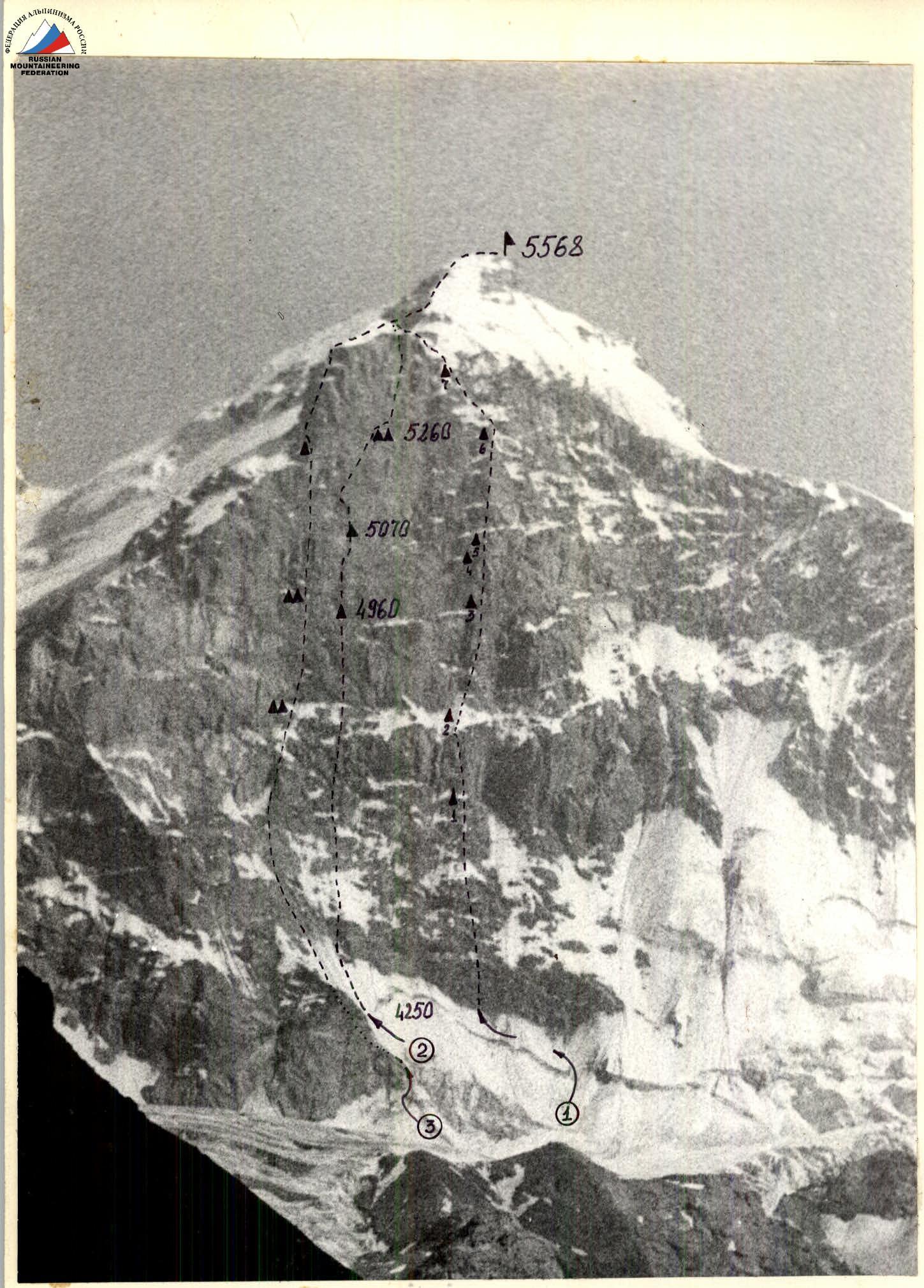
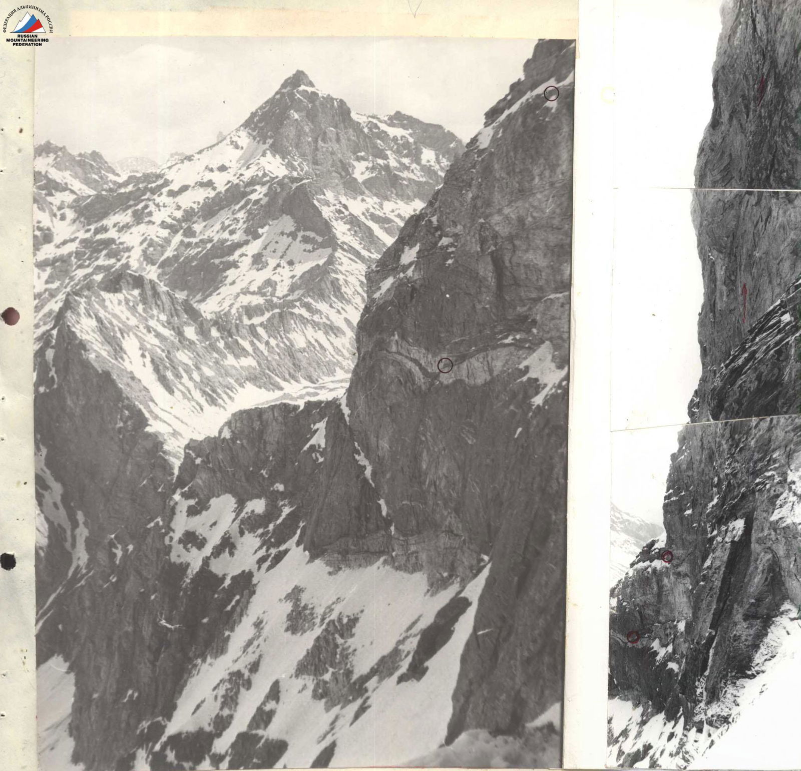
Profile photo of the wall on the right. Taken along the wall from the Grigorenko–Prigoda site on June 7, 1985. Industar 50. Morning. Common places on the photo. Industar 50. Morning. Object not available, photo not taken.

PHOTOPANORAMA OF THE ASCENT AREA. Taken from a distance of 5-6 km. June 25, 1985. "I"-50. Sign on scheme No. 3:
Brief overview of the ascent area
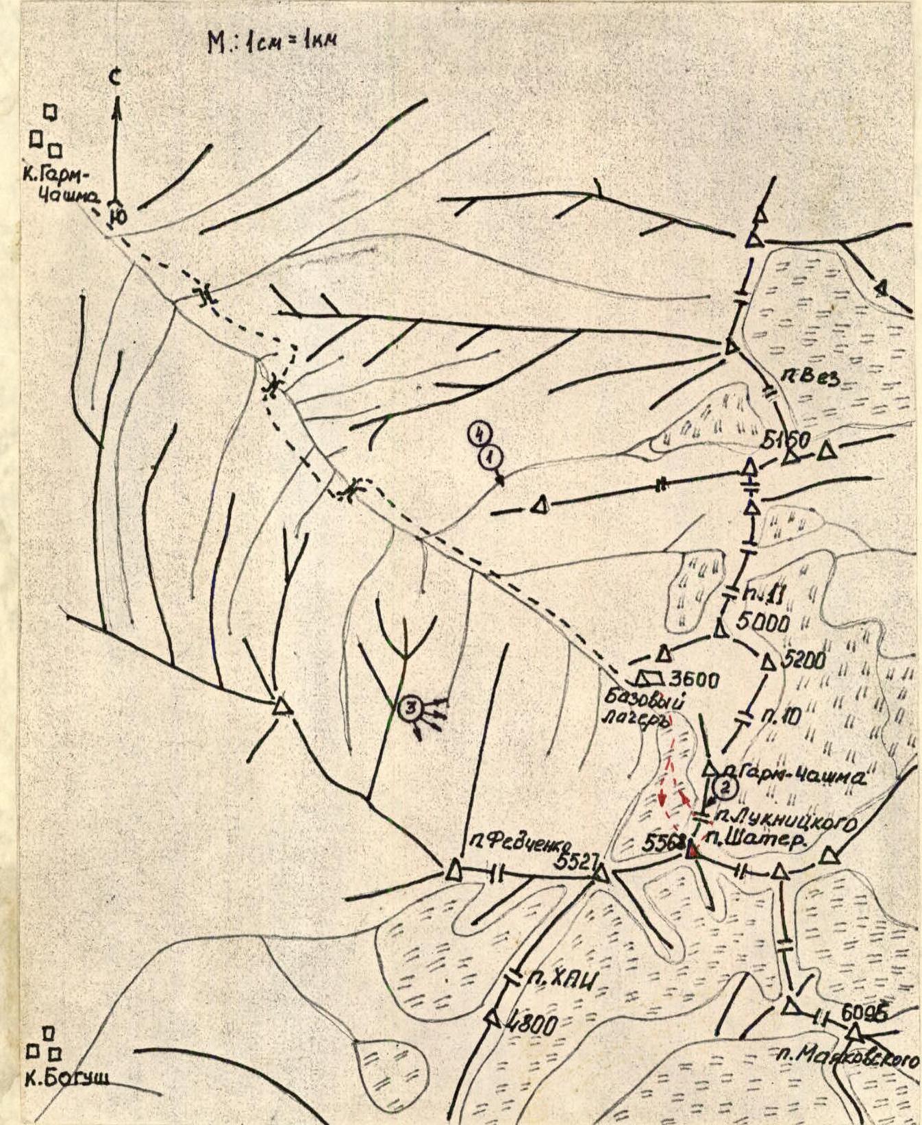
The Shater peak is located in the Ishkashimsky Range. To the northwest (in the Garm-Chashma gorge) the peak drops with a steep kilometer wall, located in the altitude range of 4300-5400 m. From the Garm-Chashma village to the upper reaches of the Garm-Chashma gorge it's 8-9 hours walk (about 30 km). At the same time:
- Up to the middle mark of the path, there is a good trail through the wooded terrain.
- Further (immediately after the turn of the gorge to the south) the trail goes through high-altitude grassland along the Garm-Chashma river.
Before us, in 1973-1975, two expeditions from the Ukrainian SSR (led by Grigorenko–Prigoda) worked in the area. A geographical description of the area and a detailed description of the approaches are given in the report of the Ukrainian SSR team (led by Grigorenko–Prigoda); 1st place in the 1973 USSR Championship.
Our team used a caravan for transporting equipment and supplies. Horses can be rented from the shepherds of the mid-valley pastures. Part of the cargo was delivered in advance by helicopters from Khorog.
The base camp was set up at an altitude of 3600 m on a large flat site, protected from the slope by a rocky moraine, on the right (orographic) bank of the Garm-Chashma river in its upper reaches. From the base camp to the wall — 2 h 24 min (this mark is given in the schemes of the Ukrainian SSR team as 3200 m).
From the base camp, the northwest wall of Shater peak and the neighboring grandiose peak 5527 (peak "Three Towers") with its unconquered northwest wall are clearly visible.
The weather in the area is usually stable, without precipitation. June of this year was unusually snowy, and only by July 4-6 did the wall take on a state close to the average summer conditions.
In terms of mountaineering capabilities, the area of the upper reaches of the Garm-Chashma gorge is suitable both for low-category climber training and for events involving CMS and MS.
In the adjacent cirques, first ascents are possible:
- 2A-5A category of difficulty
- On the NW wall of peak 5527 — first ascent of 5B category of difficulty.
The team's movement on the route was carried out in a mode that ensured the implementation of the tactical plan — 12-13 hours of work and 8 hours of night rest.
Daily, from the place of tent installation, a pair processed the route, which allowed:
- To increase the length of the route passed per day;
- To ensure a warm-up and "warming up" of the leading rope team on the day of work.
The team spent 56.8 climbing hours on the route.
Safety during work on the route was ensured by:
- regular change of leading rope teams;
- passing the rope on double rope;
- movement of the first climber on double rope and with an absorber;
- predominantly placing protection under overhangs.
The team had 2 sets of first-aid kits and spare food for the radio station. Despite the abundance of overhangs and cornices on the route, the team managed to pass it with minimal use of bolts (6 pcs.).
The main criterion for choosing bivouac sites was their protection from possible rockfall. It should be noted that the team used almost all convenient overnight stays on the route (i.e., safe overnight stays located under overhangs in the area of ledges).
As a result:
- Overnight stay 1 was under overhangs on ledges, allowing to set up a platform tent for 4 participants, and the other four to settle in bivouac bags (in hammocks).
- Overnight stays 2, 3, 4 were hanging.
As a result of the team's actions, the tactical plan of the ascent was fully implemented without deviations.
1st day. Main task — passing the lower part of the wall with a height difference of 500 m and reaching the main part of the wall with the organization of a bivouac at its lower third.
On sections:
- R0-R10, the Bалыberdin–Pozhidaev rope team went;
- R10-R17 — Glushkov–Zhak.
Sections R0-R10 were overcome by the first rope team in crampons. At 15:00, the team reached the planned overnight stay site.
On the same day, Shustrov–Ovsyannikov passed another 35 m (section R17-R18), this "rope length" is hanging and passed exclusively on artificial aids.
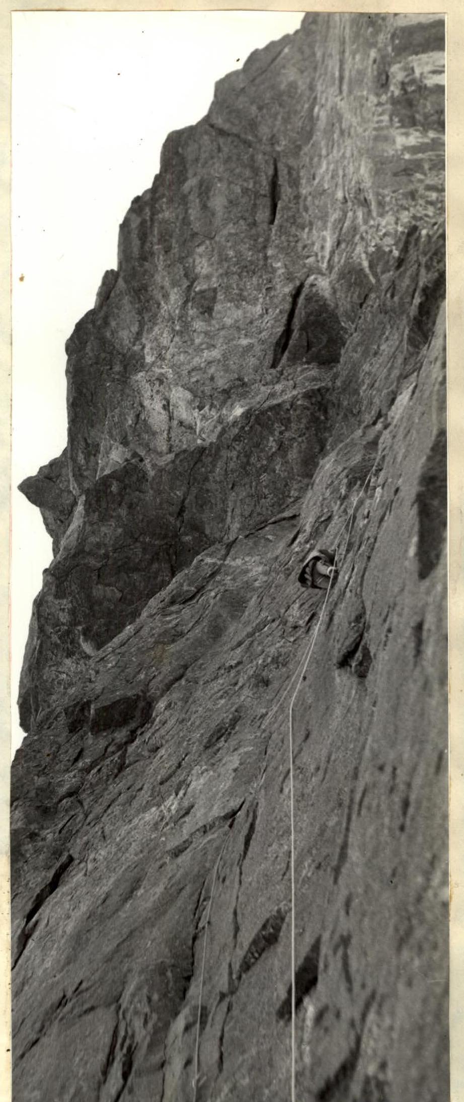
2nd day. Main task — overcoming the overhang with a limited number of cracks and reaching a bivouac at the base of a giant slab on the wall.
Sections R18-R24 were passed by the Bалыberdin–Pozhidaev rope team.
Climbing is extremely difficult with the use of artificial aids.
Processing of sections R23-R24 was carried out.
3rd day. Main task — reaching a bivouac at the base of the tower.
On sections:
- R24-R25, the Ovsyannikov–Aivazov rope team worked first;
- R25-R31 — Bалыberdin–Aivazov.
Processing of sections R27-R31 was carried out. Extremely difficult climbing, complicated by the fragility of the rocks. 1st key section.
4th day. Main task — overcoming a large cornice. It was not planned to change the bivouac site on this day.
Sections R31-R34 were passed by the Zhak–Glushkov rope team, sections R34-R38 — by the Shustrov–Bалыberdin rope team.
The most intense day of the ascent. The terrain is extremely difficult to pass. Work was carried out exclusively on artificial aids.
5th day. Main task — reaching the "roof" followed by an ascent to the summit.
Sections R38-R39 were passed by the Pozhidaev–Bалыberdin rope team.
Overcame an ice-filled internal angle.
At 16:00, the team was on the summit, and at 21:45 — at the base camp.
There were no falls or injuries on the route.
There were no missed radio communication sessions.
The weather during the entire ascent was good.
Passing the route contributed to the use of chocks such as:
- "friend";
- "hook-nog", as well as equipping the team with a platform tent.
| Section | Rock pitons | Chocks | Ice screws | Bolt pitons | Skyhooks | Height (m) | Steepness | Length (m) | Cat. diff. | Notes |
|---|---|---|---|---|---|---|---|---|---|---|
| R3 | 5 | 9 | - | - | - | 80° | 100 m | 5 | ||
| R4 | 3 | 2 | - | - | - | 55° | 30 m | 4 | ||
| R5 | 2 | - | - | - | - | 70° | 10 m | 5 | ||
| R6 | 5/4 | 3/2 | - | - | - | 90° | 10 m | 5 | ||
| R7 | - | - | 3 | - | - | 50° | 30 m | 4 | ||
| R8 | 1 | 1 | - | - | - | 70° | 10 m | 5 | ||
| R9 | - | - | 2 | - | - | 50° | 20 m | 4 | ||
| R10 | 2 | 2 | - | - | - | 90° | 10 m | 6 | ||
| R11 | 15/7 | 18/6 | - | - | - | 85° | 30 m | 5 | ||
| R12 | 8/4 | 6/2 | - | - | - | 110° | 20 m | 5 | ||
| R13 | 19/7 | 21/12 | - | - | - | 90° | 20 m | 6 | ||
| R14 | 14/8 | 16/2 | - | - | - | 75° | 40 m | 5 | ||
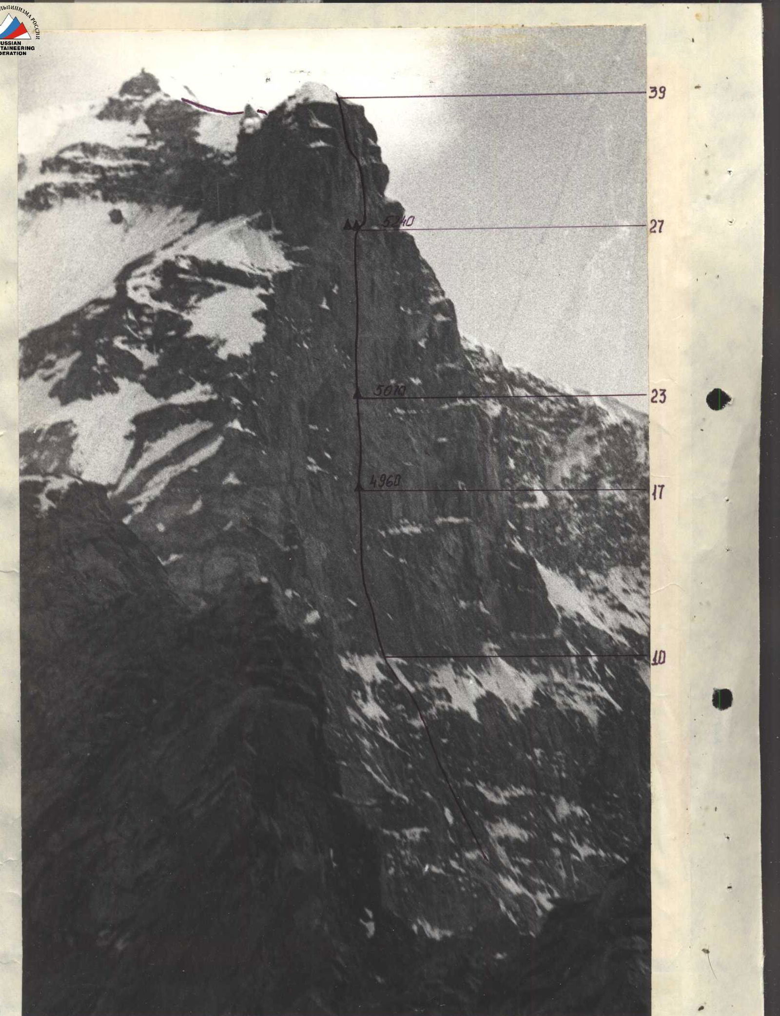
| R15 | 20/7 | 16/8 | - | - | - | 90° | 40 m | 6 | 14th camp | |
| R16 | 5/3 | 4/4 | - | - | - | 75° | 10 m | 6 | ||
| R17 | 21/18 | 14/10 | - | - | - | 4960 | 90° | 30 m | 6 | July 20, 1985 |
| R18 | 18/2 | 16/5 | - | 1/1 | 5 | 85° | 20 m | 6 | ||
| R19 | 13/4 | 11/7 | - | - | - | 80° | 30 m | 5 | ||
| R20 | 5/2 | 2/1 | - | - | - | 85° | 10 m | 5 | ||
| R21 | 3/2 | 4/4 | - | - | - | 90° | 10 m | 5 | ||
| R22 | 8/3 | 7/5 | - | - | - | 70° | 20 m | 5 | ||
| R23 | 18/9 | 19/8 | 1/1 | - | - | 5070 | 90° | 30 m | 6 | July 21, 1985 |
| R24 | 46/25 | 38/25 | - | 2/2 | 6 | 80° | 105 m | 6 | ||
| R25 | - | - | - | - | - | 75° | 30 m | 5 | ||
| R26 | 2 | - | - | - | - | 5240 | 65° | 10 m | 5 | July 23, 1985 |
| R27 | 13/5 | 8/4 | - | - | - | 5240 | 80° | 30 m | 5 | July 22, 1985 |
| R28 | 10/7 | 11/4 | - | - | - | 95° | 15 m | 6 | ||
| R29 | 14/9 | 6/4 | - | 4/1 | 1 | 95° | 10 m | 6 | ||
| R30 | 15/13 | 8/6 | - | - | - | 80° | 10 m | 6 | ||
| R31 | 4/4 | 2/2 | - | - | - | 90° | 5 m | 6 | ||
| R32 | 14/13 | 8/8 | - | - | - | 90° | 10 m | 6 | ||
| R33 | 8/8 | 12/12 | - | 1/1 | - | 95° | 15 m | 6 | ||
| R34 | 12/9 | 8/5 | - | - | - | 85° | 5 m | 6 | ||
| R35 | 11/8 | 9/6 | - | - | 4 | 85° | 15 m | 6 | ||
| R36 | 12/7 | 14/6 | - | - | - | 85° | 35 m | 5 | ||
| R37 | 18/6 | 14/9 | - | 3 | - | 5420 | 75° | 45 m | 5 | 12.5 hours |
| R38 | - | - | 2 | - | - | 5420 | 30° | 360 m | 2 | 12 hours |
| R39 | 18/6 | 14/9 | - | 5 | - | 5568 | 30° | 360 m | 2 | T. Hodoчас. |
Description of the route by sections
R0-R1. Hard snow with ice gutters. R1-R2. Destroyed wall, ice in crevices. R2-R3. Ram's foreheads with snow and ice. R3-R4, R4-R5, R5-R6. A series of destroyed rock walls and ridges. R6-R7. Takeoff with overhang, few crevices. R7-R10. Steep snowy slope with a steep wall. Under a thin layer of snow — hard ice. R10-R11. Vertical crevice, rocks destroyed. R11-R12. Internal angle with an overhang, which is bypassed on the left side. R12-R13. Up through a strongly dissected wall and traverse to the right. R13-R15. Left-up along a vertical wall and a wide internal angle. R15-R16. Traverse to the right and up the wall. The overhang is passed on the left. R16-R17. Up the internal angle and to the right on a wide (1 m) ledge. Overnight stay. R17-R18. The beginning of one of the key places on the route. From the overnight stay through the overhang up along a vertical internal angle with a large number of small cornices. After 30 m, exit under a wall with a cascade of cornices. R18-R19. Along the wall with cornices up and to the right. Few crevices. Passage with "skyhooks". R19-R20. Along the wall, exit to the base of an internal angle, looking like an etak from below. R20-R21, R21-R22, R22-R23. Along the internal angle up and slightly to the left under a vertical slab, above which a more gentle internal angle goes left-up. Along the internal angle, exit to a ledge. Under a cornice, overnight stay. R23-R25. From the overnight stay site to the left along large blocks under a large cornice above a niche. Traverse to the right under the cornice, exit to a blunt outer angle with small terrain. Along smooth walls with small overhangs and small crevices up and slightly to the right. Gradually, the terrain becomes larger, more crevices. R25-R27. Along the right edge of a large slab to its upper edge and along a simple internal angle to a ledge. Overnight stay. R27-R28. Up along a fault with a large number of loose rocks to the top of the fault. R28-R29. Traverse to the right along a ledge. Rocks are extremely fragile. It's extremely difficult to organize reliable protection. The most problematic section of the route. At the end of the ledge on a bolt piton — a control tur. R29-R30. Right-up along a ledge of fragile rocks, bypassing the overhang. R30-R31. Left-up along intermittent ledges. Rocks are fragile. R31-R33. Traverse to the right and further up along a crevice, which gradually narrows. Rocks are strong, smooth. R33-R37. Up under the left edge of a large cornice. The crevice ends. Up to the level of the second cornice, movement on bolt pitons or "skyhooks". Traverse to the left under the cornice along large crevices. R37-R38. Up first along the left, and then along the right wall of an internal angle. In the evening under a waterfall, in the morning along rime ice. Exit to a ledge with snow. R38-R39. Internal angle, steeper in the upper part. Exit to a wide ledge and to the left onto the summit ridge. R39-R40. Snowy ridge with outcrops of rocks and sections of steep ice. Cornices on the left. 1-2 pairs of crampons required.
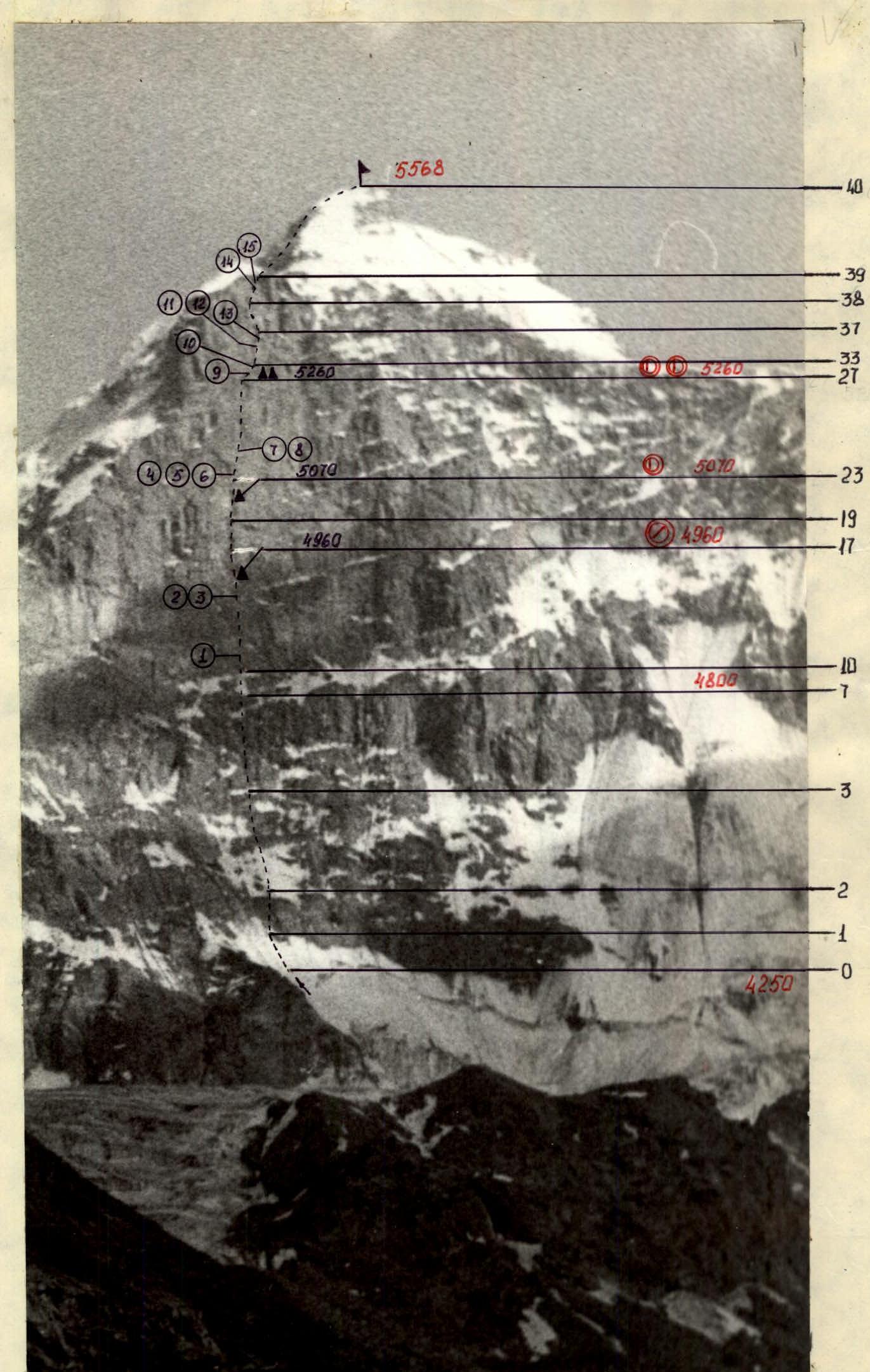
TECHNICAL PHOTOGRAPHY OF THE ROUTE. Taken on July 7, 1985, from a distance of 8 km. Height 4000 m. Time 17:00. Industar 50. Sign on scheme No. 4.
No. 5. Section R23-R24 on descent from processing.
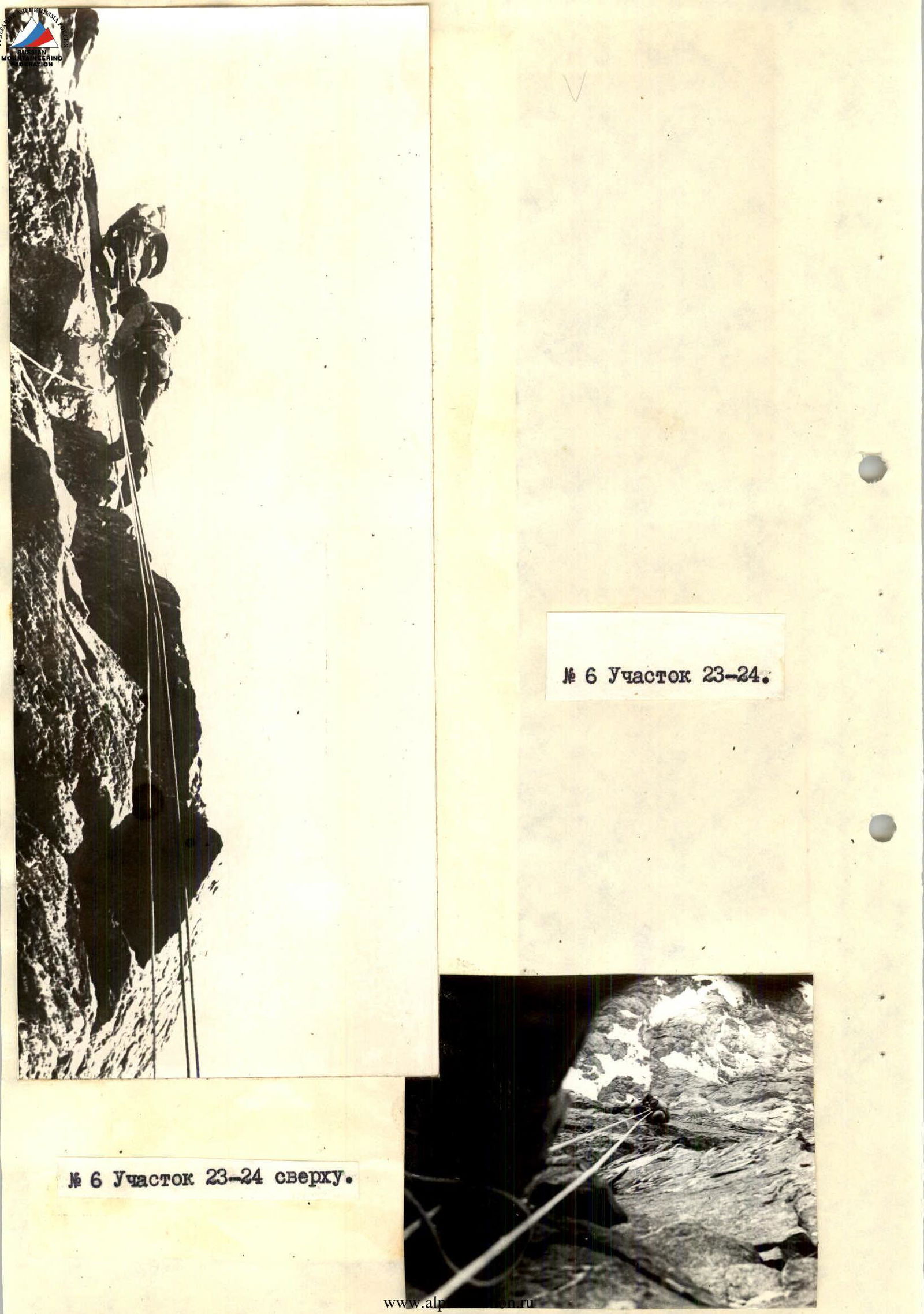 No. 6. Section R23-R24 from above.