
Report
The team of the Central Council of DSO "Mehnat" on the ascent of Peak Korzhenevskaya 7105 m via the central counterfort of the western wall in the program of the USSR Climbing Championship. Tashkent, 1980
Peak Korzhenevskaya is located in the North-Western Pamir in the northern spur of the Academy of Sciences Range. It was discovered in 1906 by N. L. Korzhenevsky. The summit was first conquered in 1953. By the present time, many interesting routes have been laid to the summit, including the western wall. The wall was first climbed in 1975 by our team, but as further study of the wall showed, the route taken was objectively dangerous in its lower part, which was dramatically confirmed on July 28 when a massive rockfall occurred down the central couloir.
This year, three teams declared their intention to climb the western wall. We chose the safest option - to ascend via the central, indistinctly expressed counterfort. Additional research was conducted on the route, a scheme was drawn up, and the pattern of rockfalls was studied, with overnight stops planned.
The team believes that such wall routes should be climbed by small groups, so it was decided to proceed with six climbers. To replenish the team with young participants, additional entries were made.
The team consisted of:
- Putinchev A.V. - MS, team captain
- Voronin V.T. - MS
- Gromov L.V. - MS, deputy captain
- Gromov A.V. - CMS
- Zanutdinov G.S. - CMS
- Sergeev A.N. - CMS
All participants had excellent acclimatization gained from ascents of Peak Lenin and Peak Korzhenevskaya, and had been participating together in climbs of various categories for several years, conducting regular year-round training.
The rest of the expedition team provided observation support for the climbing team.
Tactical Plan
During detailed study of the route, the following tactical plan was developed:
- Day 1 - Base Camp to observation camp on Soldierov Glacier
- Day 2 - Observation camp to top of rocky outcrop under the "bull"
- Day 3 - Climbing the "bull"
- Day 4 - Climbing the first rocky belt
- Days 5-6 - Climbing the second rocky belt
- Day 7 - Summit push and descent to 6400 m
- Day 8 - Descent to Base Camp.
The tactical plan included daily processing of the further route: the second climber would remove some intermediate pitons, straightening the rope, which the rest of the team would then follow using jumar ascenders. On difficult, steep sections, a "fishing rod" was used to pull up the backpack. As the team progressed, the freed rope and hardware were passed up.
During the ascent, there were changes to the tactical plan due to bad weather: After waiting out bad weather under the "bull," due to significant ice formation on the rocks, it was decided to dedicate a day to processing the route and returning to a comfortable campsite. The same decision was made for overcoming the first rocky belt. Further work proceeded according to plan. The descent to Base Camp was carried out on the day of the summit push, indicating a significant reserve of strength.
In detail, the tactical plan was fully executed.
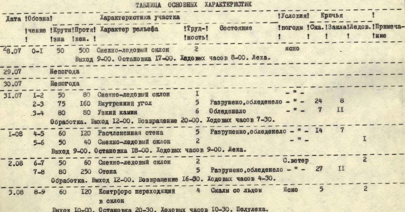
Table of Main Characteristics
| Date | Designation | Steepness | Length | Nature of Terrain | Difficulty | Condition | Weather Conditions | Rock Pitons | Ice Pitons | Notes |
|---|---|---|---|---|---|---|---|---|---|---|
| 28.07 | R0–R1 | 50° | 500 m | Snow-ice slope | 2 | Clear | ||||
| Departure 9:00. Stop 17:00. Moving hours 8:00. Lying. | ||||||||||
| 29.07 | Bad weather | |||||||||
| 30.07 | Bad weather | |||||||||
| 31.07 | R1–R2 | 50° | 80 m | Snow-ice slope | 1 | "—" | ||||
| R2–R3 | 75° | 160 m | Inner corner | 5 | Destroyed, iced | "—" | 24 | 8 | ||
| R3–R4 | 80° | 80 m | Narrow chimney | 6 | Iced | "—" | 7 | 11 | ||
| Processing. Departure 12:00. Return 20:00. Moving hours 7:30. | ||||||||||
| 01.08 | R4–R5 | 60° | 120 m | Dissected wall | 5 | Destroyed, iced | "—" | 14 | 7 | |
| R5–R6 | 50° | 40 m | Snow-ice slope | 2 | "—" | I | ||||
| Departure 9:00. Stop 18:00. Moving hours 9:00. Lying. | ||||||||||
| 02.08 | R6–R7 | 50° | 60 m | Snow-ice slope | 2 | N. wind | 2 | |||
| R7–R8 | 80° | 250 m | Wall | 5 | Destroyed, iced | "—" | 27 | 11 | ||
| Processing. Departure 12:00. Return 16:30. Moving hours 4:30. | ||||||||||
| 03.08 | R8–R9 | 60° | 120 m | Counterfort turning into slope | 4 | Rocks with ice | Clear | 5 | 2 | |
| Departure 10:00. Stop 20:30. Moving hours 10:30. Half-lying. | ||||||||||
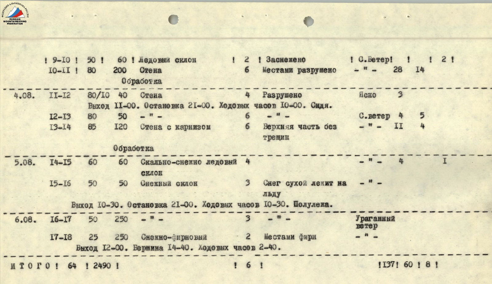
| 04.08 | R9–R10 | 50° | 60 m | Ice slope | 2 | Snow-covered | N. wind | 12 | 1 | |
| R10–R11 | 80° | 200 m | Wall | 6 | Partly destroyed | "—" | 28 | 14 | ||
| Processing | ||||||||||
| R11–R12 | 80/10° | 40 m | Wall | 4 | Destroyed | Clear | 3 | |||
| Departure 11:00. Stop 21:00. Moving hours 10:00. Sitting. | ||||||||||
| R12–R13 | 80° | 50 m | "—" | 6 | "—" | N. wind | 4 | 5 | ||
| R13–R14 | 85° | 120 m | Wall with cornice | 6 | Upper part without cracks | "—" | 11 | 4 | ||
| Processing | ||||||||||
| 05.08 | R14–R15 | 60° | 60 m | Rocky-snow-ice slope | 4 | "—" | 4 | 1 | ||
| R15–R16 | 50° | 50 m | Snow slope | 3 | Dry snow on ice | "—" | ||||
| Departure 10:30. Stop 21:00. Moving hours 10:30. Half-lying. | ||||||||||
| 06.08 | R16–R17 | 50° | 250 m | "—" | 3 | Hurricane-force wind | ||||
| R17–R18 | 25° | 250 m | Snow-firn | 2 | Partly firn | "—" | ||||
| Departure 12:00. Summit 14:40. Moving hours 2:40. | ||||||||||
| TOTAL | 64° | 2490 m | 6 | 137 | 60 | 8 |
Brief Explanation of the Table
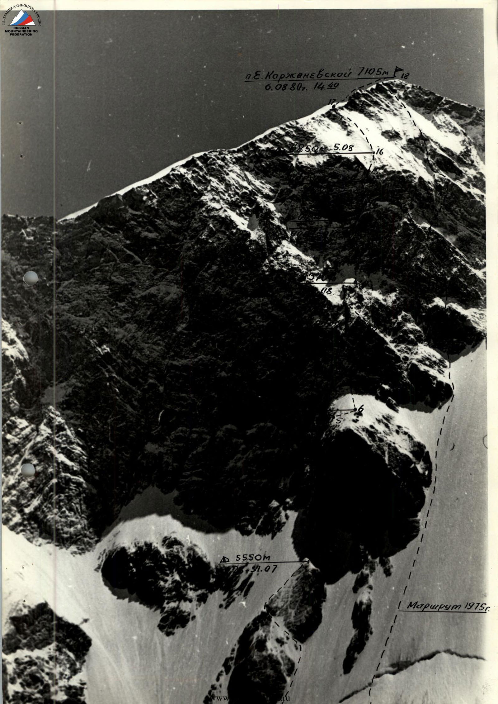
July 28. At 9:00, the team left the observation camp on Soldierov Glacier. At 13:00, the team approached the bergschrund, from where the route begins.
After crossing the bergschrund via a thin, fragile bridge, they reached a snow slope (section R0–R1). A layer of snow 5 to 50 cm thick lies on the ice. Cramp-ons were used for climbing.
Along the right edge of the rocky outcrop, under its protection, they ascended to the couloir cutting through this outcrop, then moved strongly left, crossed the couloir, and reached its left flank, continuing upwards to the highest point of the rocky outcrop, where they dug a platform for the night in the ice and small frozen talus.
July 29-30. Bad weather. The team stayed in place for two days.
July 31. Gromov A., Zaynutdinov G., and Putinchev A. set out for processing at 12:30. From the tent, a snow slope (section R1–R2) leads to the base of the "bull." Behind the left edge of the "bull," a large inner corner (section R2–R3) leads upwards, ending in a cornice. Under the cornice, a series of ledges allows for a sharp traverse left towards a narrow chimney-crack (section R3–R4) in a smooth slab. The rocks were abundantly iced and powdered with snow. After securing the ropes, the trio descended for the night.
August 1. Gromov L. proceeded from the end of the processed part of the route. Section R4–R5 consists of a series of small counterforts and couloirs; the rocks are very much destroyed. Significant icing of the rocks somewhat limited rockfall but complicated progress. After traversing a snow slope (section R5–R6), they dug a normal tent platform. Sections R2–R4 were climbed using a "fishing rod."
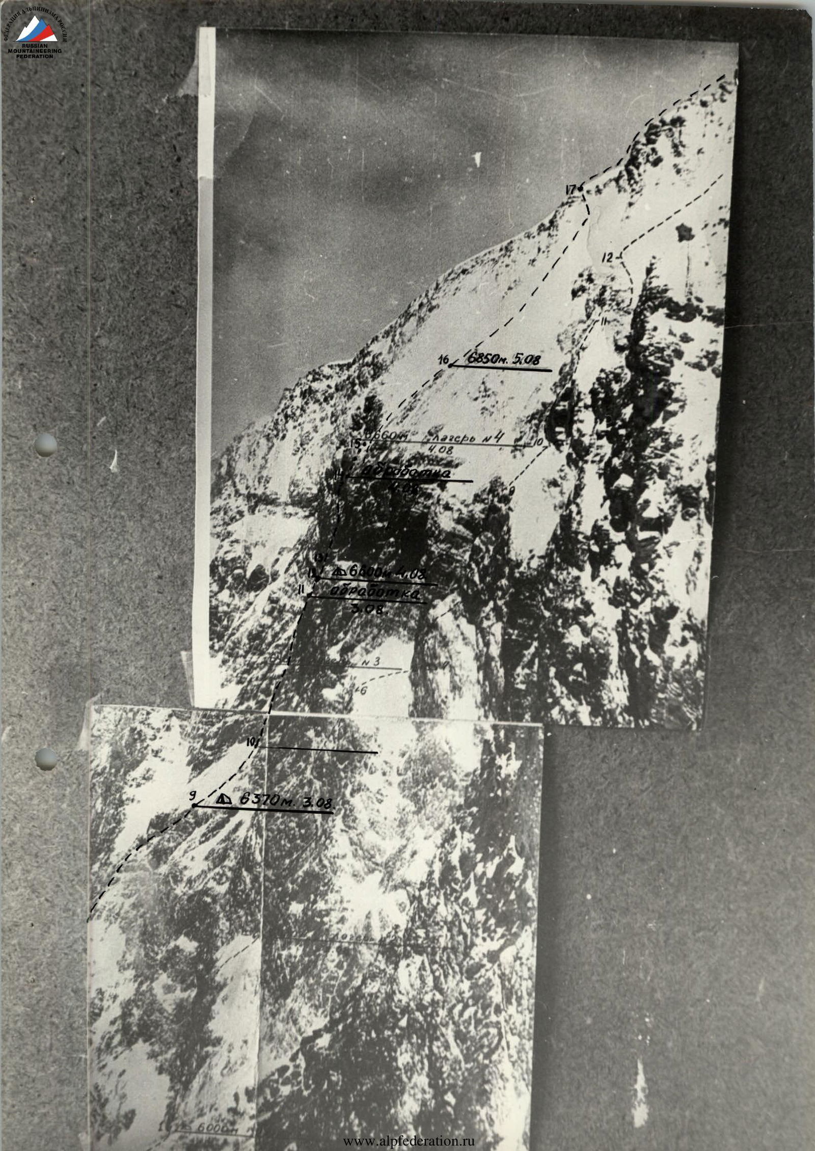
August 2. Gromov A. and Putinchev A. went out for processing. From the tent, a snow slope (section R6–R7), closer to the rocks, turns into an ice slope. The rocky wall (section R7–R8) is heavily destroyed, representing an indistinctly expressed counterfort. In the upper part, an inner corner to the right leads up to the first rocky belt. Icing remained significant.
August 3. Gromov L. and Zaynutdinov G. worked further. Upwards and left along rocky outcrops-walls interspersed with snowy belts (section R8–R9). The section ends with a belt of tuff conglomerates with very limited cracks. Climbing was complex. On section R7–R8, a "fishing rod" was again used to pull up backpacks. The duo Gromov A. and Putinchev A. went out for further processing. The others worked on building a platform.
An ice slope (section R9–R10) leads to the second rocky belt. Section R10–R11 consists of a series of chimneys leading to an overhanging wall, after which one reaches the right flank of a couloir. The chimneys were iced. The lower chimney was exposed to rockfall, but further on, it was quite safe. After securing the ropes, the duo descended to a prepared campsite.
August 4. The same duo went up lightly to continue work. The others were engaged in pulling up backpacks and preparing the campsite, and later, in bringing up ropes and hardware. Sergeev A. was busy rigging horizontal ropes to the left towards the chosen campsite (section R11–R12).
From the end of the processed section, along the outer corner of the right flank of the counterfort (section R12–R13), leading to the wall (section R13–R14). In the middle part of the wall, there is a cornice cut by a chimney. The entry into the overhanging chimney was very complex. Above the chimney, there is a huge overhanging "gendarme" bypassed on the left. Again, a belt of tuff conglomerates with almost no cracks. Very complex.
After securing the ropes, everyone descended to a prepared campsite. It was not possible to set up a tent; they spent the night sitting on two ledges, three people each.
August 5. Together, they worked on pulling up backpacks. At such heights and on such steep slopes, it was very difficult.
From the end of the processed section, through medium rocks interspersed with loose snow (section R14–R15), they reached a snow slope (section R15–R16). The snow was dry and very loose; in places, it was scraped off down to the ice during the ascent. Moving right to a snowy ridge, they dug a campsite.
August 6. Due to hurricane-force winds, they departed late. The same snow slope (section R16–R17), with some crust appearing in the upper part. They climbed simultaneously. The slope ends with small, destroyed rocks leading to the snowy-firn summit ridge (section R17–R18). Further along the ridge to the summit. At 14:40, the team reached the summit. Hurricane-force winds. They immediately began their descent. On the same day, the team descended to Base Camp.
Additional Data
The team members have a wealth of experience in high-altitude wall ascents. The team considers this route more challenging than all previously climbed. In character, the route can be compared to the 1975 route on the same wall, but it is much more complex; and to the route on Peak Revolution via the center of the NNW wall, but it is more complex, longer, and much colder.
The team's initial weight was 127 kg, with food constituting 23 kg. For the first three days, the rations were 780 g/person·day, and for the remaining seven days, 215 g/person·day.
The small quantity and poor quality of photographic materials are due to the fact that the photographs were taken with slide film, following the loss of the camera with the main black-and-white film.