Report
On the ascent of Peak Korzhenevskaya via the northern part of the western wall by the combined team of CS FC and S.
Team captain I.G. Khatskevich, team coach V.P. Popov
1974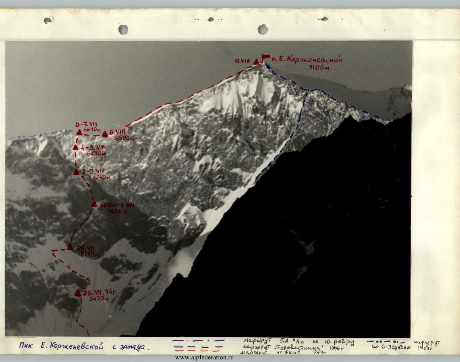
Peak Korzhenevskaya from the west.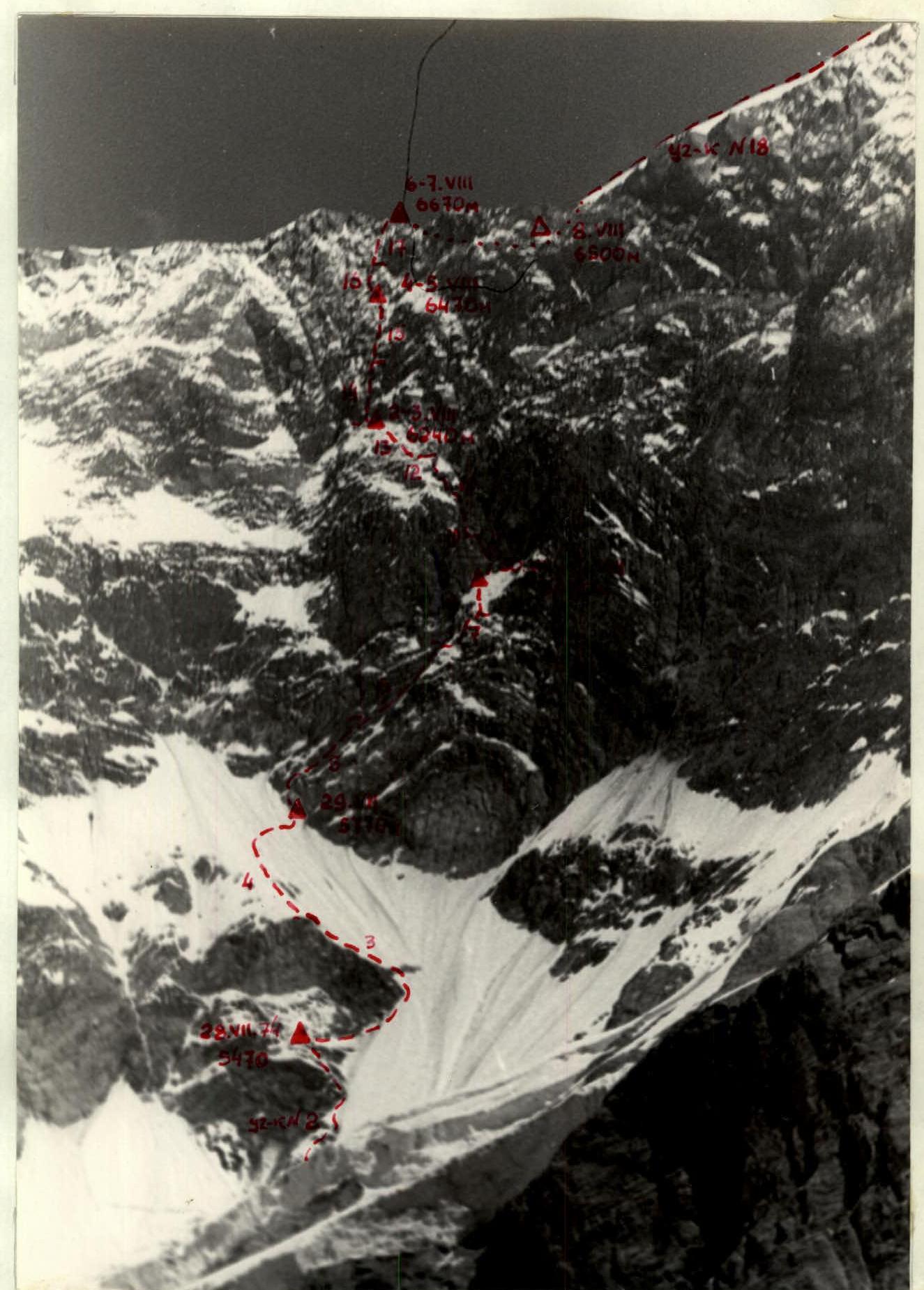
The left (northern) part of the western wall. The region of Central Pamir with its highest peaks in the USSR - Peaks "Kommunizma" and "Korzhenevskaya" - constantly attracts the attention of both domestic and foreign mountaineers.
The climbers of the Central Council of Physical Culture and Sports set a goal to climb and filed an application to participate in the XXII USSR Alpine Championship in 1974 via the western wall of Peak Korzhenevskaya in the high-altitude ascent class and traverse of Peaks Korzhenevskaya - Kommunizma.
The combined team of CS FC and S started the traverse, with the initial section being the left (northern) part of the western wall of Peak Korzhenevskaya.
Unfavorable weather conditions combined with the high complexity of the wall section of the route required spending more time and effort.
The death of V.F. Maltsev - a participant and coach of our expedition, captain of the team climbing via the center of the western wall to Peak Korzhenevskaya, which we learned about upon descending from Peak Korzhenevskaya, did not allow us to continue the planned traverse.
The route via the left (northern) part of the western wall, completed by the combined team of CS FC and S, is, in our opinion, a logically completed and interesting route from a sports perspective, consistent with the submitted application. In this regard, it was deemed possible to submit this report on the ascent to the USSR Alpine Federation for consideration as part of the 1974 championship in the high-altitude class.
Team captain MS Khatskevich I.G.
Geographical description and sports characteristics of the ascent object.
Peak Evgenia Korzhenevskaya (7105 m) is located in the Central Pamir, in a spur of the Academy of Sciences range. The area is characterized by significant glaciation and snow cover, as well as stable weather or bad weather. The fourth highest seven-thousander in the Soviet Union, first conquered in 1953. In recent years, it has attracted a large number of climbers. Routes have been laid along its ridges and walls from all sides, mostly of 5B category difficulty (routes passed as part of the USSR Championship participation).
The western wall faces a narrow cirque, sandwiched between the southern rib, along which the popular 5A category difficulty route passes, and the NW ridge - the path of the first ascenders.
The wall is a rocky scarp of kilometer-long extent, located at an altitude of 5700-6700 m.
The first and only route on its right (southern) part was climbed in 1966 by the "Burvestnik" team led by L. Dobrovolsky.
In sports terms, the wall is very rich: it allows for several new interesting routes of the highest category of difficulty.
Participating in the 1974 USSR Championship, the CS FC and S team chose to climb the left (northern) part of the western wall, leading to the NW ridge, as the initial section of the traverse of Peak Korzhenevskaya - Peak Kommunizma, but due to circumstances, they had to limit themselves to ascending Peak Korzhenevskaya.
Participants of the ascent
The combined team of CS FC and S consisted of 7 people:
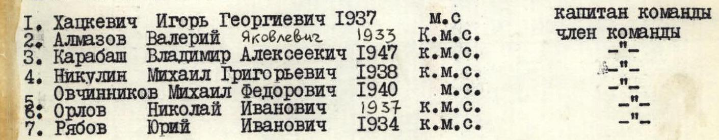
All participants, except Karabash, are instructors from "Dzhailyk" a/camp, who have known each other for a long time, having experience in joint instructional work and ascents. The core consists of members of the camp team, participants in the 1973 USSR Championship.
Preparation for the ascent. Preparation for the ascent to the peak in the Central Pamir region is preparation for an expedition. Extensive and meticulous work began in November 1973 on selecting equipment and supplies, assembling the team composition, and auxiliary participants.
Before the start of the expedition (July 1), some team members managed to visit the mountains - to work as instructors or to acclimatize and complete several ascents.
During the expedition, acclimatization exits were made:
- to Peak Chetyrekh (6300 m) - M. Ovchinnikov and N. Orlov - July 20, 1974.
- to Peak Parashyutistov (6100 m) - July 19, 1974, by the rest.
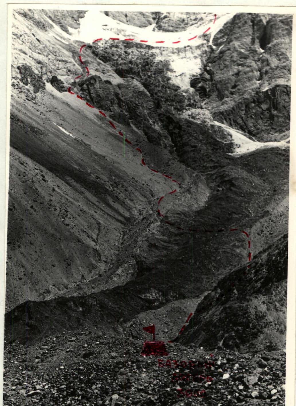
Directly before the ascent on July 23, 1974, on the second stage of the icefall of the western wall cirque, the first assault camp was set up (altitude 4700 m), where products and equipment necessary for the ascent to Peak Korzhenevskaya were transported.
Route description
From the base camp, located behind the right moraine of the Moskvin glacier, along the left side of the cirque glacier covered with scree, the ascent takes 40 minutes followed by crossing the glacier.
Along the moraine and further along the scree slopes to the right of the glacier - the approach to the sheer rock wall at the icefall of the first stage (1 hour 20 minutes).
The wall is bypassed via the "ram's foreheads" to the left (in the direction of travel) from the stream flowing in the couloir, then along the stream and soft, destroyed rocks - exit to the gentle part of the 1st stage (50 minutes).
Keeping away from the slopes on the left, where ice avalanches are possible along the middle part of the glacier, facing forward - ascent to the 2nd stage, leaving its ice drops to the left (1 hour 30 minutes) - to the site of the first assault camp.
From it, to the right upwards along the center of the glacier and further facing forward along the snow with a steepness of 50° - ascent to its 3rd stage (possible overnight location) (3 hours).
Further to the left upwards, traversing avalanche cones of loose and deep snow and overcoming the bergschrund via a bridge, ascent to the rock outcrops (2 hours).
Along them - to the base of a large rock promontory.
Throughout, orographic sides are implied unless specified otherwise. From the overnight location, traverse to the right to the base of the rock island wall along destroyed rocks and loose snow for 60 m (R2).
Further ascent to the island to the right along slabby rocks, iced and snow-covered (120 m), steepness 50°, 4B category difficulty (R3). Difficulties with piton insurance, alternating movement.
Above the island is a snowy slope. Ascent straight up along the snowy ridge and further traverse to the right under the base of the rock wall for 300 m, 40°, 2B category difficulty (R4). Simultaneous ascent, traverse alternating. Insurance via ice axes and pitons at the base of the wall.
Third assault camp.
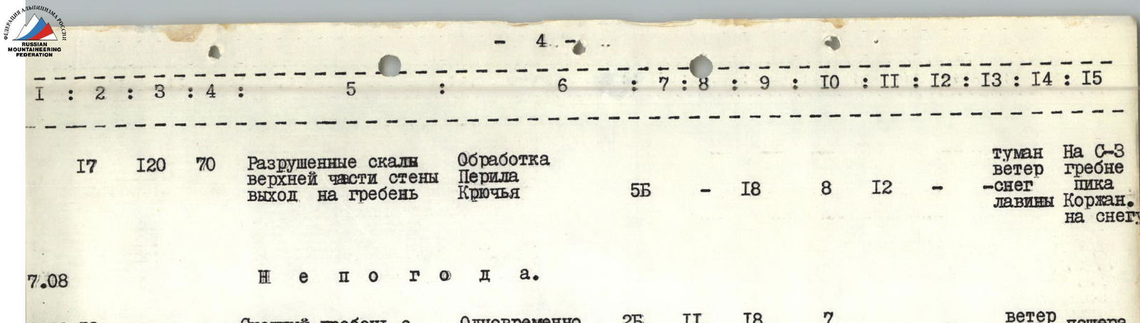
Further up to the right along the rocks of the lower part of the wall (120 m, 60°, 4B category difficulty, R5). Rocks are heavily destroyed, with individual "live" blocks encountered. All are in snow, местами обледенело. The path passes through a system of outer corners, gutters, sheer 3-5 m walls and leads to a large snow-ice couloir, along which powder avalanches often occur, insurance via bends and pitons. It is necessary to move along the rocks to the left of the couloir, which are similar in character to the previous sections but more complex (160 m, 65°, 5A-5B category difficulty, R6). Sections R5-R6 were pre-processed, and fixed ropes were hung on them.
The route leads to a wall (80 m, 80-85°, 5B category difficulty, R7), which is overcome by free climbing with piton insurance. Fixed ropes. On the last sheer section of 20 m, backpacks are pulled up. Above is a large snowy ledge-slope (80 m, 45°, 4A category difficulty, R8), in the upper part of which, under the rock wall, is the overnight location - the first bivouac on the wall, the fourth on the route.
The wall above the fourth bivouac (100 m, 90°, 6 category difficulty, R9) - the most complex section of the route, has a slabby structure, very difficult for climbing and organizing insurance.
From the bivouac:
- First, to the right upwards along the snow to the couloir under the overhanging rock - the starting point for overcoming the wall. Rockfall is possible from above.
- 40 m upwards to the left of the couloir.
- Then to the right upwards to a narrow chimney 10 m.
- Ascent along the chimney for 50 m.
- Horizontal traverse to the left (40 m, 50°, 5A category difficulty, R10) followed by a 10 m ascent.
Sections R9-R10 were processed. Fixed ropes, piton insurance.
Above:
- Destroyed, steep rocks with very loose and deep (up to 1.5 m) snow (120 m, 65°, 5B category difficulty, R11).
- Fixed ropes, piton insurance and via bends.
Further:
- Traverse to the left (40 m, 50°, 4B category difficulty, R12).
- Upwards along the steep snowy slope with individual rock outcrops in the direction of the rock wall, under which is the bivouac site (60 m, 45°, 4B category difficulty, R13).
- Insurance via ledges. Fixed ropes.
From the bivouac:
- To the left upwards - steep rocks with snow, individual sections with ice (120 m, 70°, 5B category difficulty, R14).
- First, a sheer monolithic wall 40 m with small ledges and cracks.
- Then a small flattening with snow.
- After - upwards to the left into an iced chimney 15 m with smooth monolithic sheer walls.
- Above - traverse to the left along a sheer wall with unstable rocks 15 m.
- Then upwards - steep, heavily snowed rocks for another 50 m.
- The entire section R14 was pre-processed, with fixed ropes hung on it.
- Piton insurance.
Further:
- A rock wall of the same type, but steeper (120 m, 80°, 5B category difficulty, R15).
- It is necessary to move along shallow gutters on hand and footholds.
- Everything is clogged with snow, powder avalanches often occur.
- As before - pre-processing, piton insurance, fixed ropes.
The wall ends with a small snowy slope under an overhanging monolithic wall, where the next bivouac is located.
To the left of the bivouac:
- Rocks of the "ram's foreheads" type, covered with snow and flow ice (80 m, 80°, 5B category difficulty, R16).
- Above which begin the destroyed rocks of the upper part of the wall (120 m, 70°, 5B category difficulty, R17).
- Rocks are steep, brittle, very difficult to organize insurance.
- Along them (after pre-processing) - exit to the NW ridge.
Bivouac. The ridge is wide, snowy. местами -5 m.
From the exit point:
- First, descent for 200 m to the lowering of the ridge.
- Then - to the summit.
Descent via the 5A category difficulty route.
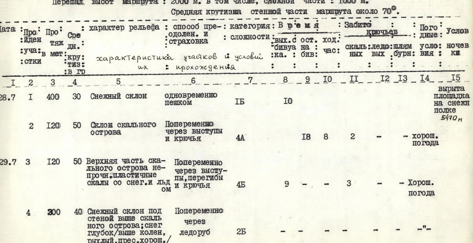
Table of main characteristics of the route to Peak Korzhenevskaya
via the northern part of the western wall
Route height difference: 2000 m, including complex section: 1000 m. Average steepness of the wall section of the route is about 70°.
| Date | Section | Section height | Average steepness | Terrain character | Method of overcoming and insurance | Category difficulty | Time | Number of pitons driven | Weather | Overnight conditions |
|---|---|---|---|---|---|---|---|---|---|---|
| reached | in meters | in degrees | Characteristics of sections and conditions | |||||||
| steepness | ||||||||||
| R1 | 28.07 | 1 | 400 | 30 | Snowy slope | Simultaneously on foot | 1B | 10 | – | – |
| R2 | 120 | 50 | Slope of the rock island | Alternating via ledges and pitons | 4A | 18 | 8 | 2 | ||
| R3 | 29.07 | 3 | 120 | 50 | Upper part of the rock island: unstable, plastic rocks with snow and ice | Alternating via ledges, bends, and pitons | 4B | 9 | – | 3 |
| R4 | 4 | 300 | 40 | Snowy slope under the wall above the rock island; snow deep (above knees), loose, good | Alternating via ice axe | 2B | – | – | – | |
| R5 | 30.07 | 5 | 120 | 60 | Rocks of the lower part of the wall: destroyed, individual blocks, all in snow and with ice. | Processing. Fixed ropes. Piton and via bends insurance. | 4B | 18 | 8 | 6 |
| 2 | 4 for bivouac | |||||||||
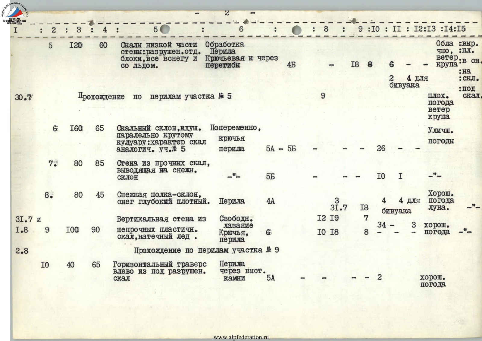
| R6 | 6 | 160 | 65 | Rocky slope parallel to the steep couloir: rock character similar to R5. | Alternating, pitons, fixed ropes. | 5A-5Б | – | – | 26 | |
| R7 | 7 | 80 | 85 | Wall of solid rocks leading to a snowy slope | 5Б | – | – | 10 | ||
| R8 | 8 | 80 | 45 | Snowy ledge-slope, snow deep, dense. | Fixed ropes. | 4А | 3 | 4 | 4 for bivouac | |
| 31.07 | 18 | |||||||||
| R9 | 31.07 and 01.08 | 9 | 100 | 90 | Vertical wall of unstable plastic rocks, flow ice. | Free climbing. Pitons, fixed ropes. | 6 | 10 | 18 | 7 |
| R10 | 02.08 | 10 | 40 | 65 | Horizontal traverse to the left from under destroyed rocks | Fixed ropes via protruding stones. | 5А | – | – | 2 |
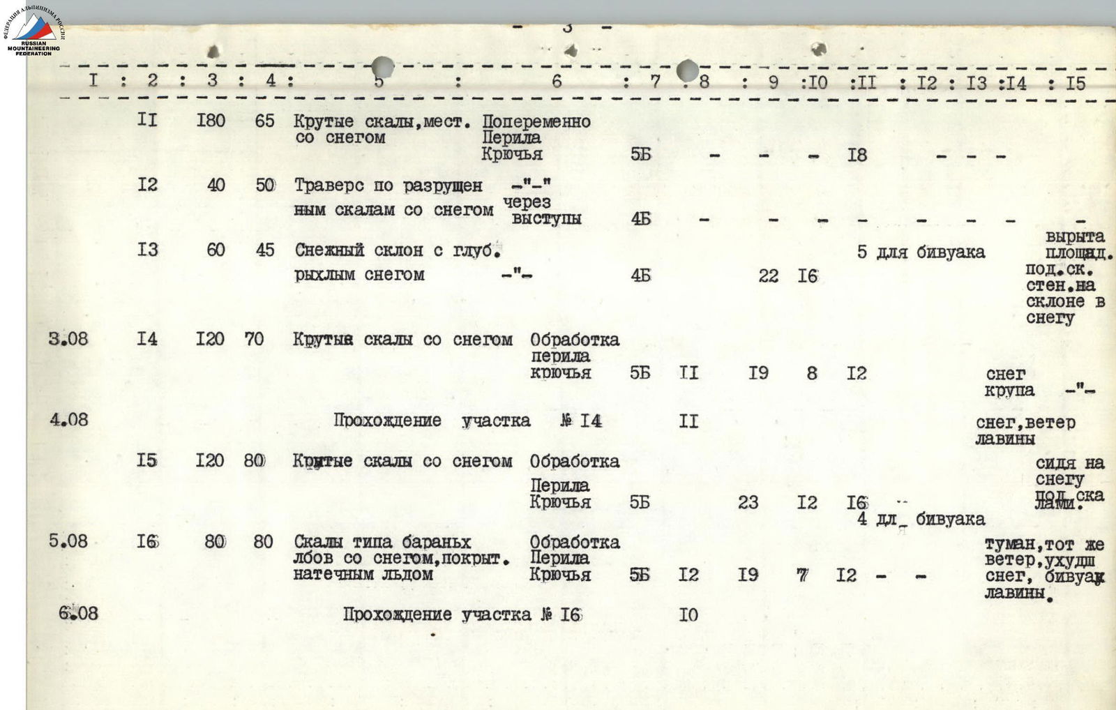
| R11 | 03.08 | 11 | 180 | 65 | Steep rocks, местами со снегом | Alternating. Fixed ropes. Pitons. | 5Б | – | – | 18 |
| R12 | 12 | 40 | 50 | Traverse along destroyed rocks with snow | –"– via ledges | 4Б | – | – | – | |
| R13 | 13 | 60 | 45 | Snowy slope with deep loose snow | –"– | 4Б | 22 | 16 | – | |
| R14 | 03.08 | 14 | 120 | 70 | Steep rocks with snow | Processing. Fixed ropes. Pitons. | 5Б | 11 | 19 | 8 |
| R15 | 04.08 | 15 | 120 | 80 | Steep rocks with snow | Processing. Fixed ropes. Pitons. | 5Б | 23 | 12 | 16 |
| R16 | 05.08 | 16 | 80 | 80 | Rocks of "ram's foreheads" type with snow, covered with flow ice | Processing. Fixed ropes. Pitons. | 5Б | 12 | 19 | 7 |
| R17 | 06.08 | Passage of section R16 | 10 | |||||||
| R17 | 07.08 | 17 | 120 | 70 | Destroyed rocks of the upper part of the wall. Exit to the ridge. | Processing. Fixed ropes. Pitons. | 5Б | – | 18 | 8 |
| R18 | 08.08 | 18 | 1500 | 35 | Snowy ridge with crevasses. | Simultaneously. | 2Б | 11 | 18 | 7 |
| 09.08 | 11 | 18 | 7 | |||||||
| R19 | 10.08 | Descent via the route | 5А | 10 | 17 | 7 | ||||
| 11 | 19 | 8 | ||||||||
| Total | 130 | 153 | 1 | 3 |
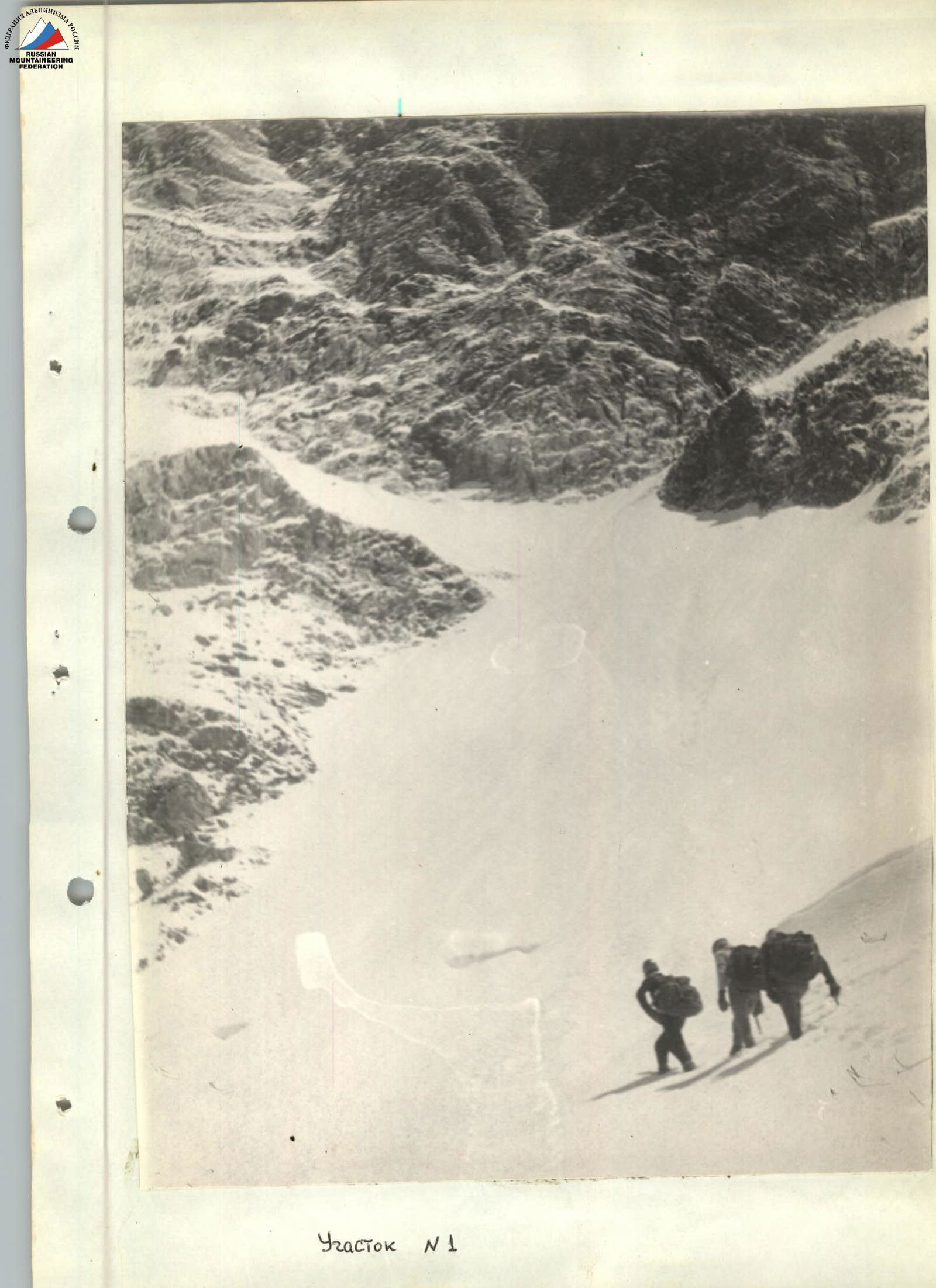
The lower part of the cirque of the western wall of Peak Korzhenevskaya.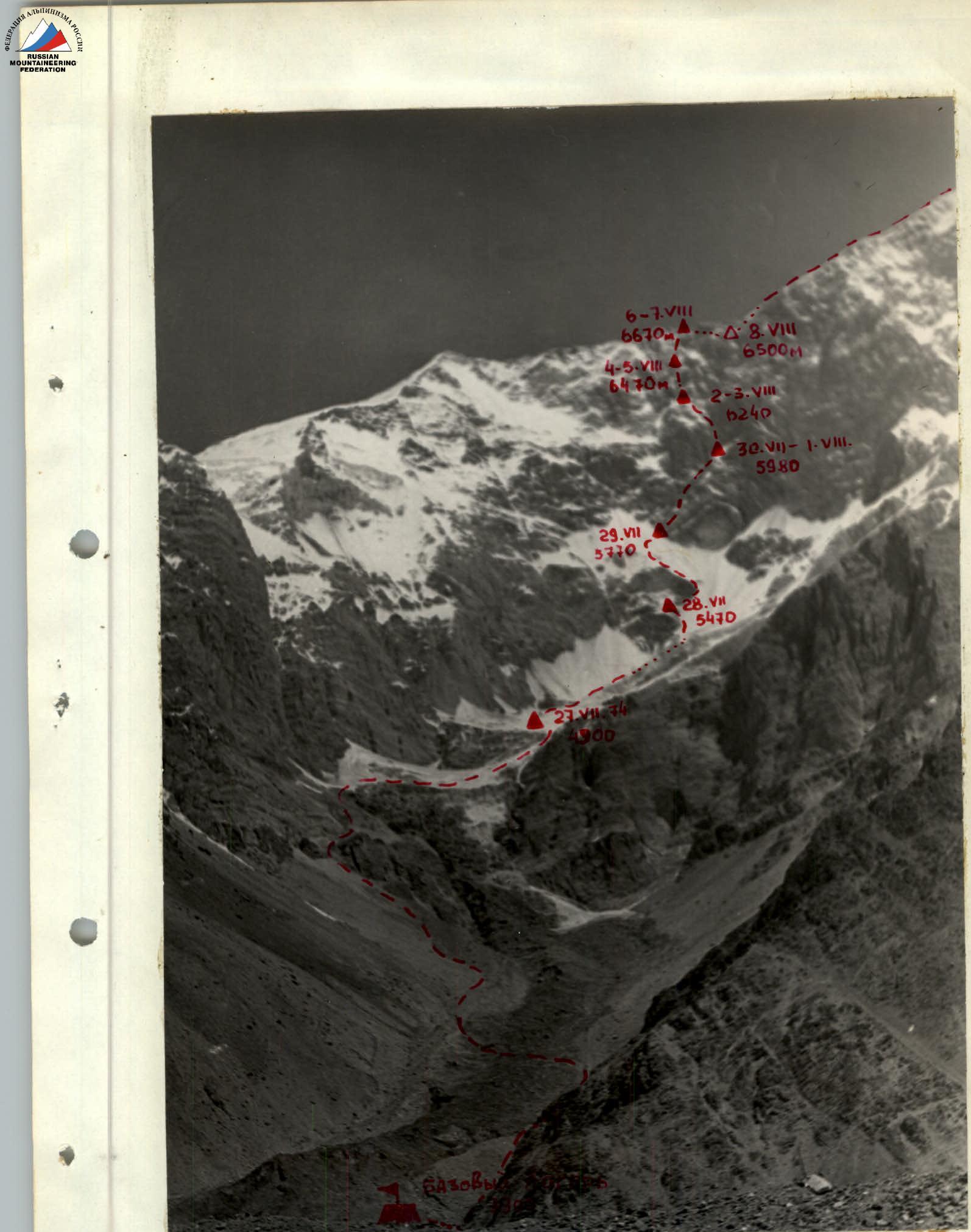
Cirque of the West. wall of p. Korzhenevskaya.