
70 Б13
GEORGIAN ALPINE CLUB
named after A. DJAPARIDZE
ASCENT TO PEAK EVGENY KORZHENEVSKY (7105 m) VIA THE SOUTHEAST FACE
REPORT
Tbilisi — 1973
Team Leader: D. Dangadze
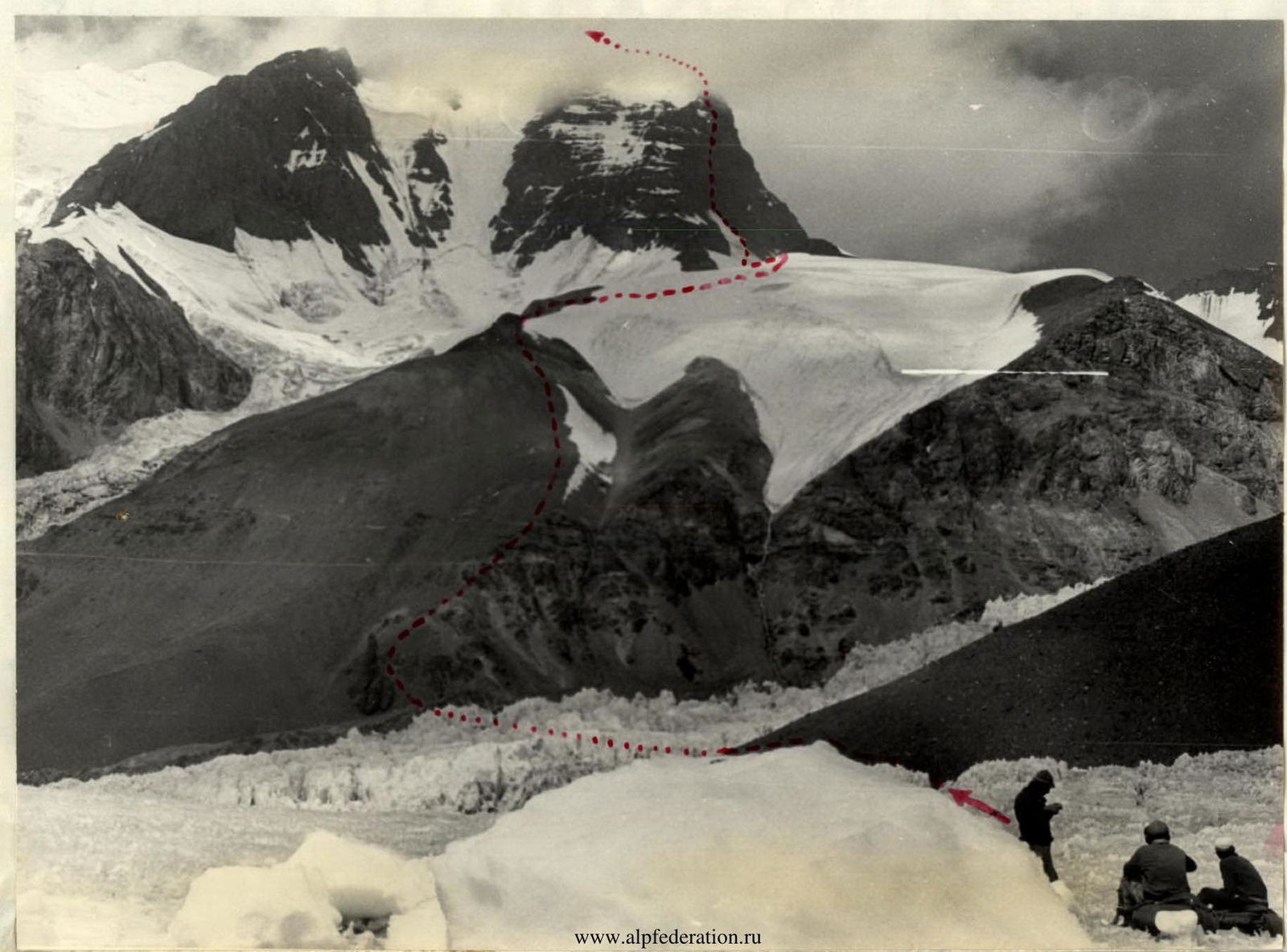
Peak E. Korzhenevsky (7105 m) massif.
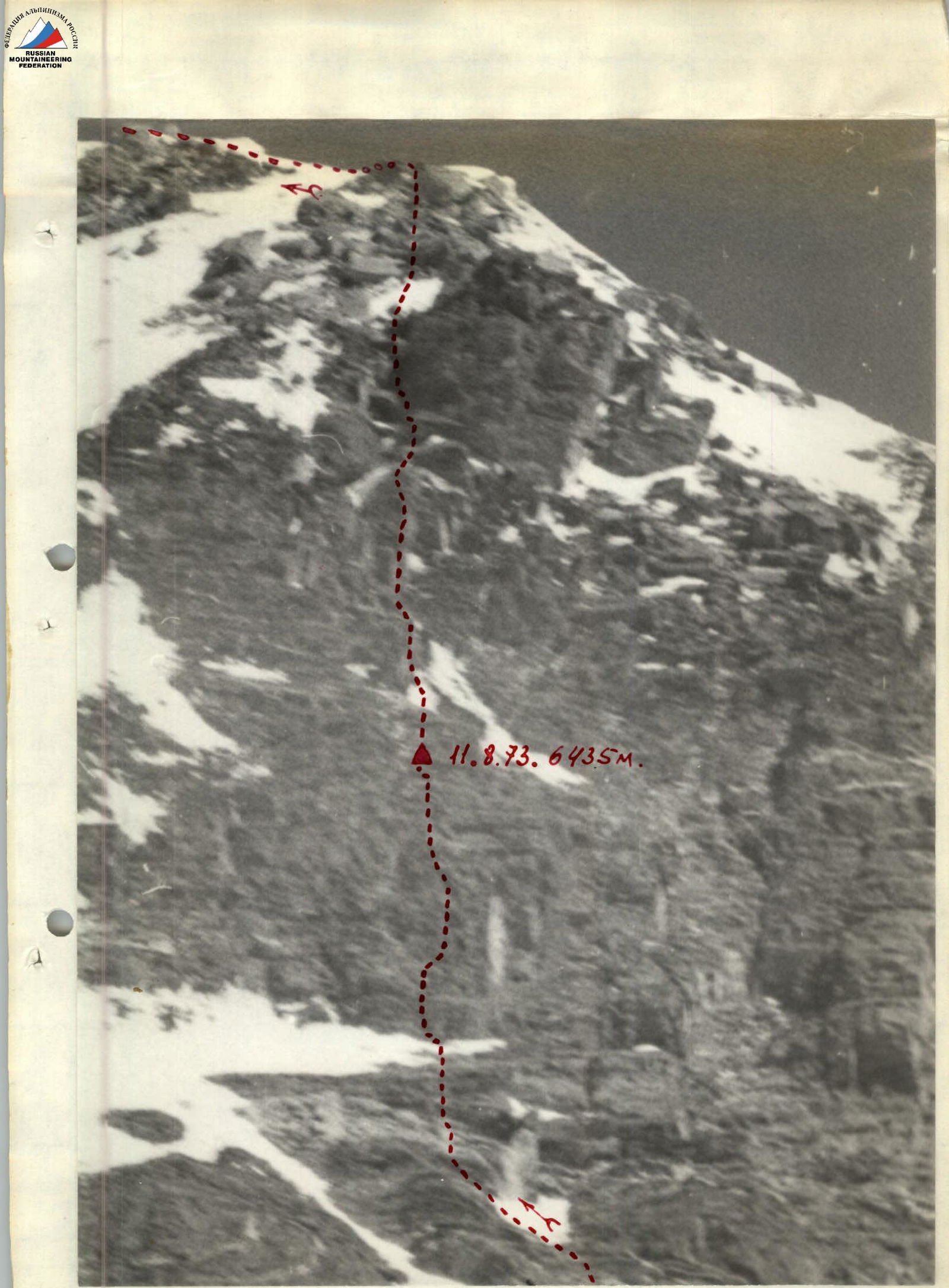
August 11, 1973. 6435 m.
Upper part of the triangle.
- Brief geographical description, research, and history of ascents to Peak Evgeny Korzhenevsky.
Peak E. Korzhenevsky (7105 m) is located in the northwestern spur of the Academy of Sciences range, in close proximity to the highest peak in the Soviet Union — Peak Kommunizma. Peak E. Korzhenevsky was discovered and mapped by the renowned Russian explorer of Central Asia's mountain regions, geographer, and glaciologist N. A. Korzhenevsky in 1970.
The main issues of orography in the Peak E. Korzhenevsky mountain node were resolved, along with the mystery of the Garmo node, only in 1938 by the teams of the Tajik Expedition of the USSR Academy of Sciences, in which N. V. Krylenko participated. The powerful glaciation of Peak E. Korzhenevsky belongs to the basins of the Fortambek and Mushketov glaciers.
The first attempts to ascend Peak E. Korzhenevsky date back to 1936, with an approach from the Korzhenevsky valley. Due to the remoteness and inaccessibility, the beginning of sporting exploration of the area is associated with the mid-1950s. In 1953, Peak E. Korzhenevsky was conquered via the western ridge by an expedition led by A. S. Uvarov under the auspices of the All-Union Central Council of Trade Unions (VCSPS). This ascent was considered one of the best achievements of Soviet mountaineering.
In the 1960s, several interesting and competitive routes were laid to Peak Korzhenevsky from the south, southwest, and southeast from the Fortambek valley. Successful expeditions were conducted by the "Trud" Sports Society in 1961 and the "Burevestnik" Sports Society in 1966. The "Spartak" Sports Society team, led by P. Budanov, ascended to the saddle under Peak Akhmad Doniš and first traversed the ridge's peaks — Peak Chetyrekh and Peak Korzhenevsky — descending into the Fortambek valley. Finally, after several failed attempts, an expedition from Donetsk first laid a route from the Mushketov valley along the counterfort in 1968. In 1969, a team from the Dnipropetrovsk Regional Physical Education Committee, led by A. M. Zaydler, from the Mushketov glacier, laid a new route to Peak 6200 and first traversed the entire massif from northwest to southeast, a feat considered as interesting as it was difficult.
However, until recently, routes on Peak E. Korzhenevsky via the most complex southern and southeastern rock faces (walls), which extend over 1500 m, had not been traversed.
Brief geographical description and ascent conditions in the given area.
In its northern part, the meridional ridge of the Northwestern Pamir — the Academy of Sciences range — bifurcates, giving off a powerful branch to the west, which ends at Peak E. Korzhenevsky. The bifurcation node is the massif of Peak Voroshilov, representing a more than 3-kilometer uplift in the form of a ridge, with heights ranging from 6560 to 6606 m. The massif is flanked by two powerful glaciers (Ayu-Džilga and Moskvina) and separates two large valleys: Ayu-Džilga and Fortambek.
a) Relief features: The rocks composing the Peak E. Korzhenevsky massif are very friable, producing a vast amount of talus and moraines. Nonetheless, the slopes of the entire massif, which drop away to the south, southeast, and east in rock faces, are 1.5–2 thousand meters long. A characteristic feature of the area is the powerful glaciation, abundance of hanging glaciers on steep slopes, and cornices hanging from the ridges. Additionally, a considerable number of rock spires or wall-like rock outcrops on the snow-ice ridge of the Korzhenevsky massif are noteworthy.
b) Weather conditions: Located on the west of the Academy of Sciences range, which acts as a natural climatic barrier in the Pamir, the area around Peak E. Korzhenevsky is one of the most humid regions of the Pamir.
The area is dominated by constant westerly winds, which sometimes reach significant strength. The high elevation results in low temperatures even in sunny weather. Therefore, on the massif's ridge, sections of wind-compacted firn and ice often alternate with areas of powdery, loose snow in wind-sheltered locations. Thus, the area around Peak E. Korzhenevsky is characterized by relative instability, with significant precipitation, strong winds, and, given its considerable elevation, low temperatures.
c) Remoteness. The region of the Fortambek, Mushketova, and Ayu-Džilga valleys is one of the most inaccessible in the Pamir. There are no bases or nomadic settlements nearby; the nearest inhabited point is the village of Altyn-Mazar, which is a long and hazardous journey away.
However, the use of helicopters as a means of transportation and the presence of a reliable radio station significantly bring the base camp closer to populated areas. Practically, all expeditions to this region are now delivered by helicopters.
d) Exploration of the Peak E. Korzhenevsky area. The peaks of the massif have been most thoroughly explored from the side of the Fortambek valley; from here, 5 routes have been laid to Peak E. Korzhenevsky and one each to Peak 6200 (from the Korzhenevsky glacier) and Peak Chetyrekh (6380 m) via the western ridge. Sporting exploration from the Mushketov valley is much weaker, with only one route having been laid: to Peak E. Korzhenevsky along the counterfort; and from the Ayu-Džilga valley, also only one route has been traversed, with an ascent along the eastern ridge to Peak Chetyrekh and then to Peak E. Korzhenevsky.
Preparation of the group and reconnaissance.
Preparation of the participants for the planned ascent to Peak E. Korzhenevsky began long before departure to the mountains. Throughout the autumn and winter of 1972–1973, training was conducted three times a week at the TGU sports complex, as well as at the rock climbing site in the Tsavkisi valley. Training included cross-country running to develop endurance, a set of exercises with weights to develop arm and torso strength, swimming, sports games like football and basketball, trampoline exercises, and improvement of advanced rock climbing techniques. The overall training plan and standards were approved by the Georgian Alpine Club. From February 20 to March 10, 1973, expedition participants were on training camps in Bakuriani. All participants showed good results in alpine skiing (many achieved the II sports category standards). Starting from March 1973, regular acclimatization hikes were conducted in the mountain regions of Georgia. Expedition members ascended several peaks: Chaukhi, Mkinvarcveri (5043 m). The final stage of preparation for the ascent to Peak E. Korzhenevsky was a training camp in Terskol from April 25 to May 15, 1973, with ascents to both peaks of Elbrus. The expedition members knew each other well from years of joint ascents to Caucasian, Pamir, and Tian Shan peaks. Particularly valuable was the experience of joint ascents to peaks such as Peak Vazha Pshavela (Tian Shan) in 1961, Peak Kommunizma in 1972, Peak E. Korzhenevsky in 1972, and the traverse of the Darvaz range, etc. Before departing to the mountains, all available materials on the Peak E. Korzhenevsky area were thoroughly studied.
The Georgian Alpine Club expedition arrived in Dzhirgital on July 17, 1973. On July 20, all expedition members gathered at the base camp located on the left-bank moraine of the Fortambek glacier (Suloev meadow). The base camp's elevation was 3900 m.
The initial plan of the expedition assumed a traverse of Peak "6700" — Peak Kommunizma — Peak Moskva. The ascent to Peak "6700" was planned via the northwestern counterfort. However, due to the extremely hazardous snow and ice conditions on the route, the reconnaissance group (Miriianashvili, Dangadze, Kharazadze, Abashidze) deemed it impractical to proceed with the route until August 15. Consequently, a telegram was sent to the USSR Mountaineering Federation requesting approval to substitute the objective with an ascent to Peak E. Korzhenevsky via the southeastern face. A similar telegram was also sent to the regional authorized representative, Zaydler. On July 26, a response was received: "Approved replacement of objective with ascent to Peak Korzhenevsky via southeastern face — Borovikov, Garf."
An application for the ascent to Peak E. Korzhenevsky via the southeastern face had also been submitted in 1972. In July 1972, our group twice approached the face (once during the ascent to Peak Chetyrekh), conducted a survey, and thoroughly examined the feasibility of ascending from the southeastern side. This was also necessary to clarify the traverse route: Peak Kommunizma — Peak Korzhenevsky, which we had also applied for in 1972. However, due to certain reasons, in 1972 we had to abandon the implementation of the routes applied for primacy and settle for ascents to Peaks Kommunizma and E. Korzhenevsky via the usual paths.
Thus, the route to Peak E. Korzhenevsky via the southeastern face was well known to our group.
On July 23, the assault and observation groups of the expedition, after a one-day transition, relocated to a meadow beyond the left-bank moraine of the Walter glacier. The camp's elevation was 4100 m. On July 29, a group consisting of D. D. Dangadze (leader), Sh. M. Miriianashvili (coach and expedition head), O. L. Kharazadze, G. E. Abashidze, G. D. Akhvlediani, T. Sh. Lukaшвили, S. M. Barliani, M. T. Chichinadze, Sh. N. Gabisiiani, A. M. Gavasheli, L. N. Glonti, and D. Tarkhnishvili, set out to the upper reaches of the glacier to transport supplies and equipment to the vicinity of the southeastern face of Peak E. Korzhenevsky, for a final clarification of the ascent route. It was planned to combine the first sortie with an acclimatization ascent. Peak Chetyrekh (6380 m) was chosen as the acclimatization ascent objective. The ascent to Chetyrekh was accomplished in one day on July 25, with a bivouac at an altitude of 5500 meters.
On July 26, the group reached the base of the southeastern face of Peak E. Korzhenevsky (at the base of the rock triangle formed by the eastern and southern rock counterforts of the eastern subpeak of Peak E. Korzhenevsky) and established an assault camp at an altitude of 5500 m. On July 27 and 28, a final reconnaissance of the route was conducted. Due to the objective danger of rockfall, it was decided to start the route in the left part of the rock triangle, with a subsequent shift to the right and upward, in the direction of the triangle's apex. On July 29, the group returned to the base camp on the Fortambek glacier. The acclimatization ascent demonstrated that the participants were in excellent sports form. Since the expedition plan included a traverse of Peak Kommunizma — Peak Moskva, a second sortie was undertaken from July 31 to August 3 to Pamirovoe, Firnovoe plateau (along the "Burevestnik" ridge) and an ascent to Peak Kuibyshev. As a result of the second sortie, supplies and equipment were transported to the plateau and to the saddle of Peak Kuibyshev. On August 4, the expedition's coaching council finally determined the composition of the assault group: D. P. Dangadze (leader), Sh. M. Miriianashvili (coach), O. L. Kharazadze, G. E. Abashidze, G. D. Akhvlediani, S. M. Barliani, T. Sh. Lukaшвили, A. M. Gavasheli, and Sh. N. Gabisiiani — a total of 9 individuals.
The observation group consisted of 4 individuals: L. N. Glonti (leader), D. I. Tarkhnishvili, G. I. Tarkhnishvili, and M. Sh. Asrotsiani. During the passage of the southeastern face, the observation group was stationed in the upper reaches of the Walter glacier at an altitude of 5500 meters, in close proximity to the face. Communication with the observation group, as well as with the second base camp of the expedition on the meadow of the left-bank moraine of the Walter glacier, was maintained via radio: at 9:00 AM and PM (emergency communication at 12:00 and 17:00 daily), and as needed — via flares.
Organizational and tactical plans.
Given the group's size (about nine people) and the significant technical complexity of the route (the southeastern face of Peak E. Korzhenevsky, in its entirety up to the ridge of the eastern subpeak, presents a rock bastion with a slope of 85–90°), it was decided to organize three trios capable of autonomously solving all tasks arising before them (especially regarding the organization of bivouacs on the face, where setting up tents was entirely ruled out) and maintaining close interaction among themselves. To ensure safety and facilitate a swift descent down the face in case of a forced return, it was planned to leave a hook every 30 meters for organizing a rappel descent, as well as to establish fixed ropes on the most challenging sections. It was also necessary to revisit the issue of high-altitude equipment, as overcoming such a technically complex rock face required the entire arsenal of technical means.
Upper part of section 5.
Considering the significant height, the issue of minimizing high-altitude equipment also became paramount. To reduce the weight of backpacks, the group planned: a) To use lightweight equipment made from strong and light materials (calendered nylon, nylon), as well as metals and alloys. b) Food supplies were packed with high-calorie and concentrated products, calculated at 450 grams per person per day.
The teams were formed as follows:
- Dangadze — Miriianashvili — Abashidze.
- Kharazadze — Gavasheli — Akhvlediani.
- Barliani — Lukaшвили — Gabisiiani.
The departure to the route from the second base camp was scheduled for August 6.
Provision of the assault group with equipment.
| № | Equipment Name | Unit | Quantity | Weight per unit (kg) | Total Weight (kg) |
|---|---|---|---|---|---|
| 1 | 2 | 3 | 4 | 5 | 6 |
| a/Group and Special Equipment | |||||
| 1. | Main ropes 8 mm, 45 m | end | 2 | 1.8 | 3.6 |
| 2. | Main rope 8 mm (80 m) | end | 1 | 3.2 | 3.2 |
| 3. | Safety carabiners | pieces | 30 | ||
| 4. | Profiled, titanium hooks, various | -" | 50 | ||
| 5. | Petal, titanium hooks | -" | 15 | ||
| 6. | Channels, titanium, various | -" | 20 | ||
| 7. | Drilled, expansion hooks | -" | 15 | ||
| 8. | Standard ice hooks | -" | 6 | ||
| 9. | Screw-in, titanium ice hooks | -" | 4 |
COMPOSITION OF THE ASSAULT GROUP OF ALPINISTS GEORGIAN ALPINE CLUB
| № | Surname, First Name, Patronymic | Party Affiliation | Year of Birth | Category | Main Profession | Number of Ascents Category 5 | Duties in Group | Sports Engaged In | Nationality | Home Address |
|---|---|---|---|---|---|---|---|---|---|---|
| 1 | 2 | 3 | 4 | 5 | 6 | 7 | 8 | 9 | 10 | 11 |
| 1. | Miriianashvili Shota Miriianovich | Non-Party | 1936 | Master of Sports | Physicist, Department Head | 18 | Coach | Skiing | Georgian | Tbilisi, Vazha-Pshavela, 34, apt. 26. |
| 2. | Dangadze Dmitry Davidovich | -"- | 1933 | Master of Sports | Lecturer | 18 | Captain | -"- | -"- | Tbilisi, Kote-Meskhi, 34. |
| 3. | Kharazadze Otar Longinozovich | CPSU | 1931 | Master of Sports | Physicist, Department Head | 16 | Participant | -"- | -"- | Tbilisi, Bazaletskaya, 9, III floor, apt. 5 |
| 4. | Abashidze George Irakliievich | Non-Party | 1934 | Master of Sports | Philologist, Senior Researcher | 10 | -"- | -"- | -"- | Tbilisi, Shromskaya, 20 |
| 5. | Akhvlediani George Davidovich | Komsomol | 1950 | Master of Sports | Lecturer | 8 | -"- | -"- | -"- | Tbilisi, Lenin, 37, Alpine Club |
| 6. | Barliani Sergey Magedonovich | Non-Party | 1943 | Candidate for Master of Sports | Student | 8 | -"- | -"- | -"- | Mestia, GSSR |
| 7. | Lukaшвили Tariel Shalvovich | Non-Party | 1942 | Candidate for Master of Sports | Head of Rescue Service, Georgian SSR | 14 | -"- | -"- | -"- | Tbilisi, Nikoladze, 8 |
| 8. | Gavasheli Alexander Maksimovich | Non-Party | 1937 | Candidate for Master of Sports | Geologist, Senior Engineer | 10 | -"- | -"- | -"- | Tbilisi, Irakli II Square, House 1/1 |
| 9. | Gabisiiani Shakro Nestorovich | Non-Party | 1942 | Candidate for Master of Sports | Worker | 8 | -"- | -"- | -"- | Tbilisi, Lenin, 37, Georgian Alpine Club |
TABLE
Main Characteristics of the Ascent to Peak E. KORZHENEVSKY via the Southeastern Face
Height difference — 1600 m,
including complex sections — 450 m.
| Dates | Sections Passed | Average Slope of Section (°) | Section Height (m) | Description of Sections and Conditions of Passage. By Relief Character | Technical Difficulty | Passage Method | Weather Conditions | TIME. Bivouac Stop Time | Departure Time | Travel Hours | Hooks Driven. Rock | Ice | Drilled | Bivouac Conditions | Daily Ration Weight |
|---|---|---|---|---|---|---|---|---|---|---|---|---|---|---|---|
| 1 | 2 | 3 | 4 | 5 | 6 | 7 | 8 | 9 | 10 | 11 | 12 | 13 | 14 | 15 | 16 |
| August 6, 1973 | At 7 AM, the group departed from the II base camp located on the meadow of the left-bank moraine of the Moskvina glacier (4200 m) and at 18:30 stopped for a bivouac near the southeastern rock faces of Peak E. Korzhenevsky. Bivouac on a rock outcrop (5600 m). | ||||||||||||||
| August 7, 1973 | 1 | 35° | 150 | Snow slope | Firm snow | Simultaneous movement in teams | Clear, windy weather | 8:00 | 1:00 | ||||||
| 2 | 50°–55° | 225 | Broken rocks, some small talus | Medium difficulty | Simultaneous movement, some insurance through ledges | Sun, wind | 1:45 | ||||||||
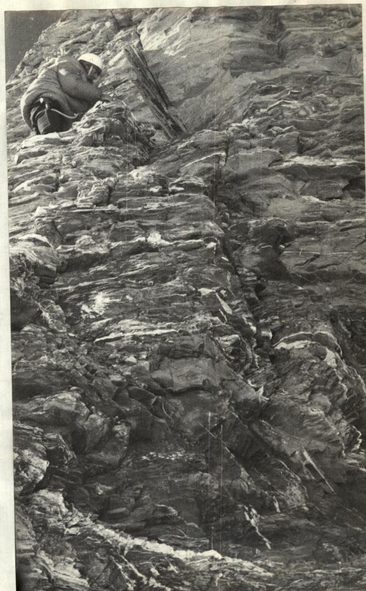
| 3 | 65° | 150 | Broken rock ascent, large blocks, many loose rocks. Some vertical sections of 3–5 m. Rock wall. Exit via inclined terrace, then through narrow crevice upward via vertical chimney and broken slabs to narrow rock shelf. | Above medium difficulty | Insurance through ledges and hooks | Sun, wind | 29:30 | 5 | Bivouac sitting on rock shelf | 450 g | |||||
| 4 | 75° | 70 | Difficult rocks, some additional handholds | Hook insurance. Very difficult climbing | Sun, wind | 18:30 | 4:15 | 12 | |||||||
| August 8, 1973 | Total: | 9:30 | 17 | ||||||||||||
| 5 | 80° | 80 | Rock wall of large-block structure. Crevices, shelves, cornices. In two places — negative sections of 5 m | Very difficult climbing with ladder use. Rucksacks pulled up. | Hook insurance. Rucksacks pulled up using block-and-tackle | Sunny weather. Calm, despite high altitude — warm. | 8:00 | 6:40 | 21 | 2 | Bivouac sitting (separate) on inclined rock shelf | 450 g | |||
| 6 | 90° | 20 | Vertical slab with longitudinal cracks. Exit to narrow rock shelf is negative | Very difficult climbing | Hook insurance | Sunny, warm | 18:45 | 2:50 | 7 | ||||||
| Total: | 9:30 | 28 | 2 | ||||||||||||
| August 9, 1973 | 7 | 90° | 70 | Vertical rock bastion. Key section is inclined crevice leading to the base of a cornice, which is bypassed on the left via overhanging and broken rocks. Broken rock ascent. Passage using artificial supports | Very difficult and dangerous section | Hook insurance, rucksacks pulled up | Sunny weather | 8:20 | 6:20 | 18 | Bivouac sitting on rock shelf | 450 g | |||
| 8 | 85° | 20 | Vertical rock wall. Middle section is negative. Rock wall is a key section of the entire route | Very difficult climbing. Exceptionally difficult section | Hook insurance | Sunny weather | 19:00 | 3:00 | 7 | ||||||
| Total: | 9:20 | 25 | |||||||||||||
| August 10, 1973 | 9 | 85° | 40 | Vertical rock wall. Middle section is negative | Very difficult climbing | Hook insurance | Sunny weather | 8:00 | 4:30 | 13 | Bivouac sitting on rock shelf | 450 g | |||
| 10 | 90° | 30 | Rock wall, key section of the entire route | Exceptionally difficult section | Hook insurance | Sunny weather | 20:00 | 6:20 | 17 | 1 | |||||
| Total: | 10:50 | 30 | 1 | ||||||||||||
| August 11, 1973 | 11 | 80° | 35 | Broken rock ascent. Many loose rocks. Broken rocks, tiled structure | Difficult section, especially in the middle | Hook insurance | Sunny weather | 8:15 | 2:25 | 6 | Bivouac on rock terrace /semi-reclining/ | 450 g | |||
| 12 | 75° | 80 | Rock ascent, vertical chimney 12 m in the middle. Broken rock-snow slope. Rock-snow ridge. Several rock spires encountered | Difficult and dangerous climbing | Hook insurance | Sunny weather | 17:30 | 5:40 | 13 | ||||||
| Total: | 8:05 | 19 | |||||||||||||
| August 12, 1973 | 13 | 80° | 40 | Rock ascent, vertical chimney 12 m in the middle | Difficult climbing | Hook insurance | Sunny weather | 8:30 | 3:10 | 6 | 1 | 450 g | |||
| 14 | 60° | 30 | Broken rock-snow slope | Medium difficulty | Insurance through ledges, ice axes, hooks | Sunny weather | 1:30 | 2 | On snow ridge at 6500 m | ||||||
| 15 | 50° | 160 | Rock-snow ridge. Several rock spires encountered | Medium difficulty | Insurance through ledges and ice axes | Sunny weather, wind | 17:00 | 3:20 | 2 | ||||||
| Total: | 8:00 | 8 | 2 | ||||||||||||
| August 13, 1973 | 16 | 50° | 90 | Snow-rock ridge | Medium difficulty | Insurance through ice axes and ledges | Sunny weather, wind | 8:00 | 1:05 | 2 | On southern ridge at 6500 m | 450 g | |||
| 17 | 30° | 450 | Snow-rock ridge. Some rock spires. Reached the summit at 17:50 | Below medium difficulty | Simultaneous movement | Sun, wind | 8:00 | 2 | |||||||
| 18 | 40° | 605 | Descent from the summit along the southern snow-ice ridge | Below medium difficulty | Simultaneous movement in teams | Sun, wind | 20:00 | 1:20 | |||||||
| Total: | 10:25 | 3 |
On August 14, 1973, the group, continuing their descent, reached the base camp at an altitude of 4100 m by 17:00.
Thus, during the passage of the southeastern face of Peak E. Korzhenevsky (excluding the day of approach from the base camp to the base of the face and the day of descent from the summit along the southern snow-ice ridge) over 7 travel days (travel hours 64:20), the following were driven:
- rock hooks — 126.
- ice hooks — 5.
- drilled hooks — 5.
TEAM CAPTAIN DANGADZE D.
TEAM COACH MIRIANASHVILI SH.