
25
Peak Kovshovykh (Central), 5800 m
via the central ridge of the western wall, combined, category 5A difficulty
Description of the First Ascent
made on August 8-10, 1968 by a group of climbers participating in the high-altitude alpinist gathering of the Chelyabinsk Regional Council of the "Zenit" Sports Society, led by Galchenko V.B.
The description was compiled by:
- Galchenko V.B.
- Konev V.F.
- Silchenko S.L.
with the participation of the coach-consultant, Master of Sports of the USSR, Levin M.S.
Chelyabinsk Regional Alpine Federation
1969
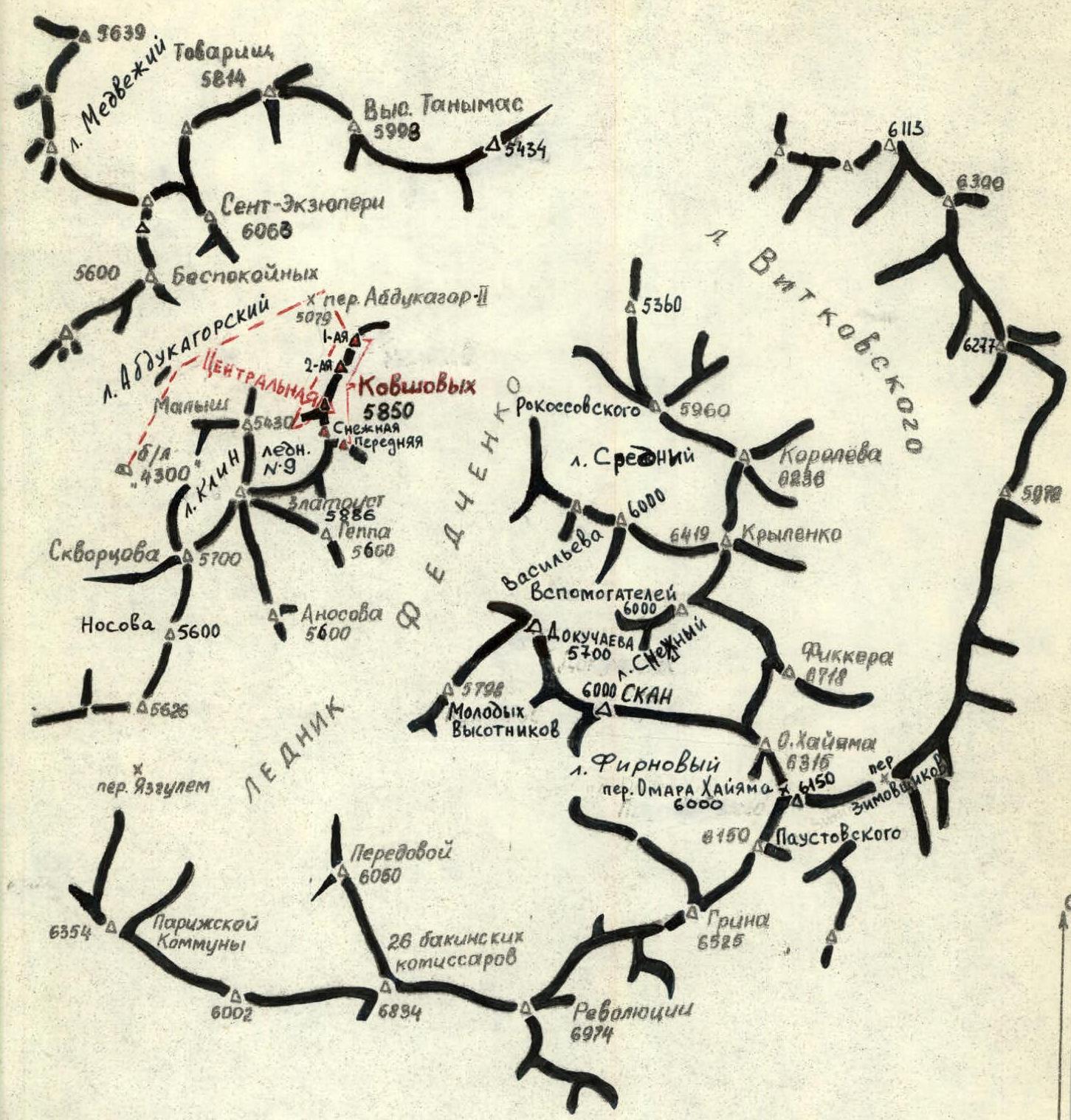
Central Pamir
Ridges of the Fedchenko Glacier headwaters. The route of ascent to Kovshovykh-Central is shown with a dotted line.
Glacier
△△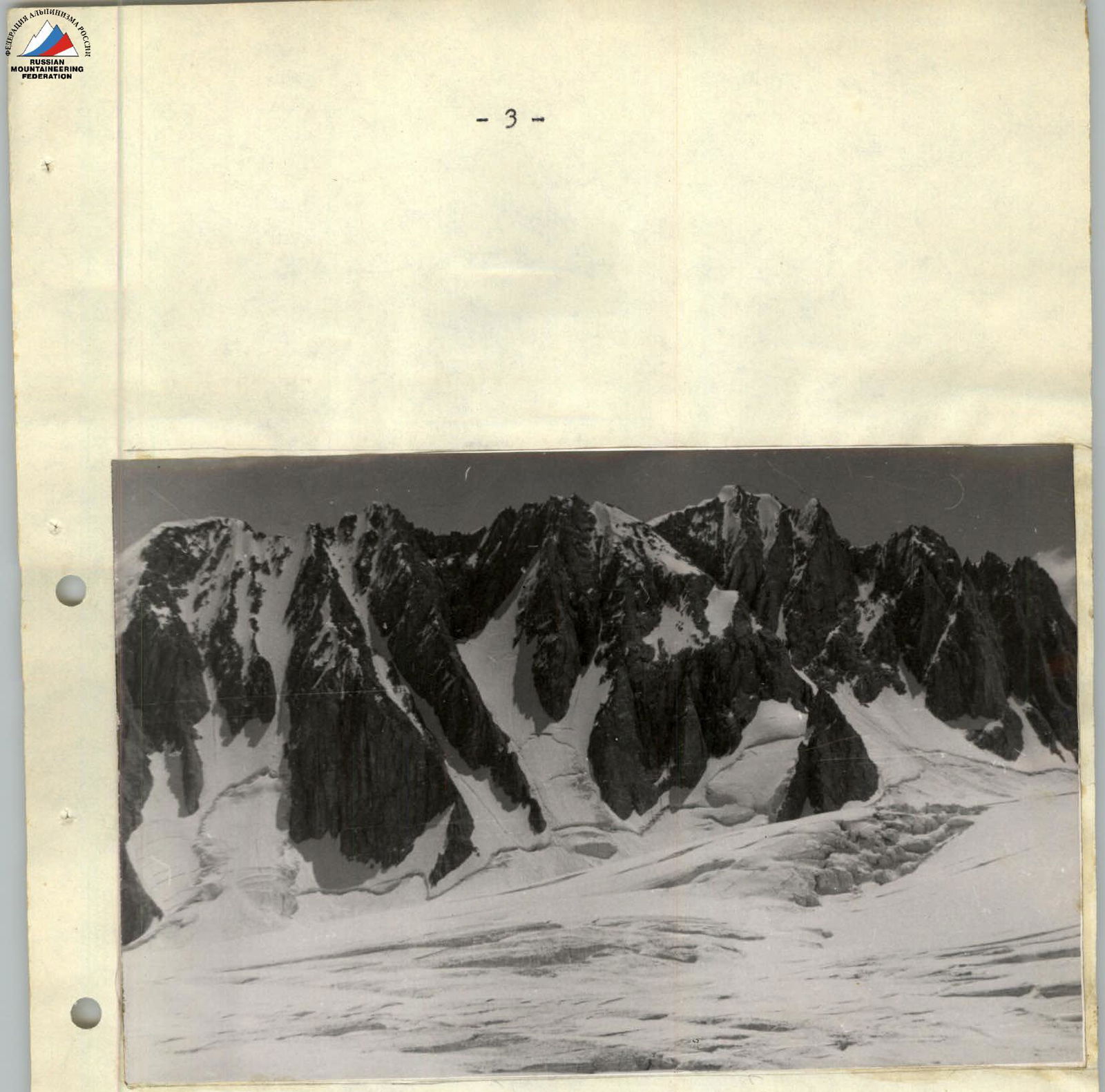
Photo #1. View from the Abdukagor-2 pass to the Peak Kovshovykh massif (the front peak is obscured by Snezhnaya)
Introduction
The problem of connecting the Vanch River valley with the Fedchenko Glacier was solved in 1928 by the Soviet-German expedition — as noted by one of the founders of domestic mountaineering, Nikolai Vasilievich Krylenko: "…the pass we crossed turned out to be Kashal-Ayak! The gorge to the left, the same one from which the second river flowed, turned out to be no less famous and mysterious Abdu-Kagor pass, about which some Pamir researchers wrote as completely inaccessible."
In the same year, 1928, this "mysterious and inaccessible" pass was opened from the side of the Fedchenko Glacier by I.G. Dorofeev and named "Abdukagor-2", and the expedition of the High-Altitude Research Commission of the Geographical Society of the USSR (expedition leader — Lukomsky S.M.) first passed through the Abdukagor-2 pass from the Vanch valley to the Fedchenko Glacier in 1955. This established the shortest route to the upper reaches of the Fedchenko Glacier for many tourist groups and mountaineering expeditions.
In their article "To the Sources of the Fedchenko Glacier," authors E.A. Kazakova and S.M. Lukomsky, describing their first impressions after reaching the Abdukagor-2 pass, mention that they did not immediately manage to orient themselves: "…It turns out that the upper reaches of the Fedchenko Glacier are hidden from us by a rocky cape, which merges with the ridge of the opposite bank of the glacier."
This "rocky cape" (see photo #1) is an 800-meter barrier separating Glacier #9 from the Fedchenko Glacier. Stretching in a meridional direction for 5-6 km, the barrier appears inaccessible due to the steepness of both its western and eastern walls. When examined from nearby peaks, 5 independent peaks can be distinguished in it, differing very slightly in height:
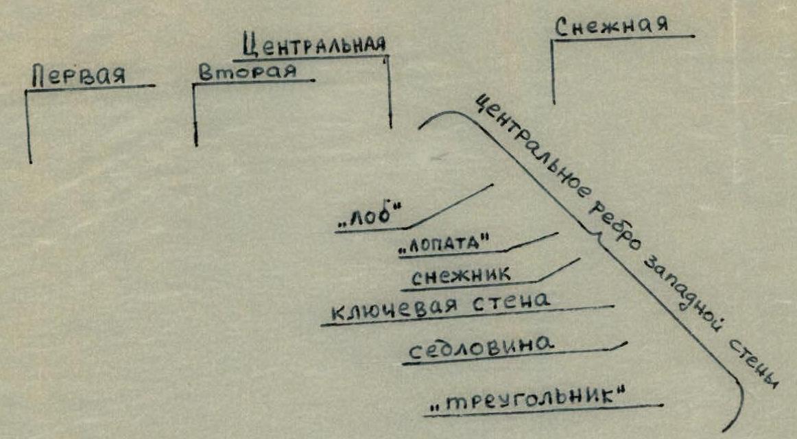
- First
- Second
- Central
- Snezhnaya
These four are located in the main ridge, to which the fifth peak, Perednaya, is adjacent from the east, directly to Snezhnaya.
The elevation mark of 5800 m found on the map attached to the aforementioned article by Kazakova and Lukomsky can be attributed to either Snezhnaya or Perednaya peaks of the massif (the other peaks are slightly lower than these).
The first known attempts to ascend the peaks of the "5800" massif were made in 1967 by climbers from Zlatoust — participants in the jubilee high-altitude expedition of the Chelyabinsk Regional Sports Council. The ascent to the First peak from the northwest via a counterfort was made by V. Shanin and A. Zakharov. A few days later, V. Shanin and A. Sannikov attempted to ascend Snezhnaya via its southern ridge, which is replete with numerous rocky ascents.
The climbers retreated at the point where the rocky ridge adjoined the 100-meter summit dome, on the ice of which snowboards were hanging.
On July 29, 1968, participants in the high-altitude alpinist gathering of the Chelyabinsk Regional Council of the "Zenit" Sports Society, Galchenko V.B. and Likhinin A.I., were tasked by the senior coach of the gathering, Master of Sports of the USSR, Levin M.S., to scout out an uncharted route — the central ridge of the western wall of Peak "5800" (see photo #2). As a result of thorough reconnaissance, the route for the described first ascent was developed.
The ascent was made from the "4300" base camp, which the alpinist gathering set up on a platform between the left (orographically) lateral moraines of the Abdukagor-2 glacier. Protected from winds on all sides by these moraines, this location is the most convenient for organizing the highest possible base camp. A geological party that had worked on this platform until recently had благоуisted it to a sufficient extent; in addition, geologists, and later numerous tourist and mountaineering groups, had laid a trail here suitable for a caravan of donkeys.
The ascent was made in ideal weather conditions and after a two-week acclimatization period and training ascents to peaks 5600 m, 5798 m, and 6150 m via routes of 2-3 categories of difficulty.
All participants in the ascent have classifications in competitive rock climbing (two have the 1st sports classification).
Group composition and alpinist qualification:
- Galchenko V.B. (leader) – 2nd sports classification (ascents: 4B – Komosomola via the southern wall, Ficker, Peak Omar Khayyam).
- Konev V.F. – 2nd sports classification (ascents: 5B – Vazha Pshavela, 4B – Ficker, Peak Korolev).
- Silchenko S.L. – 2nd sports classification (ascents: 5B – Karbyshev, 5A – Brigantina, 4B – Ficker, Peak Korolev).
Proposals for Naming
The first ascenders to the 1st peak of the massif — Zlatoust metallurgists V. Shanin and A. Zakharov, participants in the Jubilee high-altitude expedition of the Chelyabinsk Regional Sports Council dedicated to the 50th anniversary of Soviet power, proposed naming the massif "Peak Kovshovykh" in honor of their fellow countrymen Vitaly Kovshov and his niece Natasha Kovshova.
The first was a professional revolutionary — a red commander who established Soviet power in the Southern Urals, he died in the Civil War and was buried in the Kremlin wall on Red Square.
Natasha Kovshova — Hero of the Soviet Union, a sniper, heroically died defending Moscow from German-Fascist invaders.
The participants in the described first ascent join the wishes of the climbers from Zlatoust and request that the unnamed peak "5800" in the area of the Abdukagor-2 pass (Central Pamir) be named Peak Kovshovykh.
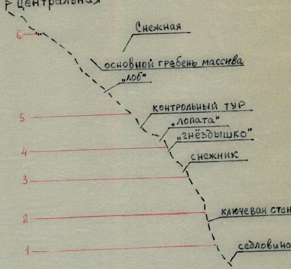
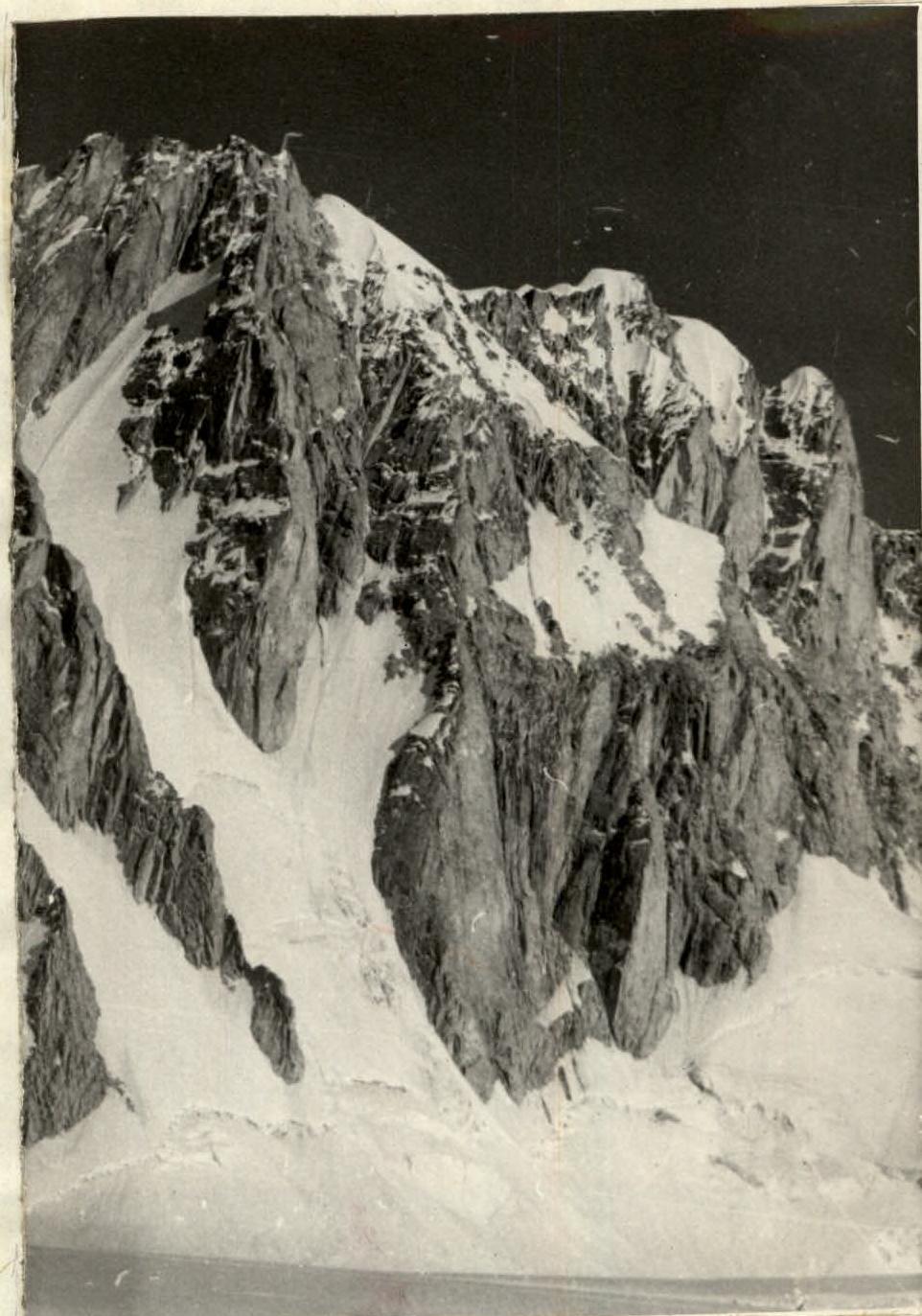
Photo #2
View from the north to the central ridge of the western wall ("triangle" is out of frame). The route of the described first ascent is shown with a dotted line on tracing paper. View from the south, see photo #3.
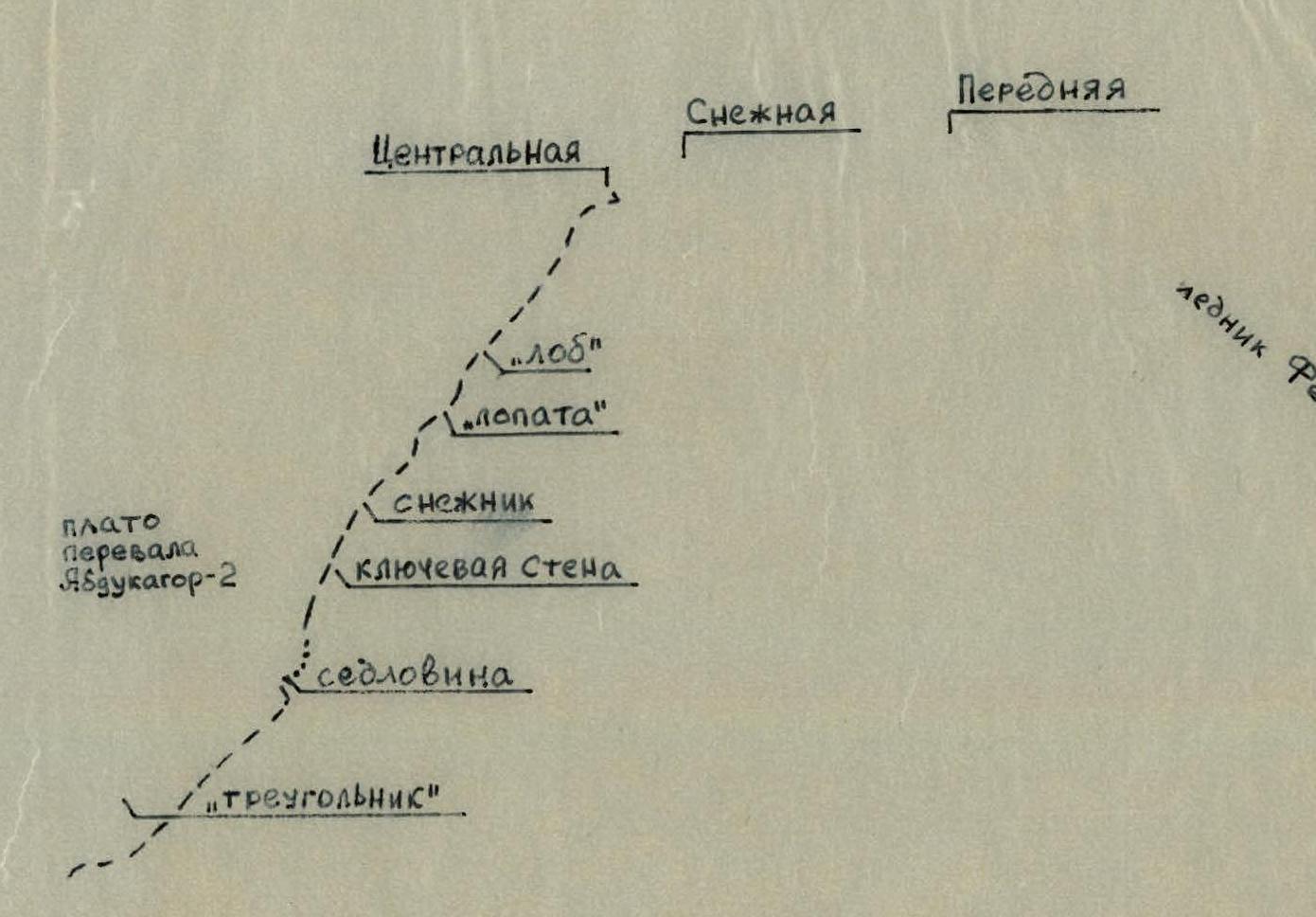
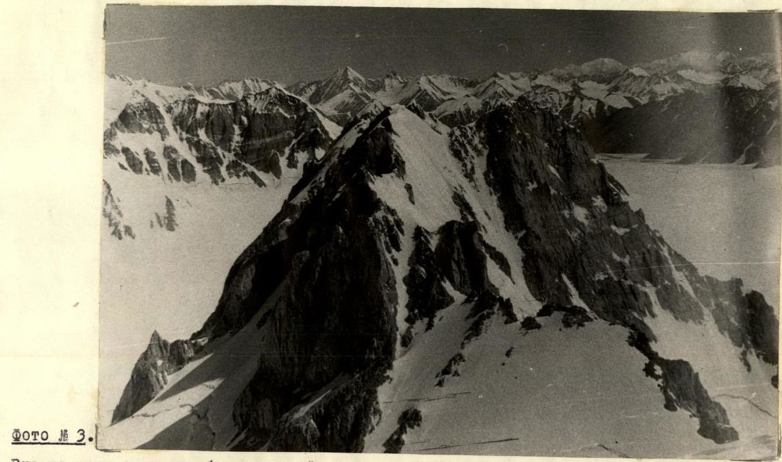
Photo #3
View of the central ridge of the western wall from the south. The group's path is shown with a dotted line on tracing paper.
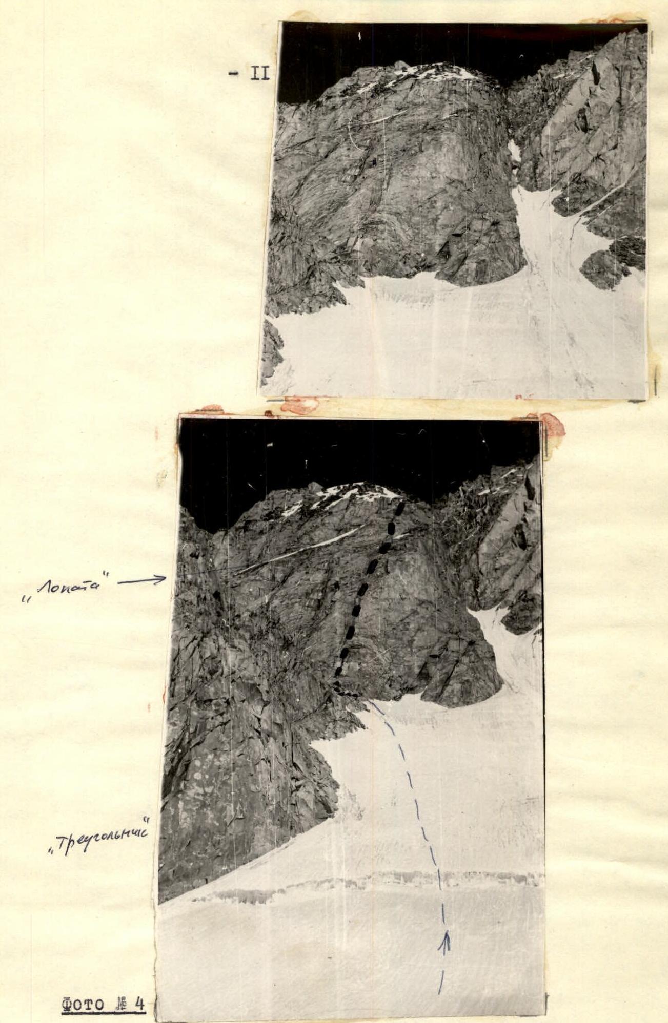
Photo #4
View from below upwards to the central ridge of the western wall. The group's path is shown with a dotted line on tracing paper.
Technical Description
From the base camp through the frequently described icefall to the Abdukagor-2 pass.
As one approaches it, the characteristic "barrier" of Peak Kovshovykh rises ahead to the right. The path of the described first ascent — the central ridge of the western wall — is clearly visible.
From the pass, circumventing the breaks of Glacier #9 plateau along the western wall to the lower exit of the rocks of its central ridge "triangle" — here, at 5000 m, in the snow of the plateau, the group spent the night, 5-6 hours from the "4300" base camp.
The ascent from the plateau to the snow-ice saddle under the key wall of the ridge should begin about 50 m south of the lower rocks of the ridge, not directly next to them due to rockfall danger. After passing the нависание of the bergschrund (difficult!), along a 45° ice slope on crampons, the ascent from the bergschrund is 180 m, followed by traversing a gully (flow ice) to the saddle (14 ice screws; 2 hours 30 minutes of work from the designated overnight spot).
Climb up the ice of the saddle (screws) to under the key wall. The landmark for the start of the route up the wall is three steps one above the other in its central part, behind which a long, narrow crevice that is not visible to the end ascends. See photo #2 for the section breakdown.
Section R1–R2 (10 pitons): Ascent up the steps is 7 m (live rocks!).
At the start of the crevice, drive in pitons and from them climb vertically up the crevice, where after 15 m (very difficult! — almost no holds outside the crevice, climbing with a wedging motion):
- use a ledge on the wall for support;
- a piton can be driven into the deepening crevice;
- place a wedge as high as possible (additional point of support, without which it's impossible to pass the subsequent 2-meter overhang).
Immediately beyond the overhang, pitons can be well-placed. From here upwards along a 160°-direction, in the center of which the crevice continues, 15-17 m of high-complexity rocks to a one-person ledge (the only place on the entire 1st rope allowing rest).
2nd rope: continuing along the 35 m direction of rocks of the same difficulty to where the crevice transitions into a chimney 0.5 m wide, obliquely leading out to a wet black couloir (do not enter the couloir — heavy rockfall).
Section R2–R3 (12 pitons): from the junction of the chimney and couloir, a sloping (double slope) ledge leads upwards to the right, the exit to which is very difficult (an additional point of support — an ice piton driven into the rocks — was used). Along the ledge to the internal angle formed by a rocky outcrop, which, overhanging, blocks the ledge — here up to 4 people can be accommodated before passing the "plug", the key section of the 3rd rope. By throwing the rope over the outcrop, reliable belay can be ensured for the first climber along the negative internal angle (3 m) and then along the chimney with the "plug". After the "plug":
- transition to difficult rocks like "ram's foreheads";
- 15-20 m of climbing on an overhang;
- return to the black wet couloir, but now at its very top (mulda-collection area).
On large sloping ledges under the right (by direction) wall of the mulda, a group of 6-8 people can be accommodated.
4th rope: along the right wall of the mulda for 20 m to its end, and then 10-12 m along the wall directly to a sloping crevice, traversed left, leading out to a ledge. From here, rocks becoming more gentle (up to 55°), after another one and a half to two ropes of giant steps, lead out to a snowfield.
Section R3–R4 (4 pitons): passing along the snowfield to the right for 40 m to the ridge, then along the snow of the ridge under section R3–R4 (4 pitons): under the 25-30-meter negative wall made of sheer slabs and unstable blocks. Climb up it cautiously for 12-15 m, only then will a nearly horizontal, deeply indented joint between huge slabs — the "Gnez-dyshko" ledge (it's safe to set up a tent here!) — become visible on the left.
After overcoming the 5-meter wall closing "Gnez-dyshko", we arrive (section R4–R5 – 3 pitons) on the edge of a snow "spade", along which we exit onto its ridge, and then under a rocky ascent (here is a control cairn, see photo #5).
Immediately beyond the rocky ascent wall — 18 meters of extremely difficult climbing over a large depth (rare, very small, sloping, and at the top, ice-covered holds!) — begins section R5–R6 (8 ice, 2 rock pitons) — a 240-meter snow-ice "forehead", steeply dropping into a couloir to the right.
On crampons, from one rocky islet (see photo #6) to another, often encountering flow ice, we pass the "forehead", and then, bypassing an ice lakelet, climb comparatively easily onto the main ridge 100 m south of the Central peak.
Through several "gendarmeries" and a huge snow undulation (descent 45-50 m along a snow cornice overhanging to the east!), we approach the base of the peak — a monolithic 40-meter tower, up the diagonal cracks of which we ascend to the highest point (5800 m).
No signs of other groups' presence were found on the summit or on the route.
The most expedient descent is by the ascent route without alternatives.
Recommendations for the Route and Categorization Proposals
- Helmets are mandatory for everyone; crampons for all; Vibram soles (or galoshes) for the first climber on complex rock sections.
Also necessary are:
- main ropes not shorter than 40 m;
- 100-meter rappel rope (for перил);
- expendable rappel rope for loops;
- 2 aluminum or titanium wedges;
- ladders.
Recommended tactical scheme:
- First day — very early departure from the "4300" base camp, approach under the "triangle". Processing of the key wall by a pair (hanging 100, or better 120 m of перил), descent of the pair to a bivouac under the "triangle".
- Second day — from the bivouac to "Gnez-dyshko" — setting up a tent here, departure on a light ascent to the summit and descent to "Gnez-dyshko" for an overnight stay.
- Third day — descent along the ridge and then to the "4300" base camp.
Optimal group size: 4 people.
- The group did not have ascents equal in technical saturation to the described one.
The key rock sections of the described route are comparable to the Yalta трассы of competitions; ice-snow work is not below the level of routes of the 4th category of difficulty (Caucasian, Tian Shan).
Overall, in the opinion of the compilers of this description, the route corresponds to the 5A category of difficulty, and for this reason, the group petitions the Alpine Federation of the USSR to include it in the All-Union Classification Table — (Central) "Kovshovykh Peak 5800 m, comb. 5A via the central ridge of the western wall".