
4.1.27
4.1.28
Pamir, Center.
2nd Eastern summit of Kovshovykh massif
Ascent via the northwest wall followed by a traverse through the 1st Eastern summit. (First ascent)
Expedition by Odessa regional council of DSO "Avangard". Report No. 332 dated 10/6-71. 5A first ascent team leader V. Lifshits
Geo-graphical characteristics of Kovshovykh peaks massif
Pamir is the highest mountain junction where powerful Central Asian ranges converge: Hindukush in the south, Karakorum in the southeast, little-studied Kunlun in the east, and Tian Shan in the north. It covers an area of about 60,000 km², elevated by mountain-building processes to an average height of almost 4 km above sea level.
The Pamir highland is the highest of all mountain uplifts in the Soviet Union and has the largest area of modern glaciation, about 8041 km².
The main center of glaciation in the Pamir highland is the Fedchenko Glacier, the greatest valley glacier on our planet.
Stretching 71.7 km from south to north, and 75.2 km with a large firn basin, the Fedchenko Glacier is compressed on all sides: to the west by the Akademiya Nauk range, to the east by a whole system of mountain ranges and spurs.
The Akademiya Nauk range is oriented meridionally; its average height over 31 km (up to the Kashal-Ayak pass) is 6301 m, and it is here that the highest peak in the Soviet Union, Peak Kommunizma, rises to 7495 m. To the south, up to the Yavgelem pass, the average height of the range is also enormous, 5757 m. Over its approximately 75 km length, the Akademiya Nauk range has only three clearly defined passes:
- Kashal-Ayak
- Abdukagor II
- Yavgelem
To the south, immediately beyond the Abdukagor II pass, lies the Kovshovykh peaks massif, extending about 10.5 km. The average height of the Kovshovykh peaks massif is 5583 m, with the highest point being 5850 m - the Main summit. Steep western and northwest slopes of the massif rise above the glacier surface, forming walls that offer excellent climbing opportunities.
Tectonically, this area of the Akademiya Nauk range belongs to the Alpine geosynclinal region. Upper Paleozoic, Triassic, and Lower Jurassic rocks, as well as Upper Jurassic and Lower Cretaceous limestones, play a major role in the geological structure of the peaks.
The Kovshovykh peaks massif is composed of crystalline schists with numerous intrusive and vein bodies - fine-grained granite and basalt.
From the summits of the Kovshovykh peaks massif, a breathtaking panorama unfolds:
- on one side, the giants and colossi of the Pamir highland,
- on the other, the emerald-green canyon of the Pyandzh River,
- far to the southwest, endless chains of snowy giants of the Hindukush and Karakorum.
Sports characteristics of Kovshovykh peaks massif
The geographical location of the Kovshovykh peaks massif in the upper reaches of the Fedchenko Glacier, the remoteness of this area from transportation routes, the harsh climbing conditions, and the absolute and relative height of the peaks make it possible to undertake climbs in this area only under expedition conditions.
The nearest neighbors of the Kovshovykh peaks massif are the giants of the Yavgelem range and the Vysokaya Stena range:
- Peaks Parizhskoy Kommuny - 6354 m
- Peak Revolyutsii - 6974 m
- Peak 26 Baku Commissars - 6834 m
- Vysokaya Stena - 6300 m
- Korolyova - 6236 m
- Peak Krylenko - 6419 m
- Peak Fickera - 6718 m
- Peak A.Grina - 6526 m
All expeditions working in this area typically choose one or several of these peaks as their climbing objective, and consider peaks up to 6000 m as training grounds, conquering them via the simplest routes.
The Kovshovykh peaks massif has five summits:
- 1st Eastern - 5730 m;
- 2nd Eastern - 5831 m;
- Central - 5550 m;
- Main - 5850 m;
- 2nd Western - 5610 m.
Despite:
- The fairly high average height of the Kovshovykh peaks massif;
- The sheer walls, buttresses supporting the summits, which suggest classic climbing routes;
- The relatively long routes;
- The solid rocks composing the massif;
- The attractive beauty of the massif, the Kovshovykh peaks massif remains largely unexplored by climbers.
Numerous climbing expeditions to this area have only managed to conquer the Central summit via a 5A category route. The first ascent of the Central summit was made by a group of climbers from the Chelyabinsk expedition from the Abdukagor pass in 1954, and in the same year, they outlined a route to the 1st Eastern summit via the north ridge.
Currently, the exploration of the area has entered a qualitatively new stage - conquering peaks (above 5500 to 6000 m) via logical, beautiful routes of the highest category of complexity. (See photo 1)
Selection of the ascent route
Photographs, route descriptions, and recommendations from participants in the preceding expedition to this area had already drawn the attention of our team's coaching council to the northwest and southwest walls of the Kovshovykh peaks massif in 1968.
When determining the main objectives of the 1970 expedition, one of the first tasks was to conquer the Kovshovykh peaks via a route of the highest category of complexity.
From the first exit to the Abdukagor pass, team members began studying and observing the Kovshovykh peaks massif. The 2nd Eastern summit (5831 m) was chosen as the object of ascent due to:
- Potential safety of the route (absence of rockfall and avalanche-prone areas, snow cornices hanging over the route)
- The eastern part of the massif is the highest and least explored.
- Logical and beautiful route.
Two steep counterforts lead to the 2nd Eastern summit from the Abdukagor II pass, each representing a beautiful and logical route to the summit.
After careful study of the routes, the left counterfort was chosen as potentially the safest (the no less interesting right counterfort leads directly to the pre-summit ridge with a huge hanging corniche, bypassing which is impossible with further traverse of the ridge leading to the 1st Eastern summit; further progression to the right towards the Central summit is of less sporting interest since the route to it has already been laid).
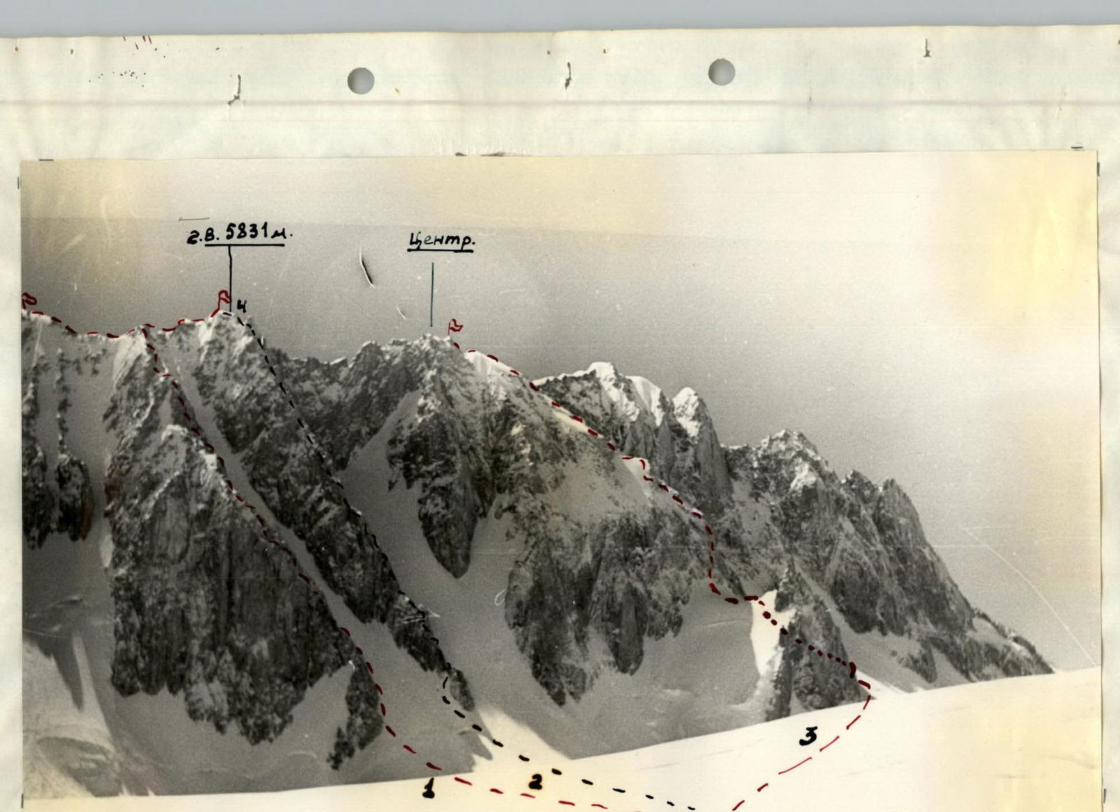
2nd Eastern 5831 m. Center.
Photo 2. Routes. Selected ascent options. Route 1 was taken. Under study and reconnaissance. On the Central summit, classified. Summit 4, dome, dangerous hanging corniche.
The first ascent of the 2nd Eastern summit of the Kovshovykh peaks massif was of interest to the team for several reasons:
- Long wall combined route;
- Logical and straightforward route up the wall, representing three belts of rock formations of block structure made of fine-grained granite, connecting the base to the summit via the shortest path.
- The passage of the planned route would significantly contribute to the exploration of the area. (Photo 2)
Composition of the sports group
For participation in the 1970 All-Ukrainian and Central Council of DSO "Avangard" climbing competitions in the technically complex ascents and traverses class, a team of climbers from the Odessa regional council of DSO "Avangard" was entered.
The main group consisted of masters of sports, candidates for master of sports, and ranked climbers: Lifshits V.Ya., Tibeykin L.A., Vaisberg E.M., Simonenko V.K., Volkats B.M., Sviridenko V.S., Kolomeytseva V.V., Nelupov V.A., Cheskidov N.N., Mozeson A.I., Staritsky P.I., Korolev A.M., Stavnitser A.M., Perekrestov V.G.
The final composition of the group for the ascent was determined based on the ascent tactics. Since the planned route combined elements of technical complexity over a prolonged period, as well as a traverse along the ridge, the optimal number of participants was chosen to be 6 people. Although the task of finalizing the team composition was somewhat simplified by the fact that all team members knew each other well and had completed several ascents of the highest category of complexity together, it was not an easy task. After final approval by the coaching council, the team was presented in the following composition:
- Lifshits V.Ya. - team leader
- Simonenko V.K. - participant
- Korolev A.M. - participant
- Kolomeytseva V.V. - participant
- Staritsky P.I. - participant
- Perekrestov V.G. - participant
Detailed information about the group participants can be found in Table No. 1.
II. Description of the route passage
July 29, 1970
At 7:30, a group of 4 people sets out to scout the approaches to the wall and process the lower section of the wall. A route to the wall is found and marked in the web of crevasses. The absolute height of the base of the wall, as measured by an altimeter, is 4900 m. One pair studies the wall and observes it:
- Lighting conditions;
- Rockfall danger;
- Avalanche danger;
- Potential bivouac sites.
The other pair begins ascending to a rocky island connected by a narrow rocky ridge to the base of the counterfort. The slope leading to the rocky island is snow-ice, with a steepness of 55–60°, the upper layer of snow is heavily compacted by falling avalanches and wind. The first rope is passed - with difficulty, steps are cut into the snow. Very hard snow. Further movement is on crampons, about 90 steps are cut. A perlon rope is anchored, and two rock anchors are driven. Three ropes are anchored. The nature of the rocks is clarified: strong basalts and fine-grained granite with good handholds. The rocks are covered in ice. Potential bivouac sites are identified. Processing is completed, and the group returns to the base camp at 19:30.
July 30, 1970
A day of final preparations and route clarifications. The entire route is carefully reviewed one last time using a 12x binocular (during further movement, no more than 20–30 m of the wall will be visible) with detailed analysis of individual sections.
The steep wall is visible from the base camp en face. Finally, after all route clarifications and bivouac locations are determined, all proposals are collected and consolidated into a single plan, which becomes the law.
At 20:00, the entire camp is in "lights out" mode.
July 31, 1970
Ascent at 6:00. Very cold. The height is taking its toll. The thermometer shows −22°C. After a quick breakfast, the group sets out at 6:45. At 7:50, they approach the start of the ascent. A 10-minute rest, and at 8:00, they begin the ascent via the anchored ropes.
Section R0–R1. Using the anchored ropes, they begin ascending the steep snow-ice slope. The previously cut steps and hacked ice footholds are very helpful. The average slope steepness is 55–60°. During processing, 2 rock and 2 ice anchors were driven. At 9:10, they reach the rocks of the large rocky island.
Section R1–R2. The rocky island appears as a giant boulder with sheer walls; they begin moving along the edge of the rocks and ice. When moving along the island's walls, they use them to drive rock anchors. A total of 8 rock anchors were driven. The group has only 2 pairs of crampons. The slope steepness is 55°, so they almost continuously cut steps; in some places, they drive ice anchors. A total of 2 ice anchors were driven. After three ropes of path, skirting the rocky island to the right, they approach a spot where the height of the island's rocky walls decreases to 40 meters.
Section R2–R3. A rocky wall with a steepness of 60–70°, extending 38–40 meters, leads to the ridge of the counterfort. The wall is divided into three sections by two snow ledges, which are climbed with careful anchor protection. Very cold. Despite all the insulation, their feet are freezing. A total of 6 rock and 1 ice anchor were driven.
Section R3–R4. At the point of exit to the counterfort, they establish the first control cairn. From the control cairn, they ascend directly up a 40-meter wall. In the center of the wall, there is a 9-meter overhanging section with a нависом 0.5–0.6 m. Very difficult spot!!! For artificial support, they drive an ice anchor. In the upper part of the wall, the rocks are covered in ice, making movement extremely difficult. A total of 8 rock anchors were driven on the wall. The average steepness is 70–85°.
Section R4–R5. Further movement is directly up the poorly defined ridge, composed of giant stones covered in snow and ice, forming a series of sheer walls. The nature of the rocks allows them to use individual stones reliably frozen into the ice for protection. Despite the relatively gentle slope (55–60°), movement is slow due to the abundance of ice and snow. The section is 80 m long. A total of 9 rock anchors were driven. At 11:45, they are illuminated by the sun.
Section R5–R6. Further movement follows the counterfort towards a black rocky wall. They move as if along a giant rocky staircase with step heights of 10–15 meters. A total of 6 giant steps. The "staircase" is 160 meters long. A total of 18 rock anchors were driven. Careful anchor protection. The average steepness is 60°.
Section R6–R7. The rocky "staircase" leads to a narrow ridge abutting a black wall. The ridge is 80 meters long. The average steepness is 50–55°. The rocks are of moderate difficulty. Protection is via anchors and, in some places, rock outcrops.
At 18:30, the last pair reaches the base of the black wall. The second pair begins processing the path further. The first pair clears a site for bivouacking. After 1.5 hours of work by four people, two platforms are hacked into the ice for tents. At 20:30, "lights out".
August 1, 1970
Section R7–R8. Ascent at 6:30. Very cold. Their route is in the shade until 12:00, and is only illuminated by the sun in the middle of the day. Temperature −25°C. They return 5 meters back and begin ascending the black wall. Yesterday, two ropes were anchored. The pair took 2.0 hours to process 80 m of path. According to them, the average steepness is 70°. Despite anchored ropes, climbing is very difficult. The anchored two ladders with 6 rungs each are not much help. The backpack pulls down like a curse. The structure of the rocks is the same - titanic rocky blocks made of fine-grained granite, covered in ice and, where there are minimal handholds, - topped with snow. They continuously chip away at the ice. Over three hours of tedious climbing along the perlon ropes, they reach the end of the processed section. A total of 12 rock and 1 ice anchor were driven.
Section R8–R9. An easy traverse 20 m to the right and straight up a 30-meter rocky wall with a steepness of 85°. The beginning of the wall is a very difficult spot, overcome with the help of artificial supports (2 anchors driven) and ladders. In the upper part, the wall is covered in ice, which they mostly had to chip away. A total of 6 rock anchors were driven.
Section R9–R10. Along a very narrow rocky ridge with a steepness of 75° and a length of 80 m, they move directly up towards the main ridge of the Kovshovykh peaks massif. The path along the ridge is blocked by two rocky walls 7 and 10 m high, which they overcome using ladders and artificial handholds. A total of 10 rock and 1 ice anchor were driven. Careful anchor protection.
Section R10–R11. Gradually, the rocky ridge turns into a snow-ice ridge with inclusions of rocky outcrops. Careful anchor protection, driving anchors into rocky outcrops. The section's steepness is 60°, and its length is 120 m. A total of 4 rock and 2 ice anchors were driven. At 17:00, movement along the counterfort's ridge leads them to the main ridge of the Kovshovykh peaks massif. Clear weather. The sun illuminates them, as if rejoicing with them that the main part of the route is completed.
Section R11–R12. Movement along the snow-ice ridge towards the 2nd Eastern summit of the Kovshovykh peak. The snow is unstable and heterogeneous; the ridge is like a layered pie made of snow and ice. To the left hang giant cornices. Each step is carefully considered and planned. They pass 80 m. Protection is via ice axe and anchors driven into rocks. At 18:00, they approach a rocky outcrop on the ridge. Four people start arranging platforms for tents; the third pair goes to process the route further. At 20:00, tents are set up; at 22:00, "lights out".
August 2, 1970
Ascent at 6:00. Cold, −20°C. Their tents are bathed in sunlight. They quickly get dressed and have tea. Emerging from the tents, they freeze: before them lies the entire Pamir, with not a cloud in the sky. Camera shutters click incessantly. Within 10 minutes, 6 film rolls are shot. Beautiful. At 7:00, without backpacks, they begin moving towards the 2nd Eastern summit.
Section R12–R13. They quickly move along the perlon ropes anchored yesterday towards a жандарма with a giant corniche. The ridge is steep, up to 80°; the perlon ropes are very helpful. Protection is via anchors driven into rocky outcrops.
Section R13–R14. Along a steep snow-ice ridge with large cornices, with careful protection, they move towards the summit. Very dangerous spot. Protection is via ice axe. The snow holds poorly; it's loose, like powder; layers of ice in the snow are porous and cannot hold either an anchor or an ice axe. They are well-rested, without backpacks, which helps them greatly. Not reaching the summit by two ropes, they excavate a rocky outcrop and drive 4 rock anchors into it. Having passed 160 m, at 8:30, they stand on the summit of the 2nd Eastern summit of the Kovshovykh peaks massif. Leaving a note and building a cairn out of several stones, surrounded by snow, they quickly descend to the bivouac site. They dismantle the bivouac and, at 10:00, begin moving towards the 1st Eastern summit.
Section R14–R15. Descent sitting on a rope down a sheer ice-covered wall onto a narrow sloping ledge 0.5 × 0.6 m, to which a ice ridge leads. Difficult spot!
Section R15–R16. Movement along a very sharp snow-ice ridge with a steepness of 50°, directly along the line, slightly below the line of corniche detachment, towards a rocky outcrop. The snow is loose, powdery. Very dangerous. To the right, huge cornices hang. A total of 1 rock and 3 ice anchors were driven. Difficult and potentially dangerous spot.
Section R16–R17. Movement along the snow-ice ridge with alternating steps: cutting steps on icy sections. Very careful, with large cornices to the right. Protection is via ice axe, ice and rock anchors driven into rocky outcrops. The section is 160 m long.
Section R17–R18. Further path lies along a snowy ridge with a steepness of 60°; the snow is dense, holding well. Protection is via ice axe. After 80 m, they stand on the summit of a snowy dome, from where the ridge sharply drops towards the Fedchenko Glacier. They descend 20 m to the rocks. They are on the summit of the 1st Eastern summit of the Kovshovykh peaks massif. They build a cairn and, at 15:00, begin descending along a rocky counterfort towards the base camp. (Photo 3)
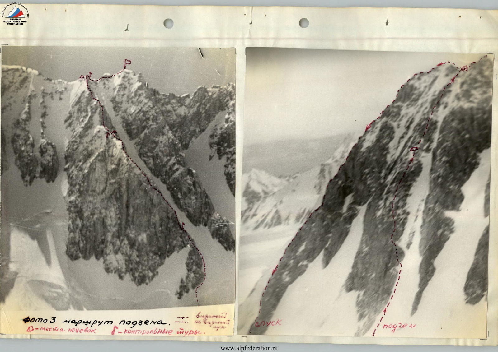

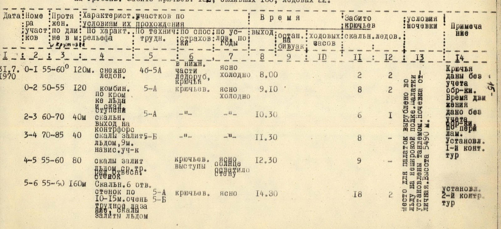
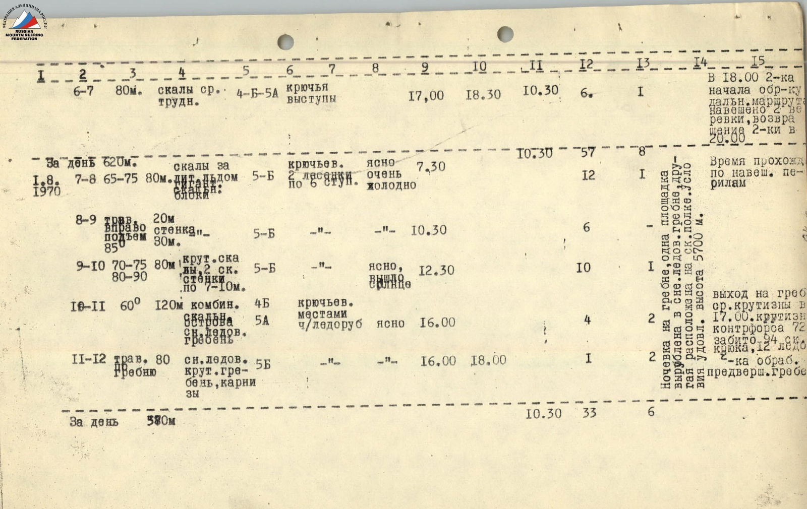
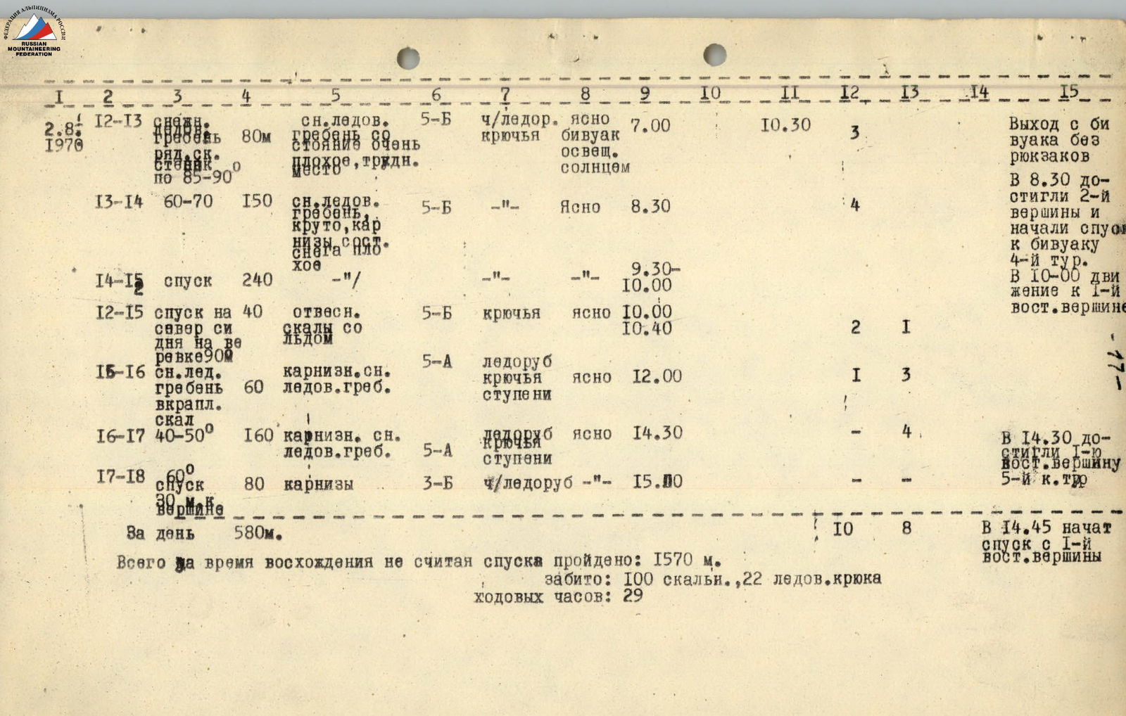 Photo 3. Ascent route.
- Bivouac locations
- Control cairns.
Descent
Descent began at 15:00, following advice and consultations from members of the Chelyabinsk expedition; the descent route follows a ridge, approximately 4B category of complexity. However, only after 7 hours and 30 minutes of clear and coordinated work, applying the entire arsenal of technical means and methods, did they reach the base of the ridge on the glacier at 22:30. During the descent, 9 rappels and 4 sports descents of 40 m were made, and about 30 anchors were left. Upon reaching the snow under the counterfort, they were immediately met by their observers and received warm congratulations and even warmer tea.
Route conclusion:
- The route taken by the team is logical, beautiful, and absolutely safe.
- Considering the technical characteristics of the route, its combined nature, and the absolute height of the summits, the team believes that the route is undoubtedly 5A category of complexity, provided the descent is made via the ascent route. The traverse complicates the route.
Assessment of team members' actions:
Throughout the entire route, each team member clearly knew and diligently performed their duties.
All team members demonstrated themselves to be qualified and physically fit climbers, allowing for frequent rotation of the lead pair without losing pace. Every group member contributed to the passage of this interesting and complex route.
Observation of the assault group and communication with it were carried out by the auxiliary group of the expedition throughout the entire ascent period until the return to the base camp.
Team leader, senior coach P.M.S. V. Ya. Lifshits
Table of main characteristics of the most complex sections of the ascent to the summit
2nd Eastern peak of Kovshovykh via the northwest wall with further traverse to the 1st Eastern summit. Summit height - 5831 m, height difference 931 m. Average steepness of ascent 72.1°, length of most complex sections 470 m.
Data on ascent via counterfort to the ridge:
- Anchors driven: 122
- rock anchors - 100
- ice anchors - 22
| Date | Section | Length (m) | Relief characteristics | Steepness, difficulty | Protection method | Weather conditions | Departure time | Time at bivouac | Working hours | Rock anchors driven | Ice anchors driven | Bivouac conditions | Notes |
|---|---|---|---|---|---|---|---|---|---|---|---|---|---|
| 31.07.1970 | R0–R1 | 120 | snow-ice | 55–60°, 4Б–5А | Ice axe, anchors | Clear, cold | 8:00 | 2 | 2 | Anchors given without processing. Time given without processing. Via perlon ropes. 1st control cairn established. | |||
| R1–R2 | 120 | combined along ice and rocks edge | 50–55°, 5А | Anchor protection | Clear, cold | 9:10 | 8 | 2 | |||||
| R2–R3 | 40 | rocky exit to counterfort | 60–70°, 5А | 10:30 | 6 | 1 | Bivouac site hacked into ice on narrow ledge. Tents set up in tandem. Excellent bivouac conditions. Height 5490 m. | ||||||
| R3–R4 | 40 | rocks covered in ice, 9-meter overhanging section | 70–85°, 5Б | 11:30 | 8 | ||||||||
| R4–R5 | 80 | rocks covered in ice, sheer | 55–60° | Anchor protection, outcrops | Clear, sunlit | 12:30 | 9 | ||||||
| R5–R6 | 160 | rocky "staircase" with 6 sheer walls 10–15 m high, very difficult, covered in ice | 55–60°, 5А | Anchor protection | Clear | 14:30 | 18 | 2 | 2nd control cairn established. | ||||
| R6–R7 | 80 | rocks of moderate difficulty | 4Б–5А | Anchor protection, outcrops | 17:00 | 10 h 30 min | 6 | 1 | At 18:00, pair began processing further route. 2 ropes anchored, return at 20:00. | ||||
| For the day | 620 | Time given for passage via perlon ropes. | |||||||||||
| 01.08.1970 | R7–R8 | 80 | titanic rocky blocks made of fine-grained granite, covered in ice and snow | 65–75°, 5Б | Anchor protection, 2 ladders with 6 rungs | Clear, very cold | 7:30 | 10 h 30 min | 12 | 1 | |||
| R8–R9 | 20 | traverse right, ascent 30 m, 85° | 5Б | 10:30 | 6 | ||||||||
| R9–R10 | 80 | steep rocks, 2 rocky walls 7–10 m | 70–75°, 5Б | Clear, breeze | 12:30 | 10 | 1 | ||||||
| R10–R11 | 120 | combined snow-ice ridge | 60°, 4Б–5А | Anchor protection, ice axe | Clear | 16:00 | 4 | 2 | Exit to ridge at 17:00. Pair processed pre-summit ridge. | ||||
| R11–R12 | 80 | traverse, snow-ice ridge, cornices | 5Б | 16:00 | 18:00 | 1 | 2 | Bivouac on ridge, one platform hacked into snow-ice ridge, another on rocky ledge. Satisfactory conditions. Height 5700 m. | |||||
| For the day | 580 | 33 h | |||||||||||
| 02.08.1970 | R12–R13 | 80 | snow-ice ridge, steep, cornices, poor snow conditions, difficult | 55–60°, 5Б | Ice axe, anchors | Clear, bivouac sunlit | 7:00 | 10 h 30 min | 3 | Exit from bivouac without backpacks. Reached 2nd summit at 8:30 and began descent to bivouac. 4th cairn. Moved to 1st Eastern summit at 10:00. | |||
| R13–R14 | 150 | snow-ice ridge, steep, cornices, poor snow conditions | 60–70°, 5Б | Clear | 8:30 | 4 | |||||||
| R14–R15 | 240 | descent | 9:30–10:00 | ||||||||||
| R14–R15 | 40 | sheer rocks with ice | 5Б | Anchors | Clear | 10:00 | 10:40 | 2 | 1 | ||||
| R15–R16 | 60 | corniche snow-ice ridge, rocky inclusions | 5А | Ice axe, anchors, steps | Clear | 12:00 | 1 | 3 | |||||
| R16–R17 | 160 | corniche snow-ice ridge | 40–50°, 5А | Ice axe, anchors, steps | Clear | 14:30 | 4 | Reached 1st Eastern summit at 14:30. 5A category of complexity. | |||||
| R17–R18 | 80 | cornices | 60°, 3Б | Ice axe | 15:00 | ||||||||
| For the day | 580 | ||||||||||||
| Total for ascent time, not including descent: 1570 m. Anchors driven: 100 rock, 22 ice. Working hours: 29 h. |