- Climbing type: rock climbing
- Climbing area: #2.9 (Eastern Caucasus)
- Peak, its height, and climbing route: Shalbuzdag 4142 m via the southeast wall
- Proposed difficulty category: 2B
- Route description: Height difference 500 m, average steepness 45°, length of sections with I difficulty category — 200 m, II category — 330 m, III category — 190 m, IV category — 20 m.
- Pitons hammered (for belaying): rock: 15 ice: 0 bolt: 0
- Number of walking hours: 8
- Number of nights and their characteristics: no overnight stays
- Surname, name, patronymic of the team leader and participants, their sports qualification:
- Timoshin Mikhail Egorovich: Master of Sports of the USSR
- Pashuk Evgeny Grigorievich: 1st sports category
- Mirzoev Abdulla: 1st sports category
- Leonov Petr Georgievich: 1st sports category
- Kozorezov Evgeny Fedorovich: 1st sports category
- Kudryavtsev Anatoly: 1st sports category
- Team coach: Timoshin Mikhail Egorovich
- Date of departure and return: November 7, 1978
 Climbing area map for Shalbuzdag peak (4142 m) via the southeast wall. 3B category, approximate.
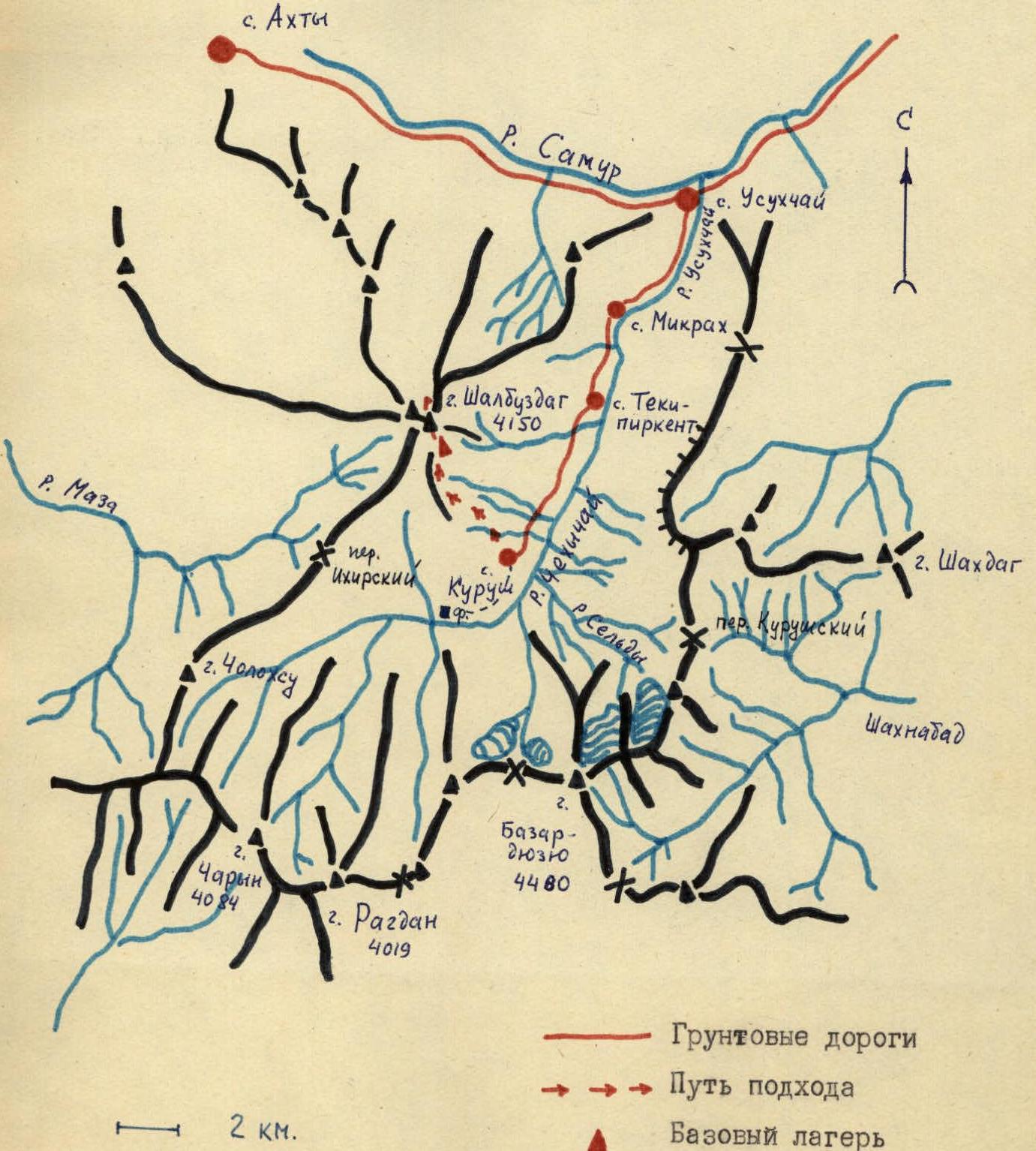
Description of the approach to the route on Shalbuzdag peak via the southeast wall, 3B category, approximate
From Kurush village, Akhtynsky district, DASSR, located on the slope of Shalbuzdag mountain at an altitude of 2500 m, follow the trail along the stream upwards. The trail leads to a gentle grassy slope intersected by numerous gullies. Along the slope, leftwards, upwards towards the clay ridge leading to the steep red scree of the main Shalbuzdag peak. From Kurush village to the ridge, it takes 2.5–3 hours.
Along the ridge, leftwards upwards, past the cirque wall of Shalbuzdag peak, towards the left scree couloir. 100 m before the steep red scree, there's a bivouac site. A stream runs there. From Kurush village, it takes 4–4.5 hours.
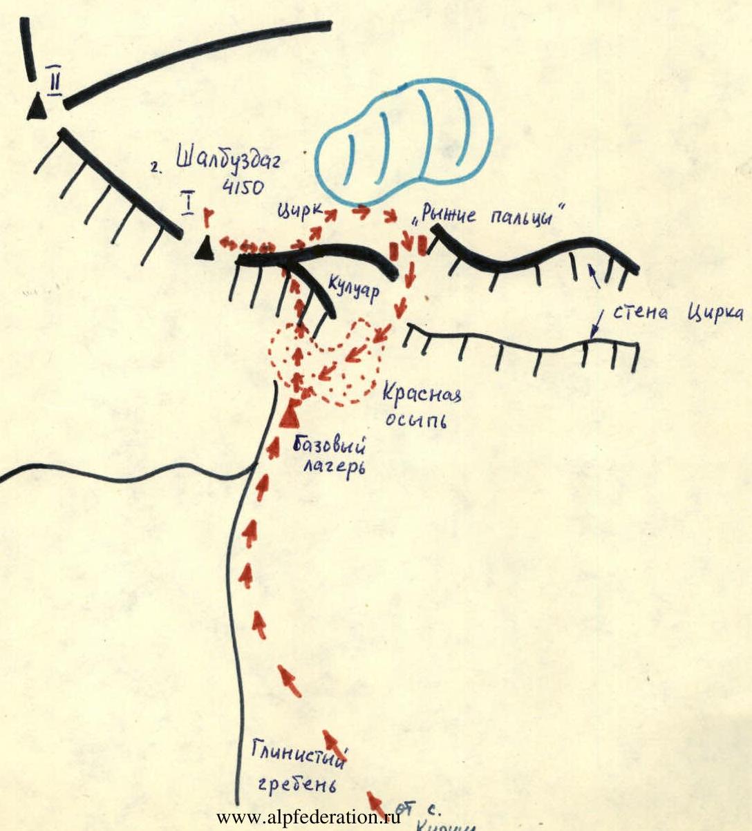
Table of route sections to Shalbuzdag peak (4150 m) via the southeast wall, 3B category, approximate
| № | Average steepness in degrees | Length in m | Relief character | Difficulty | Condition | Weather conditions | Rock pitons | Ice pitons | Bolt pitons |
|---|---|---|---|---|---|---|---|---|---|
| 1 | 30 | 200 | Scree | 1 | Large stones | good. Simultaneously | – | – | |
| 2 | 60 | 25 | Inner corner | III | Monolith | good | 2 | – | |
| 3 | 70 | 5 | Through grotto | IV | Monolith, ice flow | good | 1 | – | |
| 4 | 60 | 35 | Ledge | III | Monolith | good | 2 | – | |
| 5 | 70 | 30 | Inner corner | III–IV | Monolith | good | 3 | – | |
| 6 | 70 | 25 | Wall | III | Monolith | good | 2 | – | |
| 7 | 40 | 80 | Ledge, transition to couloir | II | Broken rocks | good | 1+ledge | – | |
| 8 | 40 | 150 | Broken rocks, scree | II | Large stones | good. Simultaneously | – | – | |
| 9 | 50 | 60 | Ridge | III | Monolith | good | 1+ledge | – | |
| 10 | 20 | 40 | Wall traverse | II | Monolith | good | 1+ledge | – | |
| 11 | 70 | 30 | Wall, transition to scree | III | Monolith | good | 2 | – | ✓ |
| 12 | 50 | 60 | Ridge | II | Broken rocks | good ledges | – | – |
Description of the climbing route to Shalbuzdag peak via the southeast wall, 3B category, approximate
The route begins on the scree of large red stones, going left from the Eastern couloir to the southeast wall of the main peak. Under the wall, there's a ledge. From here, follow the inner corner towards the grotto. The grotto is through. Its walls are covered with ice. Behind it, there's a niche for four people. Further, along a not very pronounced steep ledge to the second niche. This is the first control point. Then, along a weakly expressed inner corner — one rope length of difficult climbing to a ledge for two people. From here, 25 m of similar climbing along the wall to a wide scree ledge. Further, rightwards along the scree couloir to a wide scree. At its beginning, on a rock finger, there's the second control point. The scree leads to broken rocks, along which 20 m to the ridge. Follow the ridge to a very difficult section of the "saw". Bypass it leftwards, traversing the wall, to a 30 m wall leading to the scree, along which you can reach the pre-summit ridge. Further, along broken rocks — to the summit. There's a trigonometric point here. From the bivouac, it takes 8 hours.
Descent:
- Along the ridge to the source of the Eastern couloir.
- From there, leftwards — 30 m of sports descent to a snowy slope and along it to the cirque.
- Further, between two characteristic reddish pillars — into the right scree couloir down to the wide scree under the cirque wall and along it to the bivouac.
Descent takes 2.5–3 hours.
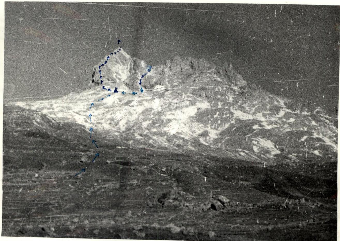
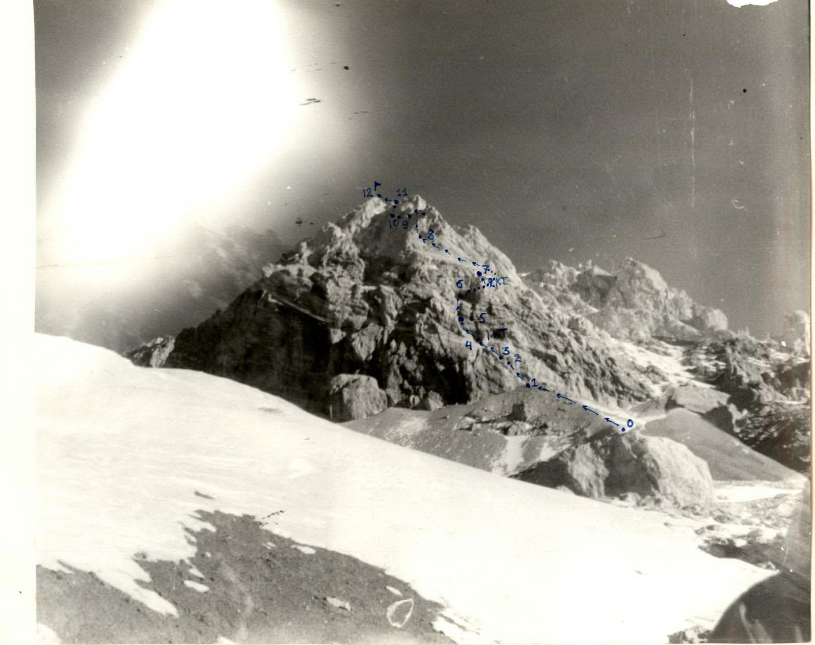
Photo of Shalbuzdag peak from Kurushsky pass.
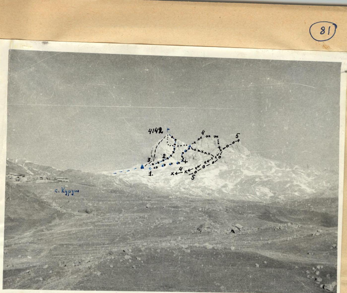
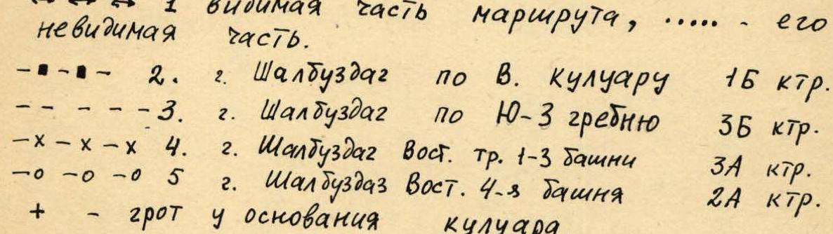
Photo 2. View of Shalbuzdag peak from the Southeast. Shooting point #2 (area scheme). "Industar" lens F = 50 mm. Distance ≈ 7 km. ↔↔↔ 1 — visible part of the route, …… — its invisible part.
-
-
- 2. Shalbuzdag peak via the Eastern couloir, 1B category.
-
-
-
-
- Shalbuzdag peak via the SW ridge, 3B category. -×-×-× 4. Shalbuzdag peak, Eastern traverse 1–3 towers, 3A category. -0-0-0 5. Shalbuzdag peak, Eastern 4th tower, 2A category.
-
-
- — grotto at the base of the couloir.