
- Climbing category - rock
- Climbing area - Eastern Caucasus, Khde (Kistinki) gorge
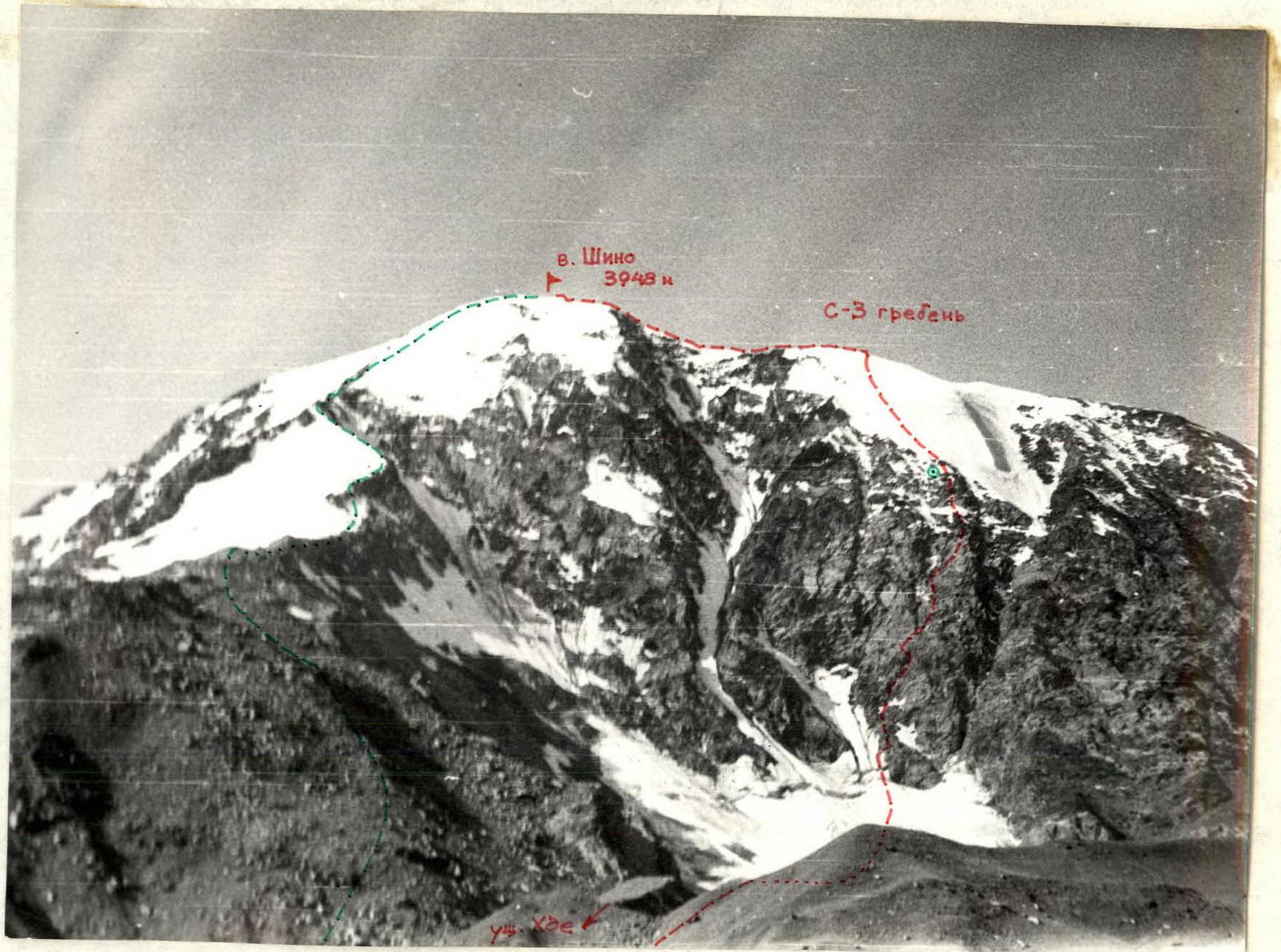
- Peak - Shino, height 3948 m, route - Shino via the center of the North face
- Proposed category of complexity - 4B
- Route characteristics: height difference of the wall - 900 m; average steepness 55°; length in meters of sections:
- 2A - 400 (pre-summit ridge)
- 2B - 140
- 3A - 165
- 3B - 260
- 4A - 195
- 4B - 405
- 5A - 95
- 5B - 45
- Pitons hammered: rock - 42, ice - 22, chocks - 13
- Number of climbing hours - 20
- Number and characteristics of bivouacs: 1, comfortable
- Group composition:
- Javakhishvili Tsotne Davidovich, 1st category, leader
- Serebryakov Mirian Sergeyevich, 1st category
- Sulikashvili Gela Andreyevich, 1st category
- Vashakmadze Ivan Guramovich, 2nd category
- Team coach - ICM Shota Mirianashvili
- Date of departure on the route - July 26, 1985, date of return - July 27, 1985
Shino from Khde (Kistinki) gorge - 2A category of complexity Shino via the center of the North face - proposed category of complexity - 4B
Brief overview of the area
Khde (Kistinki) gorge - a right tributary of the Terek River, 12 km below the village of Kazbegi. The area often hosts mountaineering events, but it is not sufficiently developed. The reason for this may be the poor rock quality (mainly schist). The area has:
- several 2-category routes,
- five 3B category routes,
- one 4B category route.
Shino is the extreme southern massif of the Western ridge. It is the only massif with monolithic rock quality (diabase), especially pronounced from the north. The North face stands out against the background of the southern and eastern slopes of neighboring massifs with its rock quality. Snow-covered ledges and slabs, a steep ice-and-snow ascent in the upper part of the wall give the route a combined character.
The North face of Shino attracted our attention, and at the meetings of the Tbilisi State University mountaineering section in June 1985, we decided to make a first ascent of its central part.
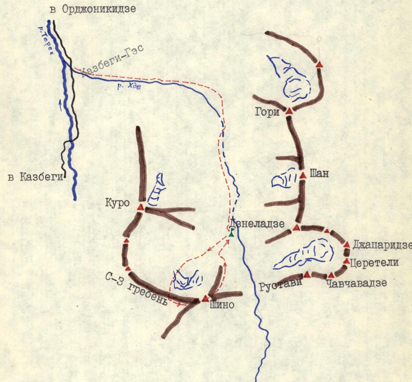
Orographic map-scheme of Khde (Kistinki) gorge
With an overnight stay on the 5th terrace of Khde gorge, ascend along the grassy slopes to the glacier under the North face of Shino and along the right part of the central moraine, bypassing individual crevasses to the right, approach the ice-and-snow ascent of the Central couloir of the North face.
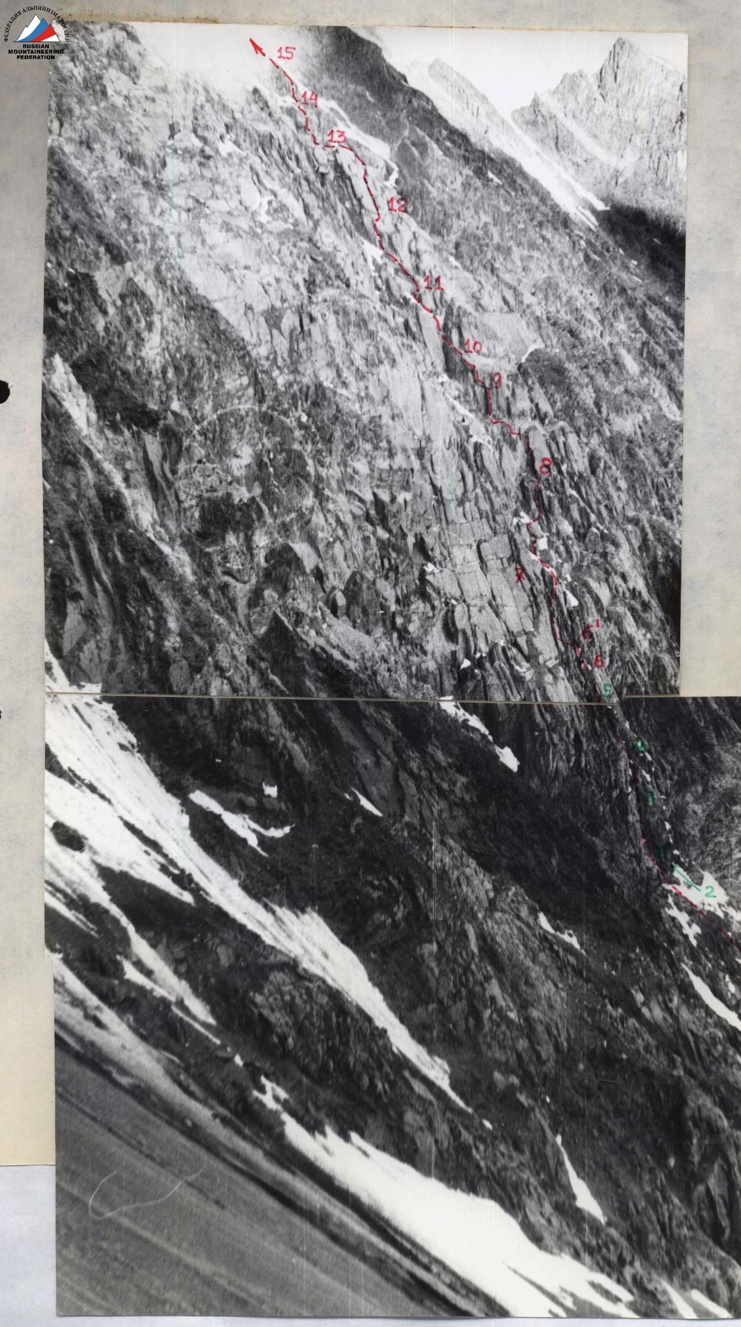
R0–R1. Ascend the steep ice-and-snow ascent in the right part of the large couloir, overcoming the bergschrund, with a 160-meter ascent directly upwards, approach the talus ledge in the middle part of the rocky cape and, traversing the steep ice groove, exit onto the rocks of the cape (this section should be climbed early in the day due to rockfall danger! Piton belay).
R1–R2. Ascend simple, heavily destroyed rocks, rising upwards to the right, approach the base of a not clearly expressed chimney.
R2–R3. Ascend a 20-meter chimney and exit onto an inclined slab (difficult climbing, piton belay).
R3–R4. Traverse along an oblique ledge to the base of the second chimney and ascend a 25-meter chimney - a difficult ascent with an exit into a crack that goes upwards to the right under large slabs on the right part of a not clearly expressed rib (difficult climbing, piton belay).
R4–R5. Ascend a 40-meter crack with an exit onto an inclined ledge (piton belay).
R5–R6. Traverse along snow-covered ledges and slabs, overcoming a 2-meter wall head-on (bypassing it on the right is very rockfall-prone!) - exit onto an icy ledge (difficult climbing, piton belay).
R6–R61. Traverse along a ledge to the base of a chimney and ascend a very difficult 10-meter chimney onto a rib (piton belay).
R61–R7. Overcome narrow talus couloirs with an ascent upwards to the left and exit onto a ledge (belay on rock formations).
R7–R8. Ascend simple talus rocks with an ascent upwards to the right, approach the main monolithic slabs.
R8–R9. Ascend a difficult chimney (loose rocks!) with a 40-meter ascent and exit onto an oblique talus ledge under a white wall.
R9–R10. Overcome the wall via its central inner corner (few holds, difficult climbing, piton belay) with an exit onto a talus ledge under an overhanging rock.
R10–R11. Traverse around the rock along ledges and slabs with few holds, exit into an icy chimney with a plug, and overcome it to exit onto talus ledges (difficult climbing, piton belay).
R11–R12. Ascend talus ledges with an ascent upwards to the right, approach monolithic slabs (belay on rock formations).
R12–R13. Ascend a narrow crack in the center of large slabs - a 40-meter ascent with an exit onto a narrow ledge (piton belay).
R13–R14. Ascend a narrow chimney with a plug and a smooth slab with a 40-meter ascent onto a wide ledge (difficult climbing, piton belay).
R14–R15. From the ledge, ascend a very narrow chimney upwards to the right with an exit onto an inclined slab and, overcoming the right part of a wall, exit onto an inclined ledge (very difficult climbing, piton belay).
R15–R16. Ascend 25 meters upwards to the right along simple rocks, exit onto a ledge (piton belay).
R16–R17. Ascend 40 meters directly upwards along ledges and slabs, approach the ice-and-snow ascent (piton belay).
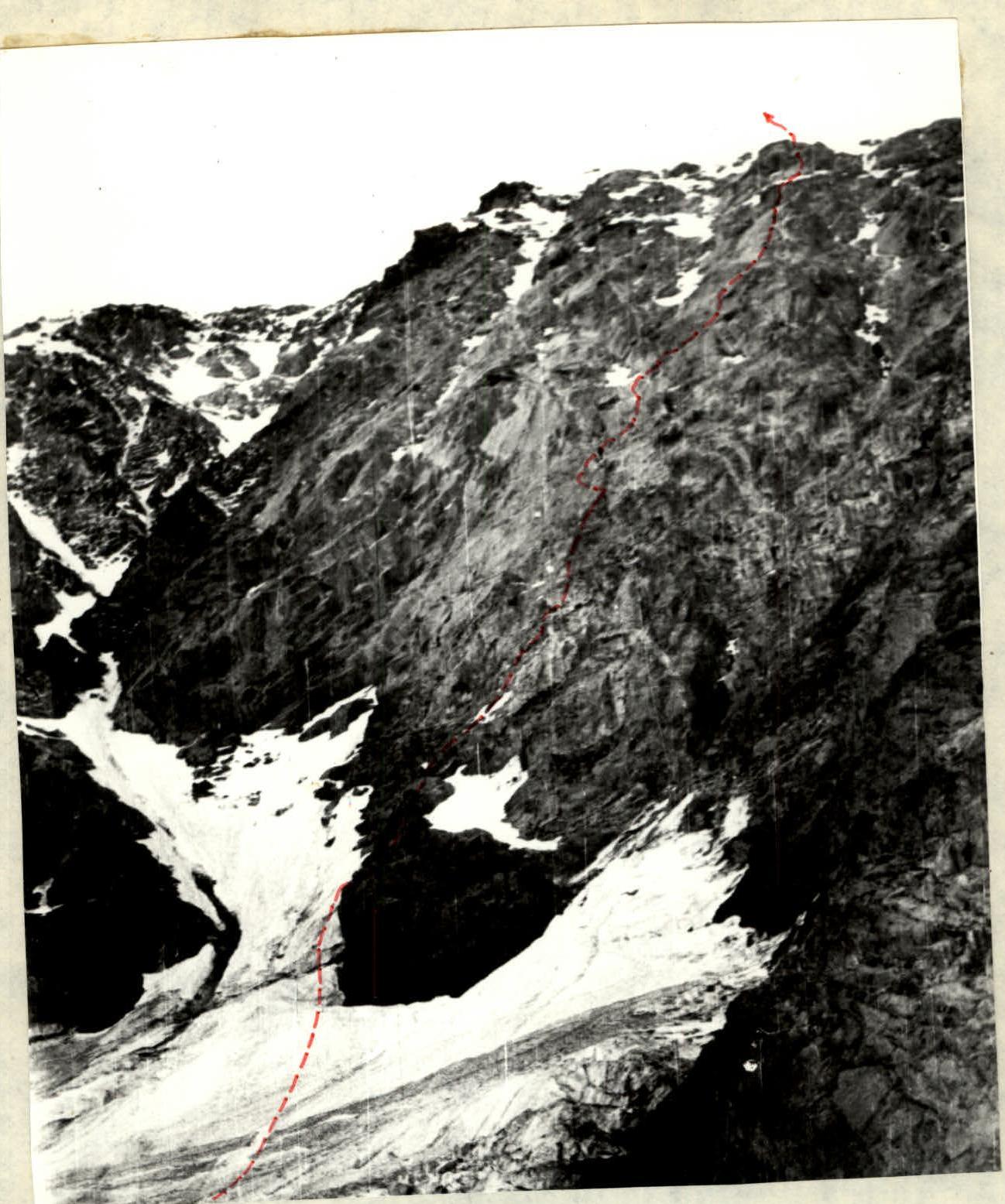
R17–R18. Overcome a 15-meter steep ice slab, exit onto steep snow-covered slabs and ascend them for 10 meters to the base of overhanging rocks (difficult transition from ice to rocks, piton belay).
R18–R19. Traverse 10-12 meters to the left along a very narrow ledge and ascend ledges with an exit onto simple rocks (piton belay). On the ledge in the middle part of the rocks - overnight stay; 13 hours from the initial bivouac.
R19–R20. Ascend 40 meters directly upwards along simple rocks and exit under the ice-and-snow ascent (piton belay).
R20–R21. Ascend 35 meters along an ice-and-snow ridge with subsequent traverse to the left (piton belay).
R21–R22. Bypass an ice dome on the left - a 160-meter traverse upwards to the left along a steep ice-and-snow ascent with an exit onto a rocky outcrop (piton belay).
R22–R23. Ascend a steep ice ascent 140 meters directly upwards with an exit onto an ice-and-snow ridge (difficult ice, piton belay).
R23–R24. Ascend 100 meters directly upwards along an ice-and-snow ridge and exit onto the Northwest ridge of Shino (piton belay).
R24–R25. Traverse 400 meters along a simple ridge (cornices!) with individual rock outcrops, exit onto Shino peak. 5 hours from the overnight stay on the ledge. Descent via the 2A category route (Shino from Kistinki gorge).
The description was compiled by the team leader

Javakhishvili Ts.D.
Route diagram
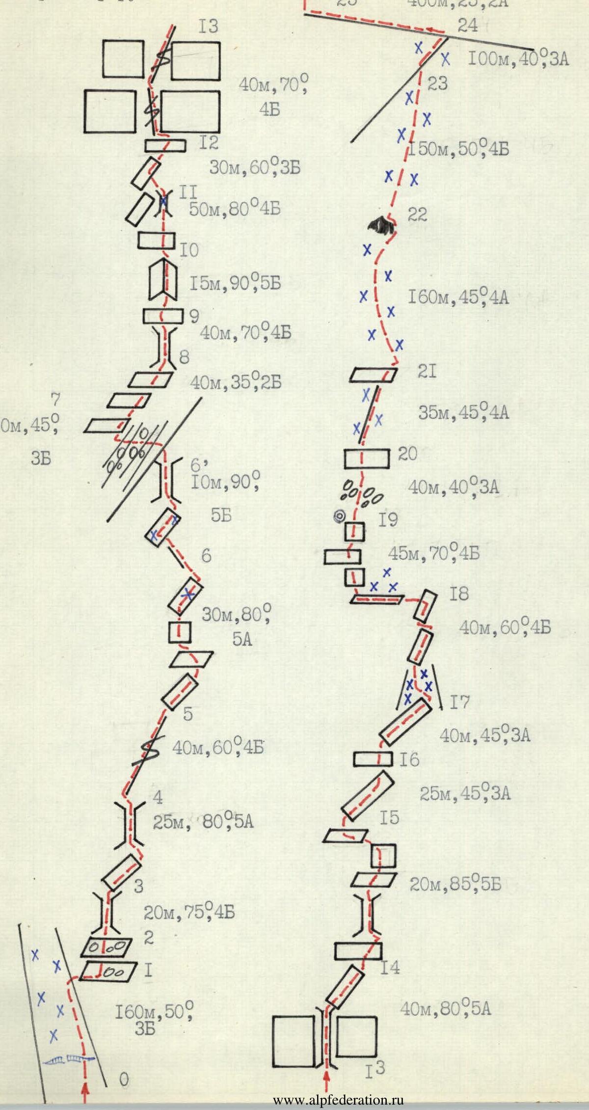
Table of main characteristics of the ascent route
| Date | Section # | Length in m | Average steepness | Terrain character | Difficulty | Condition | Weather | rock | ice | chocks |
|---|---|---|---|---|---|---|---|---|---|---|
| 1 | 2 | 3 | 4 | 5 | 6 | 7 | 8 | 9 | 10 | 11 |
| 26.07.85 | R0–R1 | 160 m | 50° | ice-and-snow ascent | 3 | reliable ice | good | - | 3 | - |
| R1–R2 | 100 m | 40° | ledges | 2 | talus rocks | - | - | - | 1 | |
| R2–R3 | 20 m | 75° | chimney | 4 | monolith | - | 2 | - | - | |
| R3–R4 | 25 m | 80° | slab, chimney | 5 | monolith | - | 4 | - | - | |
| R4–R5 | 40 m | 60° | crack | 4 | monolith | - | 2 | - | 2 | |
| R5–R6 | 30 m | 80° | inclined ledges, wall | 5 | monolith | - | 4 | - | 1 | |
| R6–R61 | 10 m | 90° | chimney | 5 | monolith | - | 4 | - | 1 | |
| R61–R7 | 30 m | 45° | rib, ledge | 3 | talus rocks | - | - | - | 1 | |
| R7–R8 | 40 m | 35° | ledges | 2 | talus rocks | - | - | - | - | |
| R8–R9 | 40 m | 70° | chimney | 4 | loose rocks | - | 2 | - | 2 | |
| R9–R10 | 15 m | 90° | inner corner | 5 | monolith | - | 3 | - | 1 | |
| R10–R11 | 40 m | 80° | snow-covered slabs | 4 | loose rocks | - | 2 | - | 2 | |
| R11–R12 | 30 m | 60° | ledges, slabs | 3 | monolith | - | - | - | - | |
| R12–R13 | 40 m | 70° | crack | 4 | monolith | - | 2 | - | 1 | |
| R13–R14 | 40 m | 80° | chimney, slabs | 5 | monolith | - | 4 | - | 1 | |
| R14–R15 | 20 m | 85° | chimney, wall | 5 | monolith | - | 4 | - | 2 | |
| R15–R16 | 25 m | 45° | slabs | 3 | monolith | - | 1 | - | - | |
| R16–R17 | 40 m | 45° | ledge, slab | 3 | monolith | - | 1 | - | 1 | |
| R17–R18 | 40 m | 60° | ice slab, slabs | 4 | reliable ice, talus | - | 2 | 1 | 1 | |
| R18–R19 | 45 m | 70° | ledges, wall | 4 | loose rocks | - | 3 | - | 1 | |
| 27.07.85 | R19–R20 | 40 m | 40° | ledges | 3 | talus rocks | - | - | - | - |
| R20–R21 | 35 m | 45° | ice-and-snow ridge, rocks | 4 | loose rocks | - | 2 | 1 | - | |
| R21–R22 | 160 m | 45° | ice-and-snow ascent | 4 | unreliable ice, snow | - | - | 6 | - | |
| R22–R23 | 140 m | 50° | ice ascent | 4 | reliable ice | - | - | 10 | - | |
| R23–R24 | 100 m | 40° | snow ridge | 3 | unreliable snow | - | - | 1 | - | |
| R24–R25 | 400 m | 25° | pre-summit ridge | 2 | talus rocks | - | - | - | - |