Malaya Kaidzhany (3700 m)
via the Eastern ridge, Cat. 1B–2A
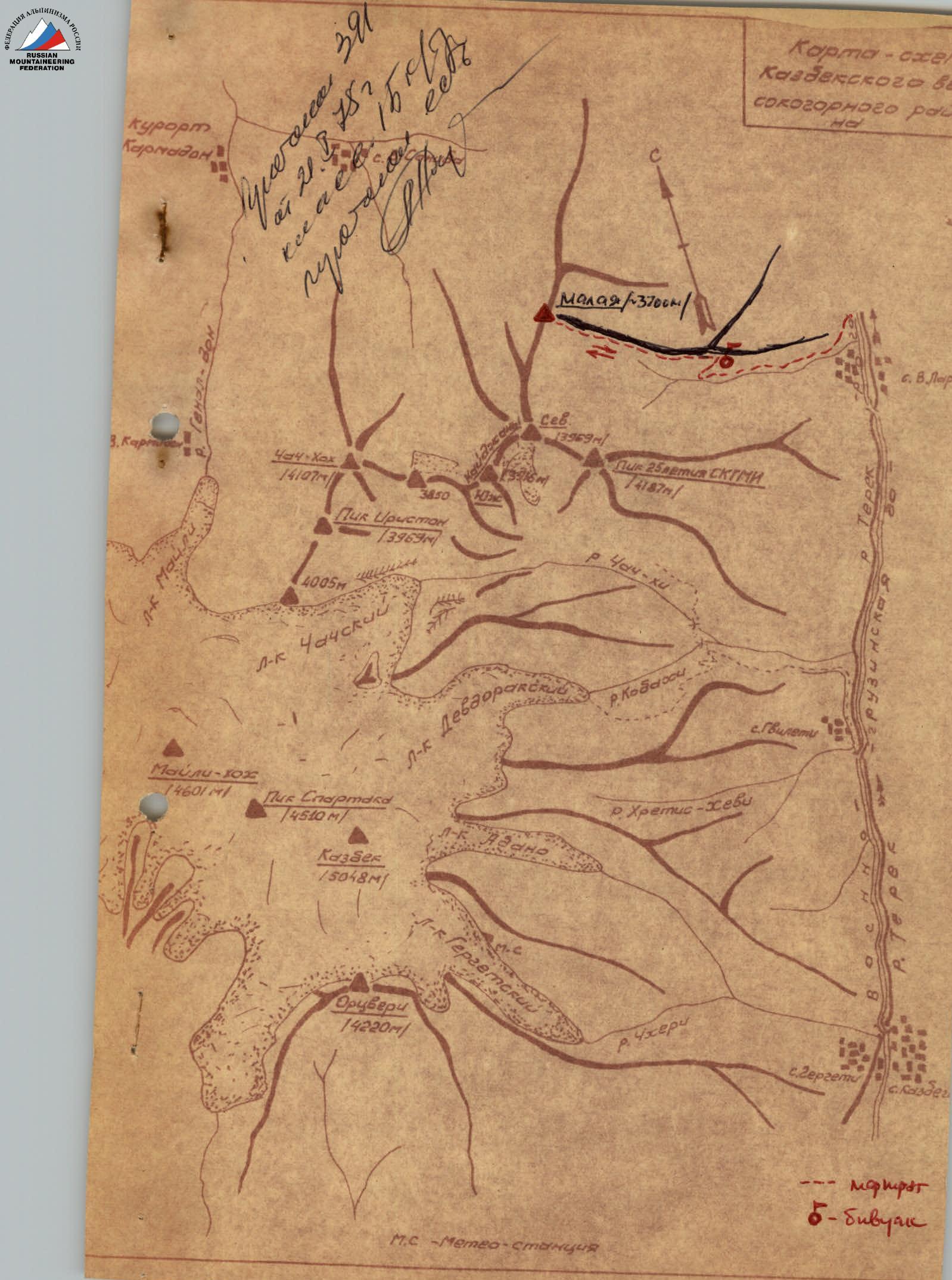
The summit is situated on the eastern boundary of the Central Caucasus. It is the northernmost summit in the northern spur of Pik Spartaka.
- To the south, Malaya Kaidzhany is connected by a ridge to Severная Kaidzhany (3969).
- To the north, a long ridge descends to Sanibanskii pass (1800 m).
- To the east, the Eastern ridge steeply descends into the Darial gorge.
The summit was first ascended by B. Gолубев's team in 1947, traversing the Kaidzhany massif from the north. The Eastern ridge was climbed by V. Kuprin's team in 1971, and has been repeated several times since.
Departure from Ordzhonikidze along the Military Georgian Highway to Verkhnii Lars village. 200–300 m before Verkhnii Lars, a trail (abandoned road) branches off to the right into the Belaya Rechka gorge. Be cautious on the trail, as the slopes of the Belaya Rechka gorge are steep. After 2–2.5 hours of walking, the trail joins another one descending from the right slope at a wider part of the gorge, and follows it onto the Eastern ridge of Malaya Kaidzhany. The broad, grassy ridge-koши offers good camping spots. The camping altitude is 2000 m (according to the altimeter).
The path continues along the ridge. The ridge:
- is steep and grassy at the beginning of the ascent;
- then becomes gentler and continues with a significant gain in altitude until rock outcrops appear on the ridge (3020 m according to the altimeter).
The rocks are solid, with good handholds. The route is well visible. Climbing is easy.
At an altitude of 3050 m, a 7–8 m high "gendarme" is encountered, which can be climbed:
- directly (in case of heavy snow cover);
- or bypassed on the right by a traverse.
It is necessary to rope up before the "gendarme". After passing the "gendarme" (1 rope length), the route continues onto a несложный скальный гребень (2 rope lengths) with subsequent overcoming of a series of small "gendarmes" on the left via ledges (2 rope lengths). Belaying is done through rock outcrops. Further on, a narrow saddle connects to a steep rocky ascent at an angle of 45–50°, which breaks off to the left with slabs. After 10–12 m, the path follows the ridge with a slope of 30–35° — along a narrow ridge (1.5–2 m wide), (1 rope length).
In the middle of this section, there is a narrow spot with a 2–2.5 m high wall. It is necessary to hang a handrail. The rope is secured to rock outcrops on the ridge, which are abundant.
After this section, the ridge widens, and individual rock outcrops are bypassed on the right or left via snow and scree. At an altitude of 3400 m, the ridge joins the slopes of the summit ridge, with a slope steepness of 45–50°. The ridge is very narrow. In spring and winter, due to prevailing northwesterly winds, there are bilateral cornices! The rocky route ends here. Further on, the path follows the summit ridge for 150 m to the summit ascent. The summit ascent (45–50° steepness, 50–70 m long) is scree-covered. Descent is via the same route. The route takes 6–6.5 hours of walking from the campsite to the summit. Descent takes 2–2.5 hours.
Equipment required for a 6-person team:

2 x 50 m main ropes, 4 rock pitons, 1 hammer.
The description was compiled by
B.F. Plyuta. Photos by Proskuryakov R.P.
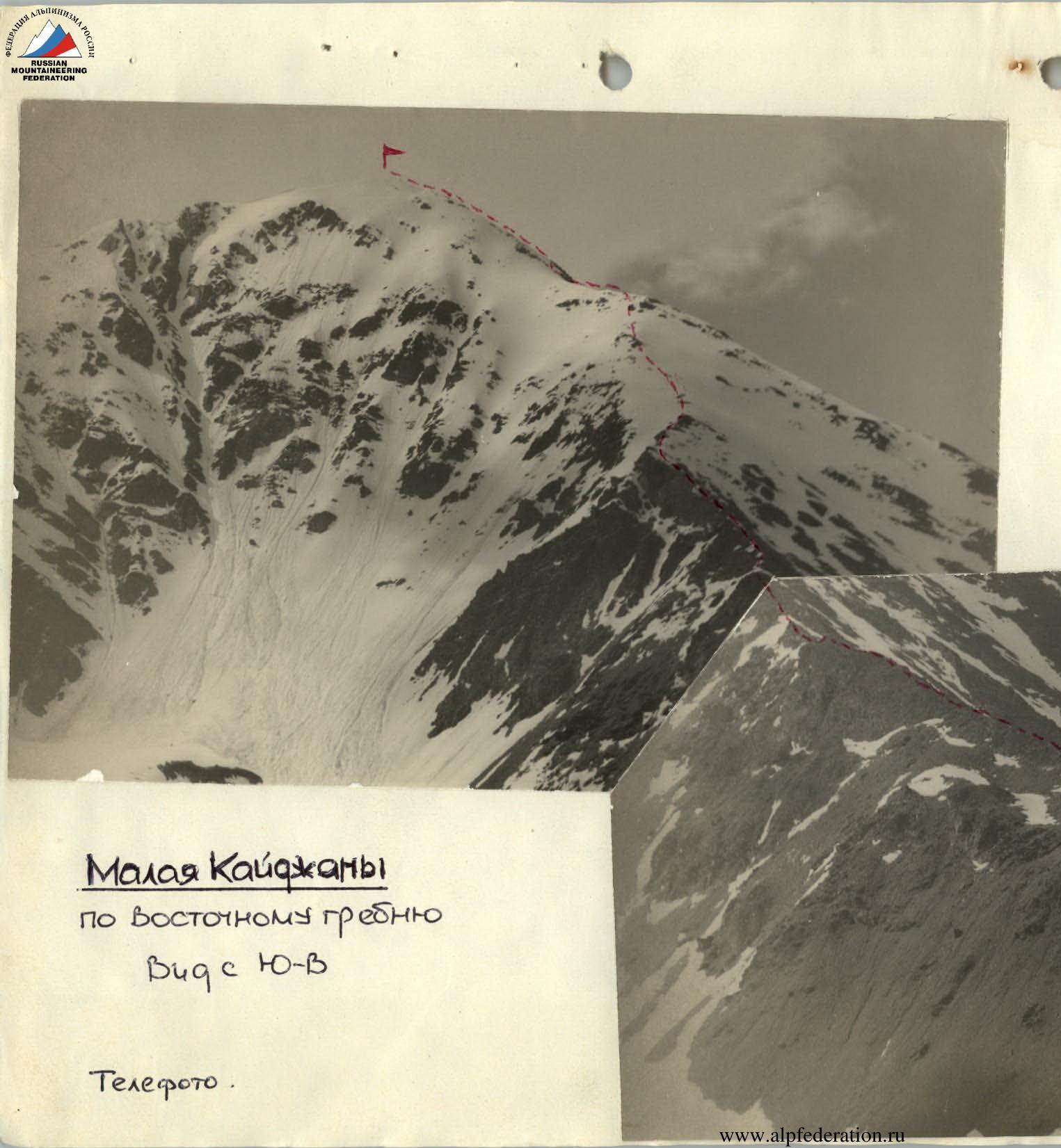
Malaya Kaidzhany
via the Eastern ridge View from SE
Telephoto.
 www.alpfederation.ru↗