
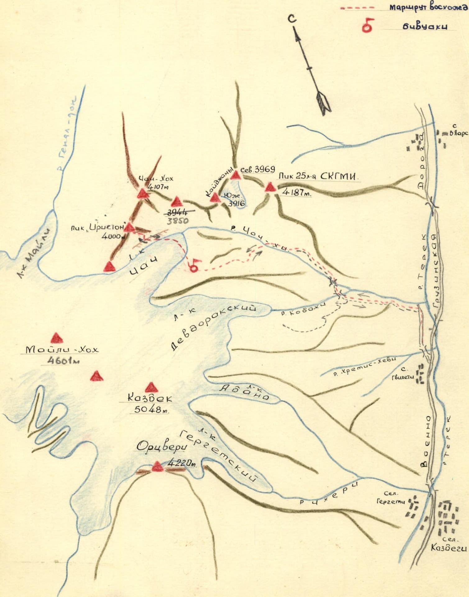
Route Description
Ascent to the Nameless peak (4000 m above sea level) (Peak "Iriston") 1A category of difficulty.
The peak is located in the watershed ridge (between the Genaldon and Chachkhi river basins) connecting the Kazbek firn plateau with the Chach-khokh peak (4100 m). The immediate neighbors of the peak in the ridge are from south to north:
- Ordzhonikidzevskaya railway peak (4300 m)
- Chach-khokh.
The first ascent was made on October 25, 1964 from the Chach gorge by a group of the Spartak Council of the DSO in the amount of 7 people led by L. Tabolov.
Day 1. The group reaches the village of Gvileti by car, from where it takes no more than 1 hour of walking along a dirt road to the confluence of the Kabakhi and Chachkhi rivers. After crossing the pedestrian bridge over the Kabakhi River and overcoming the steep ascent of the trail, they head along the trail to the right (Chach) gorge. The trail leads to the second bridge, which should be crossed to the left (orographic) bank of the Chachkhi River. Here, on the slope, there are many trails, which, however, all lead to the gate of the Chach gorge (height difference of about 300-400 m). In this area, it is recommended to navigate to a single birch tree growing under the wall of the first "gate", heading higher up the slope.
Having overcome the "ram's foreheads" of the "gate" along one of the shelves dividing them, one should:
- go up along the grassy slope to a group of trees,
- from which the trail begins,
- enter a wide couloir along the trail,
- cross the stream,
- after which the trail leads sharply to the right under the rocks,
- following along which, it expands and leads to a shoulder forming the first "gate" of the gorge.
From the first bridge to the pass point of the first "gate" is about 1 hour 30 minutes of walking. The "ram's foreheads" must be passed carefully with gymnastic belay. From the pass point, a view of the Chach gorge in the middle course of the Chachkhi River opens.
Along the trail, traversing grassy slopes and a number of scree couloirs, one can reach the second "gate" of the gorge in 40 minutes, which is a small rocky narrow passage in the river floodplain. The descent to the "gate" is along the scree. The "gate" can be passed:
- along the left (orogr.) slope of the gorge,
- or directly in the river floodplain.
Before the "gate" there is a terrace on the right (orogr.) bank (under the slopes of the Bart-Kort ridge), where one can organize an overnight stay.
From the second to the third "gate" it is more convenient to move along the trail in the river floodplain. After 40 minutes of walking, they reach the place of expansion of the floodplain before the third "gate", where it is convenient to organize a bivouac and where a wide trough-shaped couloir descends from the slopes of the Kaijany massif, originating in the trough of the Kaijany glacier.
Day 2. The third "gate" is passed on the left along the grassy slope, following the slopes of Bart-Kort. Having climbed up, they find themselves in the Chach basin, which is a huge trough-shaped circus, littered with scree, moraines and preserving in its southwestern part the tongue of the Chach glacier descending from the Kazbek plateau, from under which the Chachkhi River originates.
Above the third "gate" of the gorge, one can conveniently locate a bivouac, from which one can ascend to the peaks surrounding the Chach basin. From here, one should move to the Chach glacier, the tongue of which is crossed at the narrowest point, after which it is necessary to climb onto a steep hill of the left-bank moraine of the glacier with a height of 50-70 m. Along the ridge of the hill, one should walk 300 meters to the place where the pocket formed by the moraine and the slopes of the Nameless peak narrows and the slope descends directly to the top of the moraine. They exit onto this scree slope, which should be ascended directly to the massif of the peak. Higher up, the slope becomes steeper - up to 35°. Having passed along the small and medium scree of the slope for about 500 m, they reach the "red stones", from which they go sharply to the left to a small saddle connecting the spur limiting the couloir on the left with the eastern ridge of the peak. They go to the ridge from the saddle with simultaneous belay 300 meters along easy rocks; having reached the rocky ascent (height 30 meters and steepness 60-70°), they overcome it with a fixed rope belay and exit onto a ledge, from which a gentle, 30° steepness, slab with a length of 1.5 ropes goes up. On the slab, a fixed rope belay is also recommended. The slab leads to a large-block scree with 25° steepness and about 100 m length, descending from the line of the eastern ridge. From the place of exit to the ridge upwards, there are quite steep destroyed rocks, which after 150 meters form a narrow jagged section of the ridge, 20 meters long ("knife"). The section is passed with simultaneous belay. Further, becoming more gentle and wider, the ridge leads to the summit after 1 rope - a wide area on which a cairn was built.
The ascent to the peak from the moraine takes 4 hours. Descent along the ascent route to the exit point on the eastern ridge, and then to the left down the couloir (along snow and scree). One should descend carefully, taking cover behind rock outcrops from possible rockfall.
The descent to the glacier takes 2.5 hours. The ascent corresponds to the technical difficulties of 1A-1B category of complexity.
The description was compiled by L. Tabolov, R. Proskuryakov.
Map-scheme
Ascent to Peak "Iriston" 2A category of complexity.

Peak "Iriston" (4000 m), view from the East (telephoto).