Route Description for Climbing Arkhon Maly Peak (3942 m)
Category II-B difficulty. The peak is located in the Teplinskaya group of the Front Range of the Greater Caucasus, on the northeastern spur of Kolota, immediately adjacent to the Arkhon Glavny peak (4253 m) to the southwest.
The first ascent to Arkhon Maly was made by a group of climbers from Ordzhonikidze led by N. Alchiev on May 29, 1966, from the Fiagdon valley via the southwest ridge.
Day I. Traveling from Ordzhonikidze through the Kurtatinskoye gorge to the confluence of the Fiagdon and Dzamarashdon rivers takes 2 hours 30 minutes. Cross the Fiagdon River via a bridge near a watchtower and follow the trail up to the first hanging valley (on the left orographic slope of the gorge). The ascent proceeds up a grassy slope, which becomes quite steep at the top, leading to a moraine hill. The moraine ridge is sharp, with avalanche debris from Glavny Arkhon on both sides.
On the first day, the ascent reaches an absolute height of 3000 m. At the junction of the moraine and the slope, a bivouac is set up on a small site. The ascent to the bivouac takes 3 hours.
Day II. Depart at 5:00 AM. After proceeding 100 m along the moraine, turn right and ascend the slope to the eastern buttress of the northeastern ridge of Arkhon.
Upon reaching the ridge of the buttress:
- form a rope team;
- move up the ridge.
The slopes of the ridge to the left are gentler, while to the right are walls with overhanging massive cornices, so caution is necessary. After 3 hours of ascent, reach the junction of the eastern buttress and the northeastern ridge of Glavny Arkhon (southwest ridge of Arkhon Maly).
To reach Arkhon Maly, turn right (in the direction of travel). The ridge is sharp in places, with cornices to the west. Travel 1–1.5 m off the ridge line along the fairly steep bend of the snow-covered southeastern slope of the ridge. Move with mutual belay. The ridge has three gaps. The first gap, 15–20 m high, can be traversed in two ways: the first option is to descend 30–40 m to the right (downhill) along a 45–50° slope (with protection via outcrops) and bypass the gap along a ledge, using rock pitons (two pitons). This option is advisable with a significant amount of snow. The second option is a 20 m rappel down the ridge. The second gap, 15 m high, is traversed "head-on" with protection via a piton. The ridge between the second and third gaps is snowy and sharp, requiring a "straddling" crawl. The third gap is small and not complex; it is traversed along a small ledge to the right, with unstable rocks.
After the third gap, there is a 150 m ascent to the summit. The summit of Arkhon Maly (3942 m) is a heavily destroyed tower with sheer walls. The journey from the ridge junction to the summit takes 3 hours. Descent follows the ascent route.
Recommended equipment for a group of 4:
- Main ropes 30 m - 2 pieces
- Rock pitons with long blades - 6 pieces
- Hammers - 2 pieces
- General-use carabiners - 6 pieces
- 5 m Prusik cords - 4 pieces
The description was compiled by:  N. Alchiev, R. Proskuryakov.
The first ascent group consisted entirely of climbers with category III ratings and above. Observer-instructor: R. Proskuryakov. 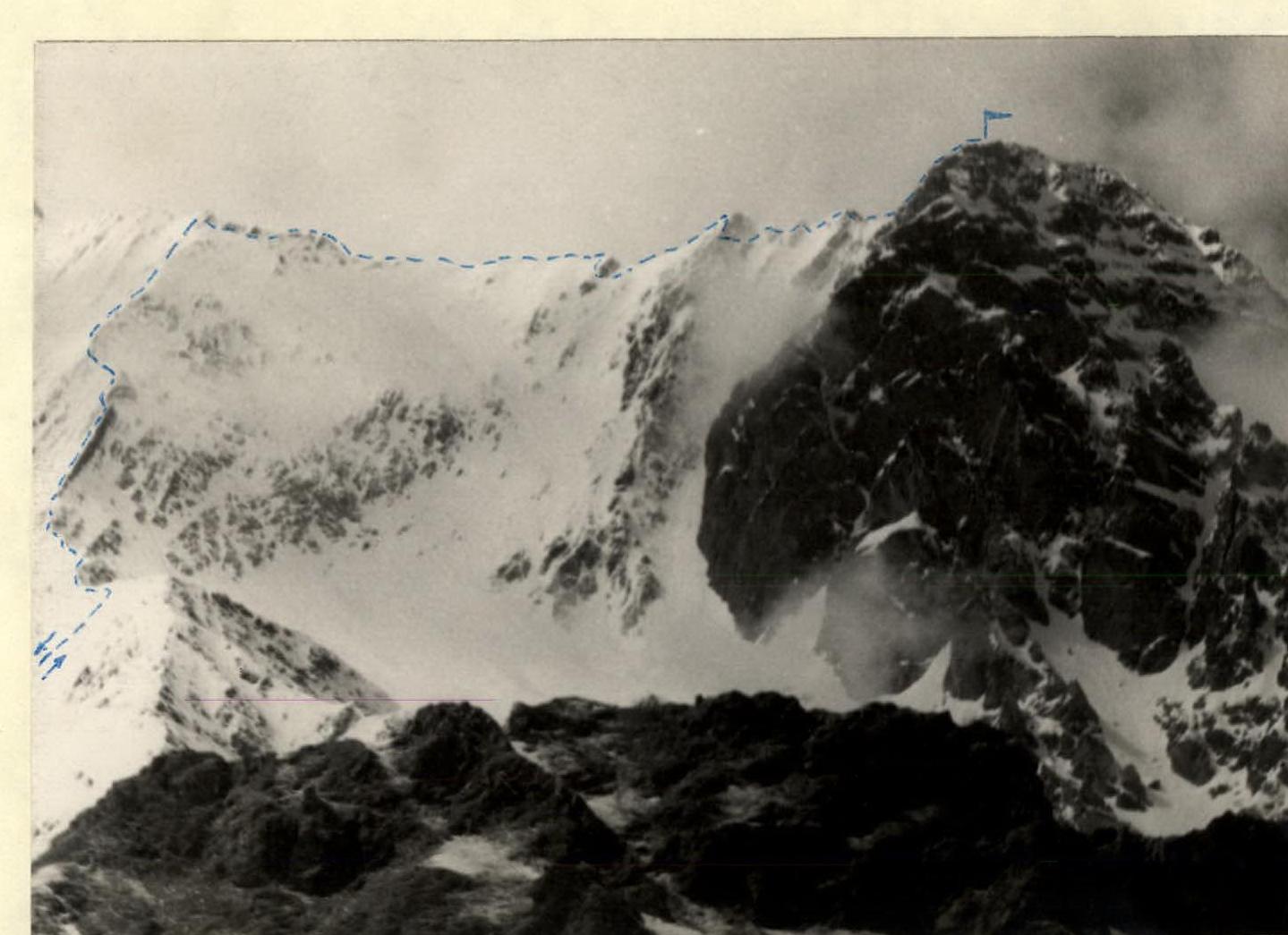
Arkhon Maly (3942 m)
View from the East Route via the southwest ridge, Category II-B difficulty. Telephoto by R. Proskuryakov.