REPORT
on the first ascent to the peak of Pavel Fitin via the Northwest ridge, category 3A difficulty level, by the team of the alpinism club "Cascade", from August 4 to 6, 2020.
2020
1. Ascent Passport
| № | 1. General Information | |
|---|---|---|
| 1.1 | Full name, sports rank of the leader | Egorin S.V. — Master of Sports |
| 1.2 | Full name, sports rank of the participants | Zemlyakov D.S. — 3rd sports rank, Kurchavov A.V. — 1st sports rank, Maximov D.S. — Candidate Master of Sports |
| 1.3 | Full name of the coach | Krutikov D.A. |
| 1.4 | Organization | Alpinism Club "Cascade" |
| 2. Characteristics of the Ascent Object | ||
| 2.1 | Region | North Ossetia, Soudor (Saudor) ridge |
| 2.2 | Valley | Karaugom |
| 2.3 | Number according to the 2020 Classification Table | 2.2.7 |
| 2.4 | Name and height of the peak | Pavel Fitin, 4076 m |
| 2.5 | Geographical coordinates of the peak | 42°49.3′ N, 43°46.0′ E |
| 3. Characteristics of the Route | ||
| 3.1 | Name of the route | Northwest ridge |
| 3.2 | Proposed difficulty category | 3A |
| 3.3 | Degree of route exploration | First ascent |
| 3.4 | Character of the route terrain | Rocky |
| 3.5 | Elevation gain of the route | 500 m |
| 3.6 | Length of the route | 950 m |
| 3.7 | Technical elements of the route | Category I ice/rock/combination — 200 m Category II ice/rock/combination — 400 m Category III ice/rock/combination — 200 m Category IV ice/rock/combination — 148 m Category V ice/rock/combination — 2 m Dülfer descent (on descent) — 250 m |
| 3.8 | Descent from the peak | Via the ascent route |
| 3.9 | Additional characteristics of the route | Presence of water (snowfields on the Western slope) |
| 4. Characteristics of the Team's Actions | ||
| 4.1 | Time of movement | 8 hours, from Mikelay meadow |
| 4.2 | Overnight stays on the route | none |
| 4.3 | Departure for the route | 5:00, August 5, 2020 |
| 4.4 | Reaching the peak | 13:00, August 5, 2020 |
| 4.5 | Return to the base camp | 19:00, August 5, 2020 |
| 5. Person Responsible for the Report | ||
| 5.1 | Full name, e-mail | Egorin S.V., e.s.128@mail.ru |
Pavel Fitin
 3743.0 m
2. Technical Characteristics of the Route Sections
| Section | Character of the terrain | Difficulty category | Length, m | Type and number of pitons |
|---|---|---|---|---|
| R0–R1 | Rocky-talus couloir | 1–3 category | 400 m | - |
| R1–R2 | Rocky-talus, Western slope | 1–3 category | 400 m | - |
| R2–R3 | Rocky ridge | 3–5 category | 60 m | 2 wedges, 3 pitons |
| R3–R4 | Rocky ridge | 2–4 category | 40 m | 2 wedges |
| R4–R5 | Rocky ridge | 2–4 category | 50 m | 3 wedges |
3. Characteristics of the Team's Actions
3.1 Description of the Approach to the Route
From the city of Vladikavkaz, travel to the border post in the village of Dzinaga, approximately 125 km. At the border post, obtain a permit to enter the border zone (Mikelay meadow area).
Beyond the village, along the Karaugomdon River, begin the ascent via the trail. Elevation 1500 m. Almost immediately, a rocky outcrop needs to be circumvented. It is necessary to go left upwards, along a steep slope among trees and bushes, with a subsequent descent back to the old trail after half an hour. Circumventing this section in rainy conditions and with heavy backpacks requires utmost caution.
The path continues through the forest, along an old and visible trail. The trail leads to a bridge over the Karaugomdon River within 1.5–2 hours from the start. After crossing to the right bank of the river, continue the ascent through a pine forest and approach the lateral valley of Iska. Crossing the stream flowing from this valley is done by fording. In case of high water, insurance along the banks is necessary.
Upon approaching the Rayskaya meadow, the river flowing from the Fastag valley is crossed via a good bridge. The journey from the village of Dzinaga to the Rayskaya meadow takes 4–5 hours. Elevation gain is 500 m.
From the meadow, ascend upwards under the trees, along a steep slope of an old moraine. After 1.5 hours, upon reaching the crest of the moraine, the Karaugom glacier becomes visible. Small, marshy lakes are visible in the moraine pockets to the right below. After the third lake, one needs to find a path down to the glacier along a gentle, conglomerate slope of the lateral moraine of the Karaugom glacier.
Upon descending to the glacier, head towards the lowest point of the opposite slope, the right-bank moraine of the glacier. Behind this moraine lies the Mikelay meadow — 2500 m.
After crossing the Karaugom glacier, cautiously ascend along the steep, partially destroyed slope of the moraine. The ascent line constantly changes due to the conglomerate slope being frequently washed away by rains.
A river with clear water flows through the meadow. Overnight stay is possible here. The journey from the village of Dzinaga takes 8–9 hours.
Mobile phone coverage is available only up to the Rayskaya meadow (MTS).
It is recommended to use the offline application "Maps.Me" for smartphones during the approach. The trail up to the third lake is marked in this app.
The further path of our movement is along the river flowing through the meadow. It is better to walk alongside the river, on stones, as the grass is tall and there is a lot of dew in the mornings.
Initially, head South, then the Mikelaydon River turns East, and after an hour or one and a half hours, it disappears under old, overgrown moraines.
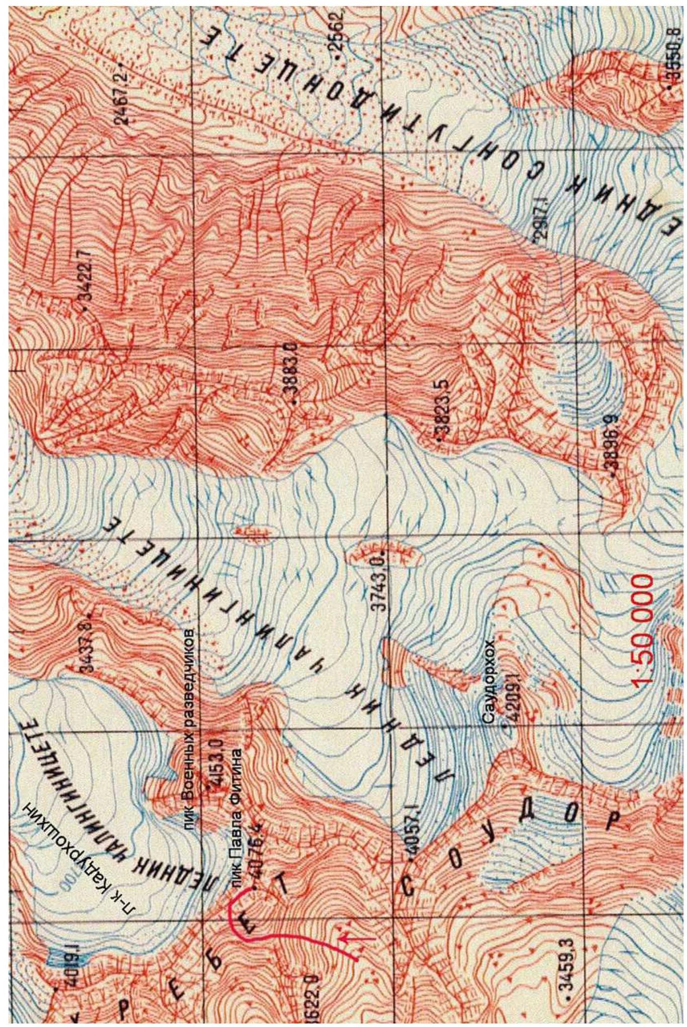
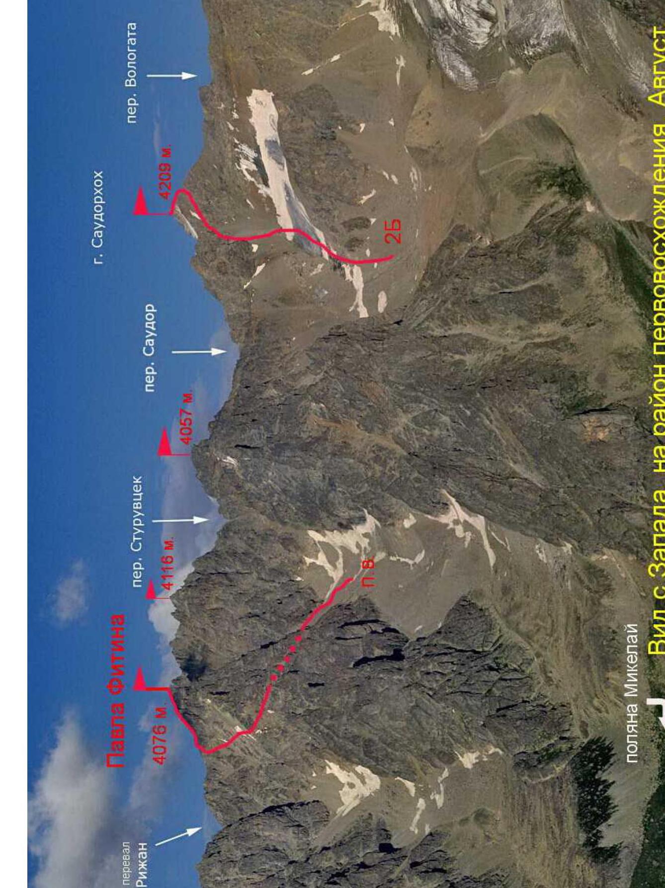
Continue upwards along the talus, towards a deep saddle between two glacier-covered peaks. Behind the saddle begins a rocky ridge — a spur descending from the peak of Pavel Fitin and separating two valleys.
The left valley leads to the Rizan pass, the right one — to the Sturvcek (Sturuvcek) pass. Both passes lead through the Saudor ridge into the upper cirque of the Kadurkhoshkhin glacier. We ascend via the right valley.
The valley is steep and quite narrow. Snowfields are present in the first half of the summer.
In the left part of the visible rocky walls ahead, two talus couloirs are visible, merging at the lower part:
- The leftmost one, with a rocky outcrop in the upper part;
- The right couloir — narrow and steep.
Our route follows the left couloir. The height at the beginning of the couloir is 3600 m.
3.2 Brief Description of the Route Passage
| Section | Description | Photo number |
|---|---|---|
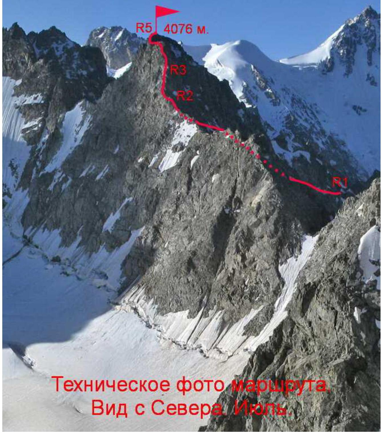
| R0–R1 | Ascend the left talus couloir to the base of the rocky outcrop in the upper part of the couloir. Before reaching the saddle of the ridge, traverse right, under the reddish rocks, into the right upper "narrow" couloir. From there, exit onto the ridge — the spur separating the two valleys. The couloir contains many loose rocks! Ice is possible. It is also possible to enter this couloir by reaching the saddle above the rocky outcrop and traversing right along the rocks of 3–4 category, 60 m. | Photo 1 |
| R1–R2 | From the shoulder of the ridge-spur, traverse the Western slope of the peak of Pavel Fitin, right upwards — towards the shoulder on the Northwest ridge of the peak. The path goes through and along small counterforts with couloirs between them (snowfields). The terrain is heavily destroyed. The rocks of the summit tower are visible from above. | Photo 2 |
| R2–R3 | Upon reaching the Saudor ridge, turn right and ascend mainly along the ridge line. The key section is category 5, 2 m, at the end of the rope, when exiting over the ridge bend. The belay station is on a ledge. Section length is 60 m. | Photo 3 |
| R3–R4 | The pre-summit ascent is also along the ridge line, and then along a simple ridge to the saddle under the summit tower. | Photo 4 |
| R4–R5 | Ascend to the summit along the Northwest ridge, bypassing complex sections, mainly on the left. The summit area is not large. | Photo 5 |
3.3 Recommendations
No signs of human presence were found on the summit. The ascent route taken by the group to the peak of Pavel Fitin is the most optimal path from the West. Descent from the summit is best done via the ascent route. We descended into the left valley, under the Rizan pass. The descent there proved to be more complicated — the terraces of the Western slope end in rocky drops. Therefore, it is faster to descend via the ascent route.
Attention: — Many loose rocks!
The traversed route along the Northwest ridge is safe with proper ascent tactics and is the easiest path to the summit. The route corresponds to category 3A difficulty.
The report uses photographs from the first ascent group and photos from https://caucatalog.ru↗
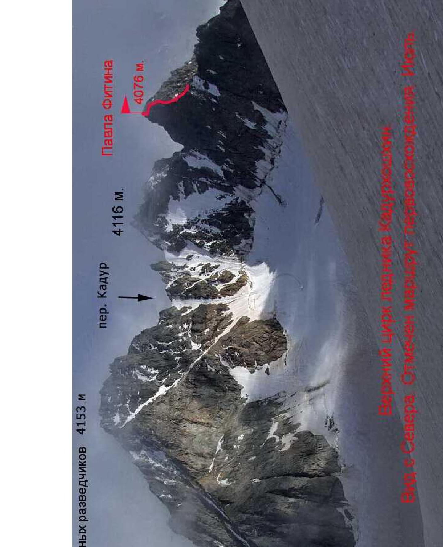 Upper cirque of the Kadurkhoshkhin glacier. View from the North.
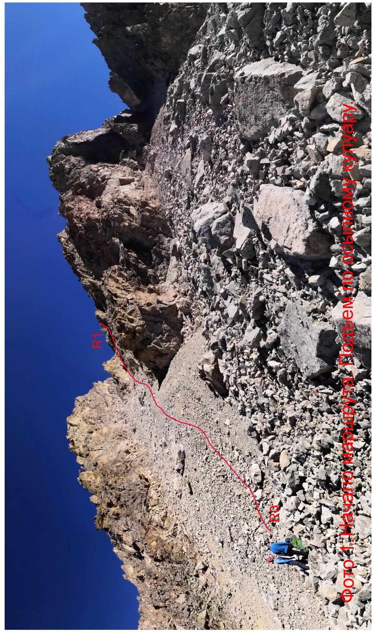 Photo 1. Beginning of section R0–R1.
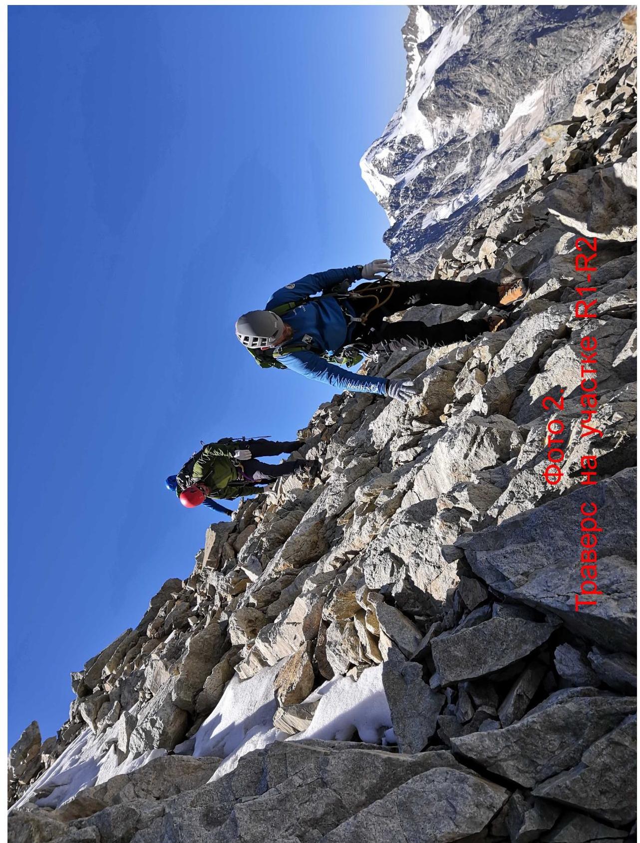 Photo 2. Passage of section R1–R2.
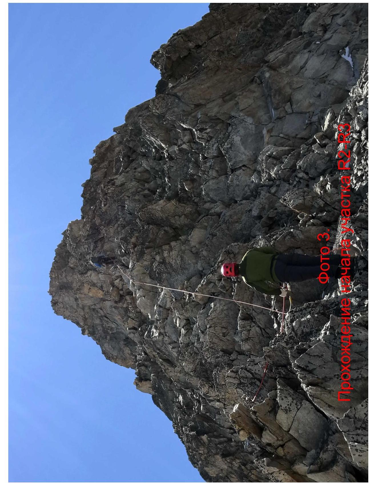 Photo 3. Passage of section R2–R3.
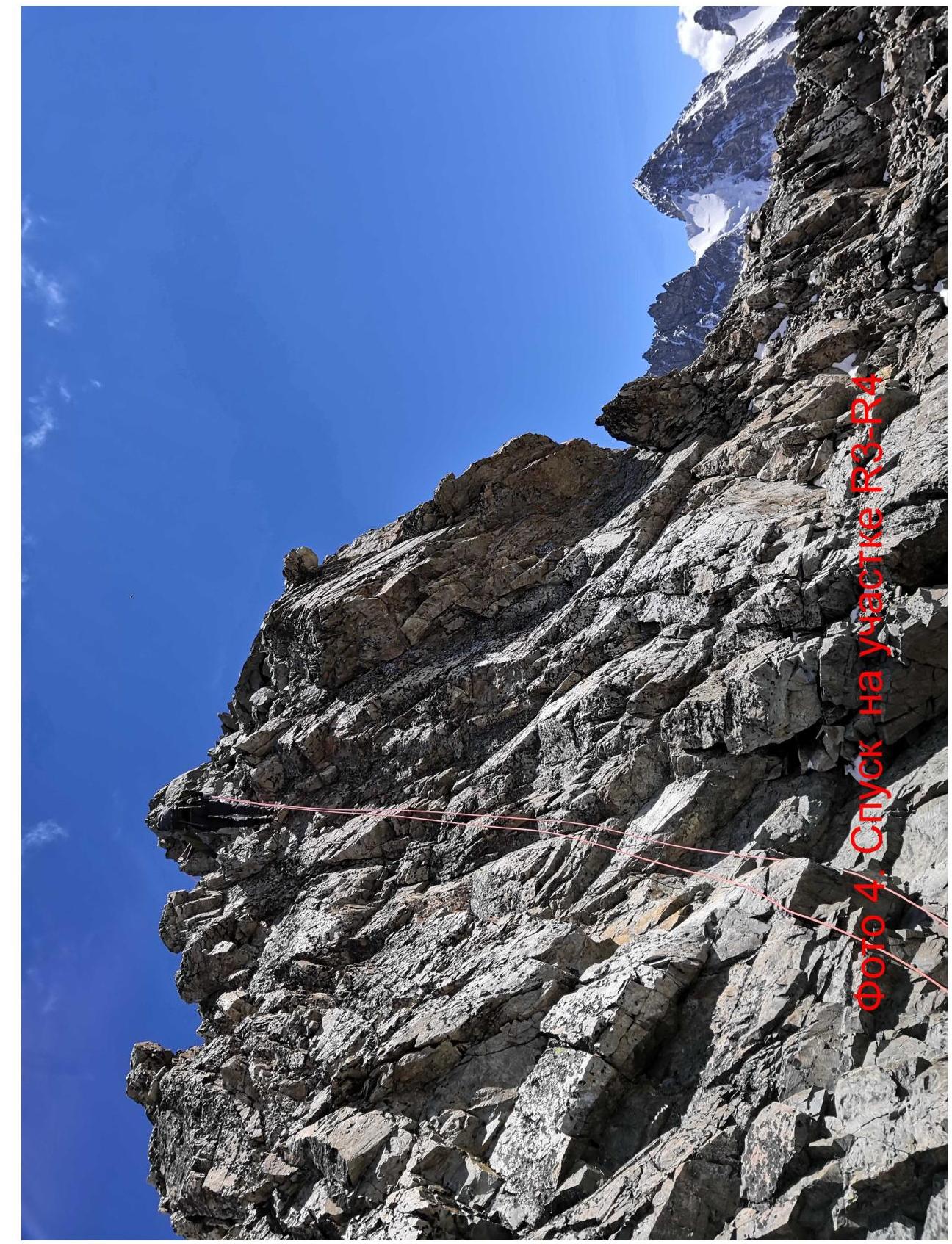 Photo 4. Passage of the beginning of section R3–R4.
 Photo 5. Passage of the beginning of section R4–R5.
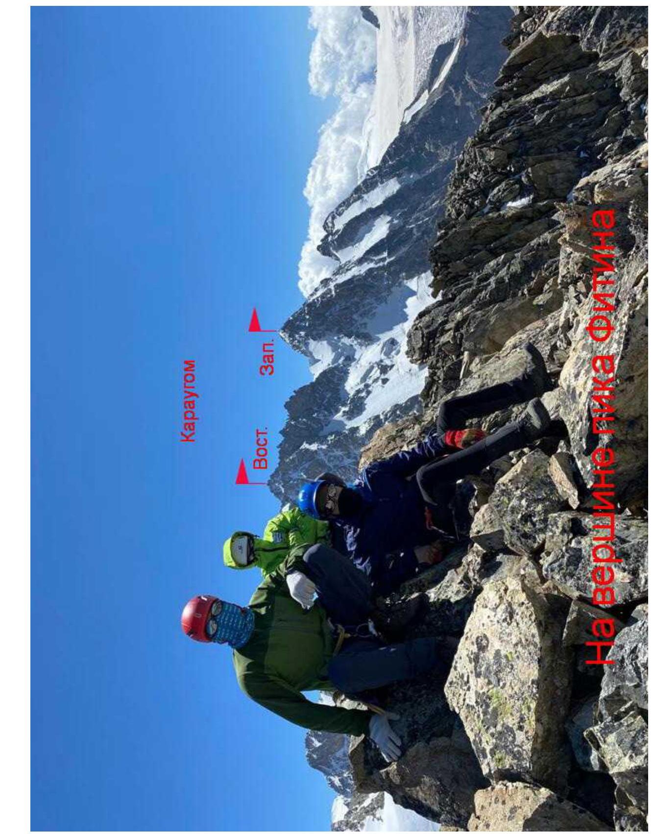 On the summit of Fitin peak.
 Logo of Alpinism Club "Cascade".
Government of the Russian Federation
Decree
dated February 18, 2020 № 332-r
MOSCOW
In accordance with the Federal Law "On Names of Geographical Objects" and based on the proposal of the Parliament of the Republic of North Ossetia — Alania, as well as to commemorate the memory of the head of foreign intelligence during the Great Patriotic War, Lieutenant General Fitin P.M., assign the name "Pavel Fitin" to the unnamed mountain with coordinates 42°49.3′ North latitude, 43°46.0′ East longitude, and an absolute height of 4076.4 m, located on the Soudor ridge in the territory of the Irafsky district of the Republic of North Ossetia — Alania.
Chairman of the Government of the Russian Federation
M. Mishustin
Footnotes
-
View from the West, at the area of the first ascent. August. ↩