Report
on the first ascent route on the summit Chančahi 4461 m via the center of the North wall (proposed 6A category) by the team of Sumy regional FaiS from February 3 to 11, 2014.
Team captain: Roško V. I.
Team coach: Mitühin F. P.
Sumy — 2014
Addresses:
Coach Mitühin Fedor Petrovich 40004, Sumy, Metallurgov str., 14/67 ph. home +38 (050) 634-34-34 ph. work 8 (0542) 61-99-64
Leader Roško Vladimir Ivanovich
40024, Sumy, Prokofieva str., 31/1, apt. 6 ph.: +38 (050) 965-76-37 Determination of altitudes was carried out using an altimeter; steepness was determined visually and in the AutoCAD program.
Ascent Passport
- Ascent class — winter.
- Ascent area — Caucasus, Tsey gorge.
- Summit Chančahi (4461 m) via the Center of the North wall.
- Proposed — 6A category, first ascent.
- Route height difference — 940 m.
main part — 730 m. Route length — 1065 m main part — 745 m Section lengths:
- 6th category — 265 m (including 253 m of ITО)
- 5th category — 230 m (including 25 m of ITО)
Average route steepness — 60°, Average steepness of the wall part of the route — 70°.
- Pitons driven:
Rock 127, Bolts 5 (including 3 for the platform), Chocks 76, Ice 32.
- Team's walking hours — 33 h, 6 days (including 3 days of processing).
- Overnights: 2 overnights on the wall — on a platform (during processing in a tent under the wall).
- Leader: Roško Vladimir Ivanovich — Master of Sports of International Class (MSMK)
Members: Venslavovskiy Dmitriy Aleksandrovich — MSMK, Shimko Nikolay Nikolaevich — Candidate for Master of Sports (CMS), Mironchak Mikhail Vadimovich — CMS
- Coach: Mitühin Fedor Petrovich — Master of Sports (MS), Honored Coach of Ukraine (ZТУ).
- Departure on the route:
February 9, 2014 (February 3, 4, 8 — processing), summit — February 11, 2014,
return to Base Camp — February 11, 2014
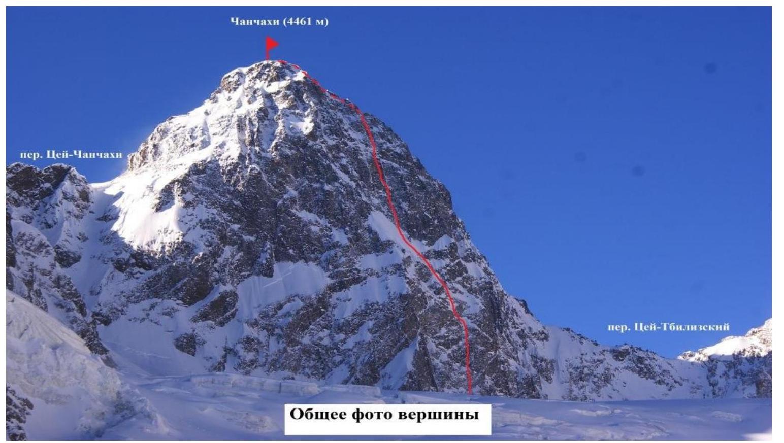
General photo of the summit. Mt. Chančahi (4461
m)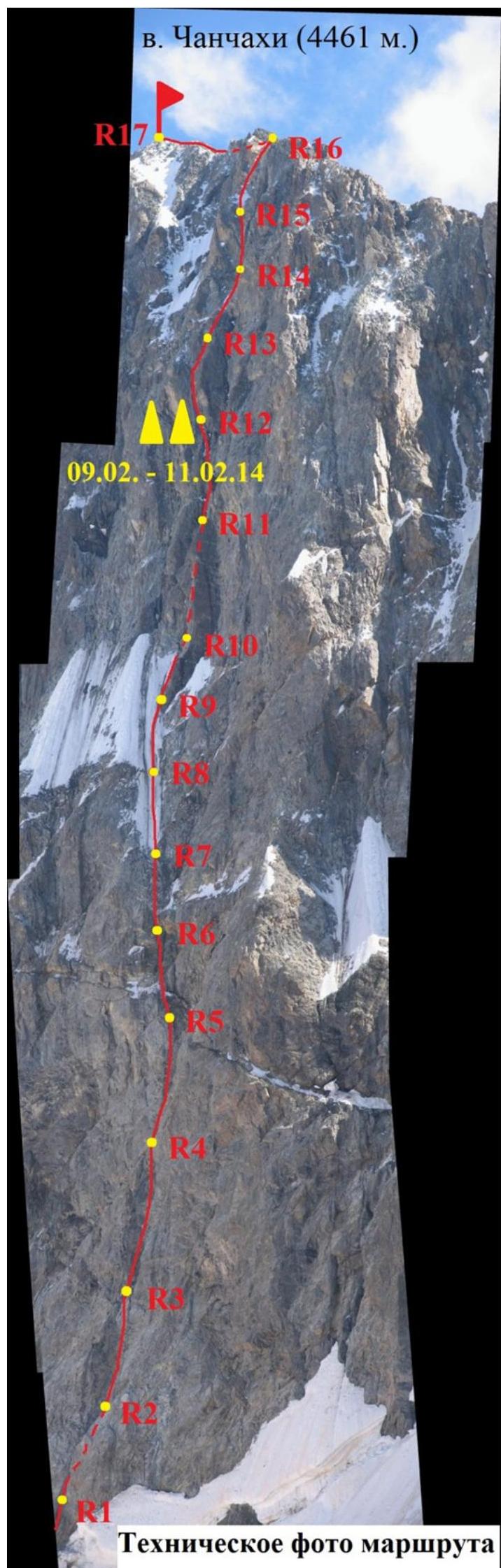
Drawn Route Profile
Brief Overview of the Ascent Area
The Tsey glacier is surrounded on three sides by mountain ridges, which form the Big Tsey horseshoe. The horseshoe begins with the Monakh rock, rising above the forest near the confluence of the Skazdon river with the Tseydon. Here are located the Tsey alpine camp and the Control and Supply Point (CSP) of the Tsey region.
From Monakh, a rocky ridge with a glaciated ascent to the summit Kalberg rises to the nodal summit Adai of the Kalper ridge, running along the eastern side of the Tsey glacier.
From Adai, the horseshoe continues with the Kalper ridge with the summits Zaromag, Ronketti, and passes into the Eastern ridge of the nodal summit of the Main ridge — Mamison.
The small eastern spur of Mamison with the peaks Nikolaeva and Khitsan divides the upper Tsey glacier into the North and South branches.
From Mamison, the Big Tsey horseshoe runs along the Main ridge with the summits:
- Chančahi
- Bubis
and limits the upper North branch of the Tsey glacier.
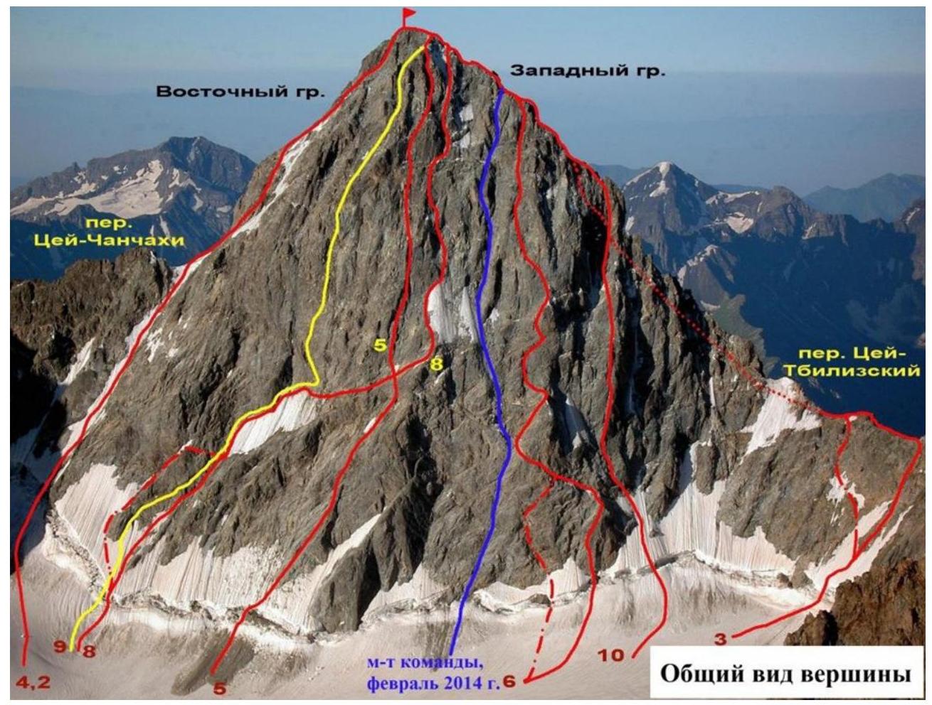
The pyramid Chančahi (4461 m), one of the most difficult to access peaks in the Caucasus, is located in the Main ridge, between the nodal summits Mamison to the east and Bubis to the west.
To the south, glaciers Tbiliza and Chančahi descend from the summit and its long South ridge with avalanche- and rockfall-prone slopes.
Above the North branch of the Tsey glacier, Chančahi rises with sheer rocky bastions of the North wall, "opened" to mountaineers by a group led by V. Abalakov.
Rockfalls are common on the North wall of Chančahi, as they are on the South slopes.
The western part of the Big Tsey horseshoe is formed by the Tsey ridge, stretching from Bubis along the northwest side of the Tsey glacier. The summits of the Big Tsey horseshoe are well освоены by mountaineers and are frequently visited by them.
The approach to Mt. Chančahi takes about 8–10 hours in the summer. In winter, it is logical to break the approach into two days:
- Day 1: approach to Nikolaevskaya hut — takes 6–9 hours;
- Day 2: approach to the North cirque under Chančahi — takes 4–5 hours.
In winter, the climate is very harsh — strong frosts and hurricane-force winds. The wall is completely shaded. Only the summit is slightly lit. In winter, routes on the North wall are quite safe.
A detailed description of the routes and approaches can be found in the book by A. F. Naumov "Karaugom, Digoriya, Tsey".
Tactical Actions of the Team
01.01.14. Cargo delivery and overnight stay at Nikolaevskaya hut. The approach from Tsey alpine camp to Nikolaevskaya hut took 9 hours. Lots of snow. We walked in snowshoes. 02.01.14. Descent and rest at Tsey alpine camp. 01.02.14. Delivery of the remaining cargo to Nikolaevskaya hut. 02.02.14. Delivery of part of the cargo to the North cirque of the Tsey glacier. Setup of ABC under the wall of Chančahi. Clear weather, but very cold. Temperature below −20°C at night in the tent. 03.04.14. Duo Roško — Shimko processed the route. On the section R0–R1, the bergschrund had to be overcome by digging a trench with an avalanche shovel. Many "mushrooms" on the rocks complicate the movement. We managed to process 120 m that day. Duo Venslavovskiy — Mironchak descended to Nikolaevskaya hut for the remaining cargo. Clear weather, but strong frost. The wall is completely shaded.
February 5, 2014. Bad weather. Hurricane-force winds.
February 6, 2014. Bad weather. Hurricane-force winds. The team descended to Nikolaevskaya hut.
February 7, 2014. Bad weather. Strong frost, wind.
February 8, 2014. Shimko — Roško, processing. That day, they processed 140 m and reached the "ice field". The rope was fixed on R7, and the first overnight stay from the Popov route was clearly visible on the right. Venslavovskiy — Mironchak made a cargo trip — delivered the main part of the cargo and the platform to R7. Clear weather, frost eased.
February 9, 2014. The whole team departed. Movement across the (ice field) allowed them to accelerate significantly. The inner corner — couloir turned out to be more complicated than expected. Section R11–R12 — one of the key sections on the route. They found a place for an overnight stay only by 18:00. Hung the platform at 20:00. That day, in addition to the processed ropes, they managed to cover another 245 m. Good weather.
February 10, 2014. Venslavovskiy — Mironchak, processing. Hung 130 m. Overnight stay at the same place on the platform at R12. Good weather.
11.02.14. Started ascent on processed ropes at 9:00. Reached the ridge — R16 by 11:00. Left the main cargo on the ridge and were on the summit Chančahi by 13:00. Initially, planned to descend via the West ridge to the Tsey-Tbiliza pass, but the poor condition of the ridge and heavy backpacks led to a change of plan. Decided to descend via the ascent route. Started descent at 14:00 and were down by the tents at 18:30. That day, they also descended to Nikolaevskaya hut.
12.03.14. Descent of all expedition members to Tsey alpine camp.
| Pitons Shl. Chocks Ice. | Diagram in UIAA symbols sheet 1 | Section | Length m. | Steepness | Category | ||
|---|---|---|---|---|---|---|---|
| --- | - | 6 | R8–R9 | 50 m | 55° | IV | |
| --- | 2 | 4 | R7–R8 | 50 m | 55° | IV | |
| --- | 1 | 6 | R6–R7 | 20 m 30 m | 85° 60° | VI IV | |
| --- | 1 | 4 | R5–R6 | 10 m 35 m | 55° 80° | V V | |
| 6 | --- | R4–R5 | 35 m 10 m | 70° 40° | V+ A1 IV | ||
| 1 | 15 | ---- | R3–R4 | 15 m 20 m 5 m | 75° 85° 60° | V+ A1 VI+ A2 V+ | |
| 1 | 10 | ---- | R2–R3 | 13 m 7 m 40 m | 75° 80° | VI A2 IV VI A1–A2 | |
| --- | --- | --- | R1–R2 | 5 m 30 m 10 m | 70° 60° 55° | V+ A1 V IV | |
| 3 | ---- | R0–R1 | 35 m | 80° | VI A1 | ||
| Pitons | Diagram in UIAA symbols | Section | D | Length | Steepness | ||
| :--: | :--: | :--: | :--: | :--: | :--: | :--: | :--: |
| Shl. Chocks Ice. | sheet 2 |
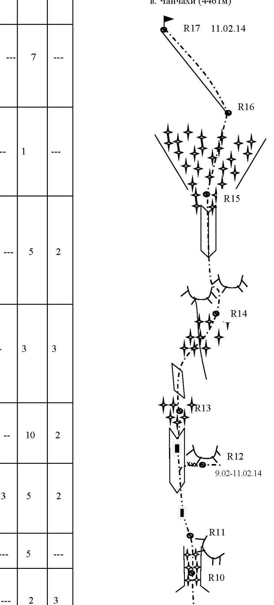
| :--: | :--: | :--: | :--: | :--: | :--: | :--: | :--: | | - | 7 | --- | | | | | | -- | 1 | --- | | R16–R17 | 300 m | 40° | III | | | | | R15–R16 | 35 m | 50° | III | | | --- | 5 | 2 | | | | | | | -- | 3 | 3 | | R13–R14 | 10 m 15 m 20 m | 75° 65° 60° | VI
V
V + | | -- | 10 | 2 | | R12-R13 | 35 M
15 M | $\begin{gathered}
90^{\circ} \ 80^{\circ} \end{gathered}$ | VI+, A2
VI+, A1-A2 | | 3 | 5 |
2 | | R11-R12 | 10 M
10 M
30 M | $\begin{gathered} 65^{\circ} \
90^{\circ} \ 80^{\circ} \end{gathered}$ | $\begin{aligned} & \mathrm{V}+ \
& \mathrm{VI}_{+}, \ & \mathrm{A} 2 \ & \mathrm{VI}, \ & \mathrm{A} 2
\end{aligned}$ | | --- | 5 | --- | | R10-R11 | 45 M | $75^{\circ}$ |
$\mathrm{V}+$ | | --- | 2 | 3 | | 45 M | $60^{\circ}$ | IV | |
Route Description by Sections
The route runs through the center of the North wall of Mt. Chančahi between the Korablev and Popov routes. The starting point is 150 m to the right of the large black inner corner, where the bergschrund approaches the wall closely.
General direction:
- a wide inner corner, filled with ice in the lower part of the wall (clearly visible at the start of the snow slope);
- landmark — the right part of the central snowfield.
In the summer, the route may be objectively hazardous.
In terms of technical difficulty, the route taken by the team is not inferior to the Ruchkin route on the North wall of the peak Svobodnaya Korea (6A).
R0–R1. Approach the bergschrund via a snow slope. Overcome it and continue upwards along a steep snow slope to the rocks. Then move up and to the right — climb onto a "snow mushroom", traverse 5 m to the right, and up onto the rocks. Reach a narrow ledge and traverse it to the right for 5 m to the start of the inner corner — chimney.
Here it is convenient to set up a belay station (if there is no snowfall). In case of snowfall, it is safer to set up a station at the start of the narrow ledge.
- 20 m, 45°
- 35 m, VI, 80°, A1
R1–R2. Initially, climb up the inner corner — chimney, filled with ice, then along a steep ice-snow slope to approach the rocks. Set up a belay station.
- 5 m, V+, 70°, A1
- 30 m, V, 60°
- 10 m, IV, 55°
R2–R3. Climb up through narrow crevices to reach the level of a narrow shelf that goes to the right. Move onto the shelf and traverse it for 7 m to the right. Without reaching the нависание, move strictly upwards along steep rocks, alternating with inclined, ice- filled shelves. Approach the start of a narrow chimney, filled with ice. Climb up the chimney until it becomes less steep. There is a bolt 3–5 m higher. Set up a belay station.
13 m, VI, 75°, A2; 7 m, IV (traverse along the shelf); 40 m, VI, 80°, A1–A2.
R3–R4. One of the key sections! Move upwards along the wall, then traverse left into the inner corner. Climb up the inner corner using ITО, overcome the нависание, and reach more gentle rocks but with significantly poorer relief. There is a bolt 5–7 m higher. Set up a belay station.
- 15 m, V+, 75°, A1
- 20 m, VI+, 85°, A2
- 5 m, V+, 60°, A2
R4–R5. From the station, move upwards through a "rock step", then to the right through the inner corner to reach a steep snow-ice shelf. Set up a belay station on the rocks.
35 m, V, 70°, sometimes A1. 10 m, IV, 40°. R5–R6. Move left and upwards for 10 m, then strictly upwards towards a steep "icicle". Set up a belay station on the rocks to the right.
10 m, V, 55°; 35 m, V, 80°. R6–R7. From the station, move left and upwards along the steep icicle to reach a more gentle "ice field". 20 m, VI, 85°; 30 m, IV, 60°. R7–R10. Climb up the "ice field". Approach the right chimney — couloir, filled with ice. Climb 5 m up the chimney with complex climbing to reach a small shelf. Set up a belay station.
145 m, IV, 55°; 5 m, VI, 80°. R10–R11. Climb up the chimney — couloir for 45 m. 45 m, V+, 75°. R11–R12. One of the key sections! Climb up the chimney, approach a steep rocky wall. The couloir then splits into two (rejoining after 70 m), becoming significantly narrower. We went left. Set up a belay station on the steep wall under the нависание. Here we hung our platform. Two bolts and one piton were placed. (To reach the station, one has to pass through a "live" multi-ton block. There is a feeling that loading it in the summer would make it collapse).
10 m, V+, 65°; 10 m, VI+, 90°, A2; 30 m, VI, 80°, A2. R12–R13. Climb up the inner corner using ITО. After overcoming the нависание, reach an icicle. Set up a belay station on the gentle slope.
35 m, VI+, 90°, A2; 15 m, VI, 80°, A1–A2.
R13–R14. Climb up a slab for 10 m, then move up and to the right to overcome a firn ridge — a snowdrift. Continue upwards on firn — mixed terrain.
- 10 m, VI, 75°;
- 15 m, V, 65°;
- 20 m, V+, 60°.
R14–R15. Move up and to the right along ice formations for 5 m, then climb up through crevices. Traverse up and to the left along the inner corner for 35 m, initially at 80°, gradually becoming less steep to 60°.
- 5 m, V+, 70°;
- 10 m, VI, 90°, A2;
- 35 m, VI, 70°.
R15–R16. From the station, climb up in the direction of a lowering in the ridge. Initially, along an ice-snow slope, then along very destroyed rocks to reach the ridge.
- 35 m, III, 50°.
R16–R17. Continue along the snow-covered rocks of the West ridge, alternating between ledges and walls, to reach the summit Chančahi.
- 300 m, III–IV, 40°.
Protocol
Report on the ascent made by the team of Sumy regional FaiS, a/c "Sumy" within the framework of the Ukrainian Championship 2014 in mountaineering in the winter class on Mt. Chančahi via the center of the North wall, 6B category, first ascent.
From February 3 to 11, 2014.
February 13, 2014. Team composition:
- Roško V.I. — MSMK, team leader.
- Venslavovskiy D.A. — MSMK.
- Shimko N.N. — CMS.
- Mironchak M.V. — CMS.
The report is reviewed by the senior coach, releasing trainer of Sumy regional FaiS — MS, ZTU Mitühin F.P.
Attending the review: Venslavovskiy A.N., CMS — head of the rescue team.
Mitühin F.P. The team a/c "Sumy" has completed a first ascent on Mt. Chančahi via the center of the North wall, proposed 6A category, within the Ukrainian Championship in mountaineering in the winter class.
We ask the participants of the ascent to share their opinions on the technical difficulty of the route, its condition, tactics of the ascent, and adherence to safety measures. Mironchak M.V.
The route is logical and technically complex. It has a significant height difference in the wall part. The team worked very coherently. A peculiarity of the route is the limited number of places for organizing a normal safe overnight stay, especially for groups of more than 2 people.
For organizing a bivouac on the route, it is better to take a platform.
Shimko N.N. Mt. Chančahi is located in the North cirque of the Tsey glacier. In winter, this area is characterized by hurricane-force winds and low temperatures. The wall is completely shaded. The route can be conditionally divided into 4 parts:
- lower bastion — lots of ITО (key section 1);
- ice field — dense firn, местами рыхлый лёд;
- inner corner — couloir, filled with ice, complex mixed terrain + ITО (key section 2);
- pre-summit ridge — 300 m of snow-covered rocks, III–IV category.
Venslavovskiy D.A. The team arrived in the area with their rescue team, communication sessions were held strictly at the designated time, with no omissions. Thus, safety measures were maximally observed.
Roško V.I. I believe that the route is potentially hazardous in the summer. The lower part will be affected by rocks falling from the central snowfield. The upper part of the route passes through gullies coming from the West ridge — rockfall-prone sections.
In winter:
- one needs to "catch the weather"
- during heavy snowfalls, powder avalanches are common on the route
In terms of technical difficulty, the route taken by the team is not inferior to the Ruchkin route on the North wall of the peak Svobodnaya Korea (6A).
Conclusion of Senior Releasing Coach Mitühin F.P. The team has passed the route technically and tactically competently, without violating safety measures, and without deviating from the planned tactical plan. The route's height difference, length, average steepness, and the length of sections of 6th and 5th categories correspond to routes of 6A category. The first ascent of the route is to be counted for all team members, and the guidance is to be counted for the ascent leader. The ascent report is to be submitted to the judging panel of the Ukrainian Championship in mountaineering in the winter class, and a copy of the report is to be submitted to the Classification Commission of FaiS of Ukraine.
Senior releasing coach, MS, ZTU Mitühin
F.P.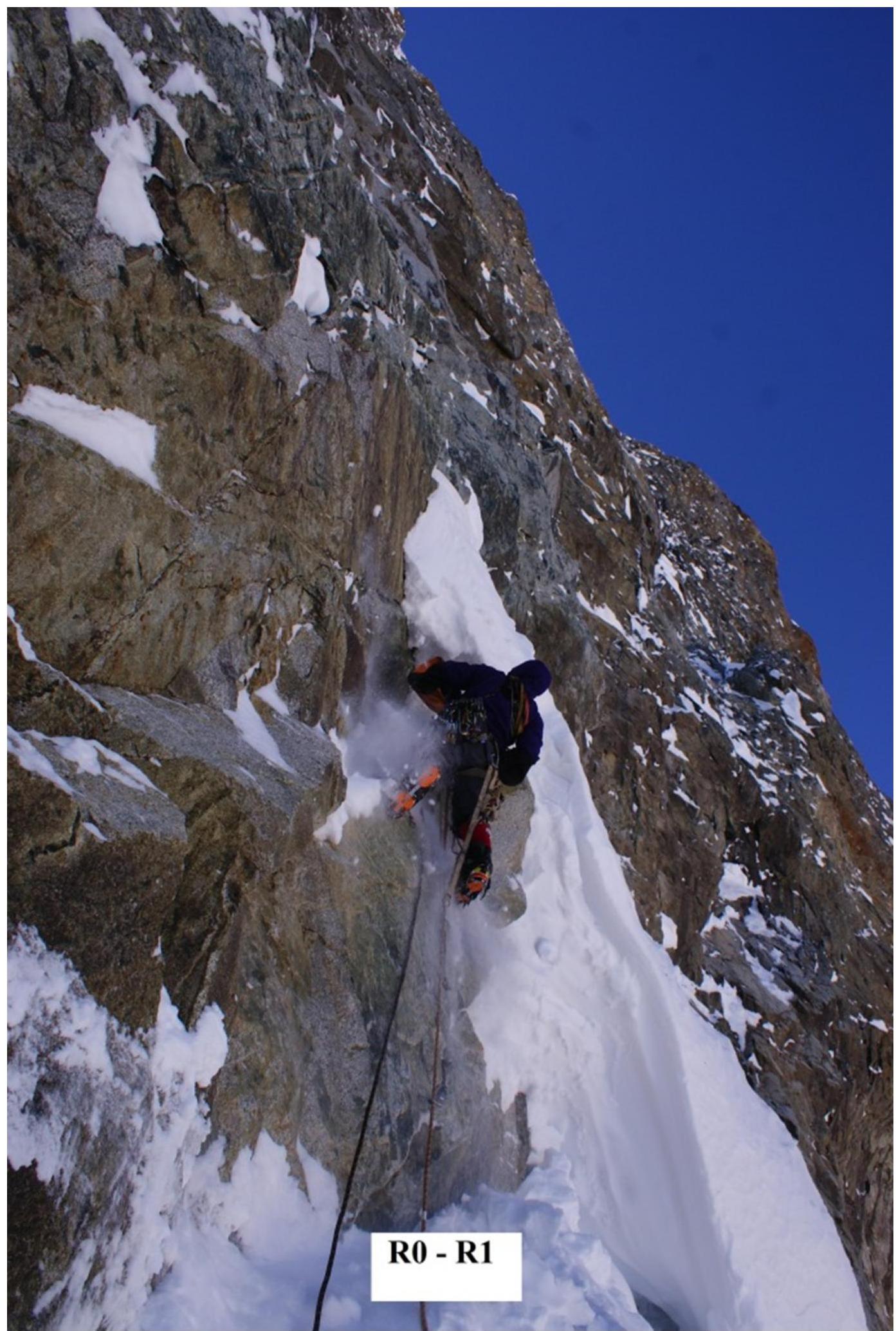
- R0–R1
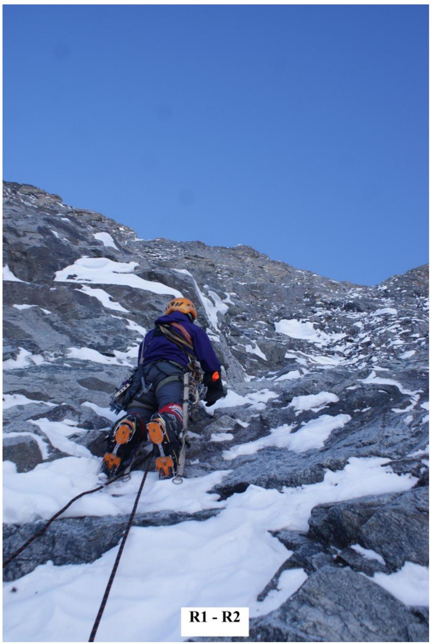
- R1–R2
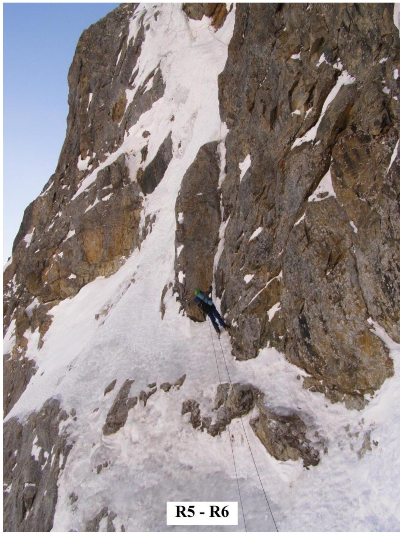
R5–R6

R11–R12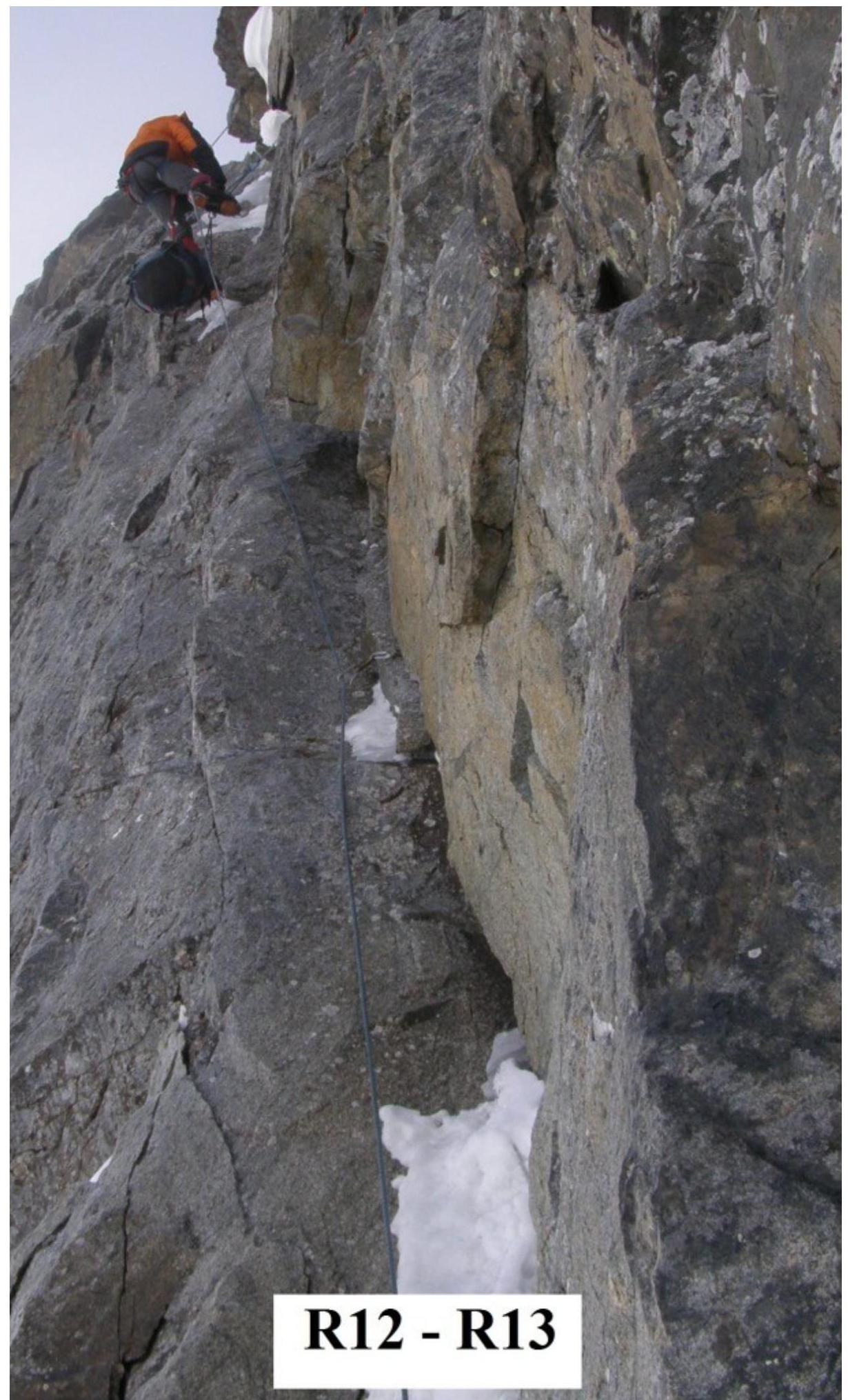
R12–R13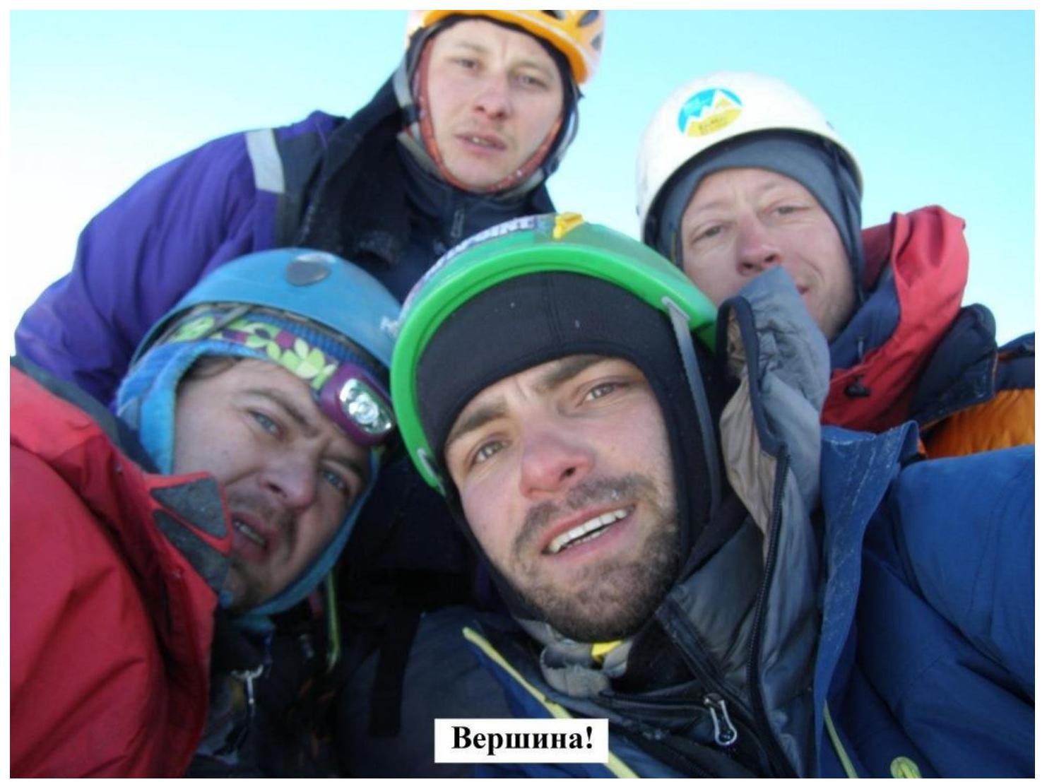
The summit!