Ascent Certificate
- Rock class.
- Caucasus, Tsey gorge.
- Hitsan (3600 m), via the left part of the North face.
- Proposed category 3A, first ascent.
- Route elevation gain 500 m; route length 800 m.
Elevation gain of the wall section 300 m; wall section length 360 m; average steepness of the wall section 60°.
- Pitons hammered:
rock, nuts, bolted 12/0 23/0 0/0
- Team's travel time 8 hours and days – 1.
- Overnight stays: before and after the route at the Tsey hut.
- Leader: Egorin Sergey Vladimirovich, Master of Sports
Member: Gazdarova Olga Valeryevna, 3rd sports category. Coach: Egorin Sergey Vladimirovich, Master of Sports.
- Departure for the route: September 8, 1999.
Summit: September 8, 1999. Return: September 8, 1999.
- Organization: SORPSS EMERCOM of Russia.
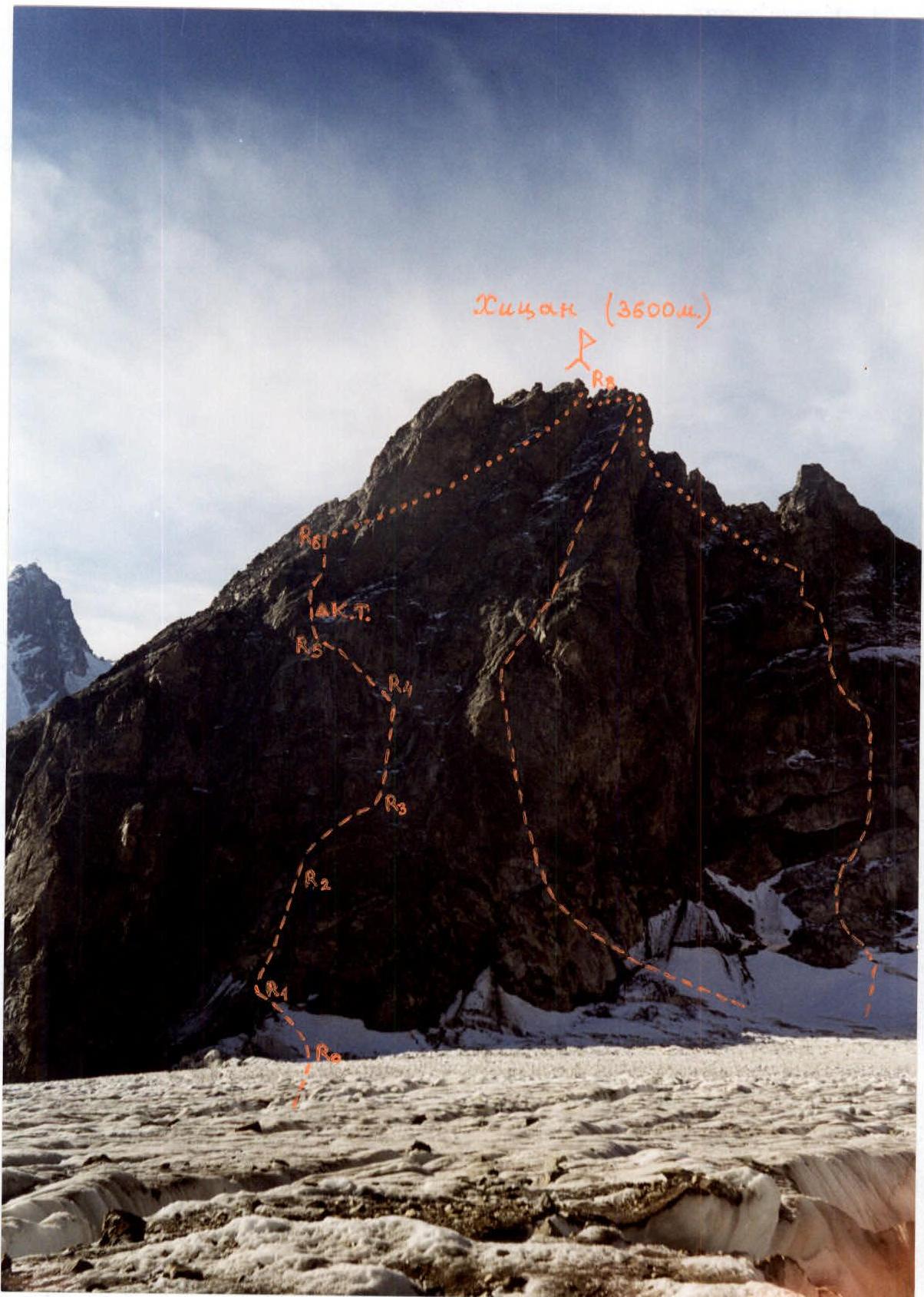
Photo 1. General view of the Hitsan summit from the North. September. Photo from under the southern slopes of SKVO. The first ascent route is marked on the left on the left part of the North face. In the center — the route 4A category via the NW ridge, on the right — 3B via the North face and NW edge.
Scale: 1 cm – 12 m.
Brief description of the route
From the alpine camps of the Tsey region to the Tsey hut 5–6 hours. Departure from the hut early in the morning.
Ascend via the scree couloir to the Hitsan pass and, crossing it, descend to the North branch of the Tsey glacier. In June–July, it is possible to approach the route under the North faces of Hitsan, and in August–September, crevasses must be circumvented, going further onto the glacier. The landmark for the start of the route is a rocky outcrop located below the left part of the North face. Above it, characteristic quartz veins are visible. The time from the hut to the route is 1–1.5 hours.
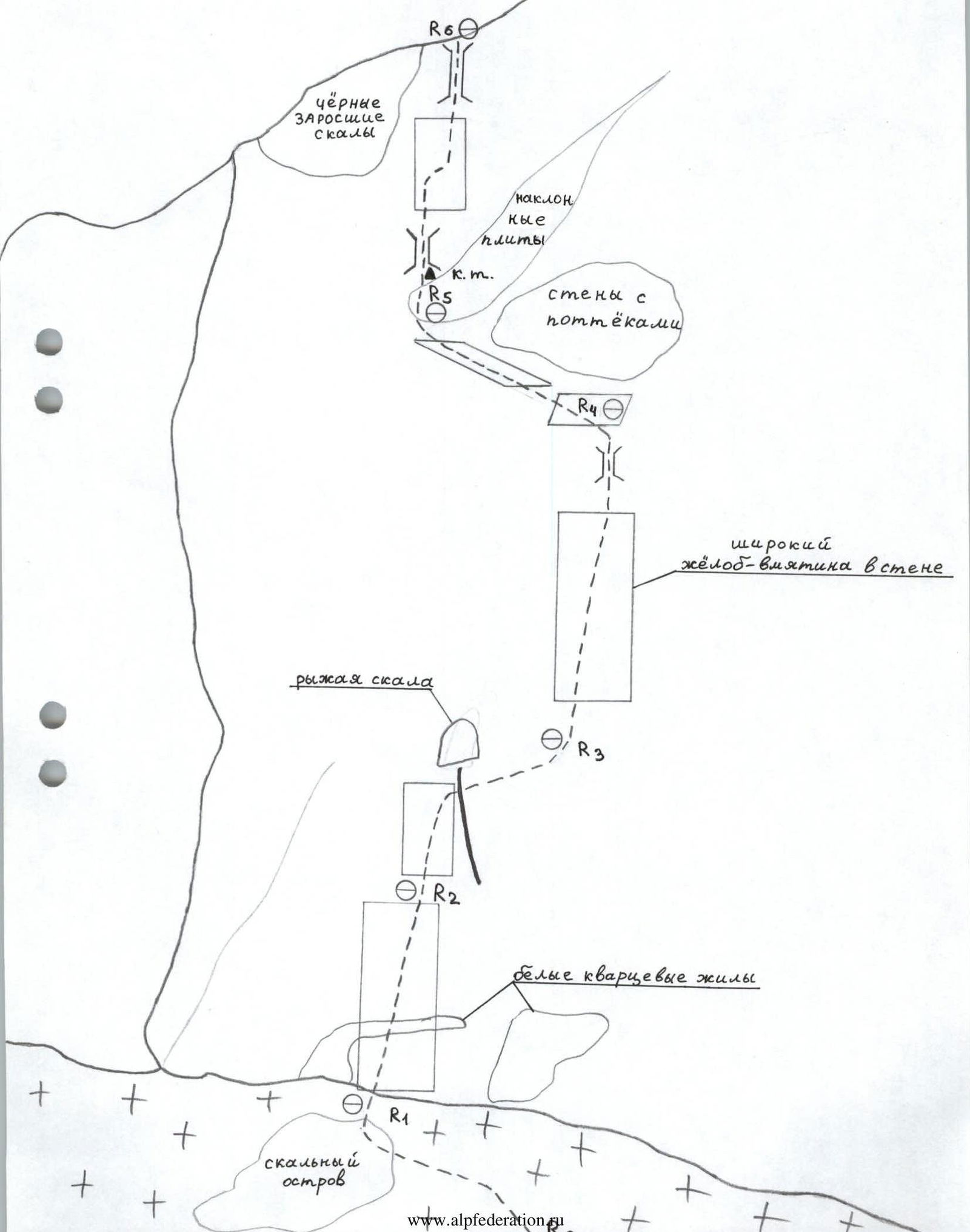
- R0–R1: Reach the rocky outcrop from the right via the firn slope, initially not too steep, then up to 40°. Crampons are necessary. The ascent to the top of the outcrop — traverse left upwards 30 m, 2. At the end of the section — ice, 5 m, 3.
- R1–R2: From the top of the rocky outcrop — via a not clearly defined internal corner through white quartz broken rocks. The further path should be chosen slightly upwards to the right. The section is 2 at the bottom, 3 in the middle and upper parts. The wall's steepness is about 60°. Length 60 m.
- R2–R3: Continue via the wall composed of large blocks with small ledges between them. The direction is upwards to the right, under the base of the rusty rock protruding slightly forward. After 50 m — traverse right through a small ridge. On the traverse — black "live" stones. Further, behind the ridge, enter a wide groove-depression in the center of the North face. The entire section — 60 m, 3, местами 3+.
- R3–R4: Via this groove — straight up. First, via the left part, then via the center, where all difficult sections are bypassed via ledges. This part — 3. Higher — after 80 m — a small chimney, 3+, with "live stones" at the bottom. Via it, reach a wide inclined shelf covered with stones. Above it — sheer smooth walls. The entire section — 90 m, steepness at the bottom — 50°, higher — up to 65°.
- R4–R5: Here it is necessary to move upwards to the left via an inclined rocky terrace-shelf. To the right — walls with black streaks. At the end of the section — exit under the base of inclined slabs leading upwards to the right under the rusty overhanging gendarme. We need to traverse upwards to the left, towards the walls leading to the ridge. The entire section — 60 m, difficulty — местами 3, mainly 3+.
- R5–R6: At the beginning of these walls, near a small chimney-slot on the right — a control cairn on a piton. From it — upwards via walls overgrown with lichen, about 10 m. Then — upwards to the right, towards the visible against the sky wall's bend. The direction of movement — to the right of the black overgrown rocks. After 50 m from the start of the section, approach the base of the chimney, up to this point — 3+, average steepness — 60°. Further — 10 m straight up via the chimney, 4+, up to 85° — and exit onto the wall's bend.
- R6–R7: Continue via traversing the East slope via ledges and through small walls — towards the snowy couloir (route 1B category). Section — 90 m, 1–2.
- R7–R8: Further — via the snowy couloir straight up (crampons). Reaching the rocky saddle, turn left and via the ridge after 50 m — ascend to the summit of Hitsan. The entire section — about 350 m, 1–2, местами 3.
Descent — via the route 1B category.
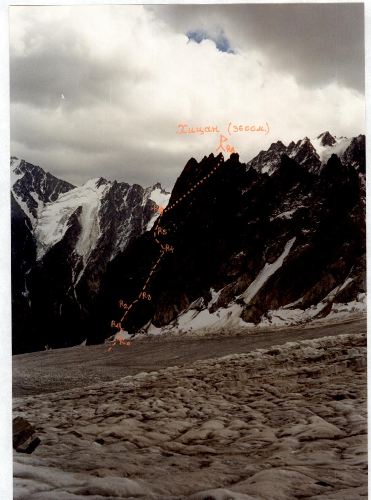
Photo 2. Profile of the wall on the right. September. Photo from the North branch of the Tsey glacier (opposite the peak Nikolaev). The first ascent route is marked.
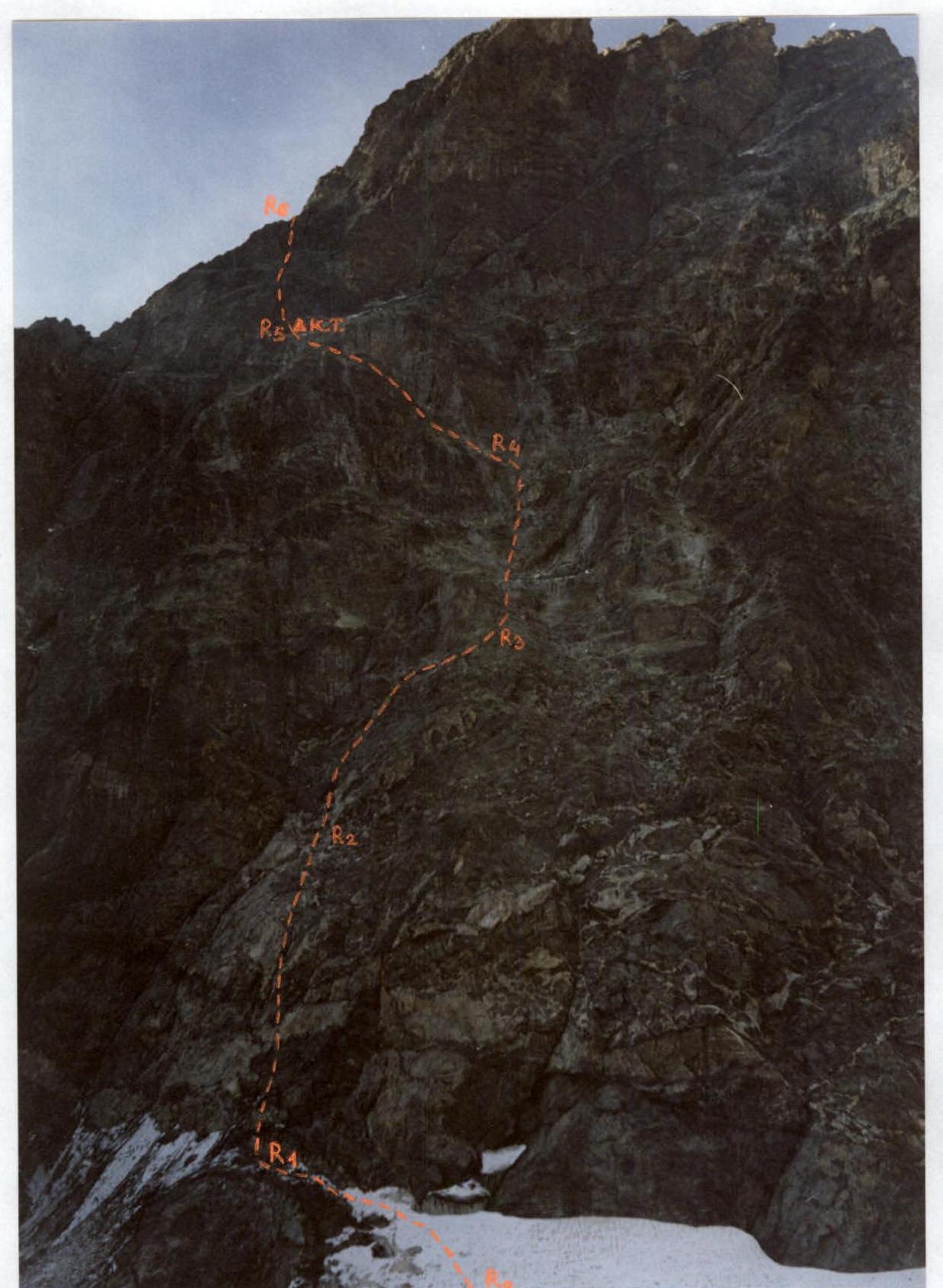
Photo 3. Technical photo of the route. September. Photographed from the glacier, from under the wall.
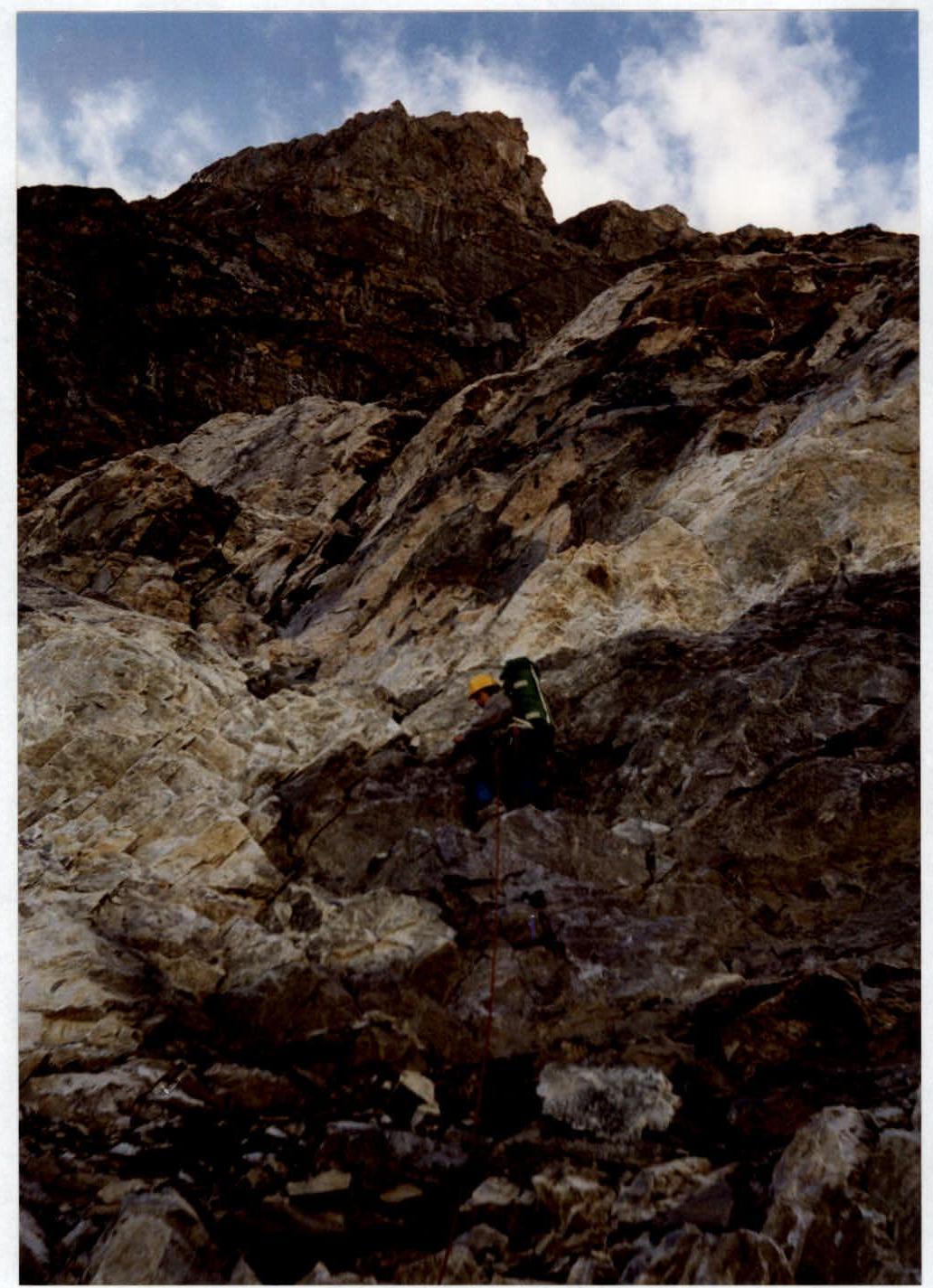
Photo 4. Start of section R1–R2 — via the wall under quartz veins.
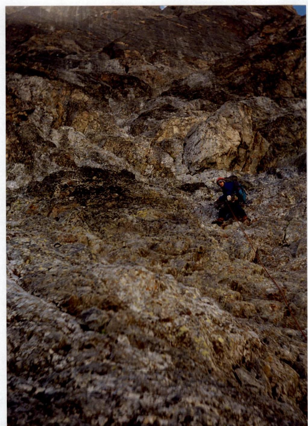
Photo 6. Movement via the groove in the center of the North face. Middle of section R3–R4.


