- Sugan Maly — Uzlovoy (V. Popov's combined route, cat. 5A, fig. 11).
The path from the base camp on the right bank of the Psygansu river (group of 4–8 people) to the initial bivouac on the scree of the wide snow plateau of the Sugan ridge saddle between the peaks Suganbashi on the left and Maly Sugan on the right is described in route 35. From the base camp — 8–10 hours.
The path from the "Nakhashbita" glade to the initial bivouac via the Doppakh pass takes:
- 1–2 days (see routes 17, 22, 26, 28).
From the bivouac, along the snow plateau, bypassing the Southeast ridge of the Central Sugan peak on the right, approach the snowy slope of the wide couloir descending from the upper part of the Southeast ridge of the massif to the plateau.
Overcoming the bergschrund, perform a 200 m ascent, sticking to the rocks, along the steep ice-snow slope (running belay).
Then:
- ascend 40 m along the wet slabs (running belay) to the Southeast ridge of Maly Sugan;
- turn right;
- ascend 160 m along the heavily destroyed rocks of the ridge with numerous gendarmes;
- bypass the last "Klyuv" gendarme;
- reach the base of the summit tower of Maly Sugan.
From here, along a narrow, difficult 18–20 m shelf to the right — up to the summit tower, then:
- straight up the rocks of above-average difficulty, 12–15 m wall or slabs to the saddle of the tower;
- from the saddle, along a simple ridge, exit to the right onto the summit of Maly Sugan.
A bivouac is possible. Descent from the summit along the ascent route to the Southeast ridge.
From the ridge, along a steep inner corner, descend to the left (west) onto a narrow horizontal ledge. Along the intermittent ledge, a difficult traverse to the chip. Behind the chip, after passing 40 m along the ledge, ascend straight up the rocks of above-average difficulty wall to the ridge of the saddle behind the Maly Sugan peak. Along the narrow snow saddle, approach the ascent of the Central peak of the massif.
From the saddle, ascend 80 m along the heavily destroyed rocks of the ridge, then 40 m along the rocks on the right side of the ice slope of the wide couloir. From it, exit to the right onto the rocks, along which ascend to a short cleft in the summit tower. From here, straight up along the difficult 5-meter cleft and 4-meter overhanging rocks to a small platform. From the platform, to the right-up along the 8-meter cleft, 20-meter rocks of above-average difficulty, steep smoothed slab, and sharp ridge — ascent to the summit ridge and along it to the summit of Central Sugan.
A bivouac is possible.
From the Central peak:
- 40 m rappel onto the ridge;
- then along the sharp, gentle 80-meter, and further 40-meter steep icy complex rocky ridge — descent to the saddle.
From the saddle, ascend along the 80–100-meter rocky ridge of average difficulty to the summit of Uzlovoy Sugan.
From Uzlovoy peak, two 40 m rappels onto the wide snow West ridge. The further descent goes along the West ridge with two rappels from the last gendarme to the Sugan-2 pass (see route 39). From the initial bivouac to the Sugan-2 pass — 10–12 hours. The duration of the route is 3 days.
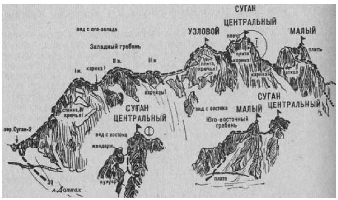
Fig. 11 Naumov A. F. Karaugom, Digoriya, Tsey (Central Caucasus), M., "Fizkultura i sport", 1976.
