
2. Group Composition and Support
The mountaineering group that completed the traverse consisted of athletes with the 1st sports category from the MGS DSO "Trud" gathering, held at the "Bezengi" alpine camp:
- Saratov Yu.S. — group leader,
- Beda A.G.,
- Golubkov B.S.,
- Daruga V.K.
Three of the group members had experience climbing in the Bezengi region in previous seasons. All participants underwent joint training during the pre-camp period and completed training ascents:
- 3B — Ullu-Auz-Bashi
- 4B — Main Jangitaus via the northern edge, category of complexity in the 1964 season.
The group was fully supplied with food for 8 days and had the following equipment:
- "Pamirka" tent — 1 piece,
- Main ropes 12 mm — 2×40 m,
- Auxiliary rope — 40 m,
- Rock pitons — 12 pieces,
- Ice pitons — 8 pieces,
- Carabiners — 12 pieces,
- Rock hammers — 2 pieces,
- Expendable rope — 15 m,
- Down sleeping bags — 4 sets,
- Down suits — 4 sets,
- "Febus" primus stove and 4 liters of gasoline.
For emergency signaling and indicating their location, the group had a flare gun with a supply of flares.
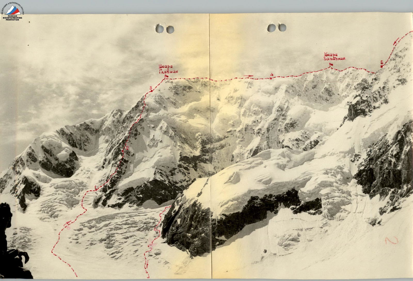
3. Ascent Route Description
Day 1 — July 17, 1964. Departure from the "Bezengi" alpine camp at 5:00. The path follows the trail to Misseskosh, then descends to the Ullu-Chiran glacier (Bezengi), and then along its right (orographic) side to the confluence of the Western and Eastern branches of the glacier. Here, to the right of the stream, the group climbs up to the right-bank moraine of the Eastern branch of the glacier, then continues on the trail to the "Austrian" campsite. The journey from the camp took the group 5 hours and 30 minutes.
At 13:00, after resting, the group continued towards the start of the route. The path initially follows the glacier, bypassing wide crevasses on the left in the area of the base of Shkhara's northern ridge, leading to a broad snow-ice slope descending from the cirque between the northern ridge and the northeastern crest of the peak.
The slope is bounded on the left by:
- an icefall descending from Shkhara's "cushion",
- and on the right by ice falls adjacent to the lower rock outcrops of the northern ridge.
The group:
- ascended 250–300 m up the middle part of the snow-ice slope (using crampons, in rope teams),
- traversed to the right,
- entered a snow-filled depression above the ice falls.
The journey from the "Austrian" campsite took 4 hours. In the depression, under the cover of an ice wall, a bivouac was set up. By 17:00, the weather deteriorated, with rain turning into snow grains.
Day 2 — July 18, 1964. While one rope team dismantles the bivouac, the other processes a 50-meter section of the snow-ice slope, paving the way to the start of a rock ledge on the eastern side of the ridge. The 60–80 m long ledge is traversed with protection via rock pitons (2 pieces) and outcrops, leading to a broad snow-ice slope that transitions into a couloir above.
Due to weather conditions, the extent of the ice sections was not as great as expected (ice and rocks were covered with a sufficient layer of snow), making it simpler to overcome them by cutting steps rather than wearing crampons. This significantly accelerated the team's pace.
After entering the snow-ice couloir, the rope teams continuously interacted and:
- first ascended 50 m straight up along the boundary between rocks and ice, organizing protection via rock outcrops;
- traversed 20 m to the right onto the rocks of a "rock island" located in the middle part of the "necktie";
- ascended 30–40 m up the rocks;
- performed a 40 m traverse to the right through an ice couloir onto the ridge that bounds the couloir on the right.
Protection was provided from the rocks via pitons and ice pitons in the couloir. By 8:00, the group had gathered on the rocks, having safely exited from under the threat of potential rockfall.
150 m up the rocks, and the group emerges under a rock wall — the confluence of all the ridge's counterforts. The lower part of the wall is ice-covered, while the upper part overhangs. This section!
Photo 1: Upper section of the North Ridge of Main Shkhara.
The 20 m long section is traversed with piton protection (4 pitons). Above the wall, a pronounced ridge continues upwards. Since the group reaches the planned campsite — a 300 m ridge plateau above the overhanging wall — early, at 14:00, and there's still daylight left, the movement continues further.
- 80 m up the rocks.
- Then 50 m of a snow slope and up smooth snow-covered rocks — ascent to the yellow rise of the ridge.
- Another 50 m of a snow ridge, abutting the next rise of yellow rocks on the ridge.
- To the left, 3 m below the ridge — a campsite.
Since no further suitable campsites are expected within the next 3–4 hours, the group stops for the night at 15:00. Throughout the day, the weather remained good, but by evening, as usual, clouds enveloped the wall, and it snowed.
Day 3 — July 19, 1964. 4:00. From the campsite, the rope teams alternately proceed along the pre-processed path:
- first 25–30 m up a rock couloir,
- then through a crevice onto a plateau.
To the right of the plateau, there's a 6–8 m ascent via a chimney formed by a rock detached from the ridge. The exit from the chimney is to the left onto a snow-covered smooth inclined slab (piton protection). Further, 30 m along a broad snow ridge to a rock wall, which is bypassed on the left. Another 120–150 m along snow-covered rocks, and the group approaches severely jagged sheer walls. Here, along the slabs below the walls, a traverse to the left is made, onto the left side of the ridge, then along a horizontal ice-filled ledge.
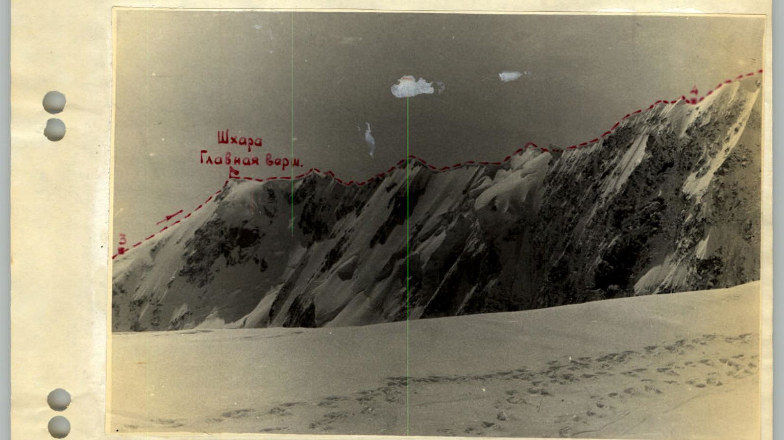
Photo 2: Traverse section from Main to Western Shkhara Peak.
(Pitons, ice had to be chiseled away) — it's necessary to traverse along the eastern face of the wall and ascend 4–5 m up a sloping slab above the ledge. Upwards, an ice-filled rock couloir is traversed with step-cutting:
- first 15 m up,
- then 10 m to the left onto the jagged rocks of the ridge.
This section requires careful movement, as protection in the couloir is challenging — to hammer in rock pitons, one must first find and clear ice from crevices. The sharp rock ridge transitions into a slope with snow-covered rocks, followed by 350–400 m of a rocky ridge with gendarmes.
After passing the rocky section, the group reaches a horizontal arcuate snow saddle 40–50 m long, traversed with careful protection via ice axe. From the saddle, 2–3 meter snow cornices hang to the west.
From the saddle:
- 150 m ascent up a steep slope covered with deep loose snow onto the ridge,
- then 40 m along the ridge,
- another 100–120 m up snow-covered rocks,
- and via an ice gully (10–12 m, pitons) the group reaches the drop-offs of a hanging glacier.
There's still a significant amount of daylight left — 5–6 hours, the sky is overcast, it's cold, and the drop-off is in good condition — it's decided to continue moving.
From the ridge plateau:
- first, ascend upwards,
- then left along a rocky, ice-filled gully between the edge of a rock slab that drops sheer and the ice walls of the drop-off (piton protection).
To the left, the drop-offs are bounded by a rock couloir:
- it's necessary to cross the couloir — 30 m,
- and then ascend from the left side of it upwards — 60–80 m.
The weather deteriorates sharply, heavy snow is falling, but there's still 400–500 m to the potential campsite.
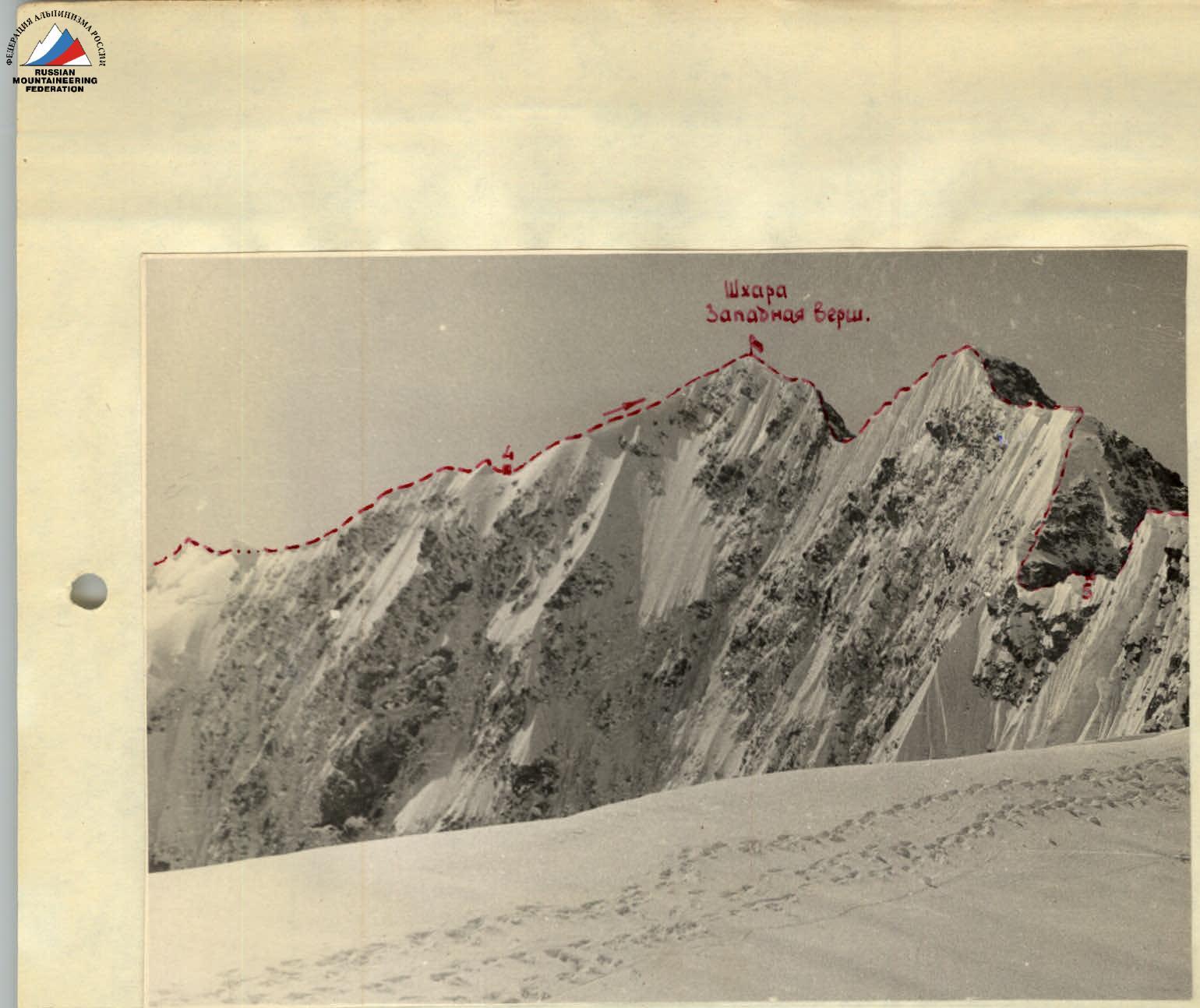
Photo 3: Traverse section from Western Shkhara to the "saw".
The group ascends 150–200 m up a snow slope (deep loose snow), alternating with rock outcrops, and via a rocky couloir ascends onto the snow ridge of a counterfort adjoining the northern ridge on the left. After 80 m, the ridge abuts a snow-firn pre-summit slope. At 17:00, having cut part of the ridge, the group sets up a tent and stops for the night.
Day 4 — July 20, 1964. Departure at 6:00. The weather is clear, and at an altitude of about 5000 m, the temperature is below 0°C. The snow-firn slope is traversed in 2 hours and 30 minutes, and the group reaches the eastern ridge of Main Shkhara, 50 m to the left of the summit. In the valleys on the Svaneti side, clouds lie, and a strong gusty wind blows. From a cairn on rocks south of the summit, a note from a Czechoslovak group that ascended Shkhara via the northern ridge in 1962 is retrieved. Leaving their own note and putting on crampons, the group begins traversing the wall towards Jangitaus. By 11:00, earlier than usual, the weather starts to deteriorate, clouds from the south engulf the wall, it snows, and the wind strengthens. Snow clogs the goggles, visibility sometimes reduces to 20 m, and the lighting conditions make it difficult to control the participants' positions on the ridge. All this significantly hinders the rope teams' movement, but there's no suitable place for a bivouac along the entire ridge section from Main to Western Shkhara, and the group is forced to continue, primarily orienting themselves by the line of cornice break-offs and using continuous ice axe protection. Powerful cornices hanging from the ridge to the north are a characteristic feature of the entire Bezengi Wall.
- On the southern side, their snow surface is mostly glazed to such an extent that movement in crampons is challenging, and steps have to be cut.
- Venturing onto a more gentle part of the cornice is dangerous, as it's usually located above the break-off line.
However, the most challenging sections on this route segment are the sharp ridge sections. Their total length is relatively short (180–200 m), but traversing the knife-edge ridge demands significant psychological strain, particular attention, and careful protection. The task of the lead climber is especially difficult, as they must cautiously, checking each step, tread a narrow path in the loose snow, without being able to lean on the ice axe.
As soon as the group reaches a section of a broad ridge, a decision is made to set up a bivouac. After 2 hours of trampling a platform in the loose snow on the ridge, the group stops for the night at 17:00.
Day 5 — July 21, 1964. During the night, it cleared up, and the morning is clear and windy.
Departing the campsite at 6:00, the rope teams, alternating, continue the traverse. Ascending the snow-firn rise of the ridge, the participants see the Western peak. The descent to the saddle before the peak ends with a sheer ice serac, down which a sporting descent is organized on the saddle (30 m).
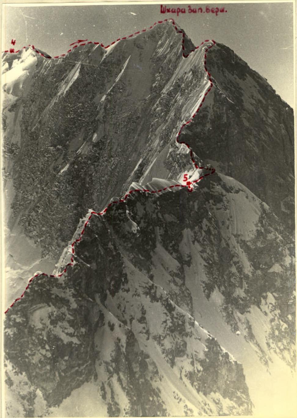
Photo 5: Section of Western Shkhara and the "saw" from the last gendarme of the "saw".
A gentle snow-firn ridge with cornices leads to the peak, with an altitude difference of about 200 m.
Upon exiting the ridge onto the summit tower, it's necessary to overcome:
- a ten-meter section of a steep (up to 70°) ice slope;
- steps;
- pitons.
A note from the LGS DSO "Trud" group that traversed the wall in 1960 is retrieved from the summit.
After descending from the summit:
- a new ascent onto a snow-ice "gendarme" (slightly lower than Western Shkhara);
- followed by 150 m of a snow-ice ridge;
- then a descent of 300 m down a steep snow slope transitioning into a snow-covered rocky ridge.
After a rocky "gendarme", the group descends 25 m from the saddle onto a broad snow plateau lying north of the ridge. Time — 13:00. Clouds from the south engulf the area again, reducing visibility to 30–50 m. The flat plateau is well sheltered from the wind, and the group stops for the night.
Day 6 — July 22, 1964. Departure at 4:00. Ahead lies the "saw" section of Shkhara — rocky, ice- and snow-covered "gendarme" of the ridge. The rope teams move alternately, with protection, typically via outcrops and ice axe.
From the penultimate "gendarme":
- 80 m of steep descent down glazed rocks (sporting);
- further — to the last "gendarme" leads a sharp arcuate ridge with 10–15 meter cornices.
The southern slope of the ridge drops almost sheer, and the snow vertical "leg" of the cornice is so thin that it even просвечивает. There's no way around, and the 10-meter section of the ridge must be traversed very cautiously, as cutting a step could destroy the cornice wall, piercing it through.
The ridge leads into a broad snow-filled depression before the rocks of the last "gendarme" of the saw, which lies already on the northeastern ridge of Sh. Rustaveli Peak. It's traversed head-on. The "gendarme" ends with a sheer rock wall, from which the group descends via a double rope (free rappel) and exits onto a sharp snow-ice saddle.
Leaving their backpacks behind the saddle, the group ascends the northeastern ridge to the summit of Rustaveli Peak. A note from a Georgian Alpine Club group that traversed the wall from Gestola to Shkhara in 1959 is retrieved.
The descent from the summit follows the ascent path, then a traverse of the northern and northeastern slopes of Rustaveli Peak along snow-covered, crath, in places frozen rocks — and the rope teams exit onto a broad plateau between Rustaveli Peak and Eastern Jangitaus.
The snow on the eastern slope of Jangitaus hasn't had time to soften, the group quickly gains altitude, and within 1 hour, ascends 300 m. Only in the upper part of the slope — the last 100 m — does snow give way to ice, but using rocky outcrops and cutting several steps, the group reaches the northeastern ridge.
Leaving their backpacks, within 30 minutes, the rope teams reach the summit — 13:00. A note from the LGS DSO "Trud" group that ascended the peak this year is retrieved.
The descent from the summit down the northeastern ridge begins at 14:00. The initial part of the path is a gentle but sharp snow ridge. The eastern slopes, under the influence of the sun, have softened to a depth of 20 cm, with solid frozen snow beneath, into which the ice axe is hammered with difficulty. Therefore, this section is traversed alternately with continuous ice axe protection.
After the upper campsites (at the point of a sharp ridge bend), a rocky section begins, where the rope teams' movement accelerates, as the heavily jagged ridge with numerous ledges allows simultaneous movement, throwing the rope over the ledges.
The descent into the couloir to the platforms at the start of the eastern counterfort is done sporting — 80 m. At 18:00, due to the onset of darkness, the group halts the descent and stops for the night.
Throughout the entire traverse, the first day — July 22 — the weather was excellent.
Day 7 — July 23, 1964. Departing the bivouac site at 7:00, the group descends to the plateau via the eastern counterfort in 2 hours and 30 minutes, then traverses the icefall under the base of the northeastern ridge and returns to the camp by 13:00.
4. Conclusion
Overall, the traverse of the Bezengi Wall peaks from Shkhara to Jangitaus proceeded according to the developed plan and was completed by the group exactly on schedule. Detailed planning of the ascent route, good physical and technical preparation of the climbers, the correct selection of equipment and supplies ensured that the ascent did not significantly impact the health of the participants, and they returned to the camp in good physical and moral condition.
Group Leader: Saratov