Ascent Passport
- Ascent category — technical.
- Ascent area — Central Caucasus, "Bezengi" alpine camp, Dumala valley, Koshtan-Krest ridge.
- Ascent route — Oktyabrenok peak (3890 m) via the north face (first ascent).
- Characteristics of the ascent:
- route length 1460 m,
- height difference 900 m,
- average slope of the route 60°,
- average slope of wall sections 76°,
- length of difficult sections 610 m.
- Pitons driven:
- rock pitons 157
- ice pitons 7
- Number of climbing days 3
- Number of climbing hours, including processing day, 33
- Number of overnight stays and their characteristics — 2 lying down, platforms prepared
- Team name — LenVO team (instructors from "Bezengi" alpine camp)
- Team composition — SHEVCHENKO YURIY SERGEEVICH, Master of Sports, captain, coach CHEREPOV VLADIMIR ALEKSEEVICH, Candidate for Master of Sports
- Ascent date — July 7–9, 1976.
Sports characteristics of the ascent object.
Despite being remote from the "Bezengi" alpine camp, the upper Dumala valley has been frequently visited by climbers in recent years. The valley offers ascents of varying difficulty. The peaks of the Koshtan-Krest ridge attract the most attention. Exploration of this area and passage of the most challenging routes on the Koshtan-Krest ridge peaks were carried out by teams led by A. Naumov and V. Daruga. In particular, V. Daruga's team first ascended the north faces of p. im. XXII syezda KPSS (control-ascent route, 5B category of difficulty) and p. Pioneer (5B category of difficulty). Our attention was drawn to the north face of p. Oktyabrenok (3890 m) — a peak located between p. im. XXI syezda and p. Pioneer. The 900-meter face, tucked away in the north slope of the Koshtan-Krest ridge and bounded on the left and right by powerful hanging glaciers, looks quite impressive.
The face can be divided into:
- a lower part, dissected by a series of couloirs with walls and individual blocks of rock, covered in ice "Triangular Shield",
- three sheer rock pitches, separated by steep snow-ice slopes,
- a summit rock tower, approached by a narrow ridge with gendarmes.
Even a cursory glance at the face convinces that its passage requires climbers to make difficult and responsible decisions. These include, first and foremost:
- choosing a safe path under the face and exiting onto the lower part of the face, including crossing a couloir with potential ice and rockfall;
- overcoming the sheer, smooth rocks of the central part of the face.
July 6
The day was dedicated to reconnaissance and processing approaches to the face. The pair departed for the ascent from "Green Camps" at 3:30 AM. Although the descent from the moraine to the glacier had been thoroughly examined the previous day, navigating it in the dark was not straightforward. The path along the glacier to the base of the snow-ice slope took about an hour. The ascent through the bergschrund and then on crampons up the steep snow slope (500 m) — approximately 5–6 rope lengths to the right of the rock island, left of the counterfort of p. Pioneer, leading to its shoulder (R0–R1). This is a safe location and a good observation point. From here, 1.5 rope lengths up, to the right of the rock "tongue," exit into a couloir.
Further:
- the next 60 m — easy to moderately difficult rocks (R1–R2);
- the next 80 m — moderately difficult rocks, gradually rising above the couloir by 10–25 m (R2–R3).
Partially used rock ledges. Belaying from the start of entering the couloir was exclusively via pitons and very thorough. Movement along the right wall of the couloir at a height of up to 25 m provides reliable protection from falling rocks and potential icefalls from the left glacier. Protection from falling rocks from the right is provided by the bend of the counterfort of p. Pioneer. It is just beyond this bend that the dangerous section begins, requiring clear and quick work — the transition to the lower part of the face of p. Oktyabrenok.
On the reconnaissance and processing day, the pair worked on the route for 6 hours. The ascent path was processed up to the turn of the right-hand wall of the couloir. 120 m of rope were fixed. 10 pitons were driven.
July 7
Departure from the base camp at 3:00 AM. Approach to the route — 1 hour. Ascent via the previously fixed ropes — 1 hour.
After rounding the counterfort, without losing height, they traversed approximately 15 m to the base of a narrow rock couloir-well, descending from the right down the slope of p. Pioneer. Here, a piton was driven. Further, on crampons, they traversed a 40-meter ice slope. At the end of the couloir, they crossed a 5-meter groove (R3–R4). The steepness of the traverse slopes is up to 60°. Belaying was via pitons. Mainly rock pitons were used, which the team did not remove.
The rocks of the "Triangular Shield" do not have easy sections. The general direction of movement is upwards through the center, then along the right part to bypass the first dissecting gap-couloir from above. After that, along smoothed rock walls and slabs, movement is directed to the left. Here, the upper part of the "shield" is dissected by a second, relatively gentle (45°) snow-ice couloir. On this part of the rock face, approximately 4 rope lengths long, 29 pitons were driven (R4–R5).
From the lower point of the 2nd dissecting couloir, along its right rock part (30 m) — transition to the right side of the face (R5–R6).
From here, two options for further movement are possible:
- 20 m (45°) under the ice overhang (R6–R7), bypassing it on the left via a narrow, very steep (up to 60°) ice couloir between the rocks and serac;
- bypassing the overhang on the right.
The second path, due to hanging ice walls above, appears more dangerous. The pair chose the first option, driving 5 pitons on a 35 m section (R7–R8). The general direction of movement is upwards towards the right rock outcrop. Here, under a 3–4-meter massive rock overhang, a bivouac was set up.
On the same day, the next section was processed — a 60-meter snow slope bypassing the upper part of the "shield" with a 7–10-meter ice section (3 pitons).
On the first day of ascent, the pair worked directly on the route for 13 hours. They covered, counting from the bergschrund, 745 m, and drove 55 pitons (including the processing day).
July 8
Departure from the bivouac at 7:15 AM. Ascent via the previously processed path (R8–R9) — under the first rock pitch. The overall steepness of this pitch is over 75°. Only closer to the left part (R9–R10) is a tolerable beginning visible: a barely expressed smooth internal angle going upwards to the right.
The rocks are steep, smoothed, with insignificant holds, and limited opportunities for piton placement and use of artificial footholds. On the entire 80-meter pitch, the first climber ascended without a backpack (R10–R11). Climbing was complicated by water flowing from upper ledges. Occasionally, icicles and pieces of accretion ice fell from above.
The first pitch, like the even steeper (up to 80°) second (120 m) and third (100 m) pitches of the face, presents very difficult (even for climbing in Vibram shoes without a backpack) rocks, often requiring the use of ladders or étriers, unexpressed internal angles, vertical slabs, monoliths, overhangs, and other forms of relief. Climbing is more challenging than, for example, on F. Zhitenev's route on the Bodhonn wall.
The second pitch was ascended closer to the center, initially along a 10-meter internal angle going left-upwards. An attempt to exit onto the right edge of the pitch was unsuccessful: the rocks here are even more complex.
Through a chain of hanging ice formations, they reached and ascended a steep (50°) 15-meter ice slope under the third pitch (R11–R12). The length of the third pitch is approximately 120 m.
The path on it begins with a difficult 25-meter section, ending in an overhang, after which there is an inclined ledge. From it, the path goes left upwards, bypassing a large outcrop, and further along a steep, wet angle with "live" rocks. A challenging spot. The angle leads under a cornice (overhang 0.8 m), which is climbed on the left part with the help of ladders.
10 m further, there is an inclined ledge facing p. im. XXII syezda, 30 m to the left of the snow-ice ridge (R12–R13). A small platform was constructed here, "Zdarka" at 10:15, with 85 pitons driven. The length of the path on this day was 380 m.
July 9
Departure at 7:30 AM. Ascent onto the ridge — 30 m (R13–R14). Initially, the ridge is snowy, well-defined, but approximately after one rope length, it is interrupted by complex rock gendarmes-cubes for climbing, so the pair had to deviate left again onto a accretion ice slope (R14–R15) with individual rock outcrops (40 m) and further overcome an 70–80-meter wall of complex rocks (R15–R16), partially using artificial footholds.
For approximately 15 m, the first climber ascended without a backpack. The wall has "live" slabs. The wall ends with an exit onto the summit tower.
At this point, there is a powerful triangular recess in the massif, bounded by planes. Along a slab, ascent to the "triangle's" apex (R16–R17) and further along a 7–8-meter sheer wall (without a backpack) — exit onto the ridge (R17–R18).
An attempt to continue along the rock ridge was unsuccessful: the rocks are smoothed, without cracks, and there are almost no belay points when overcoming the gap between gendarmes.
Along accretion ice (25 m), the pair moved along the rocks to the right (R18–R19) onto a snowy pre-summit slope, along which (3 rope lengths) they ascended to the summit of p. Oktyabrenok (R19–R20).
Up to the summit ascent, excluding the snow slope where simultaneous movement is possible, belaying was exclusively via pitons (24 pieces). The ascent to the summit took 4 hours. The total length of the section was 315 m.
The descent path from the summit went east along the Koshtan-Krest ridge to Koshtan Pass and further to the base camp at "Green Camps." The descent took about 6 hours.

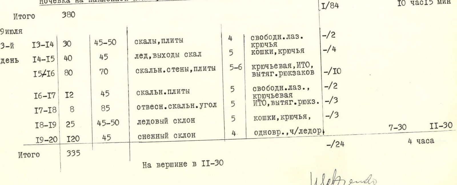
TABLE of main characteristics of the route to p. Oktyabrenok (3890 m) via the north face
- Height difference — 900 m
- Route length — 1460 m, including most difficult sections — 610 m
- Average steepness — 60° (most difficult sections — 76°)
| Date | Section | Length in meters | Average steepness in degrees | Characteristics of sections and passage conditions | Category of difficulty | Method of movement and belaying | Pitons driven ice/rock | Departure | Stop |
|---|---|---|---|---|---|---|---|---|---|
| July 6, 1976. Route processing | R0–R1 | 240 | 50 | Snow-ice | 4 | Crampons, alternating | -/1 | ||
| R1–R2 | 120 | 50 | Rock | 4 | Free climbing | -/4 | |||
| R2–R3 | 80 | 60 | Rock | 4 | Alternating, piton | -/5 | 5:30 | 11:30 | |
| Total | 440 | -/10 | 6 hours | ||||||
| July 7, 1st day of ascent | Passage of processed sections R0–R3 | ||||||||
| R3–R4 | 60 | 55 | Rocks, ice | 5 | Crampons, steps | 2/4 | |||
| R4–R5 | 160 | 65–75 | Rock walls, ice, ledges | 5 | Climbing, Aids, pitons, rope pulls | -/29 | |||
| R5–R6 | 30 | 50 | Rock edge, couloir | 4 | Free climbing, piton | -/3 | |||
| R6–R7 | 20 | 45 | Snow-ice slope | 5 | Crampons, pitons | 2/- | |||
| R7–R8 | 35 | 60–50 | Ice couloir | 5 | — "ttt-" — | 2/3 | 4:00 | 17:00 | |
| Bivouac under a rock overhang on snow | |||||||||
| Total | 305 | 6/39 | 13 hours | ||||||
| July 8, 2nd day | R8–R9 | 60 | 50–55 | Snow-ice, rock outcrops | 4 | Crampons, pitons | 1/2 | ||
| R9–R10 | 20 | 45 | Snow | 4 | Traverse under the wall | -/1 | |||
| R10–R11 | 80 | 75–80 | Rock pitch | 5 | Piton, Aids, rope pulls | -/21 | |||
| R11–R12 | 120 | 75–85 | Rock pitch | 6 | Piton, Aids, rope pulls | -/32 | |||
| R12–R13 | 100–120 | 70–75 | Rock pitch | 5 | Piton, Aids, rope pulls | -/28 | |||
| Bivouac on an inclined ledge, preparation of platform — 1 hour | 7:15 | 17:30 | |||||||
| Total | 380 | 1/84 | 10 h 15 min | ||||||
| July 9, 3rd day | R13–R14 | 30 | 45–50 | Rocks, slabs | 4 | Free climbing, piton | -/2 | ||
| R14–R15 | 40 | 45 | Ice, rock outcrops | 5 | Crampons, pitons | -/4 | |||
| R15–R16 | 80 | 70 | Rock walls, slabs | 5 | Piton, Aids, rope pulls | -/10 | |||
| R16–R17 | 12 | 45 | Rock slabs | 5 | Free climbing, piton | -/2 | |||
| R17–R18 | 8 | 85 | Sheer rock angle | 5 | Aids, rope pulls | -/3 | |||
| R18–R19 | 25 | 45–50 | Ice slope | 5 | Crampons, pitons | -/3 | |||
| R19–R20 | 120 | 45 | Snow slope | 4 | Simultaneous, via ice axe | 7:30 | 11:30 | ||
| Total | 335 | -/24 | 4 hours | ||||||
| At the summit at 11:30 |
Assessment of the difficulty of the route ascended
The technical complexity of the route, the considerable length of extremely difficult sections (over 690 m) requiring specific experience and high endurance for their passage, undoubtedly allow it to be classified as the highest — 5B category of difficulty.
The route has practically no convenient and safe bivouac sites, except for those where the pair bivouacked in the "Zdarsky" tent.
At the same time, the first ascenders consider it necessary to warn that the path along the north face of p. Oktyabrenok will likely be challenging even for masterful groups.
Passing the route requires:
- special tactical experience;
- choice of optimal time of year;
- clear and quick work by climbers.
Particular attention must be paid to crossing the right couloir and ascending the lower part of the rock "triangular shield."
Otherwise, considering the potential for collapse of the hanging glaciers between which the face of p. Oktyabrenok is sandwiched, climbers may find themselves in an emergency situation.
List of main equipment (for a pair)
- Main rope 60 m
- Auxiliary rope 10 m
- Vibram boots 2 pairs
- 2-step ladders 4 pieces
- Crampons — 2 pairs
- "Zdarsky" tent
- Ice pitons, mainly tubular — 5 pieces
- Rock pitons in set — 15 pieces
- Hammers — 2 pieces
- "Vitalka" radio station
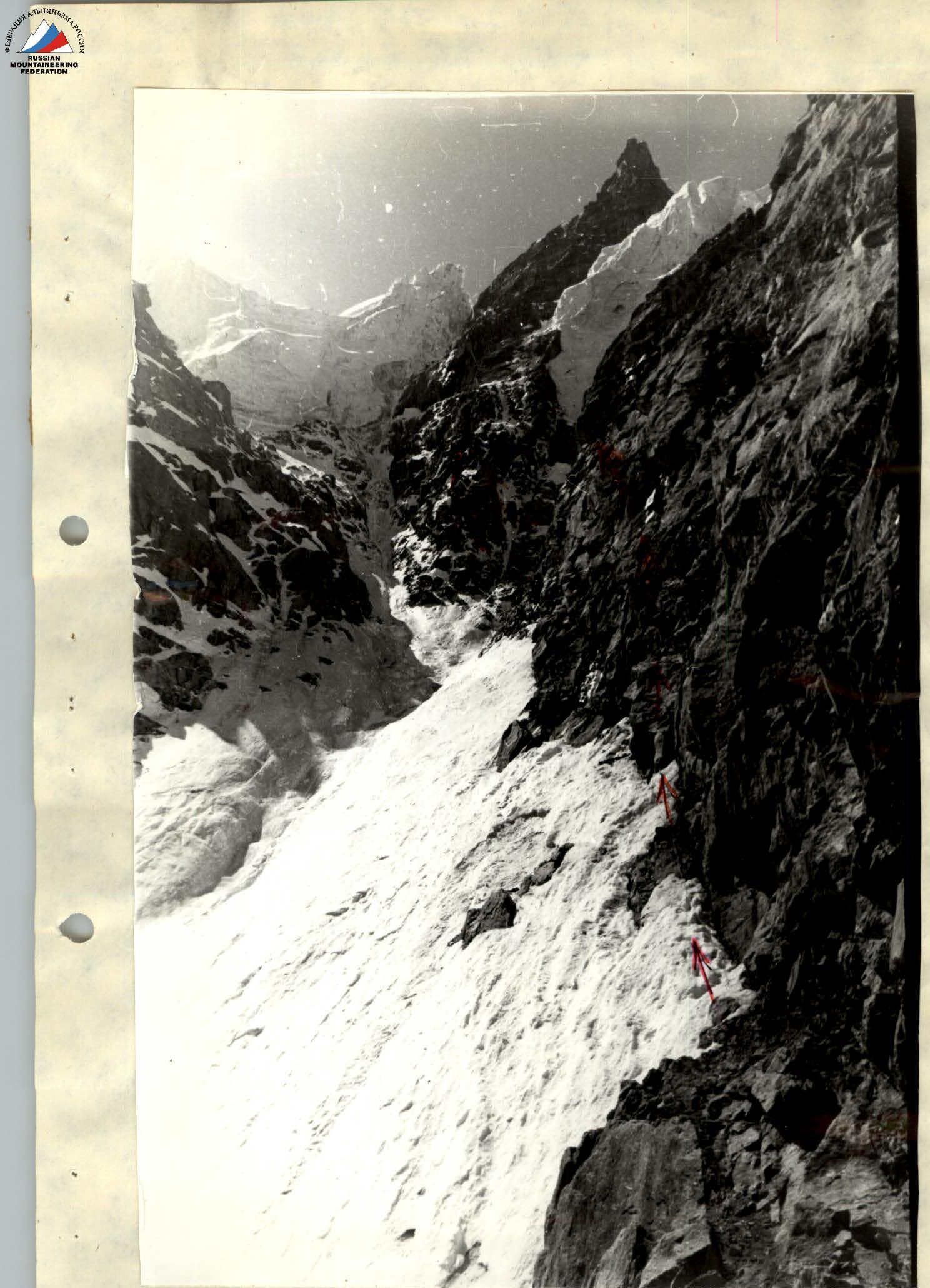
Sections R1–R2, R2–R3. Partly visible is the transition to the face and the lower part of the "triangular shield."