Ascent Description
TO THE SUMMIT OF V. MIZHIRGI VIA THE N. RIDGE. Completed by the MGS DSO "Trud" gathering group. July 27 – August 1, 1962.
The Mizhirgi peak (5027 m) is located in the Bezengi region of the Central Caucasus, at the center of one of the most complex ridges — Koshtan-Tau — Dykh-Tau. The north ridge ascending to the eastern summit of Mizhirgi from the Cheget-Mizhirgi glacier was first climbed by a Pelevin group in 1952.
The ridge drops off towards Krumkol with a vertical rock wall, and towards Dykh-Tau with steep and avalanche-prone slopes. In the lower third, its steepness is around 70°, the remaining part is an icy ridge (40–60°) with several steps in the form of rock cliffs. The key sections of the route are the ridge exit and the pre-summit wall. The route is classified as 5B category difficulty.
The MGS DSO "Trud" gathering group completed this ascent from July 28 to 31, 1962, with the following team members:
Cheremisov V. 1st sports category — leader Tkachenko A. 1st sports category — participant Petiforov V. 1st sports category — participant Daruga V. 2nd sports category — participant
Ascent Description
Day 1. On July 27, the group departed from the "Bezengi" alpine camp and ascended to the 1st stage of the icefall. Here, under the slopes of Mizhirgi on the right moraine, a bivouac was set up, and the day was spent observing the most hazardous sections and the overall state of the route.
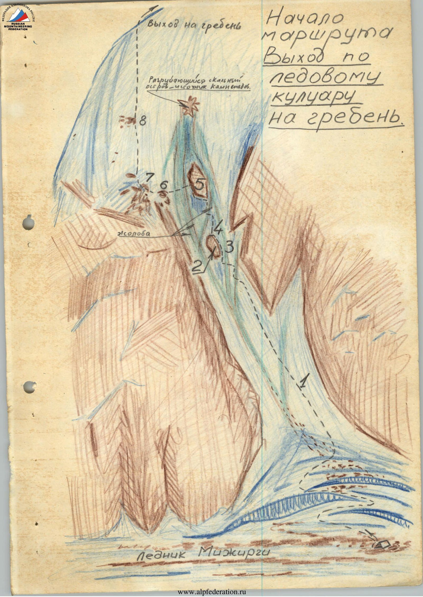
The firn-snow cover had melted off the entire ridge, the lower half of the route was pure ice, and all steep areas were exposed above. The pre-summit wall featured a vertical ice drop in the middle and giant icicles that periodically fell, showering the base of the wall. Rock steps were местами covered with ice. However, the lower part of the route proved to be the most hazardous: the exit to the ridge via an icy gully with two rock "islands." From 9:00 to 10:00 AM until 8:00–9:00 PM, the gully and the couloirs beneath it were swept by powerful rockfalls. Only from 1:00 AM to 8:00–9:00 AM was this section safe to traverse (later found to be safe until 7:00 AM). Thus, the 400 m section with a steepness of 60°–70° had to be traversed with step-cutting and ice axe placements within 6–7 hours.
At 0:30 AM, the group set out on the route with lanterns (the night was warm and foggy, rockfalls ceased only by 1:00 AM). The lower couloir R1 was initially firn-covered, allowing for quick passage of the first 2 ropes (steepness 30°–40°, length 3 ropes). However, in its upper part, several icy gullies had to be crossed, and steps had to be cut. The exit from the couloir under the first rock "island" R2 was via a wide icy gully (0.5 ropes); step-cutting and axe placements were required in the water flow. Behind it, another, equally wide gully descended, and between them, a narrow wedge of porous ice ascended (1 rope) towards the right edge of the "island." Steepness was 60°. The section was traversed on front points, beak, and axe with piton belay. Just short of the "island," the wedge ended and transitioned into a 70° ice wall on the right-hand bypass R3. Here, 1 rope of step-cutting and handholds with frequent piton placements was required. Fortunately, it was already dawn, allowing for an increased work pace. The group reached the "roof" of the "island" R4 (a slab protruding from the ice; it was also steep on top, with no place to rest). The gully between the "islands" — partly porous, partly hard ice — widened and, at the top (2.5 ropes), overhung the 2nd rock "island" R5 with shattered rocks from rock impacts and dust patches. Higher up, closer to the ridge, the source of rockfalls was visible — a nest of rock talus already touched by the sun's rays (6:00 AM). The slope was traversed with piton belay, alternating between front points and step-cutting. Invisible small stones started to whistle by (initially small, not visible from below). The group hastily reached the shelter of the "island's" rocks, hammering in rock pitons, and began to traverse left along the edge (1 rope; the edge was low but provided cover). The ice steepness increased again to 60°–70°. The group approached the upper corner of the "island" and organized a traverse (1 rope) onto the "ram's foreheads" R6 of the slope leading to the ridge. Here, intense bombardment occurred, requiring utmost caution and speed. Belay was on ice and rock pitons. On the other side, the group moved behind the "ram's foreheads" and ascended via the ice between them towards a large rock "island" R7 on the left, above the wall of the ridge's drop-off. A sitting platform was found here — the group rested and had breakfast. It was 9:00 AM, and the first rockfall from above occurred (some rocks were up to a meter in diameter). However, the group was already out of the bombardment zone. Above them, an icy slope ascended to the ridge. The group moved towards a solitary "islet" R8 mid-slope. Steepness was 60°, местами 70°. Again, steps, handholds, and pitons were required. By 11:00 AM, 4 ropes were traversed when a thunderstorm began, and wet sleet started falling. The group moved during brief calm periods, otherwise hanging on pitons. At 4:00 PM, the storm subsided, and the group traversed another 3 ropes, reaching the ridge by 7:00 PM. The ridge led to the first rock wall-step with a broad, gentle slope. No better bivouac site was visible ahead, and the team was soaked through. They set up a bivouac under the wall (at 8:00 PM).
Day 2. The ascent began at 6:00 AM. Attempts were made to dry off slightly, and at 7:00 AM, the group continued on the route. They quickly approached the wall R9. A traverse to the right via a crevice behind the wall's corner and up a cleft, short chimneys with slabs (70°), led to the ridge (1.5 ropes). The ridge continued upwards as a sharp icy crest (40°). The group moved above the rock outcrops. Step-cutting and front-pointing, with belay via rock outcrops, were used. They approached the second step, wider R10. Initially, a vertical wall (0.5 ropes) was climbed, then a ledge and several chimneys on the right (0.5 ropes), and via a vertical cleft, an exit (1 rope) was made onto a small platform, from which non-steep rocks and slabs led to the ridge. After the 2nd step, the ridge's character changed: a steep icy crest with nearly vertical rises, a wall dropping off on the left, and rock "feathers" protruding at the top. The crest was occasionally interrupted by short walls and slabs with ice cover. Sometimes slabs were hidden under 1–2 cm of ice. By 11:00 AM, they reached a large rise of the icy crest. Passage via the rock-ice junction was not feasible here. The group moved along the sharp crest with cornices, cutting steps on the side or chopping off the crest (3 ropes). Further, the 3rd step — steep slabs (2 ropes), steepness 40°, with an ice crust on top R11 — required searching for cracks for pitons, chopping through the crust. Weather deteriorated, and another thunderstorm began (at 2:00 PM). After traversing a bit more along the ridge, a depression was found, and a platform was cut out. The group decided to wait it out; however, the sleet ceased only by 6:00 PM. Ahead lay the 4th step with iced-over slabs. The group stayed for the night.
Day 3. At 6:00 AM, the ascent to the fourth step R12 (2 ropes) began.
Further movement was as follows:
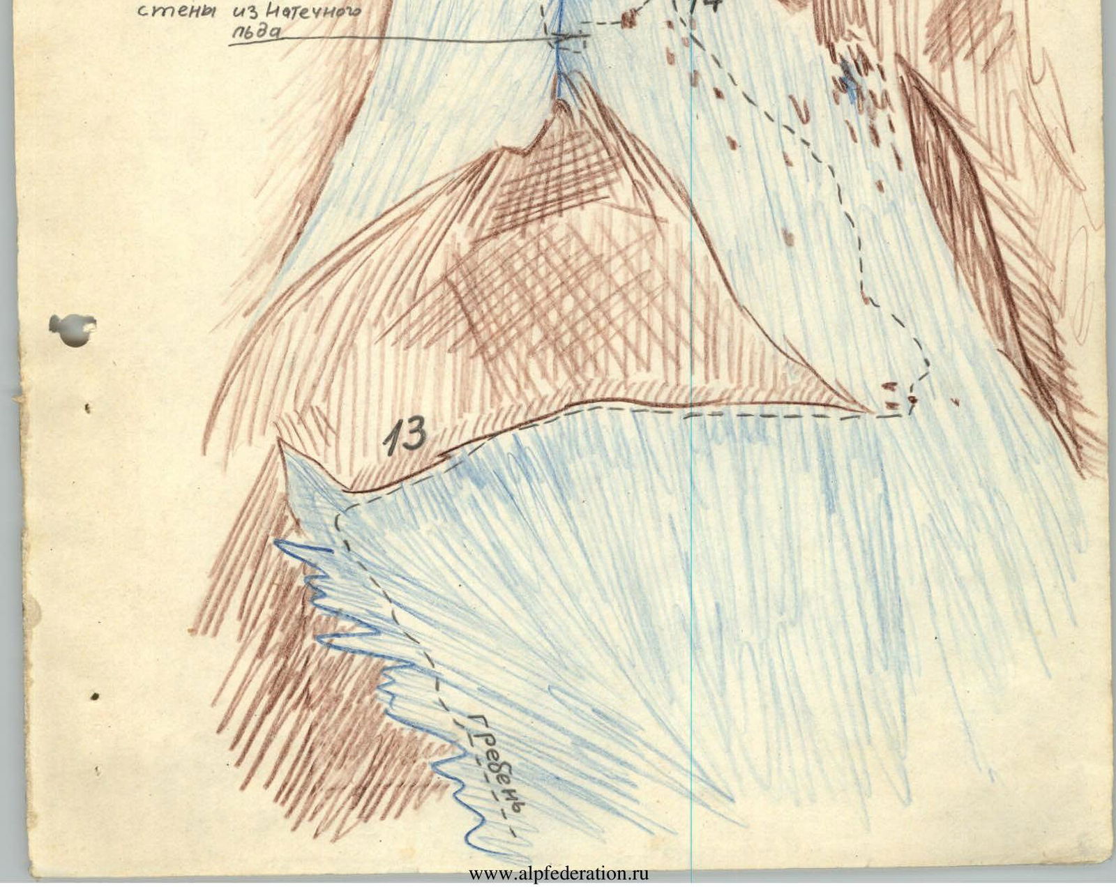
- along the icy crest (150 m) to the "rooster" (a large feather of the wall);
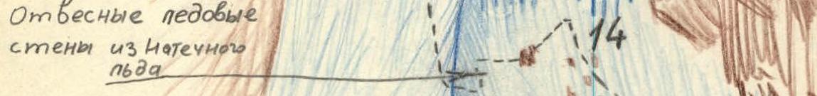
- along the ice-rock junction — under the pre-summit wall R13 — 150 m.
From the junction of the crest and the wall, the group traversed along the wall (rock pitons and steps in ice) for 3 ropes and, bypassing the wall's ridge on the right, exited into a wide, iced-over couloir steeply ascending to the wall under a "room" with giant icicles. Here, step-cutting and searching for the thickest ice layer for pitons were necessary. Icicles continuously broke off from above, but there was no place to take cover. 2 ropes of ascent under the icicles required 2 hours of work. Weather deteriorated again. The group entered the "room" R14. To the right and above, an icy vertical wall dropped off, with a "roof" above it that they needed to reach. They began traversing the wall in its lower part, cutting out:
- a narrow ledge (7–8 cm);
- handholds;
- pitons every 2–3 meters.
Then, a 2-meter rappel down from a piton and again:
- a ledge;
- handholds;
- pitons — for another 5 meters of traverse to the wall's turn. The left slope was more gentle, but further on was a rock wall, and it was already 7:00 PM. The group set up a sitting bivouac on the wall's ledge.
Day 4. The ascent began at 6:00 AM, and at 7:00 AM, they continued. Under the rocks, they ascended to the right-upwards (2–2.5 ropes) to the upper part of the ice, where a vertical rock chimney R15 ascended. A traverse under it to the wall on the right (0.5 ropes) and an exit onto a destroyed, inclined ledge (solid "live" rocks) followed.
Further on the wall:
- a vertical cleft (1 rope);
- a short chimney with an overhanging exit.
Here, careful piton belay and complex chimney climbing with stemming were required. The group exited onto a slope above the wall. Steepness was no more than 40°, decreasing further up. Initially, two ropes of movement were on ice between slabs; further, the slope of the pre-summit dome was traversed.
Here, firm firn appeared, and after 3–4 ropes, step-cutting and belaying via ice axe were possible. Steepness decreased to 30°, and under the dome itself, the group exited again onto the ridge.
Further:
- a traverse to the right upwards along the dome's slope;
- an exit onto the plateau — flat!
The summit was ahead. From the plateau, the icy crest to the summit was steep, and on the left, it was a destroyed rock ridge. The group traversed from the icy to the rock ridge and via cracks and chimneys (3 ropes) reached the summit (at 2:00 PM).
From the summit, a descent was made onto the saddle between the E. and W. peaks, and by traversing a destroyed ledge, bypassing the Western summit, the group exited onto the ridge descending from Sella Pass. Here, several ropes to the right of the ridge along the slope, then an exit onto the ridge, and a 30-meter rappel (a section of 5A category difficulty) brought them to the "Black Rocks" bivouac (by 5:00 PM).
Day 5. From early morning, a blizzard and strong wind. Visibility was no more than 30–40 m. A 20-meter rappel was made from the ridge to the right onto iced-over slabs, followed by 5 sports ropes to a couloir, and along it, alongside walls, another 7 sports ropes down to Sella Pass (by 2:00 PM). By 5:00 PM, the group descended through the icefall to the "Austrian bivouacs" under the slopes of Semenovsky Peak and by 9:00 PM was back at the camp.
The two-kilometer route to V. Mizhirgi via the N. ridge is one of the most challenging routes in the Caucasus. In favorable conditions — presence of firn, good weather (usually climbed in July) — it can be completed in 3–4 days. By early August, the route's condition significantly deteriorates; however, it remains accessible and is technically much more interesting.
Bezengi — Moscow. 1962.
Photographs and drawings of the most challenging sections of the route.
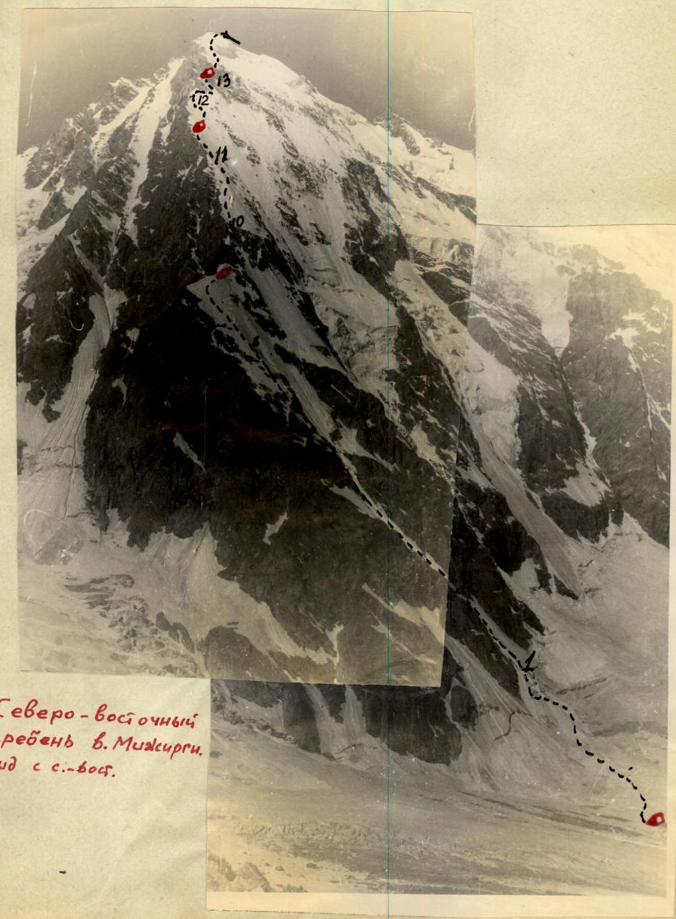 The north-eastern ridge of V. Mizhirgi. View from the N.E.