
Climbing Passport
- Climbing area: Central Caucasus, Lateral Ridge, Krumkol glacier gorge. Section number according to KMGV: 2.5
- Peak: Koshtantau 5151 m, via the Southwest slope.
- Difficulty category: 4B, 3rd ascent *.
- Route type: ice and snow.
- Height difference: approximately 1400 m.
- Route length: approximately 2 km, including 50 m of ice sections with a steepness of 50–55°, 500 m with a steepness of 40–45°; 750 m of snow and ice sections with a steepness of 30–40°.
- Number of pitons used (during ascent): ice screws - 39.
- Number of climbing hours to the summit - 16, reaching the summit on the second day of ascent (11:00), descent via the ascent route - 11 hours.
- Number of bivouacs - 2 (1 on the ascent route and 1 on the descent, at the same location).
- Team composition:
| Full Name | Qualification |
|---|---|
| Anisimov N. B. | 1st sports category |
| Sedelnikov E. | CMS |
| Kaluzhsky S. N. | 1st sports category |
| Kolchinskaya E. E. | 2nd sports category |
- Team coach: Shibaev S. A., CMS.
- Entering the route - July 25, 2004, at 5:00 (from the upper cirque of the Krumkol glacier), reaching the summit - July 26, 2004, at 11:00, returning to the base camp - July 27, 2004 (to the moraine of the Krumkol glacier).
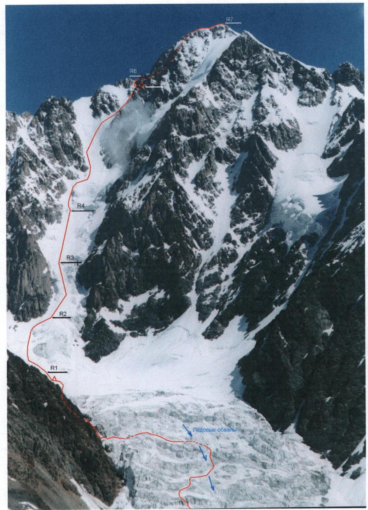
Fig. 1. Route thread and division into sections
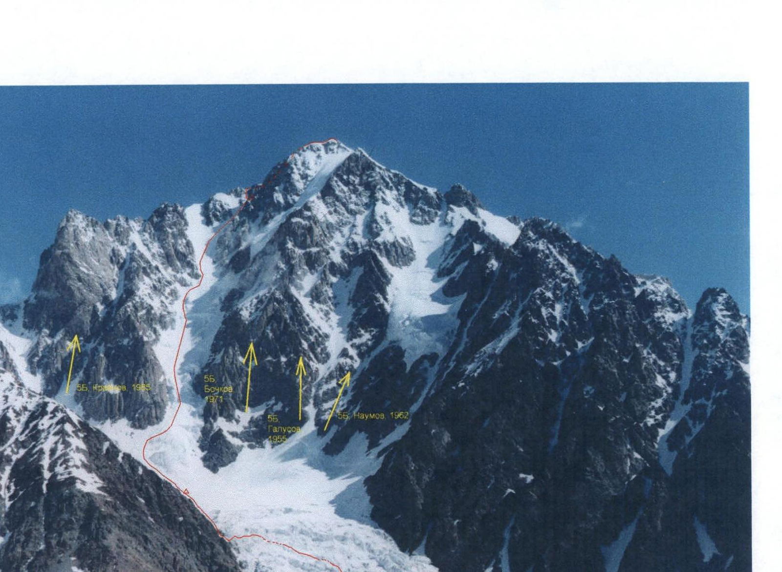
Fig. 2. General view of Koshtantau from the south
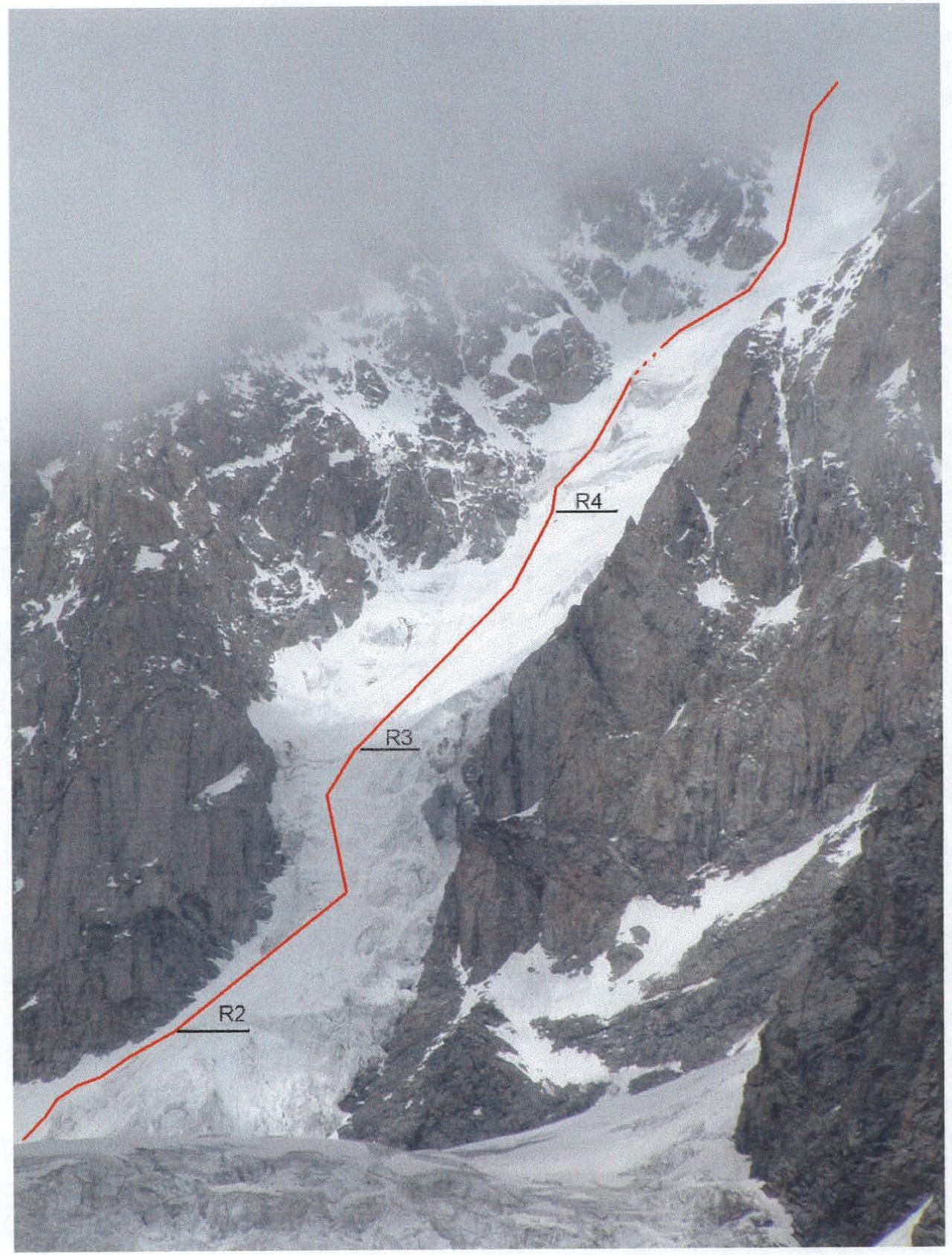
Fig. 3. View of the lower part of the route in semi-profile
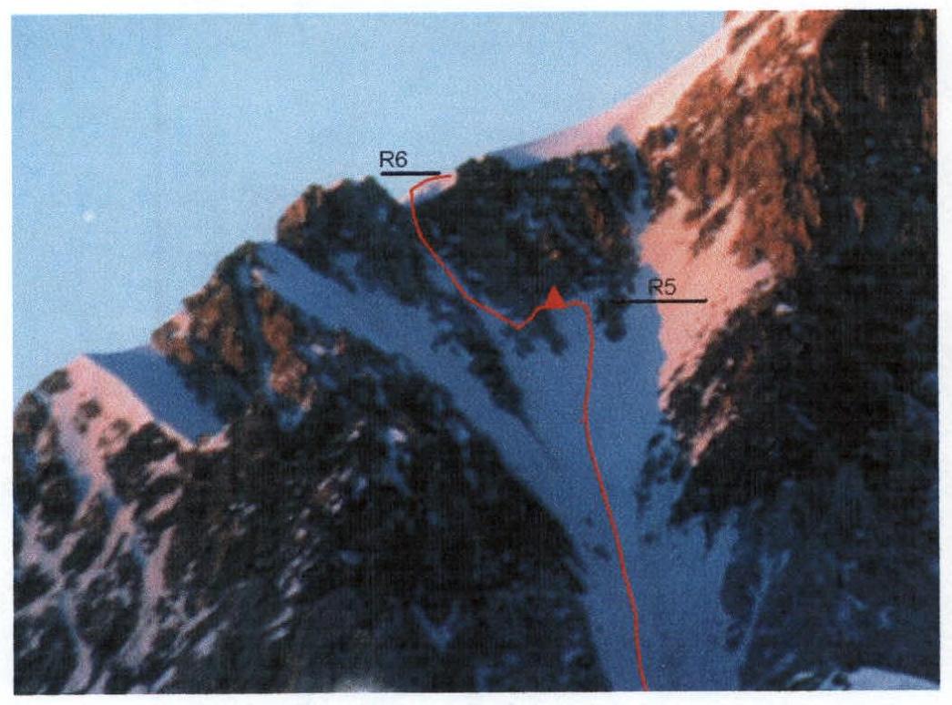
Fig. 4. Upper part of the SW couloir and bivouac site
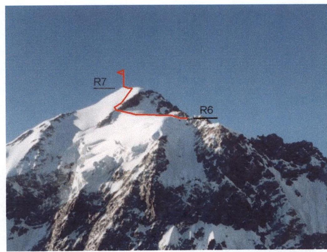
Fig. 5. View of Koshtantau from the NW and upper part of the route
Climbing Area Map
(Extract from the map "Scheme of mutual arrangement of peaks and passes of the Greater Caucasus. K-38-27-v. Bezengi Glacier")

Magnetic declination east 5° 39′ Geographical basis. VTU GS USSR Ministry of Defense 1966–1970
Scheme compilation, field survey. V. G. Lyapin 2003
The scheme is made on the basis of and with the accuracy of a 1:100,000 scale topographic map. Updates, clarifications, and additions were made using:
- Landsat7 and MK-4 satellite imagery,
- Aster and SRTM radar sounding data,
- a tourist scheme published in 1993.
Additional information was added based on materials from tourist and mountaineering expeditions and events. Glacier numbers are given according to the "Catalog of Glaciers of the USSR" published in 1967–1977. Partially surveyed in the field in 2000–2003.
Fig. 6. Route scheme in UIAA symbols
| Section # | Designation | Difficulty Category | Length, m | Relief character and steepness | Ice screws |
|---|---|---|---|---|---|
| R6–R7 | 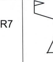 | 2 3 1 | 100 m 150 m 250 m | Snow-ice ridge; Ice, 40°; Snowy plateau | 1 6 |
| R5–R6 |  | 4 2 | 60 m 40 m | Ice, 45°; Ice, rocks, traverse | 4 1 |
| R4–R5 | 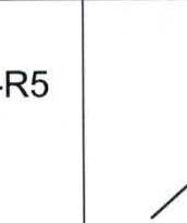 | 4 3 | 400 m 250 m | Ice, 40–45°; Snow, ice 35–40° | 12 5 |
| R3–R4 | 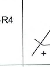 | 2 | 250 m | Snow-ice slope, 30° | |
| R2–R3 |  | 4–3 | 50–80 m | Ice, 55–60°; Ice, 40–45° | 7 3 |
| R1–R2 |  | 2 | 250 m | Snow-ice slope, 25–30° |
Brief description of the route
Base camp - start of the route
The route description is given from the base camp on the moraine under the SE ridge of the Krumkol peak. It takes 2-3 days to reach the base camp from the Bezengi alpine base:
- Along the Bezengi glacier
- Past the Dzhangi-kosh hut
- Through the Kamnepadny pass
- Through the Spartak pass
- Down the Krumkol glacier (right branch) to its confluence with the left branch
From the base camp, descend from the moraine to the left (orographically) branch of the Krumkol glacier and approach the icefall through its middle. The icefall has a not clearly defined winding couloir (with a stream) that collects debris from nearby seracs.
Enter the icefall to the left (in the direction of movement) of this "couloir". After ascending about 200 m through the icefall steps to a high ice wall:
- move right across the conditional line of the "couloir" to a more even slope and ascend another 200 m;
- then move to the left side of the "couloir" above the middle belt of seracs and traverse left to a snowfield between the icefall and the rocks;
- exit to the upper cirque of the glacier via snowfields.
On the glacier plateau - bivouac. From the moraine camp 2–2.5 hours.
Section R1–R2: Bypass of the lower ice rise
The lower part of the glacier flowing down the SW slope (couloir) and abruptly breaking off into the upper cirque of the Krumkol glacier is bypassed on the left via a snow-ice slope with a steepness of about 30°.
Initially, 100 m up a snowy slope to a bergschrund, partially filled with snow. Then:
- 120 m up and right along the ice-snow slope - exit to the glacier above the rise.
- Further 30 m up to a bergschrund, behind which the ice begins.
It is advisable to start this section before dawn, and it can be traversed with headlamps. Movement is simultaneous, without being tied together, in crampons.
Section R2–R3: Second ice rise
Movement in rope teams, alternately, with belays using ice screws. 80 m up an ice slope with a steepness of 45° to the beginning of a steeper section. Further 50 m up ice with a steepness of 50–60° to the top of the rise. On the last section, interaction between rope teams is advisable:
- via ice screws
- via fixed ropes
This is the steepest section of the route. However, the ice is not solid, and the section is uneven. Periodically, there are gentle ledges.
Section R3–R4: Ice-snow slope
Between the second and third rises, the glacier is closed, fairly even, with a steepness of approximately 30° and a length of about 250 m.
- In the lower part of this section, there is a deep bergschrund with bridges made of avalanche snow.
- Movement is simultaneous.
- When crossing the bergschrund - alternately.
Section R4–R5: Third ice rise and upper part of the SW couloir
The third ice rise can be traversed centrally or bypassed on the left between the rocks and a large, gentle ice serac.
Passing centrally is potentially hazardous due to ice falls from the SE plateau glacier hanging above on the right, which are difficult to predict.
Bypassing on the left is hazardous due to rockfalls from the left rocky slopes, which are regularly observed after 10:00 when the sun illuminates the left side of the couloir. Thus, it is advisable to pass this narrow passage between the serac and the rocks before 10:00, both upwards and downwards.
150 m up to the left of the serac on ice with a steepness of 40–45° and to the right - exit to a snowy slope above the serac. Further 100 m to the right and up a snowy slope of 30–35° - exit to the upper part of the couloir.
Further up the ice-snow couloir with a steepness of 40–45°, 400 m up and to the right under the last pinnacle on the ridge between the Tikhonov peak and Koshtantau. Movement is simultaneous, with belays using ice screws. The ice is solid.
Exit to the NW snowy plateau via an ice couloir before the last pinnacle on the ridge. On the ridge, on the northern side, there is a snowy depression convenient for a bivouac. However, on the ridge, there is almost always a strong wind in the evening and at night, and the depression only slightly mitigates the conditions. A more convenient, wind-protected area is located directly under the last pinnacle (see Fig. 4).
On the platform under the pinnacle - bivouac. From the start of the route 10 hours.
Section R5–R6: Exit to the ridge
From the bivouac site, move left and down along ledges and traverse left, a total of about 40 m, to an ice couloir. Up the couloir with a steepness of 45° - 60 m to the ridge. Movement is alternate, with belays using ice screws. The ice is solid.
Section R6–R7: Snowy plateau and pre-summit slope
From the exit point to the ridge, about 250 m along the snowy plateau to the lower left corner of the pre-summit rocks, where via an ice bridge - exit to the northern snow-ice slope of the peak. Along the snow-ice slope, with a steepness of about 40°, with belays using ice screws, 150 m to the summit snow-ice ridge. Along the ridge to the left about 100 m to the summit.
Time taken:
- From the bivouac site: 3–4 hours
- From the exit point to the ridge: 2–3 hours
A cairn with a note on the rocks to the south of the summit.
Descent
Option 1: via the ascent route.
Considering the rockfall hazard in the SW couloir, it is advisable to traverse the upper half before 10:00. Based on this, on the day of the summit ascent, the group descended to the tent on the platform under the pinnacle and stayed overnight. The next day:
- Descent through the couloir to the glacier - about 6 hours.
- Further through the icefall to the base camp on the moraine under the SE ridge of the Krumkol peak - 2 hours.
Option 2: descent via the NE ridge - this is the classic descent route from Koshtantau. With this plan, it is better to organize a bivouac on the NW snowy plateau, which is closer to the summit. On the day of the summit ascent, the group descends via the NE ridge at least to the platform in the area of the Ptitsa peak or to the upper cirque of the Mizhirgi glacier.
Footnotes
-
- Information about the first ascent is given in the book by A. F. Naumov "Central Caucasus", FiS, 1967 - Krobat and Shpanraft, September 1, 1935; the second ascent is confirmed by a note we found - a group of tourists from the "Strelets" club, St. Petersburg, led by K. Gолубев, August 14, 2003, during a 6B category hike.