Ascent Passport
I. Ascent category: technical (wall). 2. Ascent area: Main Caucasus Range from the south, area of Semi pass – Tsanner pass. 3. Ascent route: Tikhtengen, South summit 4611 m via the South-East wall. 4. Ascent characteristics: height difference to the summit 1000 m, wall height difference 900 m, average slope of the entire route 65°, average slope of the wall proper 70°, length of complex sections 560 m (including very complex ones 370 m) 5. Pitons driven: rock — 116, ice — 4, ladder usage — 11 times 6. Number of walking hours: processing 140 m — 3 hours. 1st day — 13 hours, 2nd day — 11 hours, 3rd day — 12 hours, descent — 14 hours 7. Number of bivouacs and their characteristics: Plateau 3600 m — on snow 1st on the wall — sitting on a ledge, 4000 m 2nd on the wall — semi-reclining, outcrop with snow, 4250 m 3rd on the summit — on a snowy ridge, 4611 m 4th on the descent ridge — sitting, on a ledge 8. Team name: team of a/l "Bezengi", CS DSO "Trud". 9. Full name of the team leader, participants, and their qualification: Daruga V.K. — CMS, team leader Karabash B.A. — CMS Rodin E.P. — CMS Kurachenko Yu.A. — 1st sports category 10. Team coach: Daruga V.K.
II. Dates of departure and return:
July 24, 1976 — departure from a/l "Bezengi" July 25, 1976 — base camp and route processing July 26, 1976 — departure on the route July 28, 1976 — reaching the summit July 30, 1976 — return to the base camp July 31, 1976 — return to a/l "Bezengi"
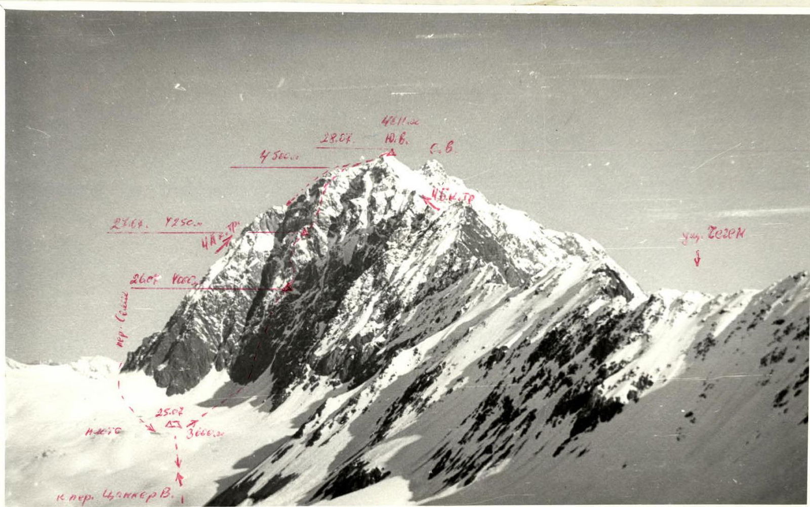
Fig. 1. South-East wall of Tikhtengen. Taken from V. Tsanner pass 3950 m, July 24, 1976.
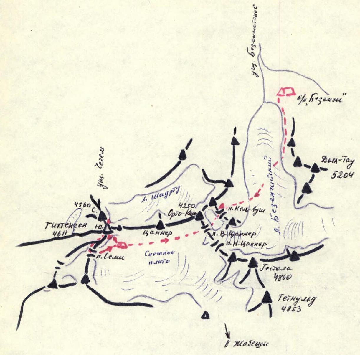
Map-scheme of the area Bezengi–Tikhtengen — — — route of movement Δ Δ — camps and overnight stays
I. Geographical location, ascent conditions
The Tikhtengen summit is a powerful local massif of the Main Caucasus Range, blocking the Chegem valley from the south. To the east of Tikhtengen, a rather low ridge stretches through the Tsanner peak to the Orto-Kara summit, from which the Bezengi area begins. Despite the fact that quite popular trekking routes through the passes (Tiber, Semi, Tsanner) pass around Tikhtengen, its summit is rarely visited by climbers. The following routes have been laid to the summit:
- 4A category of difficulty from the Semi pass along the South ridge
- 4B category of difficulty along the East ridge from the Chegem valley
- 4B category of difficulty along the West ridge
- 5A category of complexity along the North-West wall
- 4A category of complexity along the North ridge
- 5B category of complexity along the North-East wall
The last passage of the North-East wall, 5B category of complexity, was made by a team from Kabardino-Balkaria in 1974.
On the South-East side of Tikhtengen, there is a huge snowy plateau through which the path from the Semi pass to the Tsanner pass and further down to Jabeishi in Georgia passes. Above the plateau rises the South-East wall with three black faces. The central face of the wall looks the most powerful and cohesive, being the steepest and least destroyed despite its southern orientation. The central face of the wall leads 200 m to the left of the summit to the bend of the South ridge. The left face is shorter and closer to the ridge, the right face is less interesting and also rockfall-prone. The central face of the wall was chosen for the first ascent.
Given the significant remoteness of the South-East wall of Tikhtengen from a/l "Bezengi", the ascent acquires an expeditionary character to some extent. To approach the wall, it is necessary to overcome two passes: the Kель-Aush pass (3600 m) and the Upper Tsanner pass (3950 m) (with significant ascent and descent). The approach to the wall from the Tsanner pass through the snowy plateau is especially difficult in conditions of heavy snow cover and warm weather. This year, powerful snowfalls created a deep layer of fresh snow, so even an early start did not save from exhausting work on trampling the trail.
Weather conditions in this area are quite complex. Characteristic features include:
- Continuous, very strong, and gusty southerly wind around the clock.
- Very frequent dense fogs, covering the wall up to a height of 4500 m for the whole day and creating a risk of losing orientation.
3. Route description
Departure from a/l "Bezengi" at 10:00. Ascent via the Bezengi glacier and Baran-Kosh to the Kель-Aush pass (3600 m). Total 8 hours. Overnight stay here.
Further:
- Across the snowy plateau and ascent to the Upper Tsanner pass (3950 m)
- Descent from the pass to the snowy plateau
- Across the plateau along the Orto-Kara — Tikhtengen ridge towards the South-East wall
Total 6 hours. Base camp under the wall on the snowy plateau.
From the base camp to the snow slope under the wall (1 hour) towards the dark gray rock "paw" at the right edge of the central part of the wall.
- Snow slope to the lower bergschrund (40 m, 30°).
- The slope turns into a snow cone cut by a bergschrund. Steepness (40°, 20 m).
- Crossing the bergschrund via a bridge on the right and further up to the second bergschrund — another 20 m, 45°.
- The second bergschrund is crossed via a weak bridge, and then 40 m of a steep snowy ascent (50°) to the center of the rock "paw".
- Exit to the left onto the left spur of the "paw" via a destroyed ledge (20 m, 45°) under a gray overhanging block.
- Circumventing the block from the left via an internal angle (3 m, 60°) and to the right behind the overhanging block via a sheer chimney (rocks! icing! 5 m) — exit above the block.
- Along a ledge 4 m to the right under the second overhang and via an internal angle with subsequent traverse under the overhanging part of the wall (ladder, 4 m) — exit onto a ledge and after 2 meters onto a scree ledge. From it 5 m up the wall — with steps (60°) to the rusty smoothed slabs, along them 10 m and traverse to the left via a sheer 2 m wall onto an oblique simple ledge leading 20 m to the left-up under the walls of the "rusty barrier", a chain of walls going straight up.
From here, 20 m up under the barrier via internal angles and walls (70–80°) — exit onto the barrier at its lowering (apparent from below) onto a wide ledge. From the ledge up 10 m, a wall with steps (60°) onto a ledge-slot (clogged with stones) under an overhang. To the right 3 m to the end of the ledge and onto a sheer wall via a narrow ledge 2 meters. The ledge rests against a smooth vertical internal angle, up it 4 m (ladder) onto a narrow ledge, and from it exit onto the roof of the wall. From here, a stepped wall (10 m, 60°) up towards a large chip before the wall-shell (like an overhanging concave shell). From the chip, traverse to the left 5 m to the sheer left wall with an overhanging top and a detached "feather" in front of it. Via the "feather", exit 4 m under the convexity-overhang. Further 2 m of negative slope (ladder) and exit onto a ledge under a yellow wall in the form of a convex "lens". From the ledge, traverse to the left-up, circumventing the convexity of the wall, into an internal angle (10 m, 60°), leading to the left of the wall into a steep couloir (destroyed! 20 m, 50°). From the couloir to the right onto a wall (5 m, 70°) above the wall-lens, and exit onto a large inclined ledge-roof. Here is the first control point.
Further 40 m up gray steps-slabs, ledges (60–65°) and onto a ledge (40°) with an ice lens on it (it is possible to carve out a sitting bivouac). Along the edge of the ice lens along the wall to the left-up, exit above the lens into a sheer internal angle (water! ladder, 3 m) and to the left onto a ledge covered with a second snow-ice lens (40°). Up onto the top of the lens along the junction of ice and rocks, and from here via a 3 m wall into an overhanging internal angle (water! ladder), and from it to the right onto a sheer wall 5 m (last 2 m overhang, ladder) and exit further onto a gray wall with steps (10 m, 70°), and behind it onto a ledge. From here up gray ("rusty") walls 30 m, exit to the left of the overhanging "rusty" wall to a sheer chimney with ice (icicles! 4 m, ladder, smooth walls, movement in expansion). At the top of the chimney, there is an ice plug; exit to the left-up along a smooth wall 3.5 meters and exit onto a slope with snow above the chimney (40°, possible sitting bivouac). Above, the "rusty fence" of walls-shells and feathers overhangs (visible against the sky). Movement traverse to the right-up along destroyed ledges (rocks! 50°) to the right lowering of the "fence". Through the lowering to the left-up along a steep couloir (60°) with destroyed rocks, then along destroyed walls to the right, and further to the left-up-right under the overhanging tops of the walls (40 m). From here, the middle ascent of the wall becomes visible. Along very destroyed slabs (40 m, 50°) under a gray rock-wall with a horizontal ledge under it. Here is the second control point. Further to the left from the gray rock into a wide couloir (60–70°) with slabs, to the left-up, traverse along the angle and up the slabs 10 m to a destroyed wall (60°). Along it up-left under a brown low overhanging wall onto a destroyed ledge 0.5 m wide. Here we organize a sitting bivouac.
From the bivouac 40 m to the right-up along a non-obvious angle and walls (60–65°) in the direction of the left part of the middle ascent of the wall. Exit into an internal angle with smooth walls (70°), above it a funnel (50°), and further a wall (70°) leads to a small ledge. To the left, a groove passes, above it an overhanging wall with icicles. Traverse of the groove (60°) to the left onto the sheer opposite board and along the wall with niches 10 m up, further wall (65°) to the left onto a protruding slope (complex extraction of backpacks with pendulum and extension). From here 40 m to the right-up, slabs with niches (60–70°) go, above them an internal angle (70°) leading into a sheer chimney with a chip on the board at the top. Behind the chip — a ledge under an overhanging wall, a cut of the ascent. Backpacks are pulled up onto it (live rocks!). From the ledge, descend into the chimney again by 2 meters and move to the left board. Along the niche of the sheer (ladders), exit onto the top of a rock pillar (stones on top!), from it traverse 4 m along a sheer wall (small footholds, repels) to a ledge behind the turn of the wall. From here along the wall 70° up 20 m to a narrow shelf (water!). After the wall — traverse along wet 70–80° steps-walls to the right-up under a large wall (left cut) and in the direction of the edge of the cut to the right-up, with a traverse to the edge along a sheer concave wall 5 m (icy rocks, ladder). Exit onto the edge onto an icy ledge.
To the right of the edge along an icy ledge 5 m and up a 60° couloir with ice, further along a 10 m wall 70° and to its right edge (sheer above the snowy start of the couloir). Immediately behind the edge up-left onto the edge of the cut (slabs like "ram's foreheads", no cracks!). Further, a sharp steep snowy ridge on an ice foundation follows. Under the ridge along its right slope (ice pitons) — exit to the destroyed base of a rusty rock 20 meters to the right of the continuation of the edge of the cut. Along the right board of the snowy-icy couloir going up (50–60°) 1 rope up and sharply to the right — exit onto a large ledge with snow. Here is the place for the 2nd overnight stay (on 2/3 of the tent, the site is built from snow and stones).
From the bivouac up along a wall and a destroyed steep rock couloir, 1 rope leads to a sharp icy ridge before the next cut of the ascent. Cross it to the right and under the wall 70°. Along the wall up-right under an overhang, further traverse up-right along the overhang to the overhanging part. Here 3 m sheer internal angle and traverse from it along the wall to the right 2 m to a sheer icy chimney with a plug at the top. Along the chimney 5 m (ladders) we exit onto the ridge of the cut — a wide ridge 45°, along it up and to the right to a rock couloir to the right of the new ascent of the wall. Along the couloir 1 rope along the left board (50°, wet ice) and further to the left along the wall 60° 1 rope — exit onto a large ridge (rock "foreheads", snow, ice). The ridge 40 m (40°) rests against a wall of a sheer rusty cut. The wall is passed head-on 30 m, and at the top, immediately to the left, to the beginning of a snowy ridge (ice from below). Along the ridge (50°) 1 rope to a rusty "bald head" standing at the left edge of a black large overhang. From here 40 m traverse to the right-up along ledges of the black overhang (70–80°) into the opening of its right edge. From the opening along the wall 3 m (sheer, ladder) up and to the right-up (70°) 40 m — exit above the black overhang. Further along the slope of the ridge (60–50°) to the right-up 40 m — exit onto the South ridge of Tikhtengen through a 10 m wall in the area of two rusty "gendarmerie" on the South ridge.
Further to the right along the South ridge 2 hours to the South summit. The ridge is very sharp, in some places blocked by "gendarmerie" with difficult passage, between them snowy ridges with cornices (above! insurance only by falling in different directions!). Snow is fresh, loose. Overnight stay a little below the South summit (near the landmark) towards the North summit. At the summit at 18:00.
Descent along the ascent path to the junction of the wall and the ridge, further along the South ridge, which goes down more steeply (ridge is sharp, "gendarmerie") to the right. After a hollow — a sheer wall (rappel 30 m), then the ridge widens and after the junction with the South-West spur breaks down into a wall. Descent via rappel 40 m and traverse to the left 10 m along the course back onto the ridge into a hollow. Ascent along simple rocks onto an ascent and descent steeply down to an edge going to the Semi pass. From the edge to the right along a long snowy couloir 200 m onto a slope between the South and South-West branches, and further through a bergschrund — exit onto a snowy trail under the Semi pass from the west. Descent took 14 hours in conditions of heavy snow cover and dense fog (with an overnight stay on a ledge under the start of the couloir).
Through the Semi pass, exit to the base camp 1.5 hours. From the base camp through the Upper Tsanner pass and Kель-Aush pass to a/l "Bezengi" — 8 hours.
Conclusion: The route along the South-East wall to the South summit of Tikhtengen undoubtedly belongs to the technically complex wall category 5B. Despite its southern orientation, the wall is quite weakly destroyed, the route is objectively safe, but requires accuracy during movement. The route is characterized by the distribution of very complex but not extensive sections (sheers) along the entire wall. The route requires very clear tactics and orientation when choosing a path. Technically and in terms of steepness, the route is stronger than the one on the North-East wall.
TABLE OF CHARACTERISTICS OF THE ROUTE ALONG THE SOUTH-EAST WALL OF TIKHTENGEN
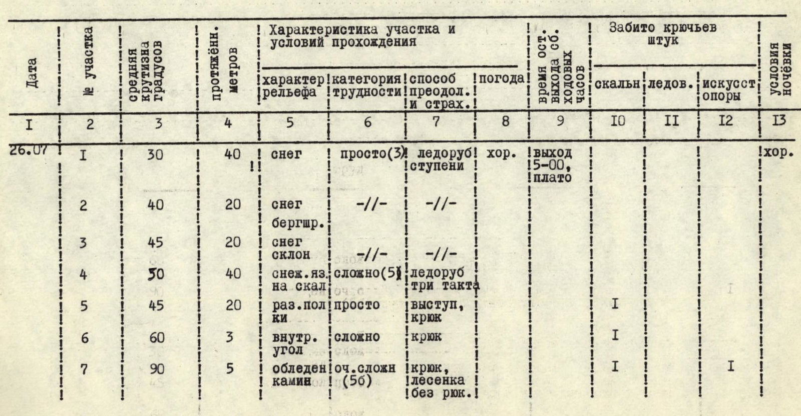
| I | 2 | 3 | 4 | 5 | 6 | 7 | 8 | 9 | 10 | 11 | 12 | 13 |
|---|---|---|---|---|---|---|---|---|---|---|---|---|
| July 26, 1976 | 1 | 30 | 40 m | snow | easy (3) | ice axe, steps | good | departure 15:00, plateau | good | |||
| 2 | 40 | 20 m | snow, bergschrund | – | – | |||||||
| 3 | 45 | 20 m | snow, slope | – | – | |||||||
| 4 | 50 | 40 m | snowy ascent onto a rock | complex (5) | ice axe, three paces | |||||||
| 5 | 45 | 20 m | destroyed ledges | easy | ledge, piton | |||||||
| 6 | 60 | 3 m | internal angle | complex | piton | 1 | ||||||
| 7 | 90 | 5 m | icy chimney | very complex (5) | piton, ladder, without backpack | 2 | 1 | |||||
| 8 | 45 | 4 m | ledge | easy | traverse | |||||||
| 9 | >90 | 6 m | sheer with overhang | very complex | piton, ladder, without backpack | 2 | 1 | |||||
| 10 | 60 | 7 m | ledge and wall | average (4) | piton | 1 | ||||||
| 11 | 60–70 | 12 m | slabs and wall, niche | complex | piton | 1 | ||||||
| 12 | 50 | 20 m | oblique ledge, chimney | easy | traverse, piton | 1 | ||||||
| 13 | 70–80 | 20 m | walls and angles, niches | complex | piton | 2 | 1 | |||||
| 14 | 60 | 10 m | walls-steps | average | – | 1 | ||||||
| 15 | 90 | 5 m | sheer, ledge | complex | – | 1 | ||||||
| 16 | 90 | 6 m | internal smooth angle | very complex | without backpack, piton, ladder | 5 | 2 | 1 | ||||
| 17 | 60 | 15 m | walls-steps, chip | average | piton, ledge, traverse | 1 | ||||||
| 18 | >90 | 8 m | sheer, overhangs "feather" | very complex | without backpack, piton, ladder | 2 | 2 | 1 | ||||
| 19 | 60 | 35 m | internal angle, couloir, and wall | complex | piton | 2 | ||||||
| 20 | 60–65 | 40 m | walls-slab, water | complex | piton | 2 | ||||||
| 21 | 60–65 | 35 m | walls, ice | complex | piton, along ice lens | 2 | ||||||
| 22 | 90 | 5 m | internal angle, water | very complex | above lens, piton, ladder | 1 | 1 | |||||
| 23 | 50 | 20 m | junction of rocks and ice | average | piton | 1 | ||||||
| 24 | 90 | 10 m | internal angle with overhang and water | very complex | piton, ladder | 3 | 1 | |||||
| 25 | 70 | 10 m | walls-steps | complex | piton | 1 | ||||||
| 26 | 65–70 | 30 m | walls-step "rusty rocks" | – | – | 2 | ||||||
| 27 | 90 | 10 m | chimney with ice, smooth | very complex | without backpack, piton, ladder | 3 | 1 | |||||
| 28 | 50 | 40 m | destroyed rocks, stones! | average | traverse, piton, ledge | 1 | ||||||
| 29 | 60 | 40 m | couloir and wall, stones! | – | piton, ledge | 1 | ||||||
| 30 | 45–50 | 40 m | fragile rocks, gray rock | – | ledge | |||||||
| 31 | 60–70 | 30 m | couloir and internal angle, slabs | complex | piton | 2 | ||||||
| 32 | 70 | 10 m | wall and destroyed ledge | – | – | 8:00 overnight stay | 1 | |||||
| July 27, 1976 | 33 | 60–65 | 40 m | non-obvious angle and walls, icy slabs | complex | piton | good | departure 7:00 | 3 | |||
| 34 | 70 | 10 m | internal angle, slabs | very complex | – | 2 | ||||||
| 35 | 50 | 10 m | slabs, funnel | complex | – | 1 | ||||||
| 36 | 70 | 10 m | wall, ledge | complex | – | 2 | ||||||
| 37 | 60 | 15 m | groove, rocks, ice, slabs | very complex | traverse, without backpack | 3 | ||||||
| 38 | 90 | 10 m | wall, niche | very complex | without backpack | 2 | ||||||
| 39 | 65 | 15 m | wall-slope | complex | piton | 2 | ||||||
| 40 | 60–65 | 30 m | slabs, niches | complex | without backpack | 3 | ||||||
| 41 | 70–90 | 10 m | internal angle, chimney | very complex | – | 2 | ||||||
| 42 | 90 | 4 m | sheer, niche | very complex (6) | without backpack, piton, ladder | 2 | 1 | |||||
| 43 | >90 | 4 m | wall, overhang | – | without backpack | 2 | ||||||
| 44 | 70 | 20 m | wall, ledge | very complex | piton | 3 | ||||||
| 45 | 70–80 | 30 m | wet walls, steps | – | piton, with traverse | 11 | 4 | |||||
| 46 | 90 | 10 m | icy wall | very complex (6) | piton, ladder, traverse | 2 | 1 | |||||
| 47 | 50 | 5 m | icy ledge | complex | piton | 1 | ||||||
| 48 | 60 | 15 m | couloir, ice, snow | – | – | 1 | ||||||
| 49 | 70 | 10 m | wall | complex | – | 1 | ||||||
| 50 | 90 | 10 m | sheer above couloir | complex | piton, traverse | 1 | ||||||
| 51 | 70–60 | 40 m | slabs-"foreheads" without cracks! | very complex | piton, caution! | 1 | ||||||
| 52 | 45–50 | 40 m | ice, slope of the ridge | complex | piton | 18:00 overnight stay | 2 | semi-reclining on a ledge on snow, average | ||||
| 53 | 50–60 | 40 m | couloir, snow, ice | – | along the board | 3 | ||||||
| July 28, 1976 | 54 | 60 | 40 m | rocky couloir destroyed | average | piton, ledge | good | departure 6:00 | 2 | |||
| 55 | 70 | 30 m | wall | very complex | traverse, piton | 4 | ||||||
| 56 | 90 | 10 m | wall, sheer angle | very complex (6) | without backpack, traverse, piton | 3 | ||||||
| 57 | 90 | 5 m | icy sheer chimney with plug | – | without backpack, piton, ladder | 2 | 2 | |||||
| 58 | 45 | 30 m | ridge, rocks, ice | average | piton | 2 | ||||||
| 59 | 50 | 30 m | couloir, wet ice | complex | piton | 3 | ||||||
| 60 | 60 | 10 m | destroyed wall | – | piton, ledge | 1 | ||||||
| 61 | 40 | 30 m | wide ridge, slabs, ice, snow | average | – | 1 | ||||||
| 62 | 80 | 30 m | wall-cut, cracks | very complex | without backpack, piton | 4 | ||||||
| 63 | 50 | 40 m | icy ridge, rocks, snow | average | piton | 1 | 1 | |||||
| 64 | 70 | 15 m | wall, ledges | – | piton, traverse | 2 | ||||||
| 65 | 80 | 30 m | wall, ledges, niches | complex | piton, traverse-up | 3 | ||||||
| 66 | 90 | 3 m | icy wall | very complex | piton, ladder, belay | 1 | 1 | |||||
| July 29–30, 1976 | 67 | 70 | 30 m | slope of sheer, slabs | very complex | piton, ledge | 3 | |||||
| 68 | 70–50 | 30 m | slope of ridge, walls | complex | traverse up, piton, ledge | 2 | ||||||
| 69 | 30–90 | 200 m | South ridge, snow, cornices, walls, summit | complex | ice axe, ledge, piton | overnight stay 18:00 | 2 | 1 | ||||
| 70 | 30–90 | descent along South ridge, rocks, cornices, visibility 10 m | complex | piton, ice axe, ledge, rappel | 14 hours, departure 7:00, overnight stay 20:00, departure 8:00 | 7 | 2 |