Report
on the ascent to the summit of Pik Kavkaz Zapadny (4037 m) — first passage of the route via the North-Eastern wall, cat. diff. 3A by the team St. Petersburg-2 from February 2 to 3, 2020.
I. Ascent Report
| № | 1. General Information | |
|---|---|---|
| 1.1 | Full name, sports rank of the team leader | Nikolayev Yuriy Aleksandrovich — 2nd sports rank |
| 1.2 | Full name, sports rank of the participants | 1. Bogdanov Kirill Anatolyevich — 1st sports rank 2. Eliseev Sergey Gennadyevich — 2nd sports rank |
| 1.3 | Full name of the coach | Erofeev Sergey Andreyevich — Candidate Master of Sports |
| 1.4 | Organization | Alpine club "Tekhnolog" (St. Petersburg team) |
| 2. Characteristics of the ascent object | ||
| 2.1 | Region | Central Caucasus |
| 2.2 | Valley | Adyl-Su (Shkhelda) |
| 2.3 | Section number according to the 2013 classification table | 2.4 |
| 2.4 | Name and height of the summit | Pik Kavkaz (Zapadny), 4037 m |
| 2.5 | Geographical coordinates of the summit (latitude/longitude), GPS coordinates*(1) | According to WGS-84 Lat. 43° 10′ 30.748″ N Long. 42° 40′ 20.502″ E |
| 3. Characteristics of the route | ||
| 3.1 | Name of the route | Via NE wall |
| 3.2 | Proposed category of difficulty | 3A |
| 3.3 | Degree of route exploration | First ascent |
| 3.4 | Character of the route terrain | Combined |
| 3.5 | Elevation gain of the route (according to altimeter or GPS data) | 800 m |
| 3.6 | Length of the route (in meters) | 1180 m |
| 3.7 | Technical elements of the route (total length of sections of various difficulty categories with indication of terrain character (ice-snow, rock)) | Category I diff. 530 m — snow-ice Category III diff. 80 m — snow-ice Category III diff. 180 m — ice Category III diff. 70 m — rock Category IV diff. 400 m — ice |
| 3.8 | Descent from the summit | Via NW ridge, category 2B diff. |
| 3.9 | Additional characteristics of the route | Combined route |
| 4. Characteristics of the team's actions | ||
| 4.1 | Time of movement (team's walking hours, in hours and days) | 22 hours, 2 days |
| 4.2 | Overnights | One |
| 4.3 | Departure on the route | February 2, 2020, 7:00 |
| 4.4 | Reaching the summit | February 3, 2020, 11:00 |
| 4.5 | Return to the base camp | February 3, 2020 |
| 5. Responsible for the report | ||
| 5.1 | Full name, e-mail | Nikolayev Yuriy Aleksandrovich For-niko@yandex.ru |
(1) — filled in ONLY if the summit is not listed in the Electronic Russian Classifier of Routes to Mountain Summits.
II. Description of the Ascent
1. Characteristics of the Ascent Object
General photo
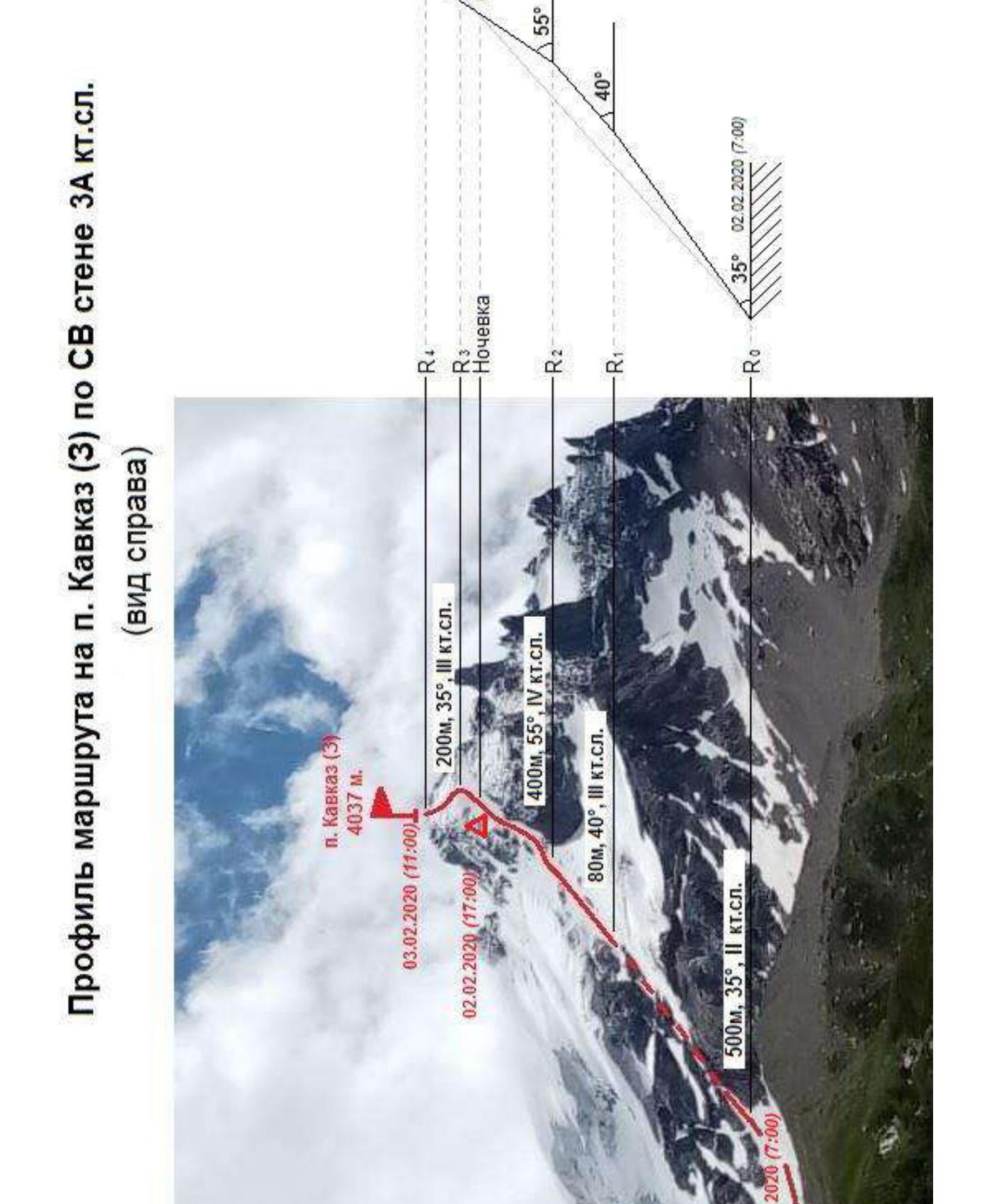
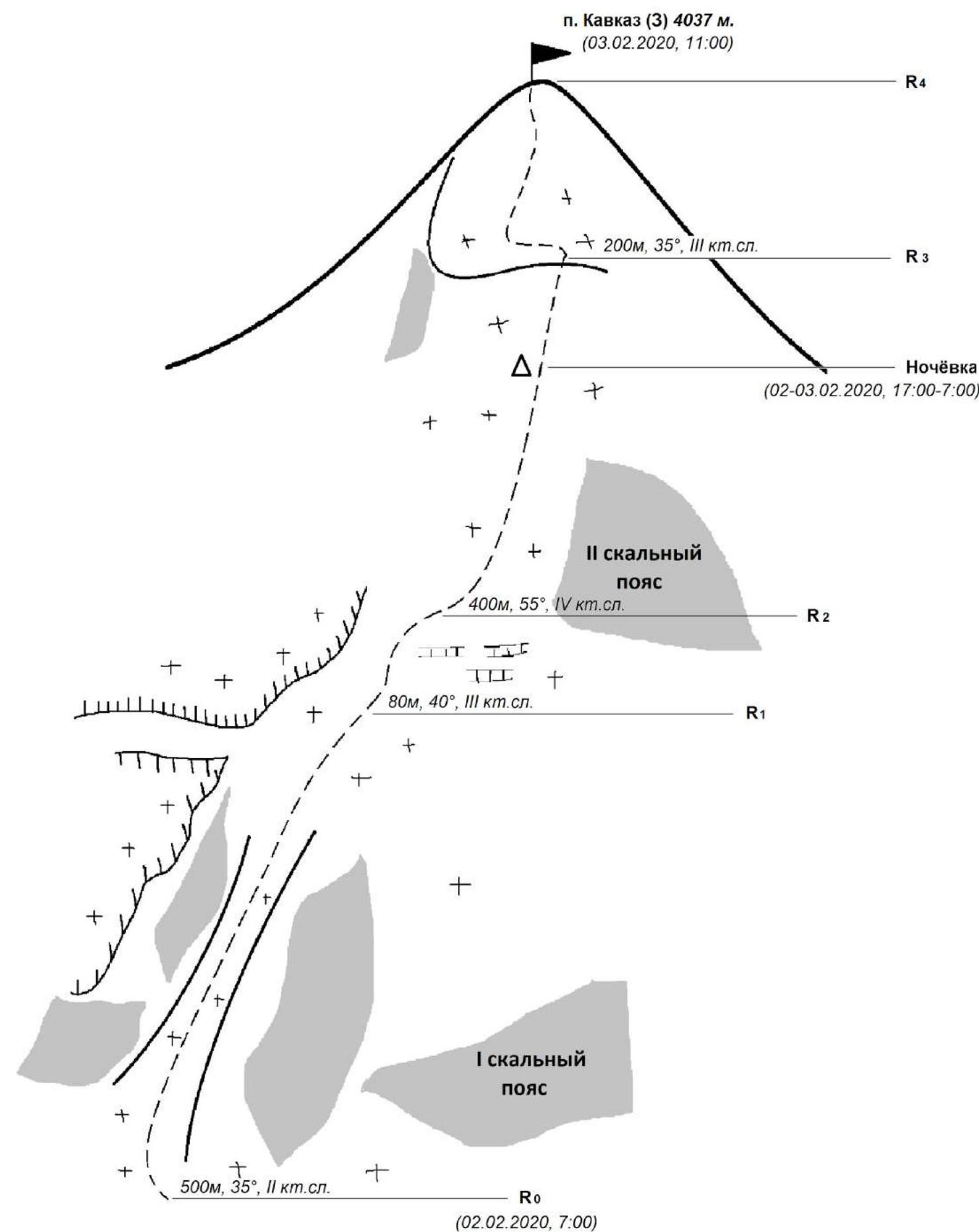
 Profile of the route to Pik Kavkaz (3) via NE wall, category 3A diff. (view from the right)
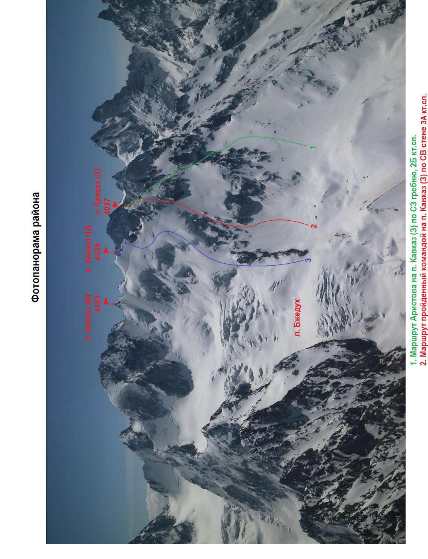
 Photopanorama of the area
 Map-scheme of the ascent area
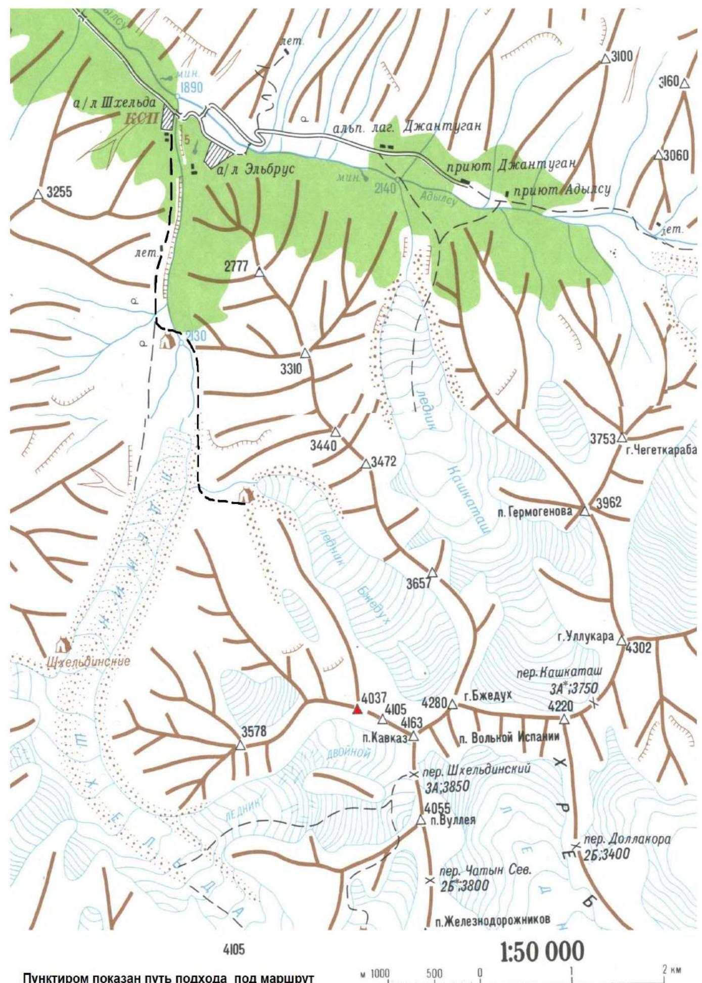
Geographical Location of the Area
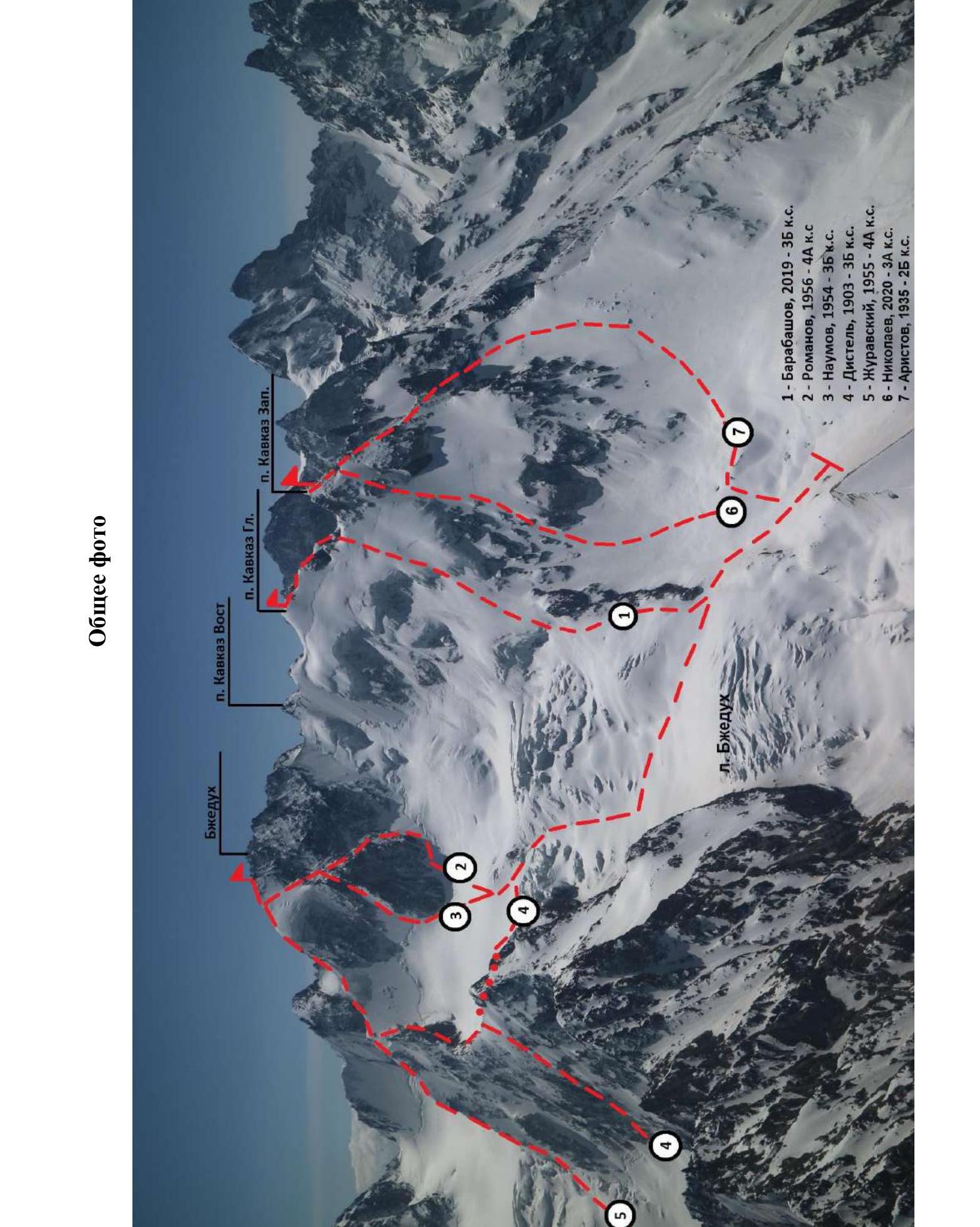
The object of the ascent — Pik Kavkaz Zapadny, is located in the Central Caucasus in the Shkhelda valley. The starting points can be the settlement of Elbrus or the alpine camp "Shkhelda". The spur of Pik Kavkaz is sandwiched between the glaciers Bzhedukh and Dvoynoy, and has 5 summits:
- Kavkaz Vostochny — 4163 m (in the Main Caucasian Range)
- Kavkaz 2-y Vostochny
- Kavkaz Glavny (Central) — 4105 m
- Kavkaz Zapadny — 4037 m
- Kavkaz Yugo-Zapadny — 3578 m
The approach to all the summits of the spur goes from the Shkhelda river valley, which is a left-bank tributary of the Adyl-Su river.
The northern slopes of the spur have a snow-ice character and descend from the Bzhedukh glacier.
From the alpine camp "Shkhelda" along the trail upstream along the Shkhelda valley, the approach is to the "Ulybka Shkheldy" overnight stays. Further:
- crossing the Shkhelda river to its right bank (in summer, the river is crossed via a suspended bridge);
- along the moraine, up to the left to the stream flowing from the left side from under the Bzhedukh glacier;
- crossing the stream;
- ascent along the ridge with vegetation.
Not reaching the northern slope of the North-Western ridge of Pik Kavkaz, we turn left and approach the slope of the North-Eastern wall.
In winter:
- the time to approach the "Ulybka Shkheldy" overnight stays is 1.5 hours;
- further to the overnight stays under the route — 3-3.5 hours.
From the overnight stays, the approach is to the first rock belt, then traverse to the left to the beginning of the snow-ice couloir. Here the route begins.
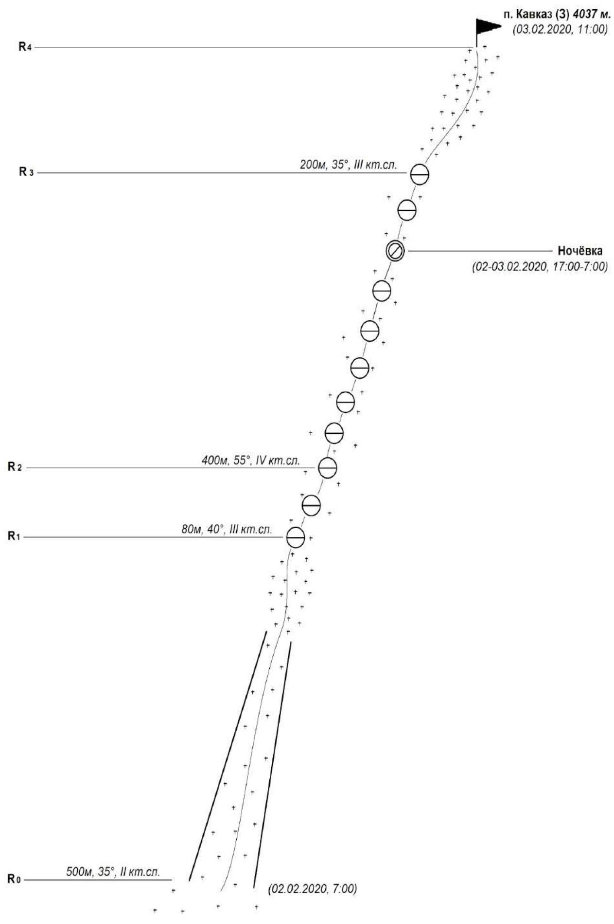
Technical photograph of the route to Pik Kavkaz (3) via NE wall, category diff.
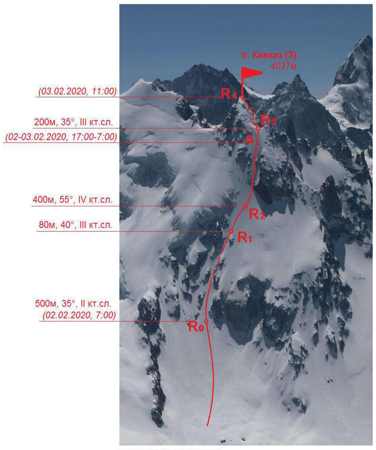 — the group's route.
2.2. Technical Characteristics of the Route Sections
| Section № | Character of the terrain | Category of difficulty | Length, m | Type and quantity of anchors |
|---|---|---|---|---|
| From the overnight stays, the approach is to the first rock belt, then traverse to the left to the beginning of the snow-ice couloir, where the route begins. | ||||
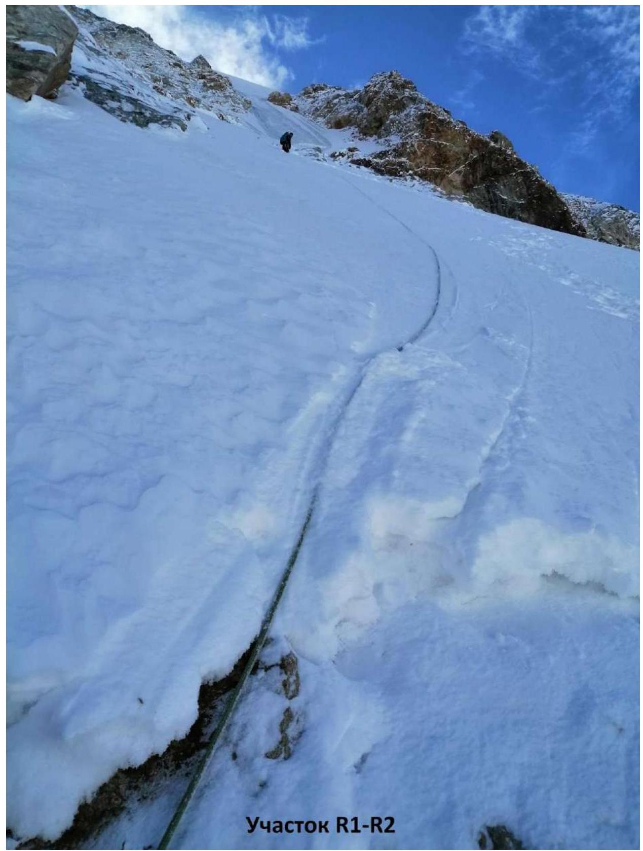
| R0–R1 | Ascent along the couloir, narrowing in the upper part between two rock ridges. | II | 500 m, 35° | Movement in crampons |
| R1–R2 | The couloir leads to a snow-covered slope (in summer, in the absence of snow, ice falls are possible here, which are bypassed to the right — 150 m). It is possible not to exit onto the slope, but to continue moving further up along the icy rocks of the couloir. | III | 80 m, 40° | Movement in crampons and ropes. Ice screws — 5 pcs. Anchors — 4 pcs. |
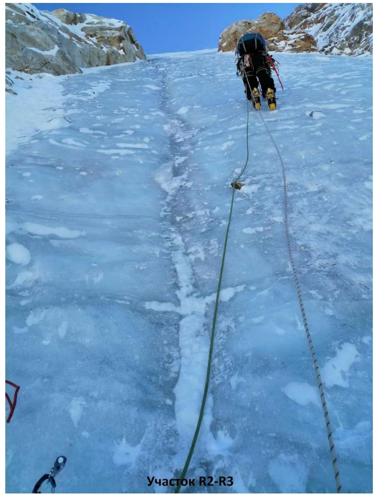
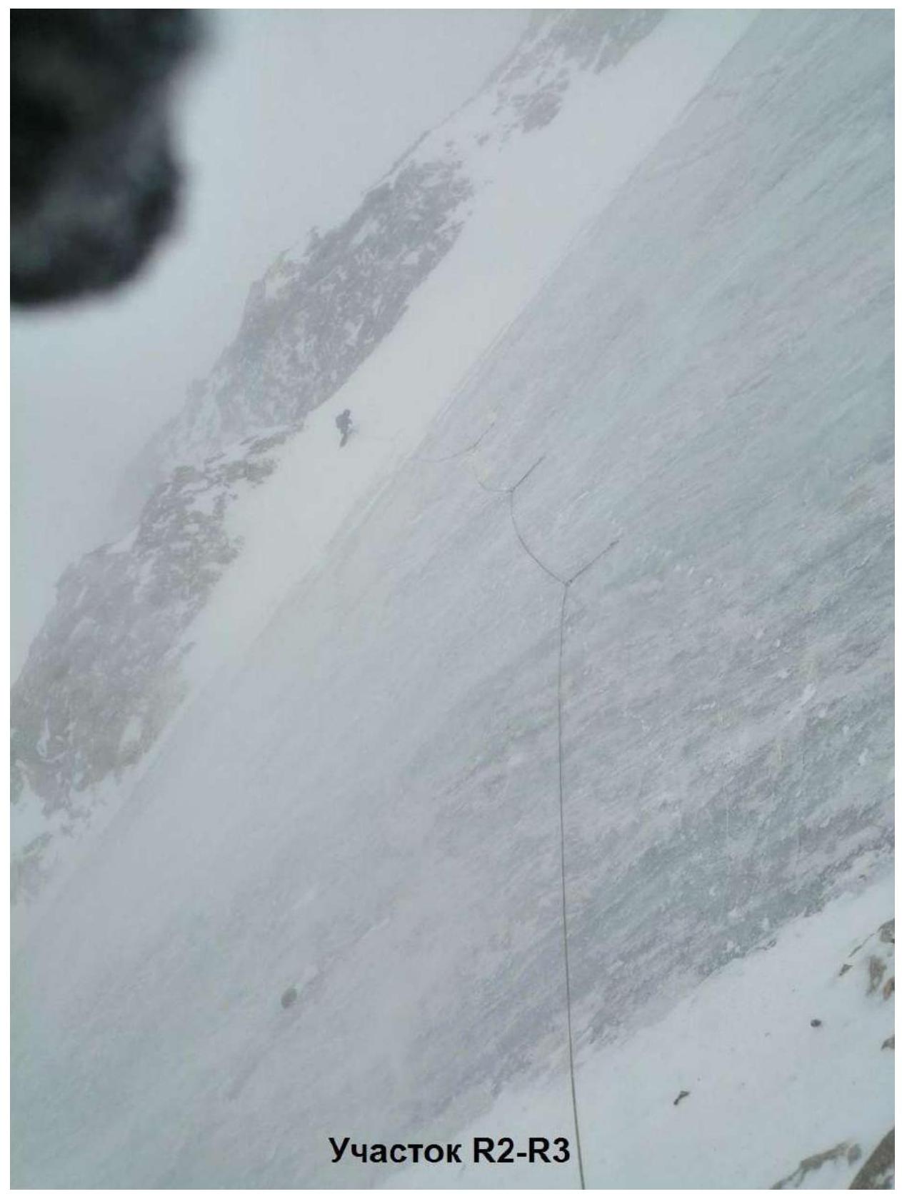
| R2–R3 | Exit to the ice to the left of the second rock belt. Further up the steep ice slope. Exit to a depression. In the upper part, the slope becomes gentler. | IV | 350 m — 55°, 50 m — 30° | Movement in crampons and ropes. Ice screws — 14 pcs. |
| R3–R4 | From the depression, along a steep ice slope, exit to the pre-summit ridge. Along it — exit to the Western summit of Pik Kavkaz (4037 m). | III | 130 m — 35°, 70 m — 35° | Movement in crampons and ropes. Ice screws — 4 pcs. Anchors — 6 pcs. |
Descent via the route 2B category diff. along the NW ridge.
Scheme of the route to Pik Kavkaz (3) via NE wall, category diff.
Scheme of the route to Pik Kavkaz (3) via NE wall, category diff. (in UIAA symbols)
3. Characteristics of the Team's Actions
Excerpt from the debriefing of the ascent
of the St. Petersburg-2 team (alpine club "Tekhnolog"), participating in the KBR Cup in the ice-snow class on Pik Kavkaz Zapadny via the NE wall (first ascent) category 3A diff. from February 2 to 3, 2020.
The debriefing is conducted by the senior coach of the alpine camp "Shkhelda", chief judge of the KBR Cup, Glushko V.I.
Speakers:
Nikolayev Yu.A. (team leader)
The tactical plan provided for: completing the ascent in two days, with one overnight stay on the ascent. The route to the summit was completed in 14 hours. The descent took 8 hours. Everything was according to the tactical plan.
Bivouac equipment: assault tent and mats. For insulation during the overnight stay, we used down jackets, backpacks, and a rope.
Radio communication: throughout the entire route, communication with the base was stable and clear. For communication, we used a Baofeng UV-82 8V radio station, frequency: 402.225.
All participants were sufficiently prepared for this ascent. Ice training on the Shkhelda glacier was conducted both upon arrival in the area and additionally on the day of the approach to the route. Also, a few days earlier, we had completed an ascent to the same summit via the Aristov route, along the NW ridge, category 2B diff. This route was our descent route.
On one of the days preceding the ascent, there was bad weather, and abundant snowfall occurred. Our assault camp was located closer to the descent route (2B), and it was left from the previous exit. Together, these nuances resulted in the approach to our route taking more time than we initially expected.
On the day of the ascent, the weather was clear, without wind, and the temperature was comfortable for work. The route begins at the lower part of the couloir. If we were to approach it directly, the path would be through an avalanche-prone slope, so we traversed to the right, moving under the first rock belt. The couloir had practically no fresh snow. We advanced through the first part of the route without being roped, taking turns leading and following. Approaching the second rock belt, before reaching the ice, we had to rope up and work "from the stance" since we were already on a mix of snow, ice, and rock underfoot.
Completing the ascent on the same day was not possible, so closer to the evening (having climbed six ropes of ice), we set up an overnight stay, digging out a small platform for the tent on the left side of the ice slope along the direction of movement. The overnight stay was lying down but "at the limit" — the exit from the tent began with a steep slope.
The next day, the weather worsened: the stance on the slope, cleared of snow to clip in the carabiner in half a minute, was completely covered in snow. We worked two more ropes of ice, where we exited into a depression. Then, roped together, we reached the summit.
The descent was made along the already familiar Aristov route, category 2B diff.
This ascent proceeded without any incidents: none of the participants were injured, and there were no falls.
Teams that will attempt this ascent should have:
- good ice equipment
- skills for working on winter ice.
During the ascent, there was clear interaction and understanding of the work among all team members. The leads were rotated, and everyone took turns being the first on the rope. I have no complaints about the participants.
Glushko V.I. (chief judge)
With which previously climbed routes can you compare this ascent?
Eliseev S.G. (participant)
This route, in its technical difficulty, is not inferior to the route to Sella, along the S wall of the 3rd ridge, category 3A diff.
Pasmurov A.Ya. (judge)
The team was in the sight of the judges' panel throughout the ascent. There are no comments on their work and communication.
Glushko V.I. (chief judge)
The route, by its technical characteristics, corresponds to category 3A diff. The route is confirmed. Compile a report and submit it for classification.
Debriefing conducted by: Senior coach of the alpine camp "Shkhelda": Glushko V.I. Judge: Pasmurov A.Ya. Secretary: Glushko E.V.
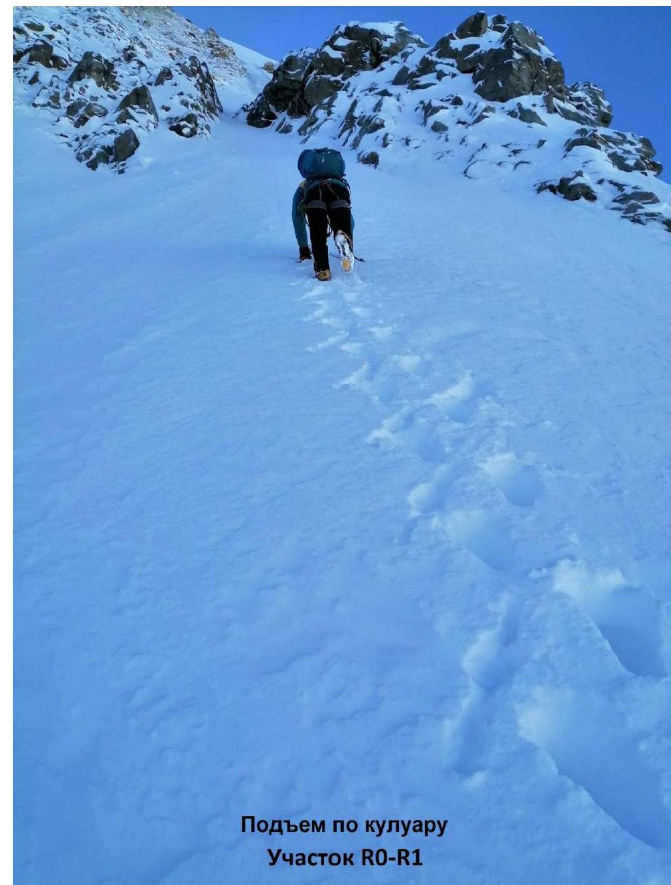
Ascent along the couloir. Section R0–R1