Report
of the Tashgorsportkomitet team on the ascent of Mt. Chatyn (main) 4368 m via the "diamond" of the northern wall (variant along the edge)
UzSSR, Tashkent 1981
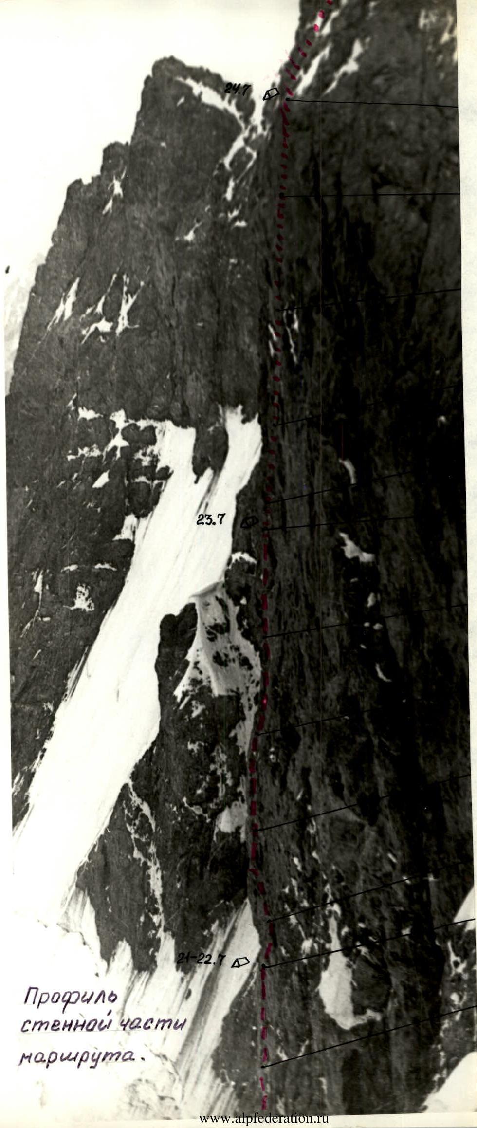
Profile of the wall section of the route
Orography and brief history of exploration
Mt. Chatyn is located in a spur of the Main Caucasus Range, branching off between the peaks of Malaya Ushba and Shchurovsky. The spur is a sharp rocky-ice (snow) ridge, with three distinct peaks: Western, Main, and Eastern Chatyn. The Western peak was first conquered in 1912 by Golubev via a relatively easy route from the Ushba plateau.
The exploration of Chatyn's wall began only in 1952. B.A. Garf's group passed a route through the Northern wall. In 1954, I.P. Leonov's group traversed the peaks Chatyn-Ushba-Mazeri, ascending via a steep counterfort of the Northern wall. In 1957, I.V. Solodueva's group traversed the eastern edge of the massif. It wasn't until 1959 that the "diamond" of the Northern wall was conquered - a huge black rocky overhang beneath the Main peak. Two teams - A. Snesarev's and L. Myshlyaev's - after a multi-day assault, established two routes of the highest category on Chatyn. To date, five routes have been passed through the "diamond" of the Northern wall (I. Chernoslivin, 1965, I. Bolizhevsky, 1969, V. Krakovich, 1972, in addition to the two mentioned above), the technical difficulty of which is undeniable, as proven by time.
Conditions of the ascent to Mt. Chatyn via the "diamond" of the Northern wall (variant along the edge)
The approaches to Chatyn's Northern wall are well-known. The climbing team and the support group, departing from the base camp at "Ulybka Shkheldy", reached the "German bivouac" via the Shkhelda glacier in 4 hours, where an intermediate camp was set up for communication. On the same day, having crossed the Lzhny Chatyn pass, the climbers and the observation group established a camp at Chatynskie nochyovki. After two days of observation, the wall's passage variant was finalized, and the tactical ascent plan was adjusted.
The route was completed in six days (one day was spent descending to the base camp). The ascent was complicated by the following factors:
- Snow pellets fell daily towards the end of the day.
- Climbing in the first half of the day was complicated by a thin crust of ice on the rocks and snow on the ledges.
- In the second half of the day, from 16:00 to 18:00, water flowed down the rocks, often in streams.
- Irregular rockfall and individual stones falling from the "roof" were observed throughout most of the daylight hours, with their frequency increasing towards the end of the day.
Tactical plan for the ascent to Mt. Chatyn (main) via the "diamond" of the Northern wall, variant along the edge
of the Tashgorsportkomitet team participating in the 1981 USSR Alpine Championship
Team leader - Popov G.Ya.
- July 18, 1981 - departure from the base camp under the Shkhelda glacier to Chatynskie nochyovki via German nochyovki and Lzhny Chatyn pass.
- July 19-20, 1981 - observation of the wall: selection of a safe starting point and time for the route, assessment of rockfall and avalanche risks, choice of the optimal route, clarification of relief details.
- July 21, 1981 - start of the route. Rapid passage of the bergschrund and the ice section above it. Transition to the right part of the rocky "paw", ascent to the sloping ledge where the Snesarev and Chernoslivin routes diverge. Overnight stay #1 at this location. The first rope team is Smirnov-Pertsiger. The difficulty of this section is approximately 5B.
- July 22-23, 1981 - from overnight stay #1, ascent via Snesarev's route to the point where it sharply turns left. Further, until the end of the wall, our route proceeds between Snesarev's and Chernoslivin's variants along the right edge of the wall. In case of completing the section in one day, overnight stay #2 on the diagonal of the wall; otherwise, descent to overnight stay #1. The first rope team is Tsoy-Popov. The difficulty of this section is approximately 6.
- July 24, 1981 - from overnight stay #2, ascent via the right part of the rocky pillar, which overhangs the diagonal of the wall, to sloping steep ledges. If a safe location is found, overnight stay #3; otherwise, descent to overnight stay #2. The first rope team changes. The difficulty of this section is 6.
- July 25, 1981 - ascent directly upwards from narrow inclined ledges via the rocky "knife", then via the upper part of the wall, heavily dissected by vertical grooves ("feathers") - exit to the "roof". Overnight stay #4. The first rope team changes; the difficulty of this section is 5B-6 category.
- July 26, 1981 - ascent via the narrowing counterfort and bypassing rocky bastions to the ridge, then along the ridge to the summit. Overnight stay #5 on the summit ridge.
- July 27, 1981 - descent via the route of 3A category to the west, and through the Ushba icefall, German nochyovki, to the base camp under the Shkhelda glacier.
- July 28-29, 1981 - reserve days for bad weather.
Adjustments made to the tactical plan during the ascent
- Overnight stay #1 is established at the point where Snesarev's route diverges to the left from the edge, i.e., 60 m higher than initially planned.
- On July 24, the wall section of the route was completed one day ahead of schedule due to the group's transition to Snesarev's route (last two ropes of the wall). The decision to abandon the planned route in the upper part of the wall was made due to the presence of large "live" rock detachments.
The planned tactical ascent plan was largely executed.
Brief explanation of the table of main characteristics
On July 18, the group departed from the base camp and reached Chatynskie nochyovki on the same day. On July 19-20, observation of the wall was conducted, and the route was clarified, with adjustments made to the tactical plan accordingly. The chosen route was conditionally named "variant along the edge". The so-called edge passes mainly between Snesarev's and Chernoslivin's routes and is clearly visible under soft western lighting of the wall.
July 21
- Departure under the wall at 4:00.
- The Smirnov-Pertsiger rope team leads.
- Having overcome the bergschrund (R1-R2) and the ice slope above it (R2-R3), they reached the rocky "paw".
- The rocks are steep, destroyed, with some ice, especially in internal corners and chimneys.
- On the second rope along the rocky "paw" (R3-R4), the 1st control cairn is left.
- Climbing is complex, with ladders used in some places.
- The R6-R7 section of our route coincides with Snesarev's route, which also follows the edge at this point.
- Snesarev's route then turns left upwards via a couloir-chimney; our route continues straight up.
- A note is retrieved from a control cairn on Snesarev's route (2nd control cairn on our route).
- At the fork of the routes, on a steep rocky ledge, overnight stay #1 is established.
- It is snowing, with water cascading down the rocks from the "roof".
July 22
- The Tsoy-Popov rope team leads.
- Ascent via overhanging rocks. Climbing is very difficult, with ladder usage.
- In the second half of the day, the Pertsiger-Smirnov rope team begins processing.
- 2.5 ropes of category 6 are passed, and despite simpler rocks above, processing is halted due to the danger of stones falling from the "roof".
- Many "stars" (traces of falling stones) are observed on the rocks.
- 13 working hours.
July 23
- The Tsoy-Popov rope team leads.
- Passing fixed ropes is complicated by ice on the ropes.
- Rocks are covered with a thin layer of ice.
- The 3rd control cairn is left at the junction of two previously fixed ropes, on a narrow 20 cm ledge on the edge.
- A note is placed in a gas canister.
- From the upper point reached on July 22, ascent is made left upwards via steep, destroyed rocks of a poorly defined gully to the "green" cornice overhanging the diagonal of the "diamond" (R10-R11).
- Further ascent is made via an internal corner, then via a cleft, exiting to a horizontal narrow ledge-slit.
- Snesarev's route passes 15 m to the left, via a large gully.
- Processing above the ledge had to be stopped due to abundant water on the rocks and worsening weather.
- 13 working hours.
July 24
- The Smirnov-Pertsiger rope team leads.
- 10 m are passed via fixed ropes hung the previous evening, followed by extremely difficult climbing via overhanging rocks straight up.
- Climbing is complicated by ice on rocks, snow pellets on minimal footholds, and water flowing near the rocks.
- The end of the first rope is secured to a large rock detachment left of the cornice, at the base of a poorly defined internal corner with "deaf" cracks.
- To secure the ropes, an additional piton is driven.
- The next rope is also challenging due to a lack of cracks for reliable piton placement.
- Exit is made to an inclined rocky ledge with snow, which marks the upper overhanging part of the rocks - the exit to the "roof".
- At this point, the group was forced to join Snesarev's route due to safety concerns.
- The previously planned path proved excessively dangerous due to giant "live" rock detachments.
Two ropes of very difficult climbing, severely hindered by water, via Snesarev's route (R15-R17), and the wall section of the route are completed.
On the "roof", the group was forced to make a traverse left onto a poorly defined ridge under an overhanging wall due to high rockfall risk.
- 16 working hours; everyone is soaked.
- Overnight stay is in a sitting position, with heavy snowfall.
July 25
Departure was delayed due to drying gear and some clothing. Nonetheless, the "roof" was passed that day. Its complexity exceeded expectations based on consultations received. The character of the route on the "roof" is combined, with much ice; on rocks, it is of accretionary origin.
- Rope teams worked alternately: Pertsiger-Smirnov, Tsoy-Popov.
- 12 working hours.
- Exit to the summit.
- Overnight stay 40 m from the summit on a convenient platform.
July 26. Descent to the Ushba plateau via the route of 3A category through Western Chatyn. Then down the Ushba icefall to the base camp under the Shkhelda glacier.
Conclusion
In the opinion of the group members, the chosen variant of passing the "diamond" of Chatyn's Northern wall is not inferior in technical complexity to Snesarev's and Chernoslivin's routes, and in the middle and lower parts of the wall, it differs from the latter by a more vertical ascent.
Since the route follows the "edge" in this section, there is much less water on it compared to neighboring routes.
Among all the high-category routes passed by the group, the ascent to Chatyn via the "edge" stands out for its particular complexity due to the presence of accretionary ice on the slopes, snow pellets, and abundant water, which necessitated a more cautious, safety-conscious tempo.
Additionally, it is worth noting that out of 15 ropes on the wall section, 13 were passed for the first time.
The significant experience of joint ascents and a favorable psychological climate within the group allowed for the completion of this ascent within the framework of the USSR Alpine Championship at an optimal pace and without violating safety regulations.
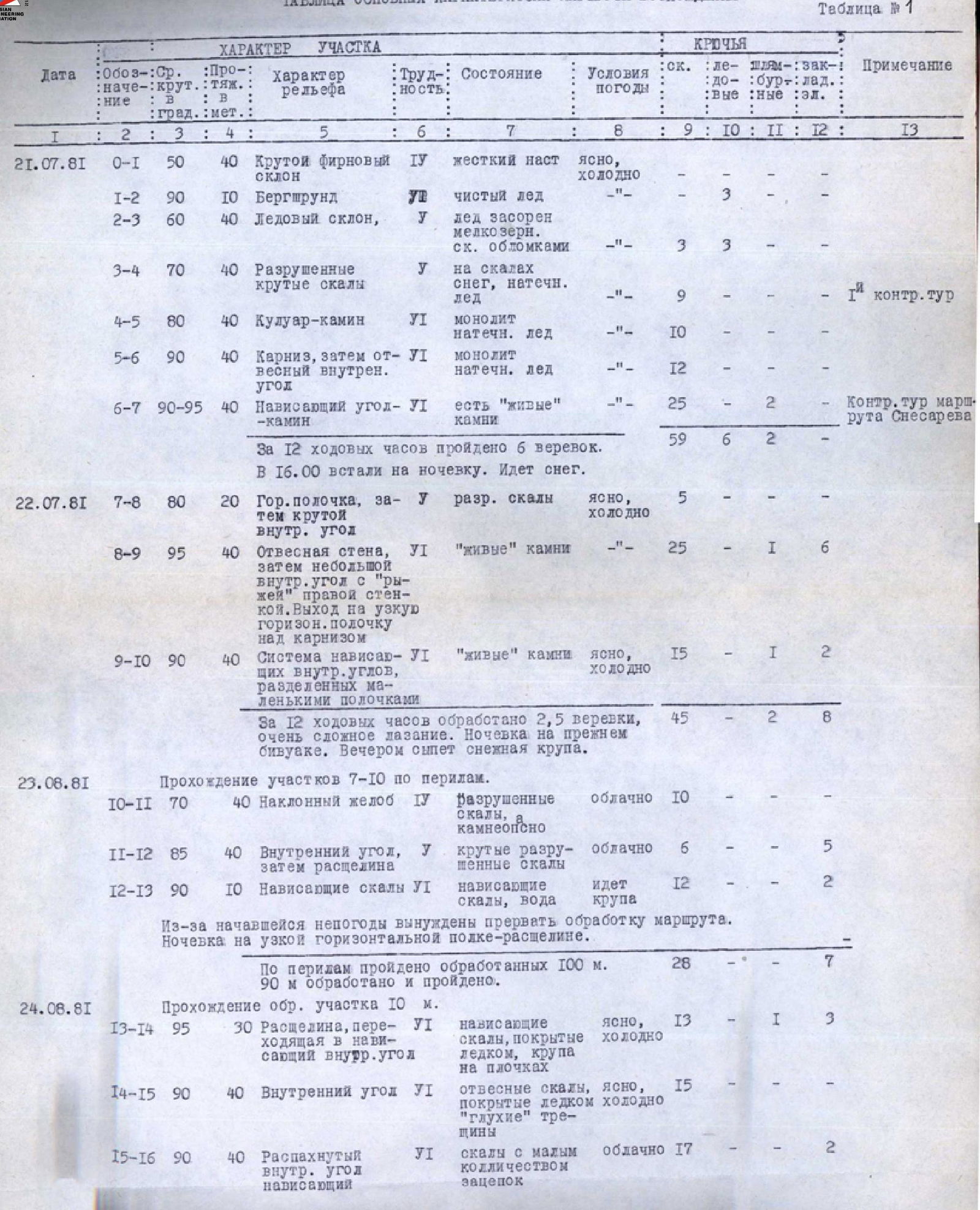
Table № 1
Table of main characteristics of the ascent route
| R | Avg. steepness, deg. | Length, met. | Character of relief | Difficulty | State | Weather conditions | Rock pitons | Ice screws | Pitons | Chocks | Remarks |
|---|---|---|---|---|---|---|---|---|---|---|---|
| R0–R1 | 50 | 40 | Steep firn slope | ІV | Hardened snow crust | Clear, cold | - | - | - | - | |
| R1–R2 | 90 | 10 | Bergschrund | Clean ice | - | 3 | - | - | - | ||
| R2–R3 | 60 | 40 | Ice slope | У | Ice contaminated with small rock debris | - | 3 | 3 | - | - | |
| R3–R4 | 70 | 40 | Destroyed steep rocks | У | Snow, accretionary ice | - | 9 | - | - | - | 1st control cairn |
| R4–R5 | 80 | 40 | Couloir-chimney | УІ | Monolithic accretionary ice | - | 10 | - | - | - | |
| R5–R6 | 90 | 40 | Cornice, then steep internal corner | УІ | Monolithic accretionary ice | - | 12 | - | - | - | |
| R6–R7 | 90–95 | 40 | Overhanging corner-chimney | УІ | Presence of "live" rocks | - | 25 | 2 | - | - | Control cairn of Snesarev's route |
For 12 working hours, 6 ropes were passed. Overnight stay commenced at 16:00. It is snowing.
| R | Avg. steepness, deg. | Length, met. | Character of relief | Difficulty | State | Weather conditions | Rock pitons | Ice screws | Pitons | Chocks | Remarks |
|---|---|---|---|---|---|---|---|---|---|---|---|
| 22.07.81 | R7–R8 | 80 | 20 | Horizontal ledge, then steep internal corner | У | Destroyed rocks | Clear, cold | 5 | - | - | - |
| R8–R9 | 95 | 40 | Steep wall, then small internal corner with "rusty" right wall. Exit to narrow horizontal ledge above cornice | УІ | "Live" rocks | - | 25 | 1 | - | 6 | |
| R9–R10 | 90 | 40 | System of overhanging internal corners separated by small ledges | УІ | "Live" rocks | Clear, cold | 15 | 1 | - | 2 |
For 12 working hours, 2.5 ropes were processed, with very difficult climbing. Overnight stay was at the previous bivouac. Snow pellets fell in the evening.
23.07.81 Passing sections R7–R10 via fixed ropes.
| R | Avg. steepness, deg. | Length, met. | Character of relief | Difficulty | State | Weather conditions | Rock pitons | Ice screws | Pitons | Chocks | Remarks |
|---|---|---|---|---|---|---|---|---|---|---|---|
| R10–R11 | 70 | 40 | Inclined gully | ІV | Destroyed rocks, rockfall-prone | Cloudy | 10 | - | - | - | |
| R11–R12 | 85 | 40 | Internal corner, then cleft | У | Steep destroyed rocks | Cloudy | 6 | - | - | 5 | |
| R12–R13 | 90 | 10 | Overhanging rocks | УІ | Overhanging rocks, water | Snow pellets | 12 | - | - | 2 |
Due to worsening weather, processing of the route was halted. Overnight stay was on a narrow horizontal ledge-cleft.
100 m were passed via fixed ropes. 90 m were processed and passed.
24.07.81 Passing processed section 10 m.
| R | Avg. steepness, deg. | Length, met. | Character of relief | Difficulty | State | Weather conditions | Rock pitons | Ice screws | Pitons | Chocks | Remarks |
|---|---|---|---|---|---|---|---|---|---|---|---|
| R13–R14 | 95 | 30 | Cleft transitioning to overhanging internal corner | УІ | Overhanging rocks covered with ice, snow pellets on ledges | Clear, cold | 13 | 1 | - | 3 | |
| R14–R15 | 90 | 40 | Internal corner | УІ | Steep rocks covered with ice, "deaf" cracks | Clear, cold | 15 | - | - | - | |
| R15–R16 | 90 | 40 | Wide open internal corner, overhanging | УІ | Rocks with few holds | Cloudy | 17 | 2 | - | - |
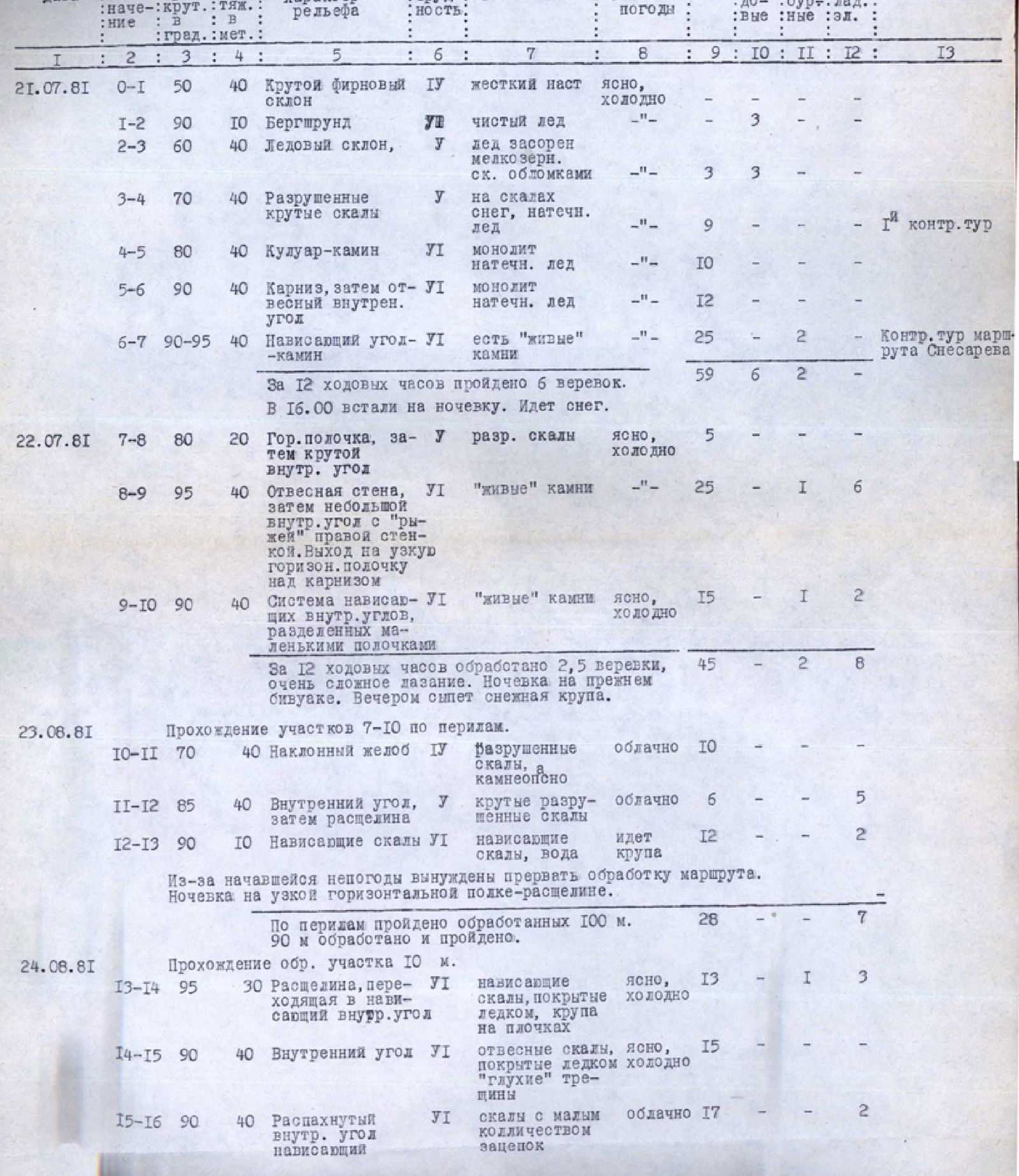
Continuation of Table № 1
| R | Avg. steepness, deg. | Length, met. | Character of relief | Difficulty | State | Weather conditions | Rock pitons | Ice screws | Pitons | Chocks | Remarks |
|---|---|---|---|---|---|---|---|---|---|---|---|
| R16–R17 | 85 | 40 | Internal corner, couloir | УІ | Snow, accretionary ice, water flowing | Snow pellets | 14 | 2 | - | 3 |
Overnight stay on the "roof". For safety reasons, the group traversed left onto a small ridge under an overhanging wall.
| R | Avg. steepness, deg. | Length, met. | Character of relief | Difficulty | State | Weather conditions | Rock pitons | Ice screws | Pitons | Chocks | Remarks |
|---|---|---|---|---|---|---|---|---|---|---|---|
| 25.07.81 | R17–R18 | 50 | 80 | Ice slope | ІV | Hard ice with crust, rockfall-prone | Clear, cold | 3 | 3 | - | - |
| R18–R19 | 60 | 40 | Traverse along the boundary of rocks and ice | У | Steep accretionary ice on rocks, rockfall-prone | Clear, cold | 4 | 3 | - | 2 | |
| R19–R20 | 60 | 80 | Ice couloir | У | Steep ice with crust, rockfall-prone | Clear, cold | 4 | 9 | - | - | |
| R21–R22 | 80 | 120 | Steep rocky ridge | У | Steep destroyed rocks | Cloudy | 25 | - | - | 5 | |
| R22–R23 | 60 | 40 | Snow-rock ridge | ІV | Destroyed rocks | Snow pellets | 7 | - | - | 2 | |
| R23–R24 | 45 | 40 | Snow-rock ridge | ІІІ | Destroyed rocks | Snow pellets | 5 | - | - | - | |
| R24–R25 | 15 | 40 | Snow ridge | ІІ | Soaked deep snow | Snow pellets | - | - | - | - | |
| R25–R26 | - | 40 | Rocky ridge | ІІІ | Destroyed rocks | Snow pellets | 3 | - | - | - |
Reached the summit. Set up for the night on a convenient platform 40 m from the summit. Reached the summit at 20:00.