Peak 3200.0 (Terskolak Zapadny) Route: via the southern edge Category of complexity — 4B cat. dif. (rocky) Leader: V. Babkin Central Caucasus, Prielbrusye, Terskol gorge Section in KMGV — 2.4. E-mail — ZHUR58@RAMBLER.RU
Report
On the first ascent of the climbing route to peak 3200.0 (Terskolak Zapadny) "via the southern edge 4B cat. dif. (rocky)". At the mountaineering event of the Higher Mountain School "School of Mountain Training of the Ministry of Defense of the Russian Federation" in 2012.
Region: Kabardino-Balkarian Republic. Dominant country: Central Caucasus Gorge: Terskol. Ridge: dominant massif: southeastern spur of Elbrus "Terskolak - TersakItkolbashi". Peak: 3200.0 m (Terskolak Zapadny). Route: via the southern edge. Level of complexity: 4B cat. dif. (rocky).
Prepared by:
- Dusharin I. T.
- Babkin V.
- Zhuravlev S.
September 2012
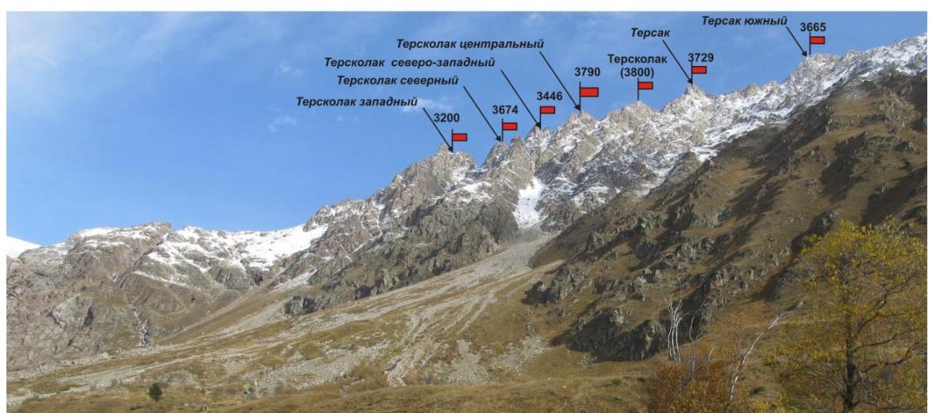
PANORAMA OF THE TERSKOLAK MOUNTAIN MASSIF OF THE SOUTHEASTERN SPUR OF ELBRUS
Photo from the valley of the Terskol river (Terskol gorge)
Route Description
The route "Via the Southern Edge" is a characteristic sports rock route of 4B cat. dif., with a full set of natural obstacles corresponding to routes of this level.
Approach: the ascent is made from a bivouac in the upper reaches of the Terskol gorge. From the village of Terskol to the bivouac — 2 hours 30 minutes. First along a dirt road to the cowshed along the Terskol river, then along a well-defined trail to the bivouac.
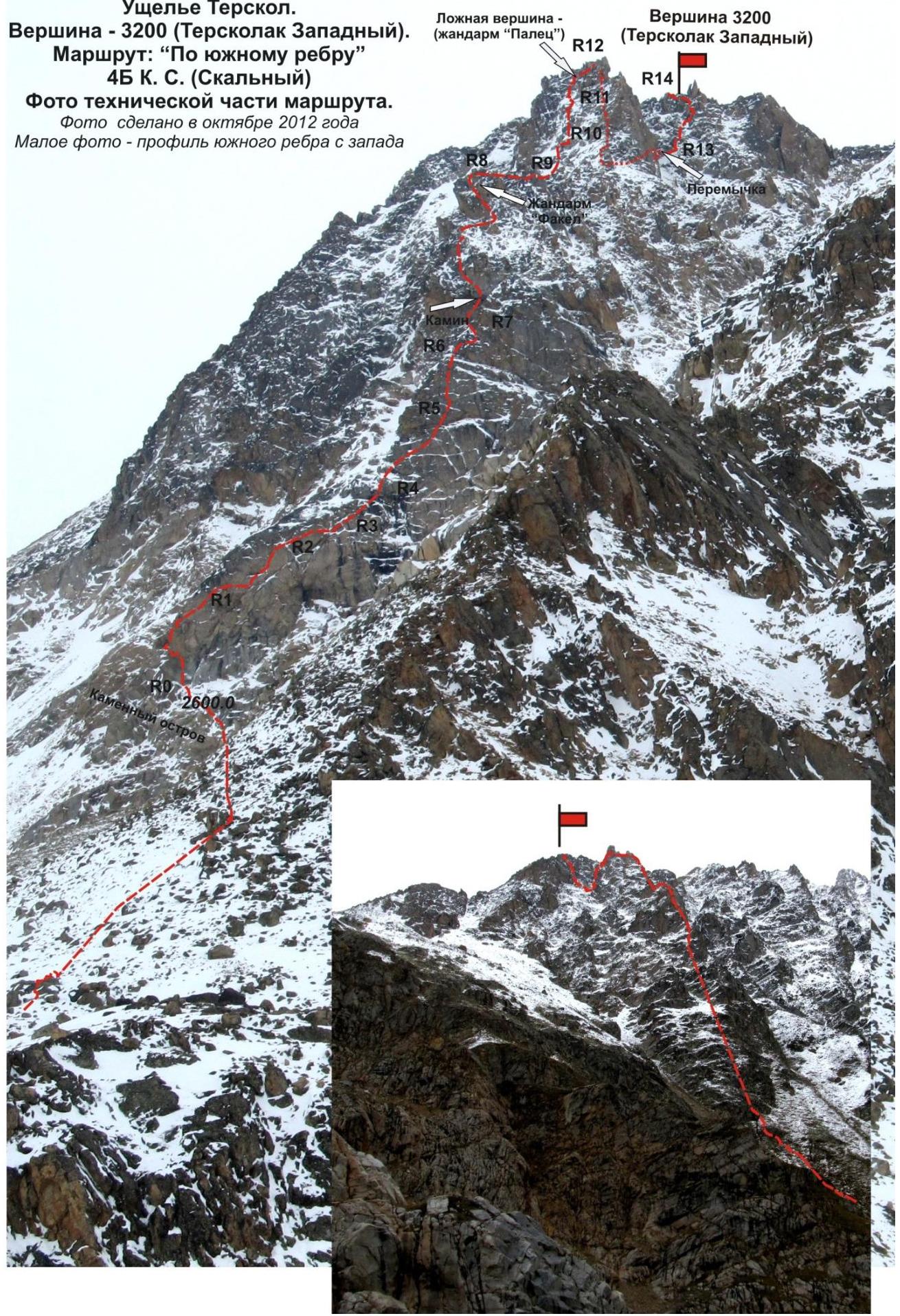
From the bivouac, ascend along grassy slopes to the base of the southern edge and rise to a rocky outcrop at the base of the edge. The rocky outcrop has a convenient place for organizing a rope team. Here begins the technical part of the route.
Technical part: the route begins with an ascent along rocks in the direction of the " Torch" gendarme. The gendarme is well-defined and serves as a characteristic landmark. Movement begins along simple rocks, turning into inclined slabs with oblique shelves. Further — approach to the inner corner. It is more convenient to bypass the inner corner along a series of shelves and small walls to the right along the route.
The first difficult place when ascending to the "Torch" gendarme is a traverse bypassing the stone block "Mushroom" (psychologically complex place!). After bypassing the stone block "Mushroom" — exit to the rocky edge of the southern rib. Along rocks of medium complexity with sections above medium, ascend under a smoothed wall.
Here begins the "small key" of the route — ascent to the "Torch" gendarme. First, an oblique traverse of a smoothed slab, then ascent along a technically complex chimney. On the "Torch" gendarme, the first ascenders installed a control cairn.
Further, adhering to the direction along the edge of the southern rib, ascend under a steep smoothed wall. This is the key of the route: 20 m of very complex climbing with a minimum of points for organizing insurance. (The work of the first — only in rock shoes!).
From the "Torch" gendarme along the edge of the southern rib, consisting of a series of walls, shelves, and slabs of complex climbing, but with an abundance of relief for organizing intermediate points, ascend to a sharp gendarme.
From the gendarme, descend to a ridge saddle by rappelling, then transition along the saddle under the wall of the false summit (gendarme "Finger").
Along complex rocks, ascend to the false summit ("Gendarme 'Finger'").
From the false summit:
- descend to the saddle under the summit tower (rappel 50 m);
- then along the saddle approach under the wall;
- along the right part of the wall, ascend to the summit.
The summit is a rise in the rocky ridge clearly expressed. The cairn is easily found in the center of the summit. On the summit, a note from the group UTS MO RF 2011 (leader Zhuravlev S. V.) was found.
Descent from the summit:
- Descend along the northern slope along the route (approximately 2A–2B cat. dif.).
- Then bypass the mountain Terskolak Zapadny, leaving it to the left.
- Approach along talus slopes to the tongue of the Terskolak glacier (to the upper Terskol camps near the glacial lakes).
- From the camps, a weakly expressed trail along the "barranii lby" and a grassy slope leads to the Terskolak gorge to the lower Terskol camps.
- Further, the path along a well-defined trail to the cowshed, then along a dirt road to the village Terskol.
Equipment: to complete the ascent as part of a sports group of 4 people on the route, the following special equipment is required:
-
Personal standard
-
Group:
- Main rope 10 mm — 2×50 m
- Rock hammer — 2 pcs.
- Rock pitons — 2 pcs.
- Ice axe — 1 pc.
- Protection elements — 12 pcs.
- Friends — 6 pcs.
- Ice screws — 0 pcs.
- Quick draws — 16 pcs.
- Slings — 10 pcs.
Passport
- Section number according to KMGV — 2010 — 2.4.
Central Caucasus, mountain region — Prielbrusye, Terskol gorge, SE spur of Elbrus
- Name of the peak: 3200.0 (Terskolak Zapadny)
height: 3200.0
Route: via the southern edge
- Category of complexity: 4B cat. dif.
- Character of the route — rocky.
- Height difference of the route: 600 m
- Length of the route: 860 m
- Length of sections of the highest category of complexity:
1 cat. dif. — 0 sections — 0 m, 2 cat. dif. — 1 section — 50 m, 3 cat. dif. — 7 sections — 370 m
4 cat. dif. — 6 sections — 155 m, 5 cat. dif. — 6 sections — 145 m, 6 cat. dif. — 0 sections — 0 m
- Average steepness: main part of the route — 70°
entire route — 65°
- Number of pitons used:
Total used on the route:
- rock pitons — 21,
- protection — 84,
- bolt pitons stationary — 0,
- ITO — 0,
- bolt pitons removable — 0. Left "pitons" on the route: total — 4; including bolt pitons — 0.
- Exit to the route — 4:00, October 19, 2012
Exit to the summit — 18:00, October 19, 2012 Return to BL — 21:00, October 19, 2012
- Team's walking hours: — 14 hours. 12 > Leader: Vyacheslav Babkin (CMS, instructor-methodologist 2nd category, Yekaterinburg).
Team members:
- Coach: Dusharin I. T.
Central Caucasus, Prielbrusye, Terskol gorge, SE spur of Elbrus
Peak 3200 m (Terskolak Zapadny)
Route: "Via the southern edge" 4B (rocky)
(approximately)
(table of natural obstacles of the route)
| Section | Length | Steepness | Character of relief | Cat. dif. | Number of Pitons/protection |
|---|---|---|---|---|---|
| approach | From pos. Terskol along Terskol gorge to the beginning | ||||
| R0 — start of the route — rocky outcrop at the base of the southern edge | of the route — 3 hours. Of which — 2 hours 30 minutes along the valley (dirt road, trail), then along a grassy and talus slope to the rocky outcrop — 30 minutes. | ||||
| R0–R1 Ascent along a slab with grassy shelves in the direction of the "Torch" gendarme | 50 | 45 | Dense rocks (subjective rockfall hazard) | 2+ | 0 / 0 |
| R1–R2 Ascent along an inclined wall in the direction of the "Torch" gendarme | 100 | 50 | Dense rocks | 3+ | Used: 0 / 8, left: 0 / 0 |
| R2–R3 Ascent along an inclined wall to the "Torch" gendarme. Bypass of the inner corner | 50 | 50 | Dense rocks | 3+ | Used: 1 / 6, left: 0 / 0 |
| R3–R4 Ascent along an inclined wall to the "Torch" gendarme. Traverse and bypass of the stone block "Mushroom" | 50 | 60 | Dense rocks | 4- | Used: 4 / 6, left: 1 / 0 |
| R4–R5 Ascent along an inclined wall to the "Torch" gendarme. Ascent along a rocky edge and wall | 50 (5 M) | 50(60) | Dense rocks | 3+ (4-) | Used: 0 / 6, left: 0 / 0 |
| R5–R6 Passage of steep oblique shelves and walls between them | 15 10 35 | 60 70 50 | Dense rocks | 4− 5+ 3+ | Used: 0 / 6, left: 1 / 0 |
| R6–R7 Traverse of the wall and passage of the chimney — Small key of the route. Ascent to the "Torch" gendarme | 15 35 | 75 75 | Traverse of the wall Rock chimney | 5− 5− | Used: 6 / 2, left: 1 / 0 |
| R7–R8 Bypass of the inner corner along shelves and slabs | 60 | 50 | Rocks. (subjective rockfall hazard b) Control cairn | 4+ | Used: 0 / 8, left: 0 / 0 |
| R8–R9 Ascent along the edge of the rib with an oblique traverse of the wall in the upper part | 50 | 60 | Dense rocks | 4+ | Used: 0 / 6, left: 0 / 0 |
| R9–R10 Passage of the wall with a shelf in the middle KEY OF THE ROUTE! | 20 | 60 | Dense rocks | 5+ | Used: 2 / 4, left: 0 / 0 |
| R10–R11 Passage of a series of small walls and slabs along the line of the edge | 80 | 50 | Dense rocks | 3+ | Used: 0 / 10, left: 0 / 0 |
| R11–R12 Ascent to the "Otkol" gendarme along the wall and descent (rappel) from it to the saddle, passage along the ridge of the saddle | 20 5 15 | 70 70 60 | Rock monolith rappel | 5+ 3 | Used: 4 / 6, left: 2 / 0 |
| R12–R13 Ascent to the pre-summit gendarme "Finger". Descent (rappel) to the saddle, approach along the saddle under the wall | 45 50 50 | 65 75 15 | Rock monolith rappel | 5- 5- 3 | Used: 2 / 8, left: 2 / 0 |
| of the summit tower. | |||||
| R13–R14 Passage of the wall of the summit tower and exit to the summit | 50 | 50 | Rocks, weakly expressed counterfort | 3+ | Used: 0/6, left: 0/0 |
| R14 — summit Terskolak Zapadny (3200 m) | Summit — a rocky tower in the ridge. Expressed clearly. Cairn in the center. On the site near the cairn, a group of 4–6 people can be accommodated. | ||||
| DESCENT | Descent along the northern slope. Approximately 2B cat. dif. Further through the southern step of the Terskolak pass, descent to the valley of the Terskol river along a tourist trail leading from the pass. |
Summary:
Length of the route — 860 m. Average steepness — 65°, on key sections — 70°. Character of relief — rocky
Sections:
- 1 cat. dif. — 0 sections — 0 m
- 2 cat. dif. — 1 section — 50 m
- 3 cat. dif. — 7 sections — 370 m
- 4 cat. dif. — 6 sections — 155 m
- 5 cat. dif. — 6 sections — 145 m
- 6 cat. dif. — 0 sections — 0 m
Pitons and protection used: 21 (84). Left pitons and protection: 4 (0)
Note 1: the group used for insurance:
- camalots — 8 pcs
- hex — 5 pcs
- stoppers — 8 pcs
- channel hook — 6 pcs
- anchor pitons — 4 pcs
- extension slings 1.2 m — 4 pcs
- ropes — 3×50 m
- quick draws (equipped with carabiners) — 14 pcs
- carabiners — 8 pcs
- expendable slings 2–5 m, as well as personal equipment and experience of the first ascenders of the club "SaukPay".
Note 2: in the table, in brackets, the length, steepness, and complexity of non-characteristic short sections included in the overall length are given.
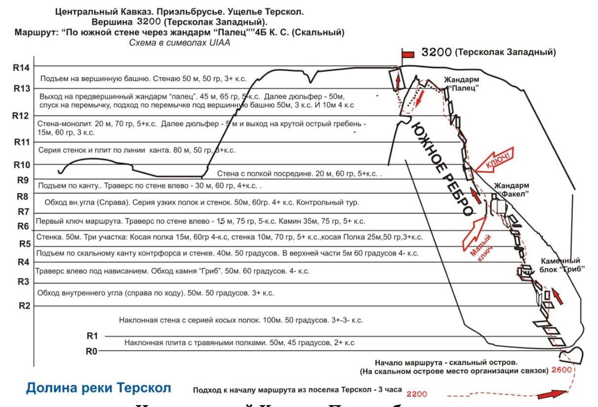
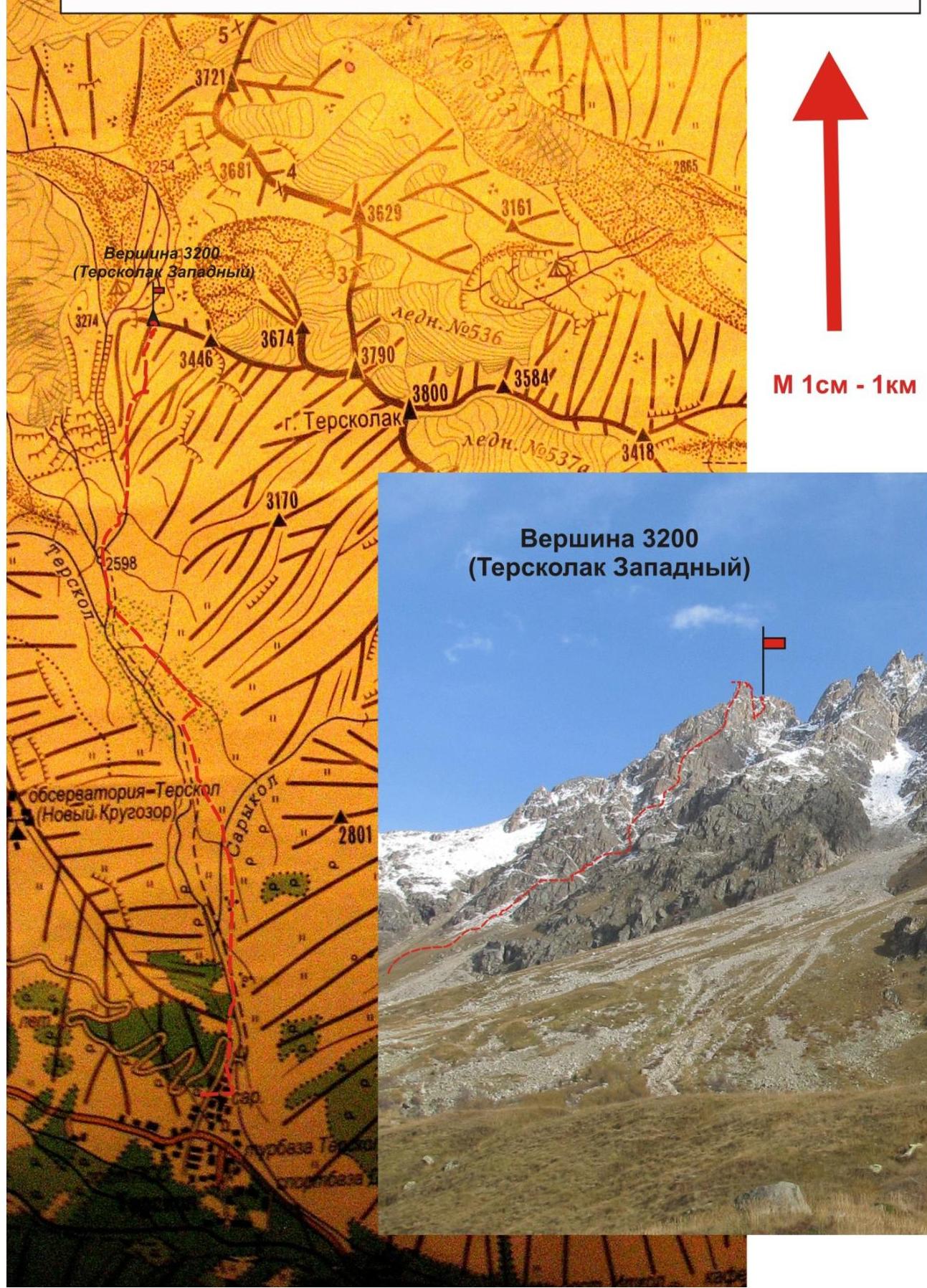
Central Caucasus. Prielbrusye. Terskol gorge. Peak — 3200 m (Terskolak Zapadny). Route: "Via the southern edge" 4B (rocky).
- Scheme of the approach and from the summit from the Terskol gorge with
a drawing of the route.
Central Caucasus. Prielbrusye. Terskol gorge. Peak — 3200 m (Terskolak Zapadny). Route: "Via the southern edge" 4B cat. dif. (rocky)
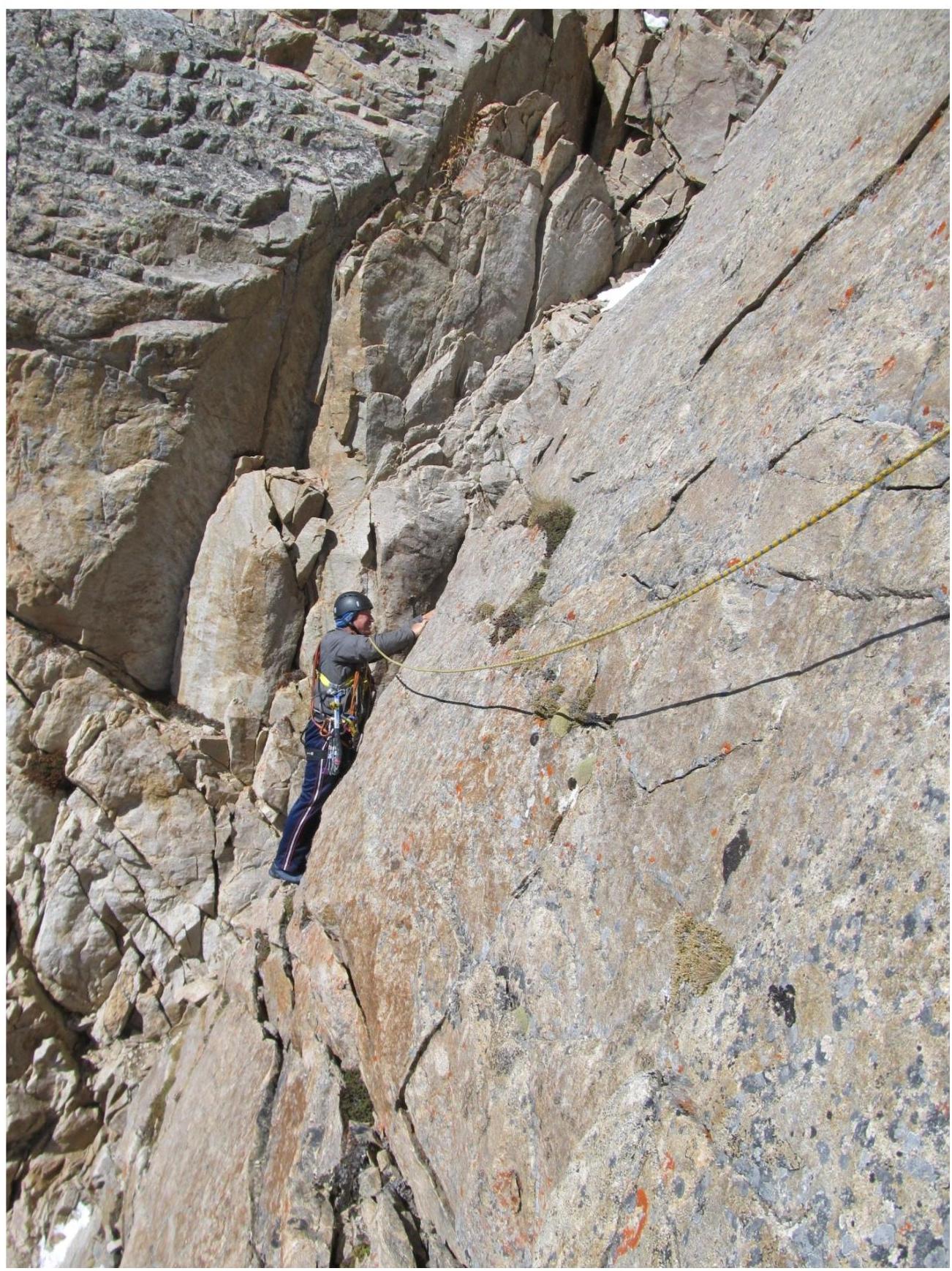
- Photo of the technical part of the route. Photo taken in October 2012.
- Small photo — profile of the southern edge from the west
Central Caucasus. Prielbrusye. Terskol gorge. Peak — 3200 m (Terskolak Zapadny). Route: "Via the southern edge" 4B cat. dif. (Rocky)
- Profile of the upper part of the route from the northwest
- Photo taken in October 2012
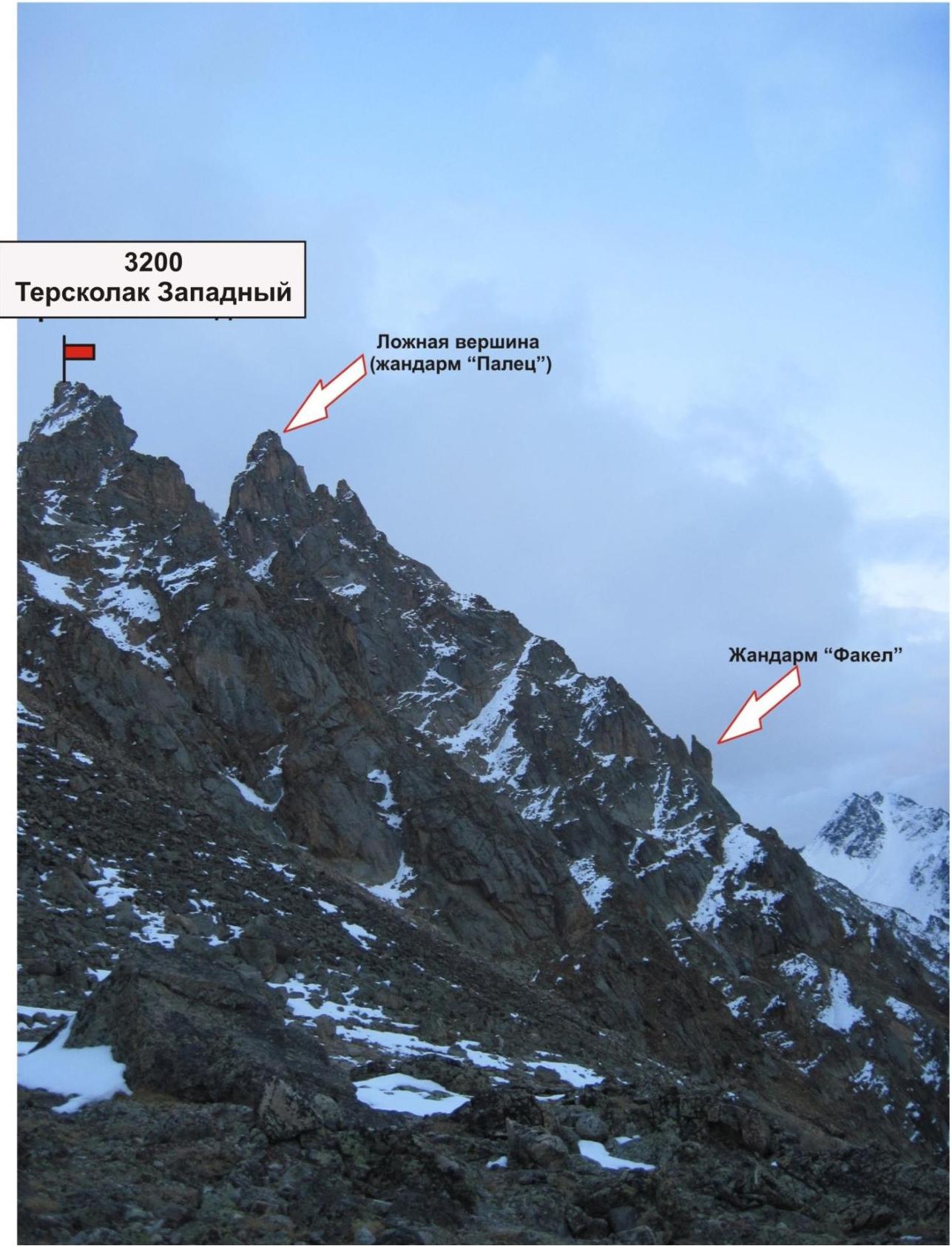
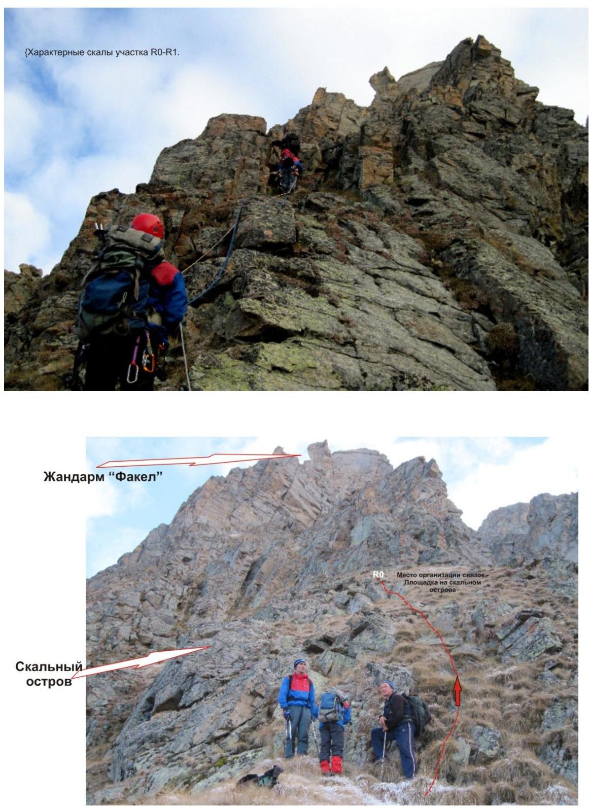
Gendarme "Torch" Section R6–R7. Passage of the inner corner,
then Section
R6–R7. Small key of the route. Traverse of the wall with approach under the
inner corner.
Section
R6–R7. Small key of the route. Traverse of the wall with approach under the
inner corner.