Ascent Passport
-
Technical climbing category.
-
Region 2.4, Caucasus, from Chiperezau pass to Gumači peak, Elbrus southwest spur.
-
Kyukyurtlyu (Kyukyurtlyu–Kolbashi), 4639 m, point 107, T. Lukashvili route 1981, via the center of the NW wall.
-
Rock route.
-
6B category of difficulty, seventh ascent.
-
Route characteristics:
- Route elevation gain — 590 m,
- Route length — 845 m,
- Length of sections with 5th category of difficulty — 310 m,
- Length of sections with 6th category of difficulty — 210 m,
- Average steepness of the main part of the route — 83°,
- Overall route steepness — 72°.
-
3 pitons left on the route.
Used on the route:
- bolted stationary pitons 80, including 52 for artificial anchors,
- removable bolted pitons — 16, including 9 for artificial anchors,
- total artificial anchors (AA) — 139.
-
Team's travel time — 59 hours, 10 days.
-
Leader Goryaev Anatoliy Erdnigorayevich — Candidate Master of Sports
Participants:
- Voronin Sergey Valeryevich — Candidate Master of Sports
- Slobodenyuk Yuriy Yuryevich — Candidate Master of Sports
-
Coach: Leonov Petr Georgievich
-
Departure to the route: September 7, 2000 at 3:00.
Summit reached: September 16, 2000 at 16:00. Descent to Terskol settlement at Elbrus rescue base: September 19, 2000 at 9:00.
-
Organizations:
- Dagestan Republican Search and Rescue Service, Ministry of Emergency Situations, Russia,
- Dagestan Alpine Federation.
2000, Makhachkala city
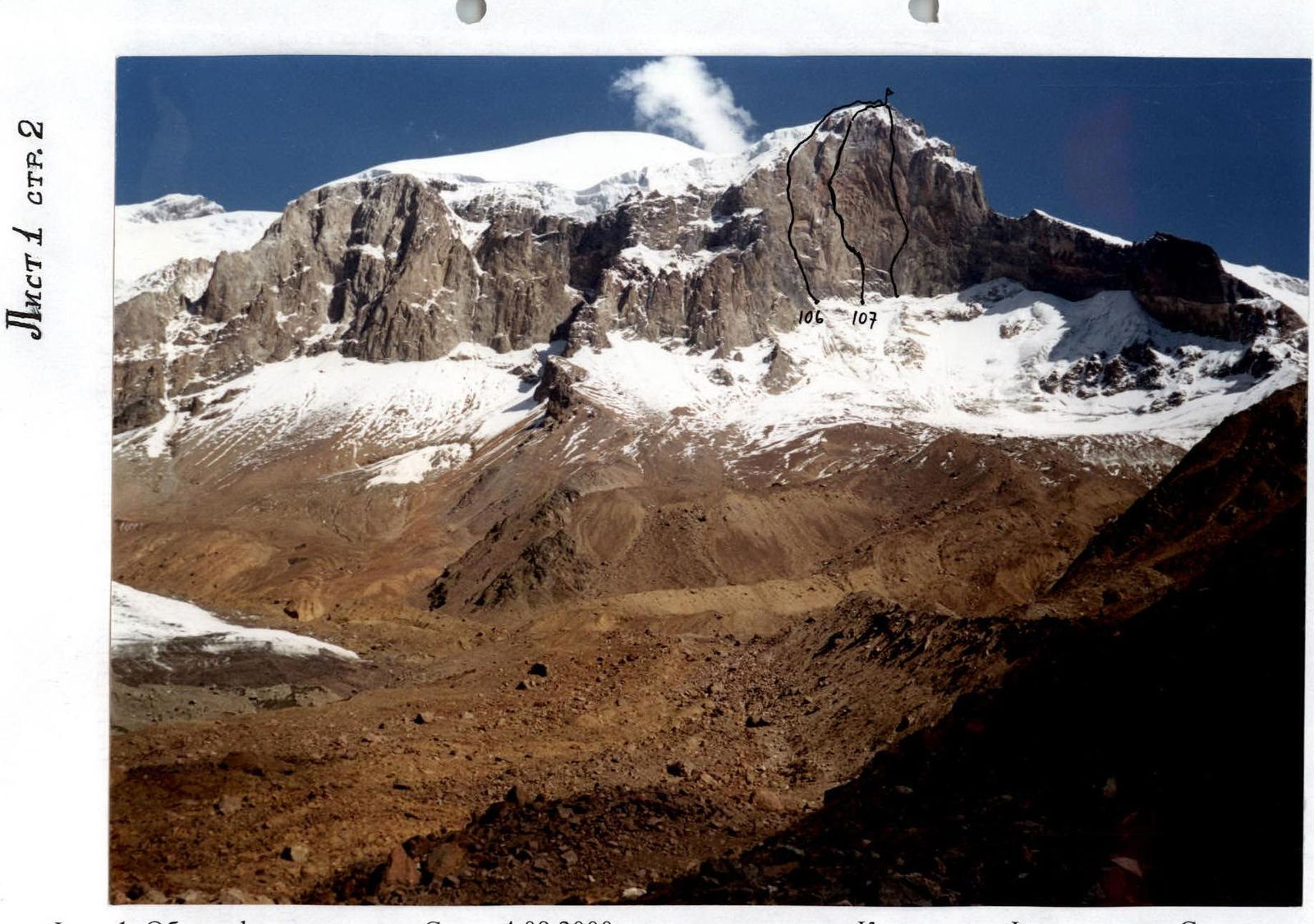
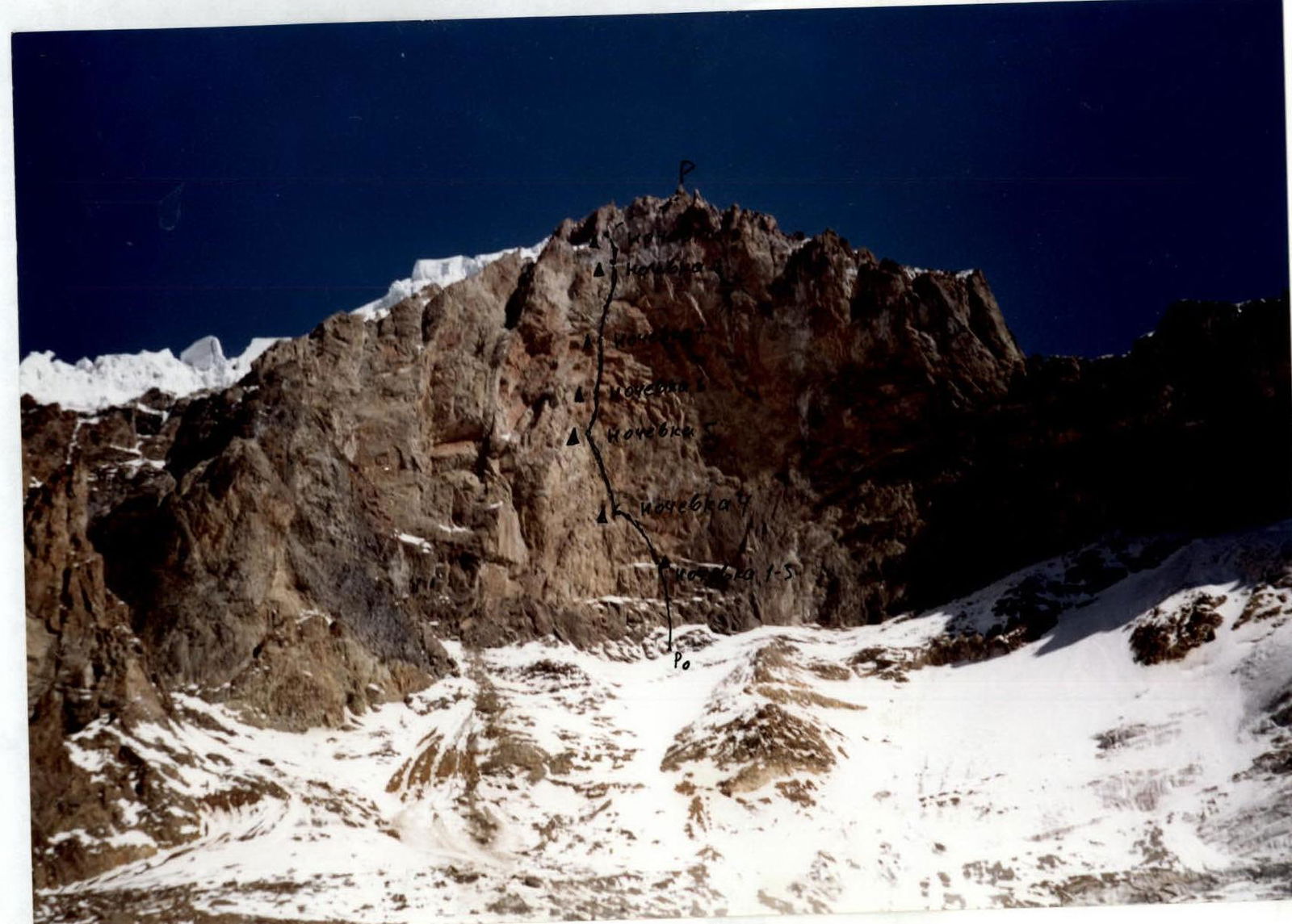
Photo 1. General photo of the peak. Taken on September 4, 2000 from the beginning of Kyukyurtlyu glacier. "Smena" camera. 106 — Giutashvili route 6A, 1974 107 — Lukashvili route 6B, 1981. To the right — Andreev route, first ascent 2000.
Climbing Area Overview
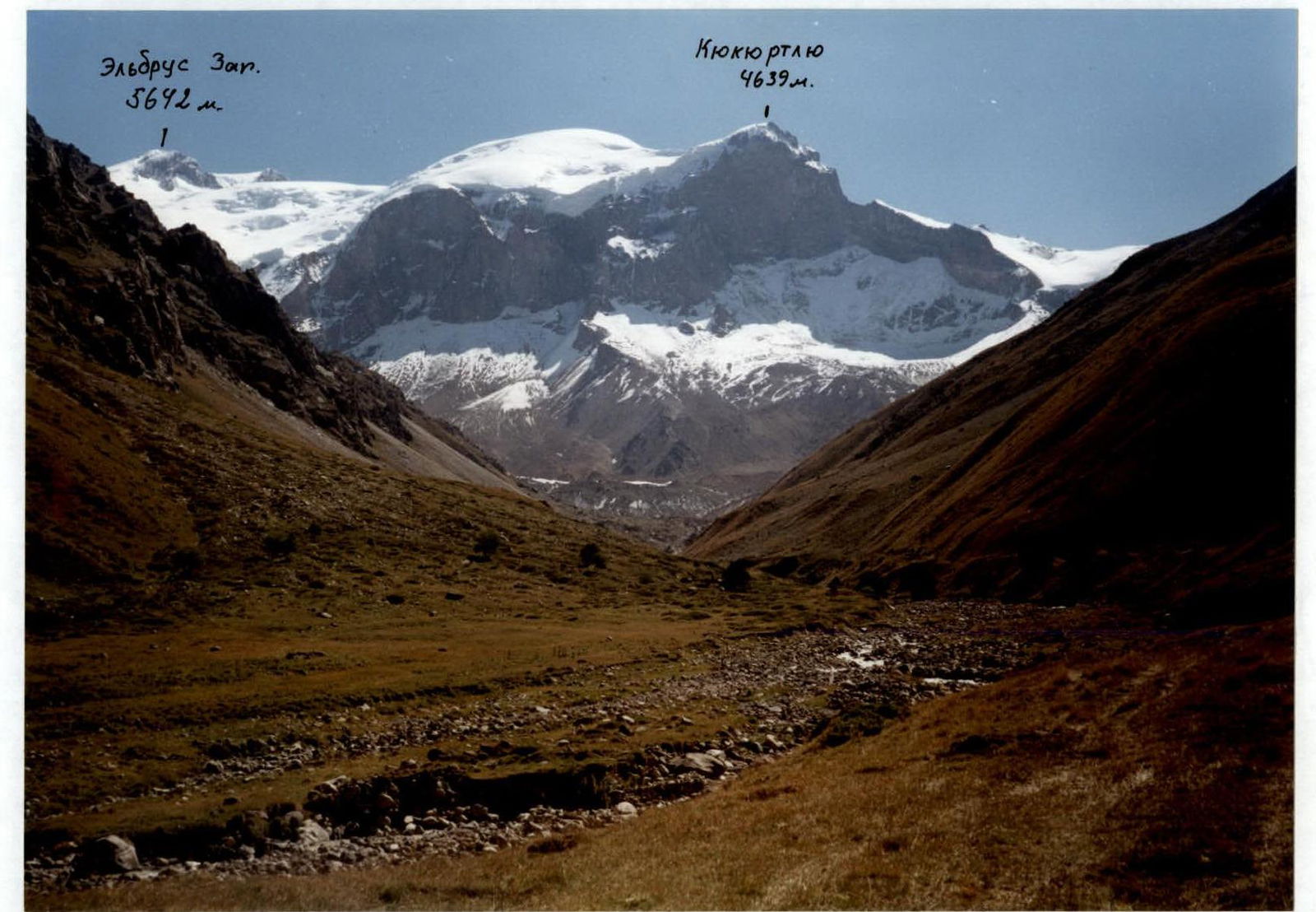
Kyukyurtlyu peak (Kyukyurtlyu–Kolbashi) is located in the southwest spur of Elbrus, 4.5 km from the Western summit. The peak and approaches are situated within the Karachay-Cherkess Republic of the Russian Federation. Although the peak is part of the Elbrus massif, it is quite remote for approaches. From the Baksan valley (from "Mir" station) through Khotyutau and Kyukyurtlyu passes, the approach takes 2 days.
Approaches:
- From Karachay-Cherkessia: from Karachaevsk city (1000 m) to Uchkulan village (1400 m) via asphalt road (55 km), then 5 km along the Ullu-Kam (Kuban) river valley to Khurzuk village (1450 m).
- Then turn left into the Ullukhurzuk valley, a right tributary of the Kuban, and proceed on a poor dirt road (15 km) across numerous bridges (about 12).
- After the Ullukhurzuk–BitikTebe fork (the road to sulfur springs turns left), the road becomes very poor, it goes along the left bank of Ullukhurzuk, gaining height above the river, and leads to the last Karachay koshu.
A convenient bivouac site: a large clearing, water, pine forest (2300 m).
Further route:
- From the bivouac site, ascend the valley along the left bank of Ullukhurzuk until the valley turns left (near Kurshou peak, 3690 m) — 2–2.5 hours.
- Shallow warm lakes, grass (2500 m), from here you can see (to the east) the Elbrus massif with Western and Southwest peaks, as well as the Southwest shoulder ("Dome") and Kyukyurtlyu peak.
- Continue along the valley to the tongue of Kyukyurtlyu glacier and along its left moraine to flat areas in the "pocket" of the moraine near Kebek pass (3000 m) — 2–2.5 hours.
- From the "pocket", ascend the moraine to the 3rd wall. Large-block talus, sometimes scree, after flattening — a site for ABC (3600 m) — 2–2.5 hours.
- From ABC, traverse the firn slope towards the wall, the steepness increases from 25° to 45° (under the wall). Enter the couloir and put on crampons. Ice protection via ice screws. The team set up ropes (4 ropes, 4). From ABC to the start of the route — 3 hours.
The start of the route is below the left edge of the arched ice shelf (4050 m).
Climbing area: 2.4, Caucasus. From Chiperezau pass to Gumači peak. The peak stands apart.
Main challenges:
- remoteness of the mountain,
- extensive glaciation around,
- cold wall,
- route start at 4000 m.
Although the wall is western (in the classifier — NW, which is incorrect), but due to its great steepness and the fact that the right part of the wall has a NNW exposure, the sun appears on the wall after 14:00 (in August). Due to the great steepness — problems with water, snow is only on one ledge in the middle part (leftmost) of the route (bivouac №3).
The area is known for harsh weather: vast ice fields of Elbrus cool the air, and after noon — cloudiness and snow. The western wall of Kyukyurtlyu is the first to meet the moist air masses from the Black Sea.
The ascent is complicated and made psychologically tense by:
- partially destroyed rocks, especially in the upper part.
- the wall is composed of volcanic rocks like tuff, which are easily susceptible to weathering.
- the need to carry ice climbing gear: crampons, ice axes, ice screws, etc.
The approach to the wall is challenging: bare ice with a steepness of 45°; the upper part of the route — a groove and an ice wall with glassy ice. All this makes the load heavier.
The route is classified as a rock route. It is necessary to bring a tent for bivouacs on Elbrus ice fields at altitudes around 5000 m, as the descent from Kyukyurtlyu goes through the Southwest shoulder "Dome". The descent from the Dome goes to Khotyutau pass, across Perevalny glacier. From the pass, the return path to Ullukhurzuk valley is long: via Kyukyurtlyu pass.
All this makes T. Lukashvili's 1981 route on Kyukyurtlyu the most challenging in the technical category in the Caucasus and very rarely visited. This ascent required organizing a full-fledged expedition, and within 16 years after the first ascent, our team was the fifth. The previous ascent was made by instructors from "Shkhelda" alpine camp in August 1993 (Sushko S. E. + 3). And over the past 19 years, our team was the seventh, and we managed without a support group, which was done for the first time on this route.
Route description:
- The route begins below the left edge of the characteristic curved ice shelf in the lower part of the wall (4050 m), approach to the wall via a wide ice couloir (200 m, 40–45°).
- About a hundred meters to the left, someone's rope is hanging.
- Section R0–R1 on September 7, 2000, was a snowy couloir with a "wall" in the middle. It should be noted that an unusually warm summer and bad weather at the beginning of autumn significantly changed the snow and ice sections of the route.
- Further, according to the description, to the left, but we went straight up, along the right vertical wall of the internal angle on artificial anchors (section R1–R2), then along the internal angle to an inclined shelf (4130 m). According to the description, the section took two "ropes".
- Having reached the right part of the shelf (bivouac), further up, a bit to the right of the usual path.
- On section R3–R4, no traces from previous groups, except for a fresh rappel loop on a loose bolt and a "friend", then up the angle, everything "goes".
- In the middle of section R5–R6, a horizontal ledge (niche) for two is equipped with bolts under a cornice.
- At station P4 — "Pecel" bolts and loops from Abramov's group.
- Then a bit up and left 15 m. Here is control cairn №1 (replaced the can and rope) and bivouac.
- Upwards is an internal angle. Along its left wall to the edge, along the ridge up, back into the angle, and onto an inclined slab, along it up and right under the wall, here P6.
- Section R9–R10 is entirely on artificial anchors, its second part, steeper, without relief, is drilled with bolts.
- From station P7, several difficult meters along the angle, then it flattens out to the left, up, traverse. In the middle — a small wall, a crack with good climbing, but for reliability, it was passed on artificial anchors.
- From station P8, another 15 m of traverse, and a chimney with a cork begins. According to the description, it is bypassed on the left behind the angle, but we passed it "head-on".
- Further, the angle "subsides" and does not present a particular difficulty.
- Then comes shelf P9. An empty can from a control cairn hung on a "carrot", we left our note. Bivouac here.
- After bad weather, the shelf was not just "irrigated" with water, but at 17:30, a real waterfall started, until 20:00.
- Further to the right along an inclined slab, the beginning is steep. Two ropes are hanging: one very old, one modern, from Kaliningrad, from Abramov's group (logically), cut through.
- P10 — at the base of overhanging walls, bivouac.
- Upwards — a bolted route, 60 m. At station P11, remnants of a hammock and a platform from the 80 cm's.
- Then the monolith ends, and half a rope is a rather complex slippery climbing, to the right and left, "cornice" and to the left and right to P12. Bivouac here (bad weather).
- Further to the right and up, into the angle, slippery, crumbly underfoot. Up the angle, at the exit — artificial anchors.
- Then to the right, along weakly held rock to a ledge P13, at the station — two "Pecel" bolts.
- Further straight up the wall, onto a ledge, bivouac. The rope was enough to pass another 25 m.
- Inclined slab with good cracks, but many blocks are not supported from below, it's hard to determine what they're resting on, especially at the end of the section.
- Further up, an internal angle, along its right wall, then along the angle, to the flattening, bivouac (bad weather).
- Ten meters to the left and up (unstable structure, but didn't cause big problems), to the last (as we thought) rock station (here old galoshes still hang).
- Further to the left into the couloir. Instead of glassy ice, according to the description, we encountered a rather complex, without holds, dry wall.
- Then two ropes of ice along the couloir, and further, instead of the promised snow — comparatively complex, disintegrated two ropes of iced rocks.
- On the last 60 meters, on the contrary, there was waist-deep snow, cornices, fog.
On the summit — a memorial plaque.
Descent:
- From the summit in the direction of Elbrus below at 4600 m — bivouac.
- Further to the southwest shoulder 4900 m — bivouac (bad weather).
- Then down towards Big Azau glacier.
- Further, crossing glaciers to the left, down to the cable car station "Old Panoramic" in Terskol settlement.
Sheet 3, page 5. Photo 2. Photopanorama of the area. Taken on September 4, 2000 at 11:30 from Ullukhurzuk valley, "Smena" camera.
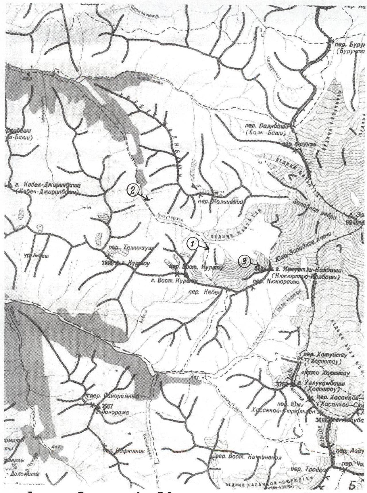
Sheet 3, page 6. Area map.
Ascent Schedule
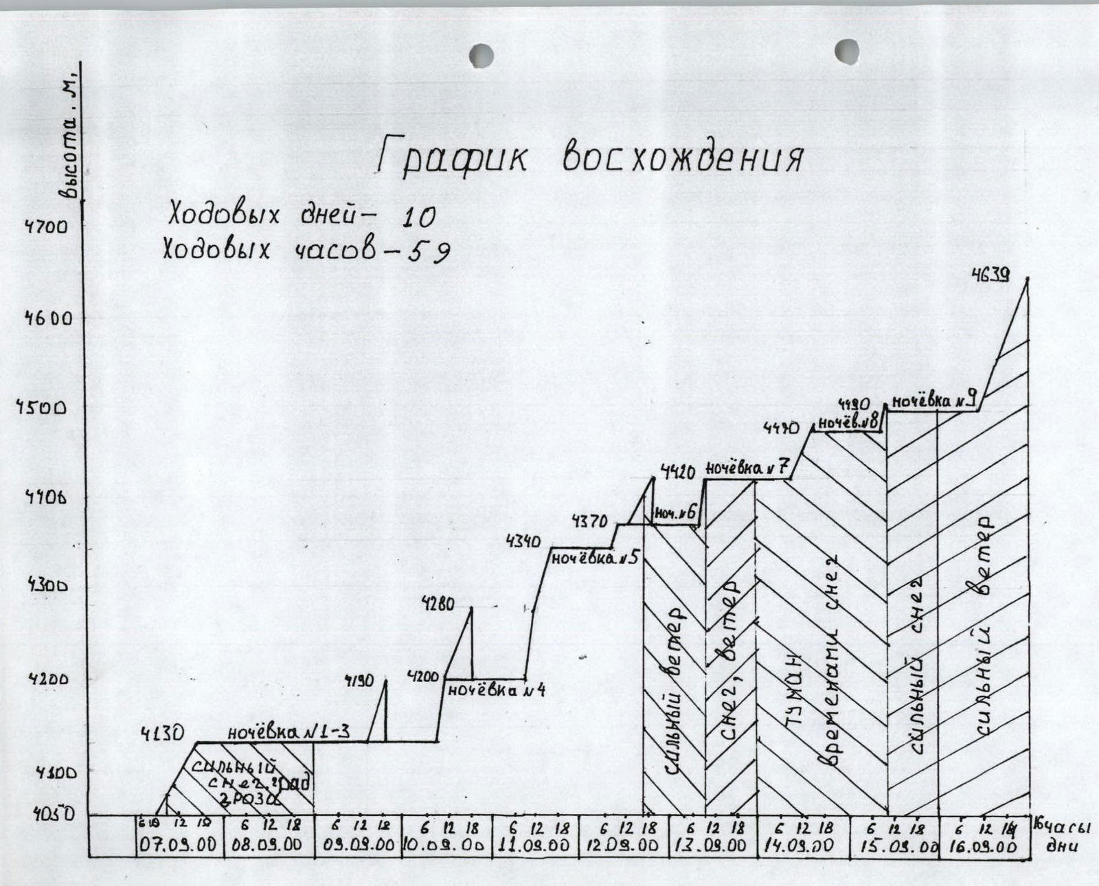
Sheet 4, page 6. Travel days — 10 Travel hours — 59 Height, m 4700 4600 4500 4400 4300 4200 4100 4050 07.09.2000 08.09.2000 09.09.2000 10.09.2000 11.09.2000 12.09.2000 13.09.2000 14.09.2000 15.09.2000 16.09.2000 Days Hours 4639 m 4490 m Bivouac №9 4470 m Bivouac №8 4420 m Bivouac №7 4370 m Bivouac №6 4340 m Bivouac №5 4280 m 4200 m Bivouac №4 4130 m Bivouac №1–3 Snow, hail. Strong snow, hail. Strong wind Snow, wind Fog Occasional snow Strong wind Strong snow
Route Diagram for 6 YAA Participants
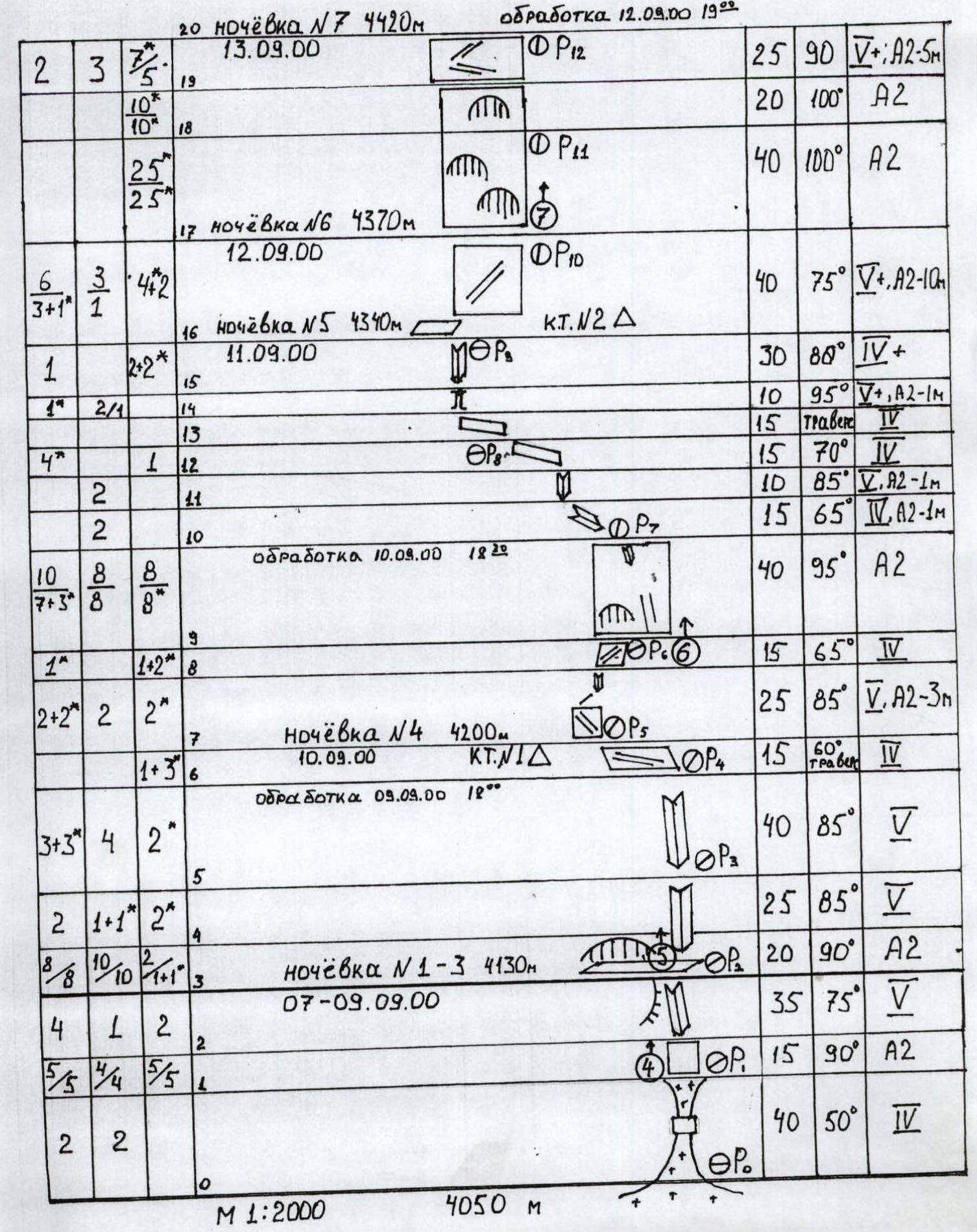
Sheet 5, page 7. 20. Bivouac №7, 4420 m, 13.09.2000. Processing on 12.09.2000, 19:00. P12: 25 m, 90°, V+, A2-5M 19. P11: 20 m, 100°, A2 18. P11: 40 m, 100°, A2
-
Bivouac №6, 4370 m, 12.09.2000. P10: 40 m, 75°, V+, A2-10M
-
Bivouac №5, 4340 m, 11.09.2000. Control cairn №2. P0: 30 m, 80°, IV+
-
P1: 10 m, 95°, V+, A2-1M
-
P8: 15 m, traverse, V
-
P8: 15 m, 70°, V
-
P7: 10 m, 85°, V, A2-1M
-
P7: 15 m, 65°, V, A2-1M
-
Processing on 10.09.2000, 18:20. P6: 40 m, 95°, A2
-
P6: 15 m, 65°, IV
-
P5: 25 m, 85°, V, A2-3M
-
Bivouac №4, 4200 m, 10.09.2000. Control cairn №1. Processing on 09.09.2000, 12:00. P4: 15 m, 60°, IV
-
P3: 40 m, 85°, V
-
P2: 25 m, 85°, V
-
Bivouac №1–3, 4130 m, 07–09.09.2000. P2: 20 m, 90°, A2
-
P1: 35 m, 75°, V
-
P0: 15 m, 90°, A2
-
P0: 40 m, 50°, IV M 1:2000 4050 m
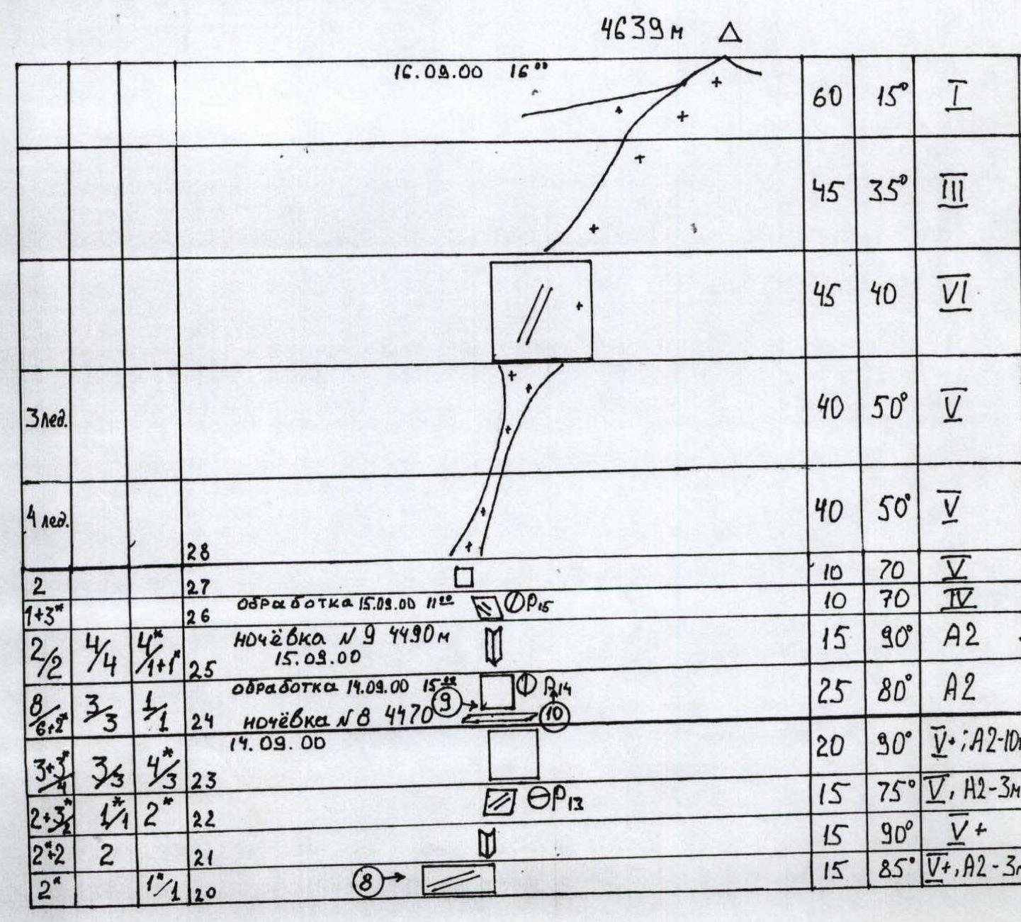
Sheet 6, page 8. Travel days — 10 Hours — 59 Pitons used:
- rock — 89
- chocks — 57
- bolts — 96
- ice — 7
4639 m 16.09.2000 16:00 3 ice. 60 m, 15°, I 45 m, 35°, III 45 m, 40°, V 40 m, 50°, V 14 ice. 40 m, 50°, V 28. P15: 10 m, 70°, V 27. P15: 10 m, 70°, IV Processing on 15.09.2000, 11:00. 26. Bivouac №9, 4490 m, 15.09.2000. P14: 15 m, 90°, A2 25. P14: 25 m, 80°, A2 Processing on 14.09.2000, 15:00. 24. Bivouac №8, 4470 m, 14.09.2000. P13: 20 m, 90°, V, A2-10M 23. P13: 15 m, 75°, V, A2-3M 22. 15 m, 90°, V+ 21. 15 m, 85°, V+, A2-3M 20.
Sheet 7, page 9. Photo 3. Technical photo of the route, taken on September 6, 2000 at 15:00 from ABC, "Smena" camera. Sheet 7, page 10. Notes from the route.

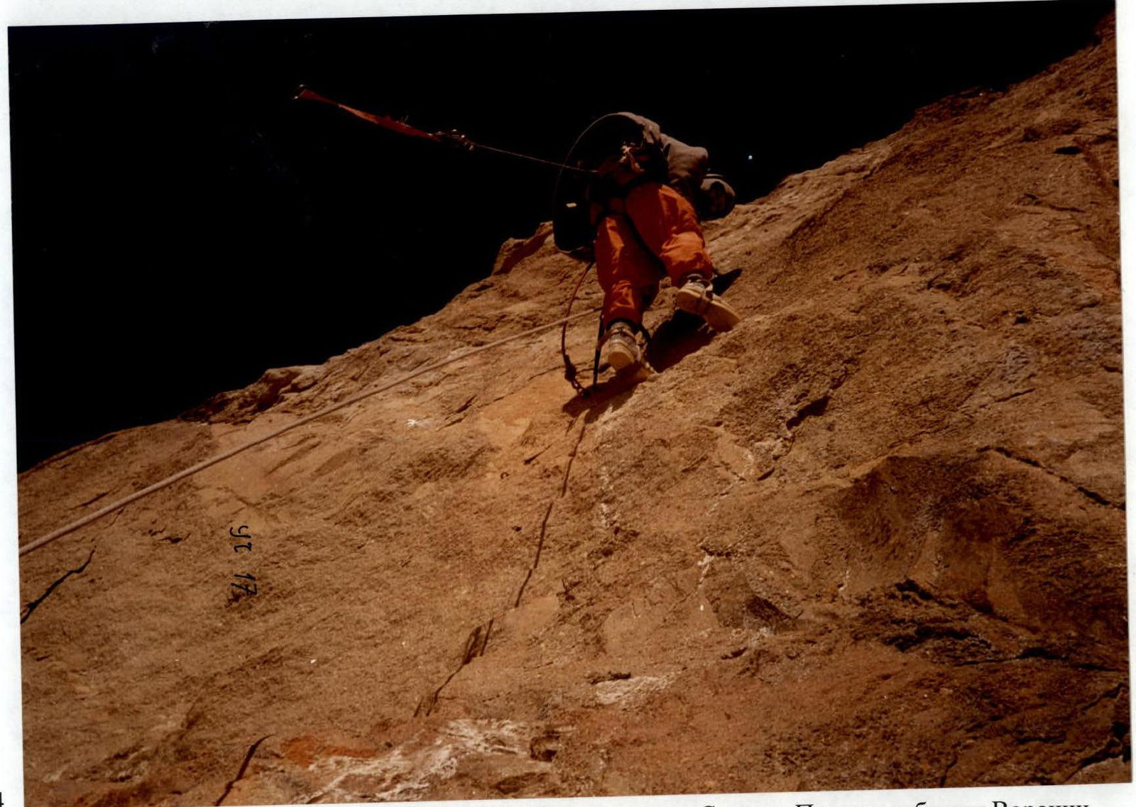
Sheet 10, page 13. Photo 6. Passing the R9–R10 section on ropes. Taken from P6 on September 10, 2000 at 16:00, "Smena" camera. Goryaev is on the station, Voronin is on the ropes.
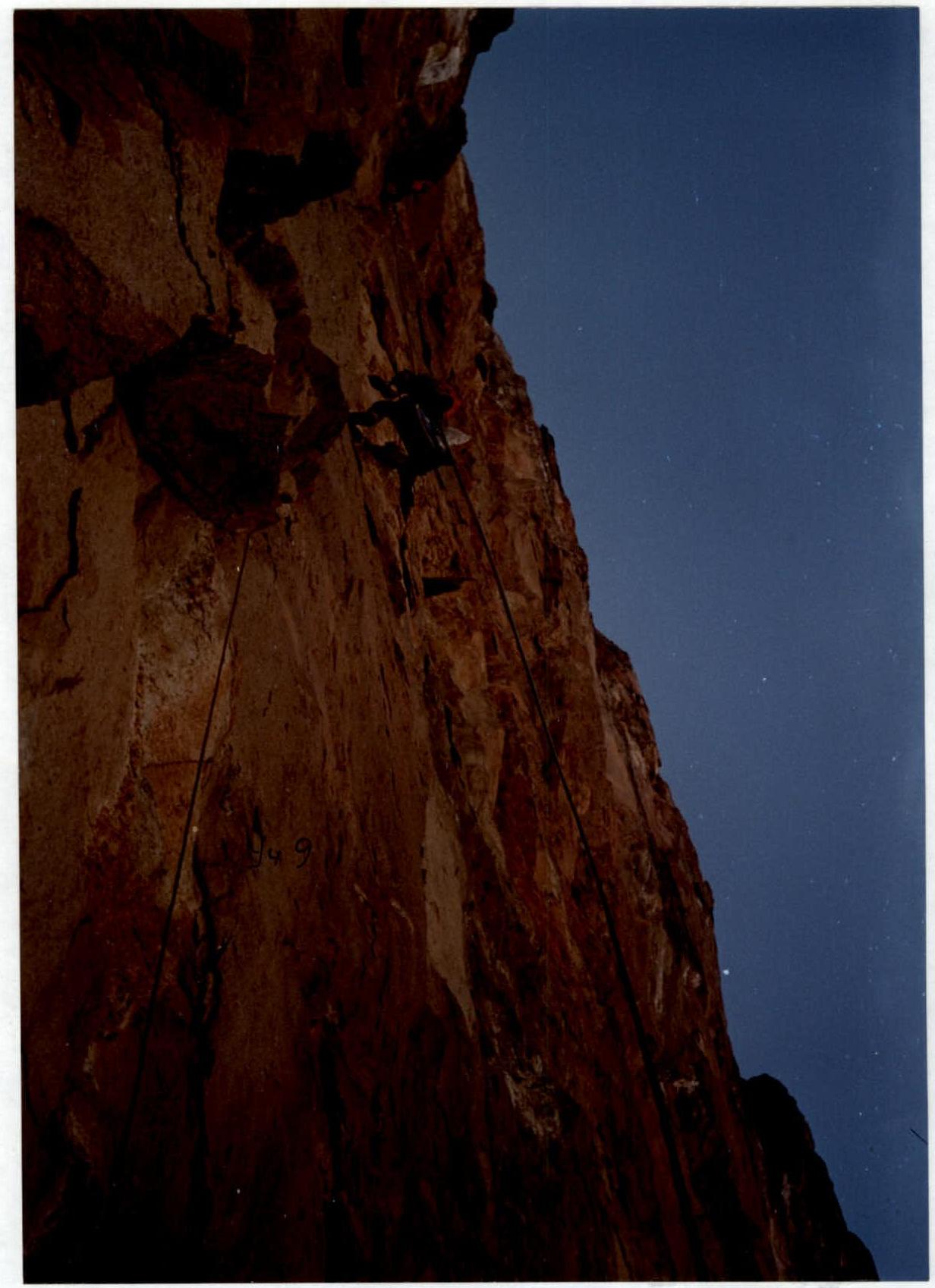
Sheet 8, page 11. Photo 4. Passing the R1–R2 section. Taken from P0 on September 10, 2000, "Smena" camera. Voronin is working first.
Sheet 11, page 14. Photo 7. Processing the R17–R18 section. Taken from P10 on September 12, 2000 at 15:00, "Smena" camera. Voronin is working first.
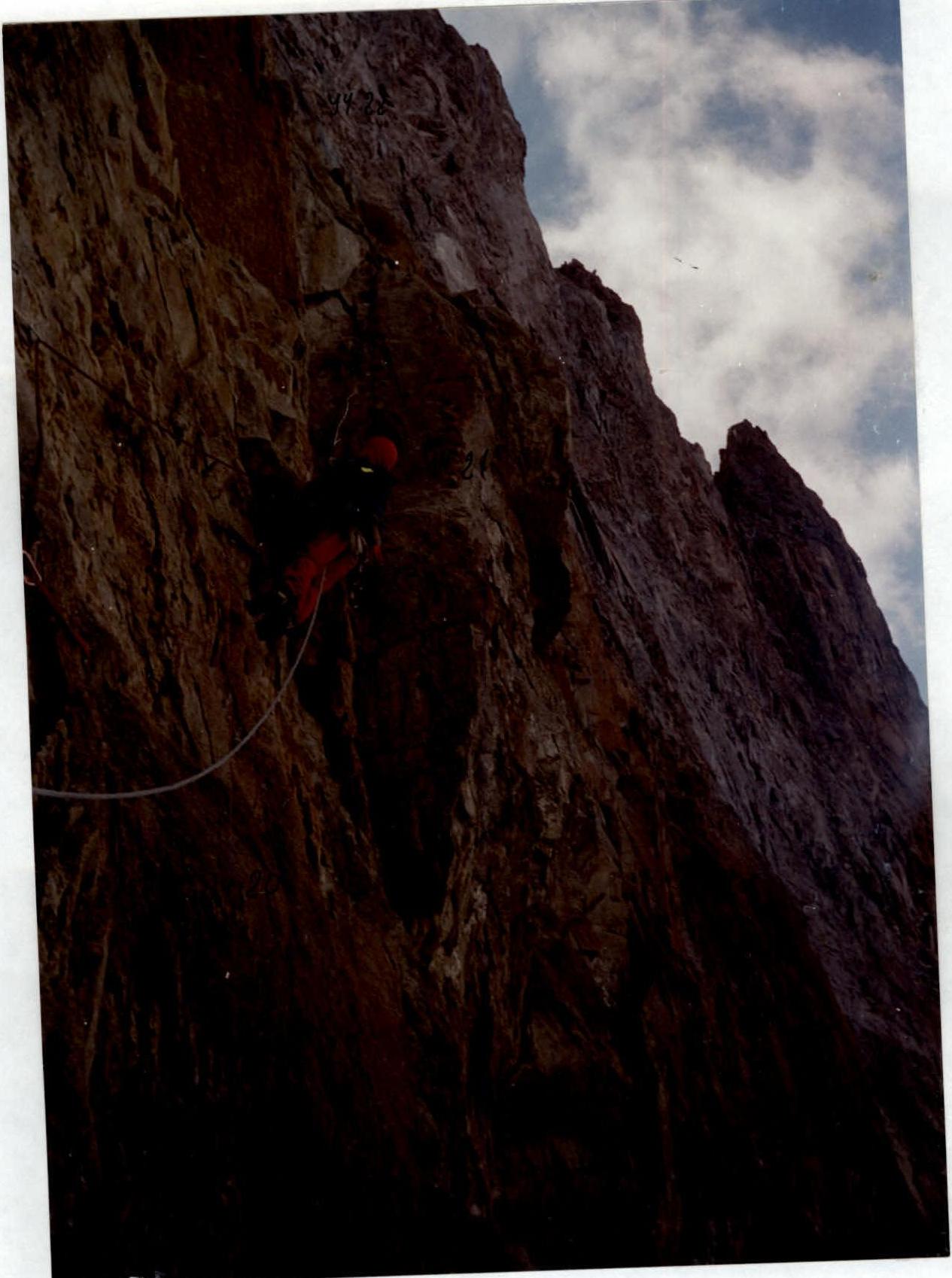
Sheet 12, page 15. Photo 8. Passing the R20–R21 section. Taken from P12 on September 13, 2000 at 9:30, "Smena" camera.
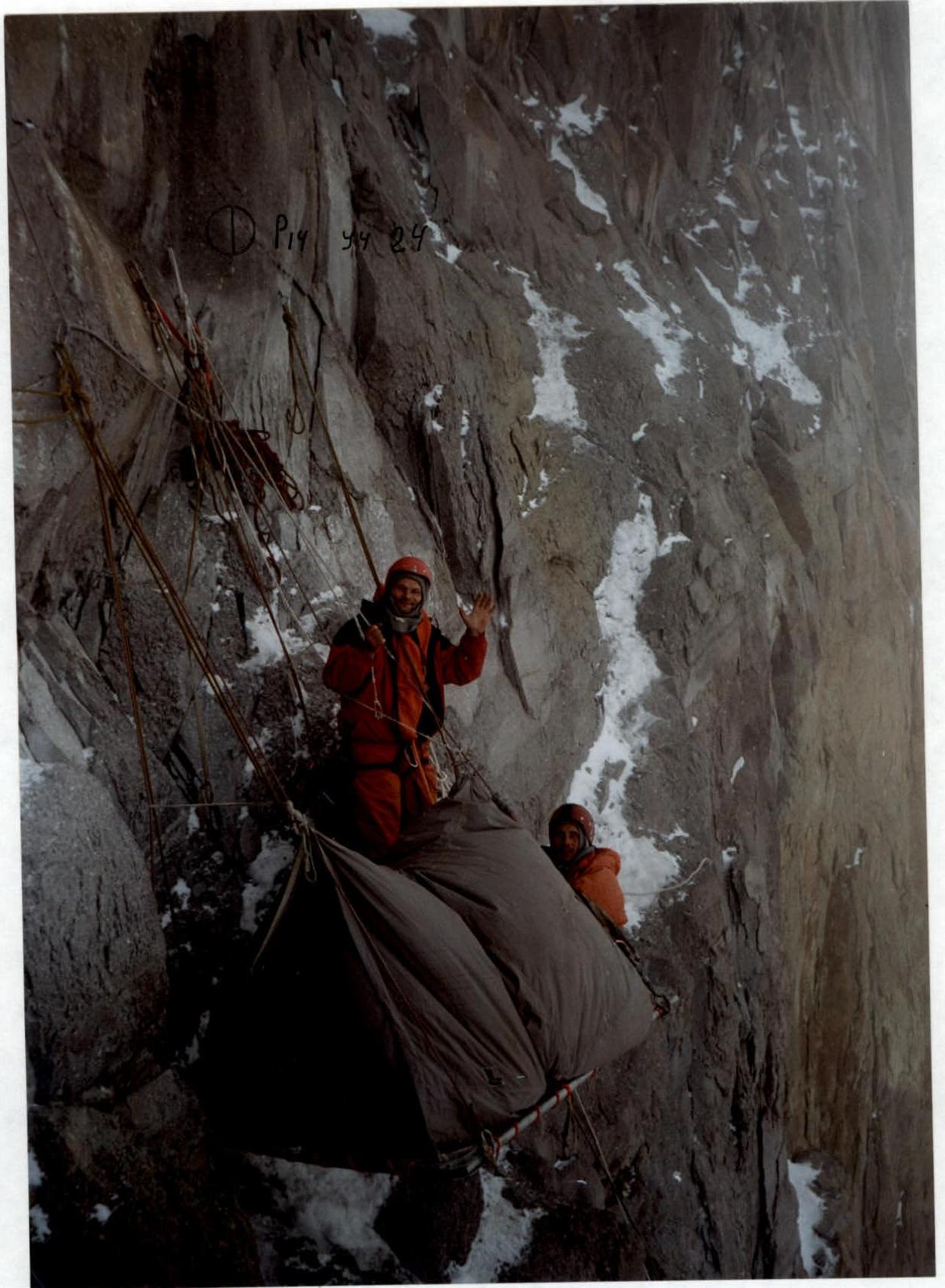
Sheet 13, page 16. Photo 9. Bivouac №8. Start of section R24. Taken on September 14, 2000. Slobodenyuk and Goryaev on the platform.
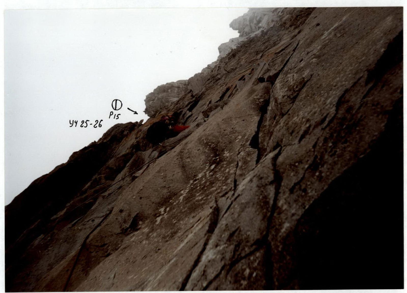
Sheet 14, page 17. Photo 10. Passing the R25–R26 section.