CENTRAL CAUCASUS. ADYR-SU VALLEY ALPINISM CAMP “DJAILYLYK”
V. Cheget-Tau Chana from the east via the wall. (Route description of the first ascent)
Group: DAVYDOV A.P. — leader
- VYSHINSKY N.N.
- PLYUKHIN Y.V.
- SUKHORUKOV A.T.
August 1963
The Cheget-Tau Chana peak is located in the Main Caucasian Range. The ridge of the Cheget-Tau massif, enclosed between the peaks of Latsga and Gumachi, stretches from southeast to northwest. The ridge is weakly dissected and has an insignificant number of "gendarms". The highest point of the massif has an elevation of 4102 m and is located in its northwestern part — the Main summit. The southeastern part of the ridge has some dominance over the adjacent ridges and can be considered its Eastern summit.
From the Main summit to the northwest to the peak Gumachi, a ridge descends, the ascent along which (through peak Gumachi) is classified as a 2A category route. The route along the rocky rib extending to the north is classified as 4A category. The route along the northeastern rib (usual) is classified as 3A category (ascent along this rib followed by a traverse through peak Latsga — 3B category). Between these ribs, there is another counterfort, along which an ascent from the Gumachi glacier is possible, classified as 3A category.
To the Eastern summit from the southeast, a ridge adjoins, from which two ribs extend: to the southeast and northeast. Along the northeastern rib (according to Yu.I. Chernoslivin), an ascent was made by a group led by Vinyakov.
Between these ribs lies the eastern wall, which became the object of ascent for the group of instructors from the "Djailylyk" alpine camp.
Group composition: DAVYDOV A.P. — 1st sports category — leader, VYSHINSKY N.N. — 2nd sports category — participant, PLYUKHIN Y.V. — 1st sports category, SUKHORUKOV A.T. — 1st sports category.
On the eve of the day of the ascent, a duo consisting of Davydov and Sukhorukov went under the start of the route and spent 1.5 hours familiarizing themselves with possible route options. The main landmarks on the route were identified.
Leaving the bivouac located at "Cheget overnight stays" at 3:30 AM, the group moved along the glacier towards the Garvash pass and reached the start of the route in 35 minutes. Here, the group roped up.
From the east, a rocky chute and two snowy couloirs with avalanche debris descend onto the glacier. We start the ascent via the first, widest one, crossing the bergschrund at the most convenient spot. Above the bergschrund, we ascend a snowy slope with a gradient of about 35° for 60–80 m directly upwards towards the rocky outcrops. The movement is straight up towards the clearly visible outcrops of grey rocks on the wall and a black spot (to the right of them).
Above the snowy slope, the path passes through simple rocks along ledges and small snowfields to the nearest landmark — a protruding rocky outcrop, which is accessed via a ledge and a crack to the right (in the direction of travel). The length of this section is about 180 m. The average steepness is 40–45°. The first control cairn was built on the rocky outcrop.
From the control cairn, we move along a ledge to the right (about 20 m) and then up a small couloir to the left towards the base of the main wall (approximately 40 m above the first control cairn).
The lower part of the wall consists of smooth monolithic rocks resembling "sheep's foreheads," with a steepness of more than 50°, and few holds and cracks. The cracks are shallow. We move up the wall, initially deviating 2–3 m to the left along a small ledge, and then continue straight up for about 30 m. Here, 3 pitons are hammered in. Further ascent is to the left towards a vertical internal angle. The rocks in the angle are destroyed. The length of the angle is more than 50 m. Having ascended about 30 m along the angle, we move to its left side (in the direction of travel) onto a small ledge and then upwards for 5–7 m to a small ridge. The protection on this section is piton-based (3 pitons) and through a protrusion when exiting onto the ridge.
Further, a smoothed wall with few holds and cracks for pitons extends straight up. The wall has several small inclined balconies where protection can be organized for the following climber through a piton. Here, the steepness of the slope reaches 70°.
Moving straight up with piton protection for about 70–80 m (7 pitons), we exit to the upper part of the wall to the right, beyond a small bend, onto an inclined ledge.
Continuing along this ledge further to the right into the couloir is not recommended due to the risk of rockfall.
From the inclined ledge, straight up along a small crack-chimney, we exit onto steep rocky slopes with many holds. After 50–60 m, the slope turns into steep slabs. Along the slabs, for about 30 m (3 pitons), we exit onto a small shoulder and then along an internal angle (to the left in the direction of travel) and destroyed rocks straight up (20–30 m) onto the next rocky shoulder.
On this shoulder, the second control cairn is established.
From the second control cairn, we move straight up towards a clearly visible rocky tower along rocks of medium difficulty (20–30 m). We exit onto the tower from the right (in the direction of travel) along steep smoothed rocks (15–20 m). In the upper part of the rocks, there is a small overhang. The exit from under the overhang is to the right along a small ledge, then an ascent up a 3-meter wall along a crack onto a scree slope and further onto the tower. The protection is piton-based (4 pitons).
From the tower upwards, a strongly destroyed rocky ridge extends, along which we exit onto a "gendarme" on the main ridge of Cheget-Tau Chana (about 90 m). Here, the movement involves simultaneous, sometimes alternate, protection. On the "gendarme," the third control cairn is left.
Further, along a snowy ridge and a rocky ascent onto the next shoulder and the Eastern summit. Then along the ridge to the Main summit via the usual route (counter-movement) with a further descent onto the Gumachi glacier through peak Gumachi and then to "Cheget overnight stays".
Time breakdown
"Cheget overnight stays" — start of the route under the bergschrund — 35 minutes.
Passing the bergschrund, snowy slope, and rocky ledges — to the first control cairn — 1 hour 45 minutes.
From the first control cairn to the second — 6 hours.
From the second to the third control cairn — 2 hours.
From the third control cairn to the Main summit — 1 hour 30 minutes.
Descent from the Main summit to the overnight stays — 3 hours 10 minutes.
The total time for the route was about 15 hours of work.
Possible overnight stay locations
- There are no convenient places for overnight stays on the wall.
- In some places, it is possible to organize a sitting bivouac.
- When exiting the wall onto a small shoulder or near the second control cairn, it is possible to set up one tent.
- On the rocky tower before exiting onto the main ridge, there is also a convenient place for setting up a tent.
Remarks on the route
It is necessary to start the ascent as early as possible, before the sun illuminates the slope (before sunrise). After sunrise, crossing the bergschrund and the first snowfield is not recommended due to the risk of rockfall.
The remaining part of the route is relatively safe from accidental rockfall and completely safe from possible avalanches from the northeastern rib and slope.
Entering the left snowy couloir is not recommended due to the high risk of rockfall and avalanche danger.
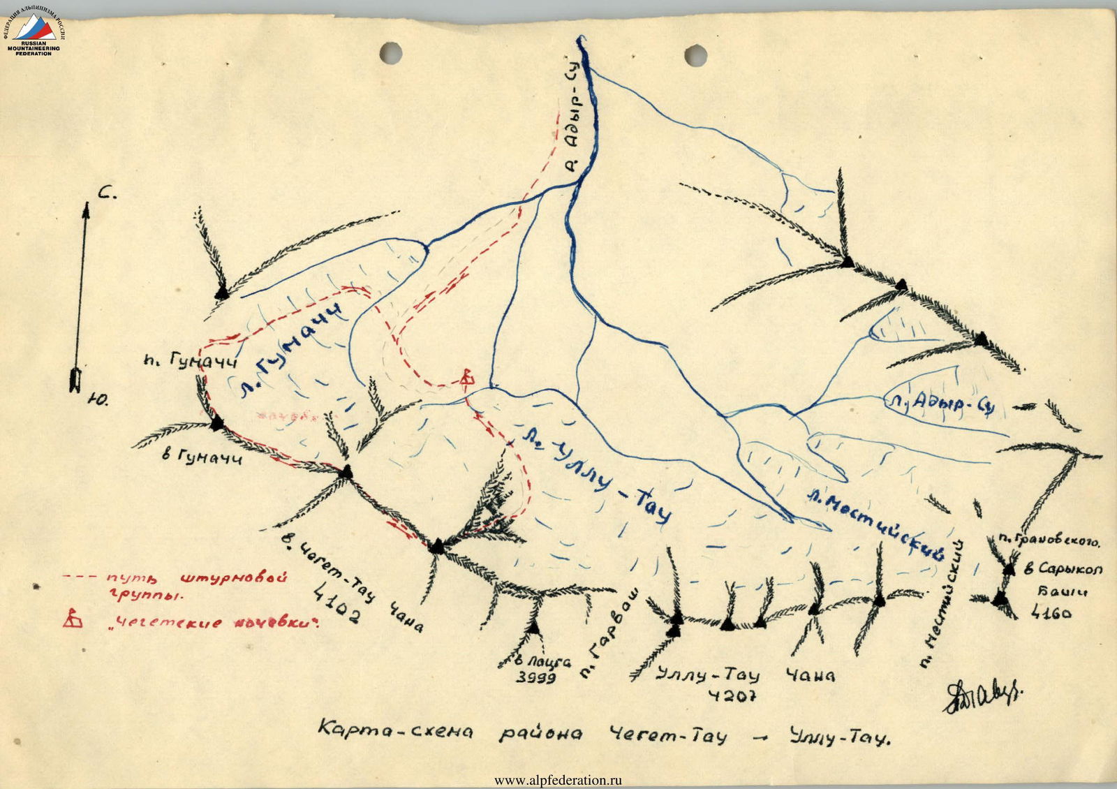
Map-scheme of the Cheget-Tau – Ullu-Tau area.
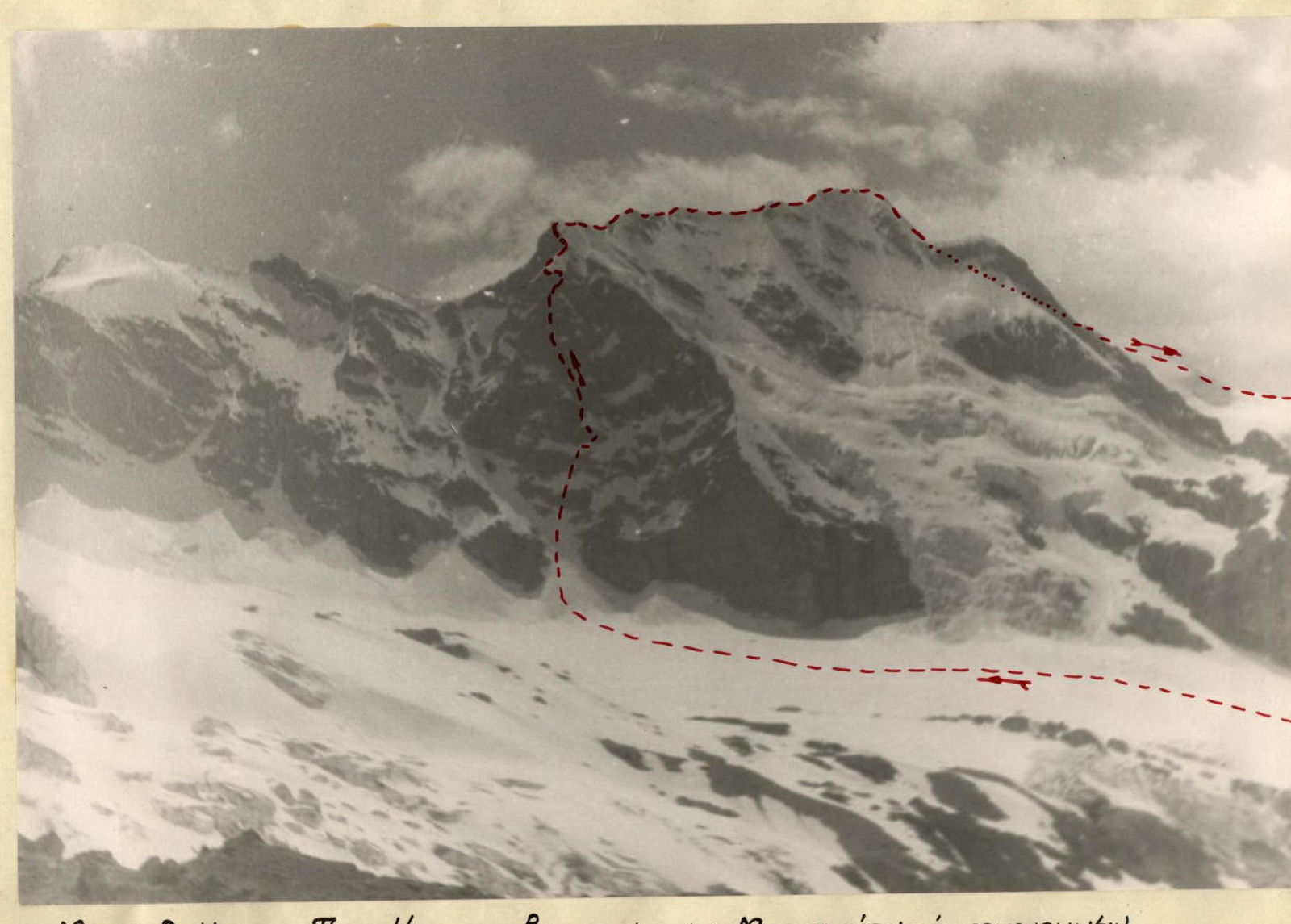
Cheget-Tau Chana massif from the east
Cheget-Tau Chana massif from the east (from the Mestia refuge).
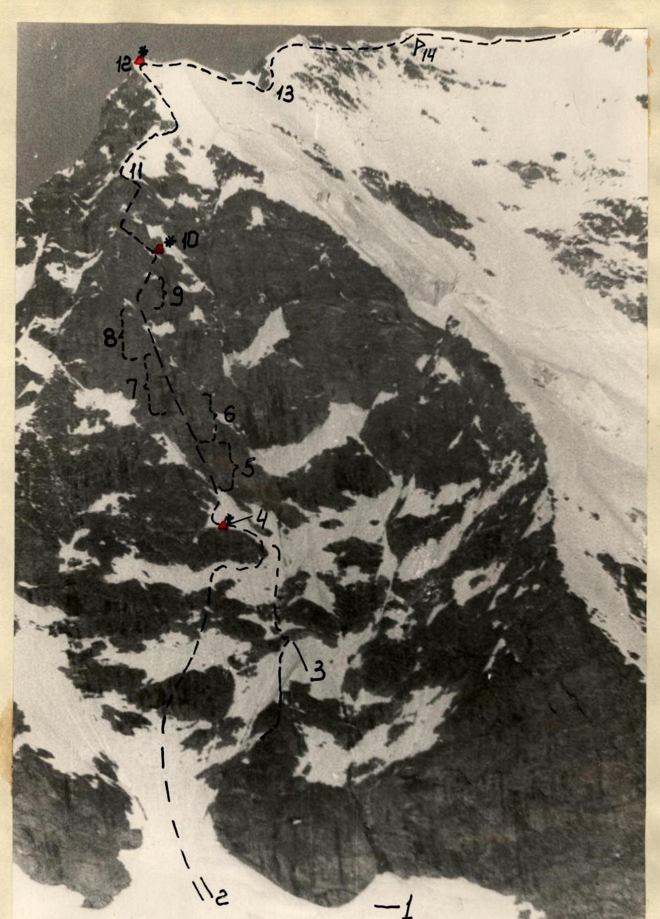
Eastern wall of Cheget-Tau Chana peak
- Rocky chute.
- Snowy couloir.
- Rocky ledges with small snowfields.
- 1st control cairn.
- Monolithic rocks resembling "sheep's foreheads".
- Vertical internal angle.
- Wall with small balconies.
- Rocks of medium difficulty.
- Steep slabs.
- 2nd control cairn on a small shoulder.
- Tower.
- 3rd control cairn.
- Pre-summit ridge.
- Eastern summit.