
Report
On the ascent of Mestia-Tau peak via the Southern counterfort, category 4B (approximately)
Mestia-Tau peak is located in the upper part of the Lekzyr massif, in a spur of the Main Caucasian Ridge extending from the Western peak of Sarykol-Bashi. From Mestia-Tau peak, a snow-ice ridge descends westward to the Mestia Pass plateau, classified as a category 1B route. To the north, a ridge leads to the Western peak of Sarykol-Bashi and is part of the traverse of these peaks via a category 2A route. The eastern slopes of Mestia-Tau peak feature very steep and deteriorated rocks, interspersed with small ledges. To the south, the peak initially gives way to a narrow and gentle snow ridge leading to the "Uzlovoĭ" gendarme, which then drops off southward with a rocky triangular wall. The middle part of this wall forms a pronounced rocky ridge. The route along the Southern ridge is logical and safe. This route can be recommended for the ascent of sports groups at the 5th training stage located in the vicinity of the Lekzyr glacier.
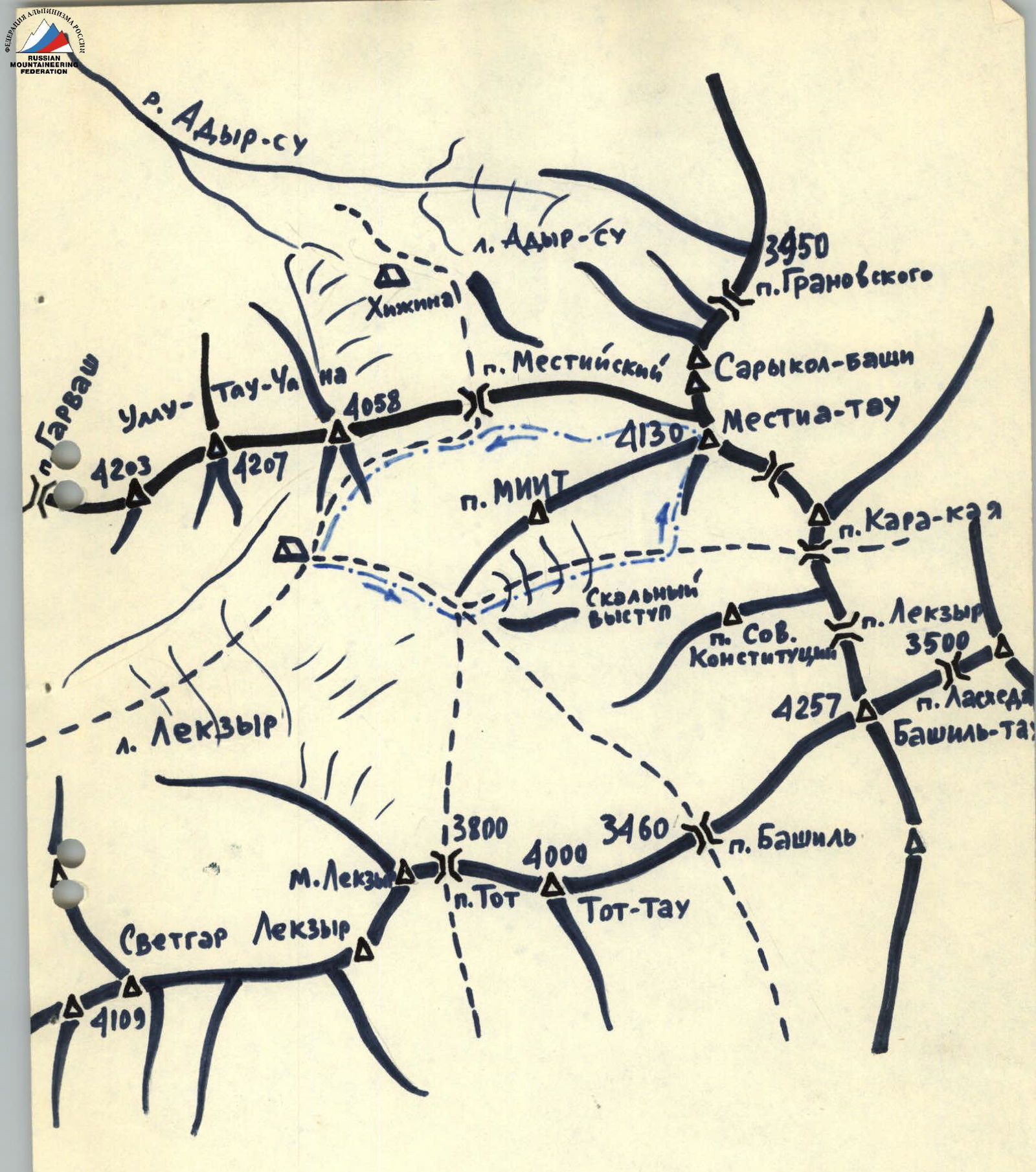
Map of the Lekzyr glacier area. Group's route. Tourist trails. The base camp of the Dzhaĭlyk alpine camp разрядников was situated on the right (orographic) upper lateral moraine of the Lekzyr glacier, beneath the slopes of the eastern peak of Ullu-Tau.
Route Description
From the base camp, the path proceeds up the Lekzyr glacier along its right (orographically) edge, circumventing the slopes of MIIT peak from the south. Then, a 30–40° ascent leads to a large snow-firn plateau. The path across this plateau proceeds leftward along the slopes of the peak, which the first ascenders of the Dzhaĭlyk alpine camp named peak Sovetskoy Konstitutsii in honor of the adoption of the new USSR Constitution. Crossing the firn plateau toward the Southern wall of Mestia-Tau peak, one must approach the base of the Southern ridge (section R0).
In the middle part of the ridge, a large bastion of reddish color stands out. The exit to beneath this bastion's wall follows simple rocks at the lower part of the ridge (section R1). Depending on snow conditions and the time of year, it is advisable to bypass the very lower part of the ridge via snow on the left (steepness 30–40°). Movement along the ridge to the wall (section R1) is simultaneous, with rope placements around numerous protrusions. The deteriorated rocks of this ridge alternate with sections of monolithic, moss-covered large blocks. The final 40 m before the wall proceed along a very sharp but gentle rocky ridge. At the base of the wall, there is a platform sufficient for a group of up to 6 people. The wall of the "Reddish" bastion (section R2) has a steepness of 70–80°, comprising large monolithic blocks with a small number of loose rocks. There are many good cracks for wedges and channel hooks. Climbing is challenging, with hooks placed every 3–5 m. The first in the rope should preferably climb without a backpack and in galoshes. The wall's length is approximately 50 m.
In the upper part of the bastion, the steepness decreases sharply, and the further path proceeds along the right slopes of the Southern ridge in its middle part (section R3), directed toward a large reddish block standing alone on the ridge. Belaying is alternating, combined (hooks, protrusions).
Further movement to the "Uzlovoĭ" gendarme occurs only along the ridge of the Southern counterfort. The ridge is diverse, with varying steepness (from 20 to 50°), direction; the rocks are mostly firm, местами not heavily deteriorated. Simultaneous movement with belaying through protrusions is possible; however, there are many sections on the ridge that require alternating belaying (1–2 hooks) (small walls, chimneys, short traverses). In the upper part of the ridge, 50–60 m before reaching the "Uzlovoĭ" gendarme, it is more advisable to cross a not-wide, steep snow slope to begin bypassing the "Uzlovoĭ" gendarme on the right via simple rocks (steepness 30–40°) with numerous ledges. To ascend to the snow-ice ridge connecting Mestia-Tau peak and the "Uzlovoĭ" gendarme, it is better to climb along the boundary between snow and rocks of the "Uzlovoĭ" gendarme itself (on the right). Then, proceed along the snow ridge to the peak (section R4). 150–200 m before the peak, the snow ridge features a significant dip, which can be easily circumvented on the left slope by first descending 40–60 m and then ascending to the main ridge (category 1B terrain) to reach the peak. The descent from the peak follows the path of category 1B terrain to Mestia Pass, then down to the base camp via a tourist trail.
Route Table
Section R0 — from the base camp to the base of the Southern ridge. This section consists of three parts — the path along the Lekzyr glacier (average steepness 10–20°), the ascent near the slopes of MIIT peak (steepness 30–40°), and the flat firn plateau to the Southern ridge. Length — approximately 2000 m, 1.
Section R1 — from the base of the Southern ridge to the "Reddish" bastion. Average steepness 30°. Rocks are simple and moderate. Length — 500 m, 2.
Section R2 — The wall of the "Reddish" bastion. Average steepness 70°. Hook belaying. Rocks are difficult, block-type. Length 50 m, 4–5.
Section R3 — from the upper part of the "Reddish" bastion along the ridge to the "Uzlovoĭ" gendarme. Average steepness 30–40°. Belaying is simultaneous (along the ridge) and alternating (separate difficult ridge sections). Rocks vary in difficulty. Length — 1000 m, 2–3.
Section R4 — from the "Uzlovoĭ" gendarme to the peak. Average steepness — traverse with minimal height gain. Belaying via ice axe. Firn, snow. Simple rocks. Length — 300 m, 2.