
Ascent Passport
- Ascent class: technical.
- Ascent area: Central Caucasus, northern spur of the Main Caucasian Range, key peak of the Adyrsu, Tyutyusu, and Chegem gorges area.
- Peak, its height, ascent route: DJAILYK, 4533 m, rock route, via the left part of the Western wall of the South ridge shoulder.
- Route characteristics: height difference — 600 m, average steepness 70°, length of sections of V difficulty category – 45 m, VI difficulty category – 120 m.
- Estimated difficulty category: – 5B.
- Pitons hammered:
- for belay
- rock: 32
- bolt: 42
- chocks: 26
- of which for I.T.O.
- rock: 12
- bolt: 1
- chocks: 14
- for belay
- Number of climbing hours: – 24 hours.
- Number of nights and their characteristics: – two nights on a comfortable, well-trodden snow platform.
- Surname, First name, Patronymic of the team leader and participants, and their sports qualification:
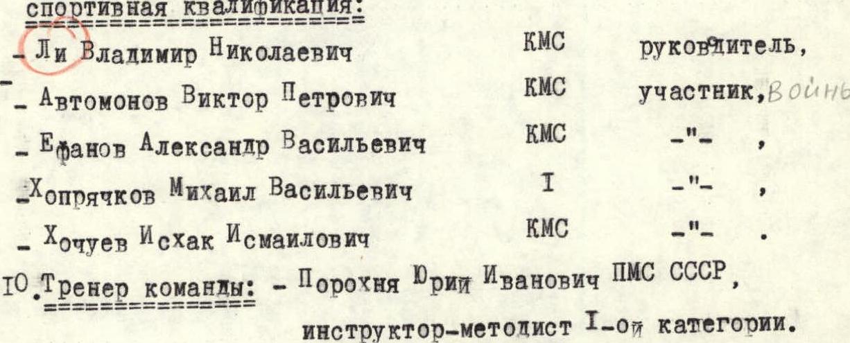
- Li Vladimir Nikolaevich — CMS, team leader
- Avtomonov Viktor Petrovich — CMS, participant, military
- Efanov Alexander Vasilievich — CMS
- Khopryachkov Mikhail Vasilievich — 1st sports category
- Khochuev Iskhak Ismailovich — CMS
- Team coach: Porokhnya Yuri Ivanovich — Honored Master of Sports of the USSR, 1st category instructor-methodologist.
II. Date of departure on the route: from July 14 to July 16, 1983.
List of routes on the photograph
- Djailyk via the Western ridge (V. Ruzhevsky) — 5A difficulty category.
- — « — via the 1st southern bastion of the Western ridge (M. Franzuzov) — 5B difficulty category.
- — « — via the 2nd southern bastion of the Western ridge (M. Khatskevich) — 5B difficulty category.
- — « — via the left part of the Western wall of the South ridge shoulder — first ascent route.
- — « — via the Western wall of the South ridge shoulder (D. Laskavy) — 5B difficulty category.
- — « — via the South ridge (V. Ruzhevsky) — 5A difficulty category.
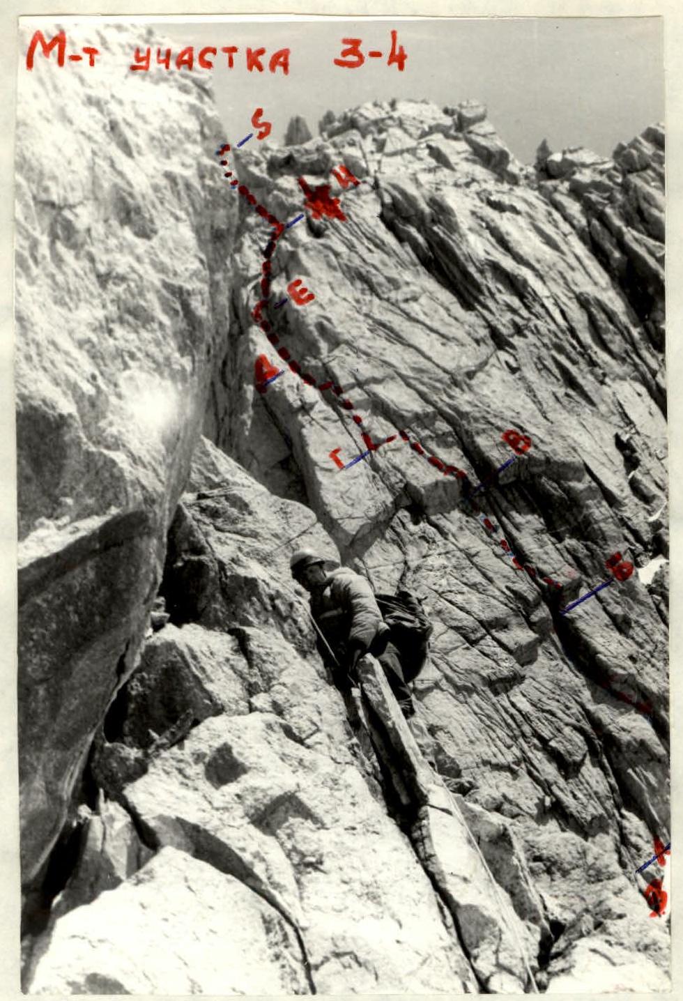

TABLE № 1 (main characteristics of the ascent route)

with an exit to the ridge and further along the несложному ridge, bypassing the summit tower on the right along the "spiral".
Route Description
From the bivouac on the platform of the rocky islet under the Northern (left) saddle of the Donkin pass, ascend left-upwards along the couloir, keeping to the right side (along the way), then into a small couloir that branches off to the right and abuts against the rocky wall (section R0–R1). Next, climb left along the wall to good ledges (section R1–R2). From the ledges, move in the direction of the snowpatch (in the form of a "star" on the photograph). From the snowpatch, go along the base of the vertical Western wall to a section with a gentler slope. Bivouac! (section R2–R3).
From this location, straight up the vertical Western wall. The wall overhangs. The wall further turns into a cleft, where the right part has a negative slope. Climb, keeping to the left side of the cleft. (Section R3a–R3b, category 6.) To the 1st cornice.
The cornice is passed with a detour to the right, after passing it 3–4 m — cross a large crevice to the left and further along the cleft, which runs parallel to the large cleft. Control point! Belay — through the cornice, sitting in a harness. To the left of the cornice, a rocky chip is visible. (Section R3b–R3c, category 6.)
The cornice passes straight up and further along two parallel clefts vertically upwards. (Section R3c–R3d, category 6.)
From here, left, pendulum-style, to a ledge for two. Further straight up along the crack, running parallel to the chimney, using artificial footholds, to a bolt piton, where a small traverse to the left to the chimney is then made, separating the chip from the base of the wall.
Up the chimney for 25 m of complex climbing, where to the left, in the middle of this chimney, there is a ledge for two. (Section R3d–R3e, category 3B.)
From the ledge up the chimney, initially crossing it to the right onto the main wall, to the middle of the chimney from the previous ledge, and then climb the chimney itself to the upper part of the chip. (Section R3e–R3f, category 5.)
From the chip straight up 3–4 m to a bolt piton, and further pendulum-style to the right to a wet crack and along it to a wide ledge. From here, the ridge of the Western wall is visible.
Further:
- to the right upwards 20 m of несложного climbing to a wide ledge (section R3e–R4, category 5).
- from the ledge to the left upwards to the ridge, несложное climbing of medium difficulty (section R4–R5, category 3–4).
Further along the snow-covered 120-meter South ridge, approach the "Claw" gendarme, which is bypassed on the left by a traverse along a 40-meter ledge, and up a steep ice-and-snow 40-meter couloir, rise behind it to a platform on the saddle of the South ridge under the summit ascent.
From the saddle:
- traverse 160–180 m along the ledges on the right side of the summit ridge.
- then ascend 60 m to the right onto the East ridge.
From this location, turn left. Further ascend 30 m along the East ridge to the summit of DJAILYK.